Drone Mapping for Urban Planning: A Professional Guide to City Development in 2026

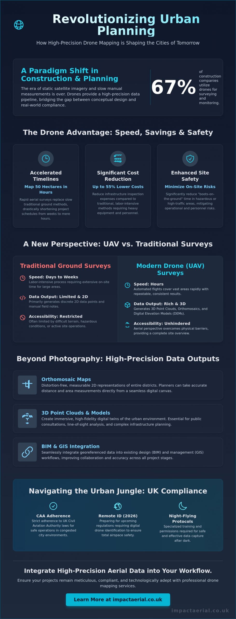
With 67% of construction companies now utilizing drones for site surveying and progress monitoring, the era of relying on static satellite imagery or slow manual measurements has officially ended. You likely feel the pressure of rapid urbanization and the need for faster project approvals while staying strictly compliant with the latest CAA regulations. Utilizing drone mapping for urban planning is no longer just about capturing aerial views; it’s a high-precision data pipeline that bridges the gap between conceptual design and real-world compliance.

Discover how high-precision aerial data accelerates urban development, ensures regulatory adherence, and provides the actionable insights needed for smarter city planning. This guide examines the technical requirements for survey-grade accuracy, including RTK and PPK capabilities, alongside the essential 2026 UK drone regulations like Remote ID and night-flying protocols. You’ll learn how to leverage highly accurate 3D models for public consultations and implement cost-effective site monitoring that can reduce infrastructure inspection expenses by up to 55%. We’ll provide the authoritative framework for integrating advanced aerial technology into your professional workflow, ensuring your projects remain meticulous, compliant, and technologically adept.

Key Takeaways

  • Accelerate project timelines by replacing traditional ground methods with rapid aerial surveys capable of mapping 50 hectares in just hours.
  • Utilize high-precision 3D point clouds and distortion-free orthomosaic maps to provide measurable data for complex urban infrastructure projects.
  • Ensure strict adherence to UK aviation law by understanding the specific certifications and safety protocols required for operations in congested city environments.
  • Improve collaboration across design teams by integrating georeferenced drone mapping for urban planning data into BIM and GIS workflows.
  • Optimize site monitoring and public consultations with actionable data that bridges the gap between conceptual design and regulatory approval.

Transforming Cityscapes: Why Drone Mapping is Essential for Modern Urban Planning

Drone mapping for urban planning is the sophisticated process of capturing georeferenced sensor data to produce high-resolution 2D and 3D outputs. Unlike traditional aerial survey methods, modern UAV technology provides a granular level of detail that satellite imagery simply cannot match. This shift is fundamental as cities move from reactive management to proactive, data-driven planning. By utilizing real-time data, developers and local authorities can make informed decisions based on current site conditions rather than outdated records.

To better understand how this technology integrates into the construction and planning phase, watch this helpful video:

In 2026, the pressures of rapid urbanization and stringent sustainability targets have made precision essential. Infrastructure is under constant strain. High-density city projects require a level of accuracy that ground-based teams struggle to provide within tight deadlines. While satellite imagery serves broad purposes, its resolution is often insufficient for the meticulous demands of modern city development. Drones bypass these limitations. They offer a reliable and cost-effective alternative for capturing site-specific information without the delays associated with orbital passes or cloud cover.

The Evolution of Urban Data Collection

The industry has transitioned from labor-intensive manual land surveys to automated UAV flight paths. These pre-programmed routes ensure consistent data coverage and repeatable results, which are vital for long-term monitoring. Modern hardware captures high-resolution 4K HDR imagery, revealing structural details and environmental factors that were previously invisible. This unique perspective provides a comprehensive overview of a site’s topography and existing assets. It allows ground teams to focus on specialized tasks rather than routine measurements.

Key Benefits for Stakeholders and Developers

One of the primary advantages of drone mapping for urban planning is the acceleration of the planning permission process. Providing local authorities with accurate, up-to-date site visualizations reduces ambiguity and speeds up approval cycles. Safety remains a paramount concern in any urban environment. By utilizing drones, developers can significantly reduce “boots-on-the-ground” time in hazardous or high-traffic areas, mitigating operational risks. Research indicates that using drones for infrastructure inspections can lead to a 55% cost reduction compared to traditional methods.

Public engagement has also seen a significant transformation. Stakeholders can now interact with immersive 3D city models that clearly illustrate the impact of proposed developments. These models provide a transparent and accessible way for the public to understand changes to their environment. This fosters trust and leads to smoother consultation phases. Through meticulous data processing, these surveys become a cornerstone of successful city development projects.

Beyond Photography: High-Precision Outputs for Urban Infrastructure

While high-resolution imagery is a staple of modern city development, the true value of drone mapping for urban planning lies in the technical datasets generated during the post-production phase. Professional UAV operations produce orthomosaic maps, which are distortion-free, measurable 2D representations of entire districts. These maps allow planners to take accurate distance and area measurements directly from their screens. By stitching together thousands of georeferenced images, we create a seamless digital canvas that serves as a reliable foundation for site analysis.

Precision goes deeper than 2D imagery. 3D point clouds generate millions of individual data points, creating a high-density digital replica of urban structures. These models allow for precise volumetric analysis and the creation of digital twins. A digital twin acts as a virtual testing ground where planners can stress-test designs against environmental factors before any ground is broken. This level of drone data for urban planning ensures that every decision is backed by empirical evidence rather than estimates.

Topographical and Volumetric Analysis

Accurate elevation data is critical for assessing drainage and flood risks in built-up areas. Using advanced drone survey techniques, teams can calculate earthworks and stockpiles with high precision. The Ground Sample Distance (GSD) determines the level of detail; a lower GSD means higher resolution and better accuracy for urban mapping. Even underground utility corridors can be identified through surface-level indicators captured in high-definition, providing a clearer picture of existing site constraints.

3D Visualisation and Public Consultation

Raw data becomes a powerful communication tool when transformed into interactive models. During community planning meetings, these 3D visualisations help stakeholders grasp the scale and impact of a project. Planners can simulate “rights to light” scenarios and identify potential view-path obstructions with surgical accuracy. For a more immersive approach, developers often use virtual tour experiences to showcase proposed developments to investors and the public. If you need to document every stage of your project’s lifecycle, our commercial drone services provide the ongoing data required for meticulous oversight.

Drone Mapping for Urban Planning: A Professional Guide to City Development in 2026

Data Accuracy and Efficiency: Comparing UAV Surveys to Traditional Methods

Traditional land surveying has long been the standard for city development, yet it often struggles to keep pace with the rapid requirements of 2026. Implementing drone mapping for urban planning allows for rapid data acquisition without the logistical bottlenecks of traditional ground-based surveying. While a manual ground crew might spend weeks traversing a complex site, a professional UAV can map 50 hectares in just a few hours. This speed doesn’t sacrifice quality; it provides a comprehensive dataset that is immediately ready for analysis.

Operational costs are significantly reduced by removing the need for heavy equipment. Traditional methods often require extensive scaffolding or disruptive road closures to gain necessary vantage points in high-density areas. Drones eliminate these overheads by operating from the air, maintaining safety while keeping surveyors out of active construction zones or high-traffic corridors. This approach ensures that your project remains on schedule without compromising the safety of your personnel or the public.

A deeper understanding of the reveals how these digital outputs integrate seamlessly into modern project management. By achieving centimetre-level precision through Real-Time Kinematic (RTK) technology, planners can trust that their digital models reflect the absolute reality of the site. This meticulous level of detail is vital for ensuring that new infrastructure aligns perfectly with existing urban assets.

The ROI of Drone Integration

The financial benefits of drone data extend far beyond the initial survey. Identifying site discrepancies early in the design phase prevents costly “re-work” during the construction stage. Drones provide a more economical solution for urban mapping than manned aircraft because they eliminate high fuel costs and complex flight logistics for localized projects. Furthermore, digital data archival creates a historical record of the site, which assists in long-term asset management and future maintenance planning.

Technical Precision: RTK vs. PPK

Achieving survey-grade accuracy requires a choice between two primary satellite positioning methods. Real-Time Kinematic (RTK) provides instant geospatial accuracy by connecting to a base station or network during flight. In “urban canyons” where satellite signals may be obstructed by tall buildings, Post-Processed Kinematic (PPK) is often the preferred choice. PPK allows for the correction of positioning data after the flight is completed, ensuring high-tier quality even in challenging environments. Professional operators often use Ground Control Points (GCPs) as an additional layer of verification, reinforcing the reliability of the final survey data.

Operating drone mapping for urban planning within a city environment requires a level of oversight far beyond standard aerial photography. The Civil Aviation Authority (CAA) maintains strict frameworks for flights in “Congested Areas,” which are defined as any area used substantially for residential, commercial, industrial, or recreational purposes. For a project to be legal and safe, pilots must possess the correct certifications to operate in proximity to buildings and people. This regulatory landscape ensures that the high-precision data collection required for city development is conducted without compromising public safety.

Risk mitigation is a cornerstone of professional urban operations. While basic insurance might suffice for open fields, the industry standard for commercial city development projects is £5 million in public liability insurance. This provides the necessary reassurance for stakeholders, developers, and local authorities. Additionally, data protection is paramount. Adhering to GDPR when mapping residential areas involves meticulous planning to ensure that identifiable personal data, such as faces or vehicle registrations, is managed or redacted during the post-production phase.

The Importance of a UK Drone License

There’s a critical distinction between a basic Flyer ID and a professional qualification like the General Visual Line of Sight Certificate (GVC). Commercial urban operations often necessitate a GVC-certified pilot to handle complex airspace requirements. These professionals are trained to manage transitions in industry standards, such as the 2026 requirements for Remote ID broadcasting and UK class markings. In high-risk environments, we often secure specific “Operating Authorisations” from the CAA, allowing for flights that fall outside standard category limits. This expertise is vital when working near restricted zones like hospitals, helipads, or major transport hubs.

Safety Protocols in Densely Populated Areas

Safety is never an afterthought; it’s the foundation of every mission. Every deployment begins with a meticulous pre-flight site assessment to identify hazards and establish emergency landing zones. We utilize DJI Enterprise hardware equipped with redundant systems, such as dual batteries and obstacle avoidance sensors, to ensure fail-safe operations even in signal-heavy urban canyons. Effective communication is also essential. We coordinate with local authorities and the police before every mission to ensure transparency and compliance. If you require a partner who prioritizes regulatory compliance and technical precision, explore our commercial property survey services to see how we manage complex urban sites.

Implementing Drone Data: From Aerial Surveys to BIM Integration

The final stage of drone mapping for urban planning involves converting raw sensor data into actionable assets for design and architecture teams. This process is often referred to as the “Scan-to-BIM” workflow. It bridges the gap between the physical site and the digital building information model. By capturing the existing environment with survey-grade accuracy, planners can populate Revit or AutoCAD with precise site conditions. This eliminates the guesswork often associated with traditional site drawings and ensures that the conceptual design is grounded in reality.

Aerial data is exported in various industry-standard formats to ensure compatibility across different software ecosystems. High-density point clouds are typically delivered as .las or .laz files, while orthomosaic maps are provided as georeferenced .tiff files compatible with ArcGIS and other GIS platforms. These datasets allow global teams to collaborate via cloud-based platforms, ensuring every stakeholder has access to the same high-resolution site replica. This centralized data approach reduces communication errors and streamlines the entire development lifecycle from the initial survey to final construction.

Seamless Workflow Integration

Converting 3D point clouds into workable CAD architectural drawings is a meticulous process. It involves extracting geometric data from millions of points to create clean, structured vectors that designers can manipulate. Orthomosaics serve as highly accurate basemaps for new urban zoning projects, providing a visual context that standard maps lack. We also utilize advanced processing techniques where AI classifies land use and vegetation from drone datasets. This automation allows for faster environmental impact assessments and more efficient site categorization, which is vital for meeting modern sustainability targets.

Choosing a Professional Drone Service

The quality of your urban data depends heavily on the hardware and expertise of the operator. Professional equipment like the DJI Mavic 3 Enterprise is essential for capturing the fine urban detail required for architectural planning. It’s not just about the flight; the value of post-production editing cannot be overstated. Clear, professional planning presentations require data that has been cleaned of noise and correctly georeferenced to national grid standards. This level of precision provides the psychological comfort and tangible benefits that professional stakeholders demand.

Impact Aerial is the partner of choice for UK-wide urban data collection. We combine technical expertise with a strict adherence to CAA safety protocols, providing the reassurance that your project is in expert hands. Our specialized services, including construction site monitoring and commercial property surveys, ensure your data is both accurate and compliant. Contact Impact Aerial for a consultation on your urban mapping project to discover how our high-end outputs can accelerate your development cycle.

Future-Proofing City Development with Precision Data

Adopting drone mapping for urban planning is no longer a luxury; it’s a technical necessity for developers who require survey-grade accuracy and seamless BIM integration. We’ve explored how high-resolution orthomosaics and 3D point clouds provide the foundational data needed for modern infrastructure, all while significantly reducing the logistical risks associated with traditional ground surveys. By moving towards automated, data-centric processes, your planning department can ensure faster approval cycles and more transparent public consultations.

Success in the urban landscape requires more than just high-end hardware. It demands a meticulous approach to regulation and safety. Our team utilizes a commercial-grade DJI Enterprise Fleet and operates under the expertise of CAA GVC Certified Pilots. We provide the psychological comfort of £5m Commercial Liability Insurance, ensuring your project remains compliant with the most stringent UK aviation standards. Transitioning your workflow to include professional aerial data will position your projects at the forefront of 2026 city development standards.

Request a Professional Urban Mapping Quote to secure the high-tier quality and authoritative data your next project deserves. We look forward to helping you build the cities of the future with precision and reliability.

Frequently Asked Questions

Is drone mapping legal in busy city centres like London or Birmingham?

Yes, drone mapping is legal in busy city centres when conducted by a CAA-certified operator holding the correct qualifications. Professional pilots must hold a General Visual Line of Sight Certificate (GVC) and often require specific Operating Authorisations for congested areas. We ensure all flights comply with current 2026 regulations, including Remote ID broadcasting and night-flying light requirements, to maintain the highest safety standards.

How accurate is drone mapping compared to traditional land surveying?

Drone mapping is highly accurate, providing centimetre-level precision that is comparable to traditional land surveying for most urban applications. By using RTK-enabled hardware and established Ground Control Points (GCPs), we verify the geospatial integrity of every pixel. This meticulous approach ensures that the digital outputs are reliable for architectural design and infrastructure engineering.

What kind of data files will I receive from an urban drone survey?

You’ll receive a variety of industry-standard files tailored to your specific software requirements. Typical outputs include georeferenced orthomosaic maps in .tiff format, 3D point clouds as .las or .laz files, and textured 3D meshes in .obj or .fbx formats. These files are ready for immediate import into GIS or CAD platforms, providing a seamless transition from the aerial survey to your internal planning workflow.

Can drones map areas with high-rise buildings and “urban canyons”?

Mapping high-rise environments and urban canyons is achievable through advanced positioning techniques. We utilize Post-Processed Kinematic (PPK) workflows to overcome the signal multipath issues common in densely built areas where tall structures might block satellite signals. This ensures that the final 3D model maintains the high-tier quality and geospatial accuracy required for professional planning applications.

How long does it take to process drone data into a 3D model?

Data processing for drone mapping for urban planning has advanced significantly, with standard projects typically completed within 24 to 48 hours. While simple maps are ready in hours, complex 3D models involving 10,000 to 20,000 images are now processed overnight. This rapid turnaround allows developers to move from site survey to design review in a fraction of the time required by traditional methods.

Do I need to notify the police or local council before a drone mapping flight?

Formal notification is not always a legal requirement under CAA rules, but we coordinate with local authorities as part of our standard safety protocol. This proactive communication helps manage public awareness and ensures that local emergency services are informed of our flight window. Our meticulous pre-flight planning includes identifying all relevant stakeholders to ensure a smooth, compliant operation.

What happens if the weather is poor on the day of the mapping flight?

Operations are rescheduled if weather conditions, such as high winds or heavy rain, compromise the safety of the flight or the quality of the data. We use professional meteorological tools to monitor local forecasts and provide regular updates to our clients. A safety-first approach ensures that we only fly when we can guarantee the high-tier precision and reliability our clients expect.

How does drone mapping help with environmental impact assessments (EIA)?

Drone mapping for urban planning assists with EIAs by providing precise elevation models for flood risk analysis and high-resolution imagery for habitat mapping. These digital datasets allow planners to visualize the environmental impact of proposed structures with surgical precision. This data-centric approach ensures that sustainability targets are met while identifying potential ecological constraints early in the development lifecycle.

Drone Survey Deliverables Explained: A Complete Guide for UK Professionals (2026)

A high-resolution aerial photograph is not a survey; it is a liability if it lacks the georeferenced precision required for engineering-grade decisions. You likely agree that while drones capture stunning visuals, the real value lies in the technical data behind the pixels. Many UK project managers still face the frustration of receiving imagery that looks impressive but won’t align with their existing AutoCAD or BIM workflows. This gap between expectation and reality usually comes from a lack of clarity regarding the specific outputs a professional operator must provide.

In this guide, we provide drone survey deliverables explained to bridge the gap between raw aerial data and actionable project success. You’ll learn how to distinguish between orthomosaics, point clouds, and digital terrain models, ensuring your next hire delivers files compatible with Revit or Civil 3D. We also outline the essential CAA GVC certifications and commercial insurance requirements that provide peace of mind for site safety. This article offers a clear roadmap for integrating precise 2D and 3D data into your 2026 project planning with absolute confidence.

Key Takeaways

  • Distinguish between qualitative visual inspections and quantitative metric surveys to ensure you are commissioning the correct data set for your specific project needs.
  • Gain full technical clarity with our guide to drone survey deliverables explained, covering everything from 2D orthomosaics to high-density 3D point clouds and digital twins.
  • Unlock actionable business intelligence by learning how to calculate precise earthwork volumes and identify critical infrastructure faults through professional thermal reports.
  • Enhance stakeholder engagement and project planning by utilizing realistic 3D textured models for immersive virtual walkthroughs and site presentations.
  • Ensure operational compliance by understanding why CAA GVC certification and £5m commercial liability insurance are non-negotiable for professional drone surveys in the UK.

Understanding Drone Survey Deliverables: Data vs. Imagery

For UK construction and engineering professionals, drone survey deliverables explained effectively must start with a shift in perspective. You aren’t just paying for aerial photography. While a standard visual inspection is qualitative, providing a visual record of an asset’s condition, a professional drone survey is quantitative. It produces measurable, geo-spatial data sets that function as a digital twin of your site. In 2026, the distinction is clear: imagery is for looking, but data is for measuring.

The most critical factor in any deliverable is accuracy, defined by the Ground Sample Distance (GSD). GSD represents the distance between the centres of two consecutive pixels measured on the ground. A GSD of 1cm means one pixel in your image represents 1cm squared in reality. Impact Aerial prioritises this precision by using CAA GVC certified pilots who understand the technical requirements of data integrity. This certification ensures that every flight adheres to UK safety regulations while maintaining the rigorous standards required for survey-grade results.

To better understand this concept, watch this helpful video:

The Anatomy of a Professional Drone Survey

Professional data capture relies on two primary methods: Photogrammetry and LiDAR. Photogrammetry uses high-resolution overlapping images to triangulate points in space, while LiDAR uses laser pulses to measure distances directly. To achieve sub-centimetre accuracy, we use Ground Control Points (GCPs). These are physical markers on the ground with known coordinates that “pin” the digital map to the real world. A drone survey deliverable is a digital representation of physical assets with survey-grade coordinates.

Software Compatibility and File Formats

Data is only useful if your team can use it. We provide deliverables in industry-standard formats to ensure they work with your existing workflows. Common formats include .TIFF for orthomosaics, .LAS or .LAZ for point clouds, and .OBJ or .DXF for 3D meshes and CAD drawings. These files integrate seamlessly with AutoCAD, Revit, and BIM software. Impact Aerial manages the entire data pipeline to provide clients with added peace of mind, ensuring that the “drone survey deliverables explained” in your project brief are the exact files your surveyors need for immediate analysis.

Essential 2D Deliverables: Orthomosaics and Topographic Maps

Traditional satellite imagery often lacks the granular detail required for modern UK construction and engineering standards. When drone survey deliverables explained are discussed, 2D outputs remain the foundational requirement for most site managers. These deliverables provide a high-resolution, measurable base layer that informs everything from initial planning to final handovers.

Orthomosaic Maps: The New Site Standard

An orthomosaic is a geometrically corrected aerial map. It’s created by stitching together thousands of individual high-resolution images using photogrammetry. Unlike a standard aerial photograph, an orthomosaic is distortion-free. This means you can measure distances, areas, and volumes directly on the map with sub-5cm accuracy. It’s a “true” map that reflects the site’s exact state at a specific moment in time.

UK developers now use these maps to replace outdated satellite views for active site monitoring. They’re indispensable for planning applications and resolving boundary disputes where precision is mandatory. For deeper technical context on how we capture this imagery, see our guide to drone surveys. These maps provide a clear, indisputable record of progress that stakeholders can access remotely.

Topographic Data and Contour Mapping

Topographic surveys translate complex elevation data into readable 2D formats. By using contour lines, we help project managers visualise terrain slope and height variations across the entire site. This data is vital for identifying drainage issues and flood risks early in the project lifecycle. It’s much cheaper to adjust a design in the digital phase than to fix a flooding issue after the concrete is poured.

The efficiency of UAV land surveying is significant. Traditional methods using total stations or GPS rovers often take days to cover a 10-hectare site. A drone can capture the same area in under 30 minutes. The resulting data includes millions of elevation points, providing a far more detailed picture of the terrain than traditional spot levels. These outputs integrate directly into CAD software, allowing engineers to produce site plans in .dwg or .dxf formats with ease.

DSM vs. DTM: Knowing the Difference

Precision in drone survey deliverables explained requires an understanding of two distinct elevation models:

  • Digital Surface Model (DSM): This captures the earth’s surface plus all objects on it. It includes buildings, stockpiles, and vegetation. It’s the standard choice for calculating the volume of a gravel mound or checking for crane clearance.
  • Digital Terrain Model (DTM): This filters out man-made and natural objects to show only the “bare earth” ground surface. Engineers use DTMs for hydrological modelling and earthworks planning because they show the true shape of the land.

If you’re unsure which 2D deliverable fits your specific project requirements, contact our technical team to discuss your site’s objectives.

High-Density 3D Data: Point Clouds and Digital Twins

Drone technology in 2026 has transformed how site data is captured and utilised across the UK construction and engineering sectors. High-density 3D data provides a spatial context that traditional 2D orthomosaics simply cannot match. When professionals look for drone survey deliverables explained, they’re often seeking the ability to interact with a site virtually to perform volumetric calculations or structural analysis. This level of detail allows for a comprehensive understanding of a project’s physical state without the high costs of traditional ground-based surveying methods.

Point Clouds: The Foundation of 3D Modelling

Point clouds are the primary output of professional photogrammetry or LiDAR sensors. They consist of millions of individual data points, each assigned a specific X, Y, and Z coordinate to form a precise 3D coordinate system. A point cloud is the digital skeleton of a physical structure, accurate to within millimetres. This precision is vital for structural health monitoring, as high point density allows engineers to detect minute shifts or surface deformations that might be missed during a manual inspection.

In a virtual environment, these points enable precise distance, area, and height measurements. For a typical UK construction project, having this data on hand reduces the reliance on expensive scaffolding or high-access equipment for initial assessments. It provides a reliable baseline for “as-built” surveys, ensuring that the physical construction aligns perfectly with the original architectural intent.

  • Data Density: Capturing thousands of points per square metre for granular detail.
  • Measurement Accuracy: Extracting vertical and horizontal dimensions with survey-grade precision.
  • Interoperability: Exporting data in .LAS or .E57 formats for use in CAD software.

Digital Twins and Virtual Tours

A digital twin is a 3D textured model that serves as a realistic, high-resolution replica of a physical asset. We create these by “wrapping” high-quality aerial imagery over the point cloud skeleton. These models are essential for stakeholder presentations and commercial property marketing, providing an immersive experience that static photos cannot replicate. For visual-first 3D applications, you can refer to our drone photography guide to see how professional imagery enhances these models.

Integrating these models into Building Information Modelling (BIM) software streamlines the project lifecycle. It allows for seamless data-gathering that informs every stage from design to demolition. Virtual tours also improve site safety by reducing the frequency of site visits, keeping personnel out of hazardous areas while still providing full visibility of the worksite. Using these drone survey deliverables explained here gives project managers peace of mind, knowing they’re working with objective, repeatable, and highly detailed data sets.

Actionable Insights: Volumetrics and Thermal Reports

The true value of drone survey deliverables explained lies in their ability to transform raw pixels into precise, actionable business intelligence. While visual maps provide context, technical reports provide the data required for financial forecasting and risk management. In the UK construction and energy sectors, these deliverables have become the standard for maintaining tight project timelines and ensuring safety compliance.

Volumetric Analysis for Construction and Mining

Drones calculate cut-and-fill volumes with up to 99% accuracy, a figure supported by 2024 industry benchmarks comparing photogrammetry to traditional ground based surveys. Instead of sending a surveyor to climb over unstable stockpiles with a GPS rover, a drone captures thousands of data points in a single flight. This significantly reduces the physical risk to personnel while providing a comprehensive digital surface model (DSM).

  • Monthly Commercial Valuations: Quantity surveyors use volumetric data to verify subcontractor claims and manage budgets with precision.
  • Logistics Planning: Accurate excavation data allows site managers to coordinate the exact number of haulage vehicles needed, reducing fuel costs and carbon emissions.
  • Safety Compliance: Removing the need for manual measurements on active sites minimizes the risk of accidents involving heavy machinery or falls from height.

Specialist Thermal and Solar Surveys

For the UK’s renewable energy sector, thermal deliverables are essential for maintaining ROI on large scale PV solar farms. High quality thermal data requires professional grade equipment. Our team utilizes DJI Enterprise drones equipped with radiometric sensors to identify thermal anomalies that are invisible to the naked eye. These reports typically include a thermal orthomosaic and a detailed list of defects, such as “string” failures or individual failing cells.

The precision of these reports allows asset managers to target maintenance exactly where it is needed. Identifying a single faulty inverter or a bypass diode failure can prevent a significant drop in energy yield. In many cases, early detection through drone thermography can improve farm output by 15% compared to sites using manual spot-checking methods. Beyond solar, these thermal deliverables are used for building heat loss surveys, helping property developers meet strict UK energy efficiency standards.

High resolution imagery and annotated defect maps also redefine roof inspections. Rather than spending thousands of pounds on scaffolding or cherry pickers for a preliminary look, a drone provides a 4K view of every tile, gutter, and flashing. For land management, we provide NDVI (Normalized Difference Vegetation Index) data. This allows estate managers to monitor plant health and soil moisture levels across hundreds of acres in a single afternoon.

Secure the data you need for your next project. Contact Impact Aerial for professional drone survey services today.

Choosing a Professional Partner for Drone Data Collection

Selecting a competent provider is the final, most critical step in the process. Having drone survey deliverables explained is useful, but the quality of those outputs depends entirely on the operator’s technical proficiency and legal compliance. In the United Kingdom, the Civil Aviation Authority (CAA) General Visual Line of Sight Certificate (GVC) is a non-negotiable requirement for commercial drone surveys. This certification ensures the pilot has undergone rigorous training in airspace law and flight safety. Choosing an uncertified operator doesn’t just risk poor data quality; it can lead to heavy fines and the invalidation of your project’s insurance policies.

For added peace of mind, Impact Aerial maintains £5m in commercial liability insurance. This high level of indemnity is often a mandatory entry requirement for Tier 1 construction sites, infrastructure projects, and high-value commercial assets. It demonstrates a level of professional maturity that smaller, hobbyist-led operations cannot match. Beyond insurance, you should evaluate a partner based on their post-production capabilities. Capturing raw data is only half the job. A professional partner must have the computing power and software expertise to process thousands of 4K images into accurate 3D models or centimetre-perfect orthomosaics.

Our approach to safety planning is meticulous. We produce site-specific Risk Assessments and Method Statements (RAMS) for every deployment. This technical rigour ensures that data collection occurs without compromising the safety of your personnel or the public. We handle the complexities of UK airspace notifications and local authority permissions, allowing your team to focus on the project at hand.

The Impact Aerial Quality Standard

We use the latest DJI Enterprise commercial drones to ensure your data is captured with 4K High Dynamic Range (HDR) precision. This technology allows us to maintain high contrast and detail even in the flat lighting conditions common across the UK. Being Birmingham-based gives us a strategic advantage for rapid deployment to projects across the West Midlands and the rest of the country. Our commitment to transparency is absolute. You can read our UK drone license guide to see exactly how we maintain compliance with 2026 CAA regulations.

Next Steps: From Consultation to Deliverables

Our workflow is structured to provide clarity from day one. We start with a consultation to define your specific requirements, followed by comprehensive site RAMS. Once the data capture is complete, we process the files for secure, cloud-based delivery. This ensures your team can access high-resolution assets from any location. If you’re ready to integrate professional aerial data into your workflow, contact Impact Aerial for a professional drone survey quote today. We provide the technical expertise and regulatory assurance needed to turn aerial perspectives into valuable business intelligence.

Maximise Project Accuracy with High-Resolution Aerial Insights

Success in the 2026 UK construction and surveying landscape depends on moving beyond simple imagery. Having drone survey deliverables explained allows your team to leverage high-density 3D point clouds and orthomosaics for precise site planning. These tools provide the actionable data needed for complex volumetric reports and topographic analysis. It’s about turning raw aerial footage into a reliable digital twin that supports every stage of your project’s lifecycle.

Impact Aerial provides the technical expertise required to capture this high-grade data. We utilise DJI Enterprise 4K HDR equipment to ensure every pixel carries value. Our team consists of CAA GVC Certified pilots, and we maintain £5m commercial liability insurance to ensure your site stays protected. We don’t just fly drones; we provide the professional data-gathering services that modern UK industries demand.

Take the next step in digitising your workflow today. Book your professional UK drone survey with Impact Aerial and secure the precision your business needs to lead the market.

Frequently Asked Questions

What file formats are typically provided in a drone survey?

Drone survey deliverables are typically provided in industry-standard formats such as GeoTIFF for orthomosaics and .LAS or .LAZ for 3D point clouds. For CAD integration, you’ll receive .DXF or .DWG files, while 3D meshes are often delivered as .OBJ or .FBX files. These formats ensure seamless integration into existing BIM and GIS workflows used by 95% of UK architectural and engineering firms.

How accurate are drone survey deliverables compared to traditional methods?

When reviewing drone survey deliverables explained for precision, these outputs often achieve 1cm to 3cm relative accuracy when using Ground Control Points (GCPs) or RTK-enabled aircraft. This matches or exceeds traditional total station results for large-scale topographic mapping. While traditional methods remain superior for single-point precision, drones capture millions of data points, providing a 400% increase in data density compared to manual surveying.

Do I need special software to view drone survey data?

You don’t always need expensive software to view your data because we provide web-based viewers for many projects. For detailed analysis, professionals use platforms like AutoCAD, Revit, or ArcGIS. If you’re a first-time user, we offer lightweight PDF reports and browser-based 3D models that require zero installation, making the data accessible to all project stakeholders immediately.

What is the difference between an orthomosaic and a standard aerial photo?

An orthomosaic is a geometrically corrected map composed of hundreds of individual photos, whereas a standard aerial photo is just a single perspective shot. Because the orthomosaic is orthorectified, it has a uniform scale across the entire image. This allows you to measure distances and areas with 99.8% precision, something that’s impossible with a standard, distorted aerial photograph.

How long does it take to receive the deliverables after the drone flight?

Most clients receive their processed data within 48 to 72 hours after the flight is completed. Large-scale projects involving complex 3D rendering or BIM integration can take up to 5 business days. This represents a 70% reduction in lead time compared to traditional land surveys, which often take weeks to process and draft manually.

Can drone survey data be used for legal boundary disputes in the UK?

Drone data serves as powerful evidence in UK boundary disputes, but it must be captured by a CAA GVC certified pilot to ensure legal weight. While the imagery provides clear visual proof, the Land Registry typically requires a RICS-qualified surveyor to sign off on any formal boundary amendments. Since 2021, high-resolution drone maps have been increasingly accepted in UK courts to resolve land use disagreements.

Are drone surveys compliant with UK health and safety regulations?

Every operation we conduct is fully compliant with UK health and safety regulations and CAA GVC standards. We provide a comprehensive Risk Assessment and Method Statement (RAMS) for every site before take-off. Using drones reduces at-height risks by 100% during roof and chimney inspections, directly supporting your legal obligations under the Work at Height Regulations 2005.

What is a point cloud and why do I need one?

A point cloud is a collection of millions of individual data points, each with its own X, Y, and Z coordinates. You need this deliverable to create highly accurate 3D models and digital twins of buildings or terrain. It’s the foundational data used in BIM (Building Information Modelling) to detect structural issues or calculate accurate volume measurements for stockpiles with 99% accuracy.

Avoiding Common Drone Survey Mistakes: A Guide to Professional Data Collection

A Tier 1 contractor in Birmingham recently discovered that a single missed setting in their photogrammetry software rendered a £4,500 site survey completely unusable for planning. It’s a frustrating reality for many firms. While drones are transformative tools, the technical precision required means that even small oversights lead to significant project delays. You likely understand that accuracy is non-negotiable for site planning, yet the complexities of avoiding common drone survey mistakes can feel like a moving target.

This guide ensures your next flight delivers the professional results your clients expect by providing a roadmap to precision data collection. You’ll learn how to navigate UK Civil Aviation Authority (CAA) regulations and account for unpredictable British weather patterns that cause roughly 22% of all mission cancellations. We’ll break down the essential steps for capturing high-resolution, georeferenced data that keeps your projects on schedule and within budget.

Key Takeaways

  • Understand the critical importance of CAA regulations and commercial liability insurance to protect your business from the significant risks of non-compliant flight operations.
  • Master the technical distinction between relative and absolute accuracy, ensuring your data aligns perfectly through the strategic use of Ground Control Points (GCPs).
  • Learn how to mitigate the impact of unpredictable British weather and suboptimal lighting, a vital step in avoiding common drone survey mistakes that degrade sensor performance.
  • Adopt professional post-processing standards and rigorous data organisation techniques to prevent the “garbage in, garbage out” cycle that often stalls complex survey projects.
  • Evaluate the hidden financial risks of DIY drone operations and why partnering with a professional service provides the technical expertise required for high-quality, actionable data.

Regulatory and Planning Mistakes: More Than Just Flying

Successful data collection begins long before the drone leaves the ground. Many project managers assume that a pilot’s ability to manoeuvre a drone is the only metric that matters, but this oversight is a primary cause of project failure. Avoiding common drone survey mistakes requires a deep understanding of the Civil Aviation Authority (CAA) framework. Since the major regulatory overhaul in December 2020, the legal requirements for operating in UK airspace have become more stringent. Treating a survey as “just a quick flight” ignores the massive legal liability that follows a non-compliant operation.

To better understand how simple planning errors can derail a professional project, watch this helpful video:

Professional operators don’t just turn up and fly. They produce site-specific Risk Assessments and Method Statements (RAMS) that account for local hazards, nearby structures, and public safety. Without these documents, your site insurance is likely void. A meticulous pilot will also ensure their flight plan respects the principles of photogrammetry, as even slight deviations in altitude or overlap can render the entire dataset useless. Precision starts with planning, not just piloting.

The CAA GVC vs PfCO Confusion

The UK drone industry is currently transitioning from the old PfCO (Permission for Commercial Operation) to the GVC (General Visual Line of Sight Certificate). Many businesses mistakenly hire pilots with expired or irrelevant qualifications. You should always verify a pilot’s credentials by requesting their CAA Operator ID and flyer ID before they arrive on-site. Hiring an uncertified pilot isn’t just a safety risk; it’s a breach of health and safety protocols that can lead to five-figure fines for the hiring company.

Insurance Gaps and Liability

Standard public liability insurance rarely covers commercial drone operations. For added peace of mind, you must ensure your contractor holds specific commercial drone insurance that complies with EC 785/2004. In the UK construction and surveying sectors, a £5m liability cover is the industry standard. If an incident occurs and the pilot is found to be non-compliant with CAA regulations, the insurer will likely refuse the claim, leaving your business to shoulder the financial and legal fallout.

  • Verify Certification: Ensure the pilot holds a valid GVC or A2 CofC.
  • Check Insurance: Confirm the policy is specifically for commercial UAV operations.
  • Review RAMS: Don’t accept generic risk assessments; they must be site-specific.

Technical Accuracy Errors: Why Your Data Doesn’t Line Up

One of the most effective ways of avoiding common drone survey mistakes is understanding that high-quality visuals don’t always equate to high-quality data. Professional surveys require a clear distinction between relative and absolute accuracy. Relative accuracy ensures that the distance between two points on your map is correct; absolute accuracy ensures those points align perfectly with their real-world coordinates on the Earth’s surface. Relying solely on a drone’s internal GPS often leads to an absolute error margin of 3 to 5 metres, which is unacceptable for construction or boundary disputes.

Neglecting Ground Control Points (GCPs) remains a frequent pitfall for inexperienced operators. Even with advanced sensors, GCPs act as physical anchors that tie your digital model to the ground. Without at least five well-distributed GCPs per flight area, photogrammetry software lacks the necessary reference to correct “bowl effects” or scaling errors. Professionals also recognise the limitations of consumer-grade hardware. While a £1,000 hobbyist drone captures decent video, its rolling shutter creates “jello” distortion during movement. Commercial-grade platforms equipped with global shutters are essential for 99% of professional survey applications to ensure every pixel is captured simultaneously.

Incorrect camera settings frequently ruin datasets before the drone even lands. A shutter speed slower than 1/800th of a second introduces motion blur that prevents software from identifying tie points. Adhering to fundamental practices for drone remote sensing ensures that ISO remains low to prevent digital noise, which otherwise obscures fine details in 3D point clouds.

The Role of RTK and PPK Technology

Real-Time Kinematic (RTK) is a satellite navigation technique used to enhance the precision of position data derived from satellite-based positioning systems, providing centimetre-level accuracy in real-time. RTK is ideal for sites with strong telemetry links, while Post-Processed Kinematic (PPK) is superior for remote UK locations where signal dropouts are common. When setting up a drone survey, the most common base station error is failing to allow the unit to “soak” for at least 20 minutes to establish a stable position, leading to a shift in the entire dataset.

Flight Path and Overlap Issues

For high-quality 3D modelling, a minimum of 75% frontal overlap and 70% side overlap is non-negotiable. Reducing these values to save battery life is a false economy that results in “holes” in the final mesh. Most flight planning software uses a “mowing the lawn” grid pattern, but failing to account for wind resistance can cause the drone to tilt, altering the camera angle and skewing the Ground Sampling Distance (GSD). If your altitude fluctuates by even 5 metres, your GSD changes, meaning your resolution is no longer consistent across the site. For added peace of mind, hiring a CAA GVC certified specialist ensures these technical variables are managed with professional precision.

Environmental and Site Factors: Fighting the Elements

Operating in the United Kingdom presents a unique set of challenges for aerial data collection. Many operators fail because they don’t account for the subtle shifts in atmospheric conditions that compromise sensor accuracy. Successfully avoiding common drone survey mistakes requires a deep understanding of how the environment interacts with high-precision hardware. Professional data gathering isn’t just about the pilot’s skill; it’s about managing the unpredictable variables of the site itself.

Wind, Rain, and Sensor Integrity

Wind is the primary enemy of image sharpness. While a commercial drone might stay airborne in 25mph winds, gusts exceeding 15mph often introduce micro-vibrations. These vibrations result in motion blur that renders photogrammetry software unable to find tie points. We’ve seen projects where 40% of the data was discarded due to “light drizzle” flights. Unless a drone carries an IP45 rating or higher, moisture ingress will eventually lead to catastrophic mid-air failure. Temperature also dictates mission success. Below 5°C, LiPo battery chemical reactions slow down, reducing a standard 30-minute flight window to just 18 or 20 minutes. For added peace of mind, our team monitors local METAR reports before any deployment in Birmingham or the wider West Midlands.

Shadows and Contrast in Photogrammetry

It’s a common misconception that bright sunshine is ideal for surveying. Shooting at high noon creates harsh, vertical shadows that hide critical details in roof valleys or structural crevices. These “black holes” in the data prevent the software from generating a continuous point cloud. Overcast conditions provide diffused, even lighting that’s often superior for 3D modelling. To maintain high standards, we follow principles found in the USGS guidelines for UAS imagery to manage radiometric consistency. This is especially vital when surveying solar farms, where glare from panels can “blind” the sensor, creating 100% white pixels that contain zero usable data.

Magnetic interference is another silent project killer. Surveying near reinforced concrete, large steel structures, or 400kV power lines can confuse the drone’s internal compass. This leads to “toilet bowling” or erratic flight patterns. A professional survey must also account for site-specific obstructions like cranes or temporary scaffolding. Before we launch, we cross-reference the latest CAA NATS maps to ensure we aren’t infringing on restricted airspace or temporary “no-fly” zones. Overlooking these factors is a major hurdle in avoiding common drone survey mistakes and can lead to legal complications or compromised data sets.

Data Integrity and Post-Processing Blunders

Capturing high-resolution imagery is only half the battle. Professional data collection relies on the “garbage in, garbage out” principle; if the initial flight parameters or sensor calibrations are off, no amount of post-processing can fix the resulting inaccuracies. A critical part of avoiding common drone survey mistakes involves meticulous data management from the moment the SD card is removed from the aircraft.

Poor file naming and chaotic folder structures often lead to significant project friction. A 2023 industry report indicated that 14% of survey rework is caused by mislabelled data or lost files during transit. You should establish a consistent naming convention that includes the date, site location, and flight number. Establishing these protocols is a vital step in avoiding common drone survey mistakes that can cost a firm upwards of £1,500 in lost billable hours. Crucially, never leave a site without a verified backup. We recommend using a ruggedised field drive to mirror your data before you pack up your kit to ensure hardware failure doesn’t ruin your day.

  • Ensure output formats match client requirements, such as .LAS for point clouds or .DXF for CAD.
  • Verify coordinate systems, specifically OSGB36 for UK projects, to prevent alignment shifts.
  • Check for image gaps in the dataset before leaving the survey area.
  • Confirm all files are correctly indexed to avoid delays during the photogrammetry phase.

3D Modelling and Point Cloud Errors

Raw point clouds often contain “noise” from moving vehicles or vegetation. Failing to clean this data results in “ghosting” effects that compromise accuracy. Large-scale orthomosaics can suffer from stitching errors where images don’t align, creating visual breaks. To ensure compatibility with BIM software like Revit, you must verify decimation levels. Too much detail can crash a client’s system; too little renders the survey useless for engineering.

The Importance of Human Verification

Automated photogrammetry software isn’t a replacement for a trained eye. Software often struggles with vertical surfaces, causing “warping” on the sides of buildings. Spotting these anomalies requires a manual review of alignment logs. Using a professional survey drone expert in the editing suite ensures every centimetre is validated against Ground Control Points. This human-led approach separates a basic photo from a survey-grade asset.

Don’t let post-processing errors devalue your project data. Contact Impact Aerial today for professional drone survey services that guarantee precision and compliance.

Professional Drone Services vs DIY: Calculating the Real Cost

Many UK construction and surveying firms initially consider purchasing a consumer drone to handle inspections in-house. While a retail drone might only cost £1,200, the true operational cost of a DIY programme often exceeds £12,000 in the first year. This figure includes CAA GVC training, specialist photogrammetry software subscriptions, and high-tier commercial insurance. When you hire experts, you aren’t just paying for a pilot; you’re investing in a managed drone services workflow that covers everything from airspace clearing to complex data processing.

The financial logic of outsourcing rests on the ROI of precision. A single data error caused by an inexperienced internal pilot can lead to site delays costing upwards of £3,000 per day. Avoiding common drone survey mistakes means ensuring the data is actionable the moment it hits your desk. Professional operators provide a level of reliability that internal teams often struggle to match without years of flight experience. For added peace of mind, Impact Aerial carries £5 million in public liability insurance, protecting your project from the financial risks associated with site accidents or regulatory breaches.

Accessing Commercial-Grade Technology

Consumer drones like the DJI Mini series are excellent for photography but lack the hardware for professional surveying. These models use electronic shutters that cause “rolling shutter” distortion, ruining map accuracy at high speeds. Impact Aerial utilises the latest 4K HDR DJI Enterprise drones equipped with mechanical shutters and RTK (Real-Time Kinematic) modules. This technology delivers 2cm horizontal accuracy, something consumer models cannot achieve. Our fleet also supports thermal and multispectral sensors, allowing us to detect structural heat loss or moisture ingress that remains invisible to the naked eye.

Conclusion: Building a Robust Survey Strategy

Successfully avoiding common drone survey mistakes requires a commitment to quality over initial cost savings. Relying on outdated hardware or uncertified pilots puts your data and your reputation at risk. A robust strategy focuses on high-resolution outputs and strict adherence to CAA regulations. Use this final checklist when selecting your drone partner:

  • Verify their CAA GVC or PfCO certification status.
  • Confirm they use Enterprise-grade hardware with RTK capabilities.
  • Request proof of specific commercial drone liability insurance.
  • Check for a portfolio of similar surveying or inspection projects.
  • Ensure they can provide data in the specific formats your CAD or BIM software requires.

Don’t leave your site data to chance. Contact Impact Aerial for a professional consultation and ensure your next survey is delivered with centimetre-level precision and full regulatory compliance.

Secure Precision and Compliance for Your Next Survey

Achieving millimetre-accurate results isn’t just about owning a drone; it’s a matter of technical rigour and strict regulatory adherence. Avoiding common drone survey mistakes requires a deep understanding of how environmental variables and complex post-processing affect your final dataset. While DIY attempts might seem cheaper, they often result in costly data misalignment or legal risks that can stall a project for weeks. Professional services eliminate these variables, ensuring every flight delivers actionable, high-quality intelligence.

Impact Aerial brings expert-level certainty to your site. Our CAA GVC Certified Pilots operate a high-spec DJI Enterprise commercial fleet, capturing 4K HDR imagery that meets the most demanding industrial standards. For added peace of mind, we back our operations with £5m commercial liability insurance, protecting your assets and your reputation. We’re ready to help you navigate the complexities of modern aerial data collection with efficiency and precision. Your project deserves the reliability that only a vetted, professional operator can provide.

Request a Quote for Your Professional Drone Survey

Frequently Asked Questions

What is the most common mistake made during a drone survey?

Inadequate pre-flight planning and insufficient image overlap are the most frequent errors encountered in the field. Professional operators must maintain a minimum of 75% frontal and 60% side overlap to ensure the photogrammetry software can accurately stitch the data. Failing to account for these technical requirements is a primary factor in avoiding common drone survey mistakes during the initial data-gathering phase.

Do I need a special license to conduct a commercial drone survey in the UK?

You require a General Visual Line of Sight Certificate (GVC) issued by the Civil Aviation Authority (CAA) to operate drones commercially within the Specific Category. Since the regulatory transition in December 2020, professional pilots must also hold valid commercial liability insurance that complies with UK Regulation (EC) No 785/2004. This typically involves a minimum cover of £5 million to provide clients with total peace of mind during complex site operations.

How much accuracy can I expect from a professional drone survey?

A professional survey typically delivers a Ground Sampling Distance (GSD) of between 1cm and 3cm per pixel depending on flight altitude. When our team utilises high-specification sensors and Ground Control Points, you can achieve absolute global accuracy of 20mm to 50mm across the entire site. These precise figures are essential for topographical mapping where 95% of data points must fall within the specified project tolerances.

Can I use a standard DJI Mavic for a land survey?

A standard DJI Mavic lacks the mechanical shutter and RTK capabilities required for professional survey-grade precision. Consumer drones use electronic rolling shutters that cause “jello” distortion at high speeds, which can introduce spatial errors of 5 metres or more in 3D models. Professional land surveys demand enterprise-grade hardware like the DJI Matrice 350 RTK to ensure sub-centimetre data reliability and repeatable results.

What happens if a drone survey is conducted in poor lighting?

Poor lighting increases ISO noise and motion blur, which prevents photogrammetry software from identifying distinct tie points between images. Surveys conducted with less than 1,000 lux of ambient light often result in “noisy” point clouds and distorted digital twin reconstructions. Professional teams monitor solar noon and cloud cover to ensure a consistent 1/500th shutter speed for crisp, usable data collection.

Why are Ground Control Points (GCPs) so important?

Ground Control Points anchor your aerial data to real-world coordinates, ensuring the survey is geographically accurate rather than just internally consistent. Without at least 5 to 8 GCPs per flight area, a survey might suffer from a “bowl effect” or be displaced by several metres from its true location. Using these physical markers is a proven method for avoiding common drone survey mistakes related to global positioning and scaling.

How does wind speed affect drone survey data?

Wind speeds exceeding 15 knots significantly degrade battery life and gimbal stability, which often leads to blurred imagery and inconsistent data. High winds cause the aircraft to tilt aggressively to maintain its position, altering the camera angle and reducing the effective overlap of the flight path. Professional operators ground flights when gusts reach 20 knots to protect both the equipment and the integrity of the data.

What is the difference between RTK and standard GPS drones?

Real-Time Kinematic (RTK) drones provide centimetre-level positioning by constantly correcting satellite signals against a fixed base station or network. Standard GPS drones have a horizontal margin of error between 1.5 and 5 metres, which is unsuitable for high-precision engineering or construction projects. RTK technology reduces the number of physical ground markers needed while maintaining a 99.9% reliability rate for spatial coordinates.

What is a Drone Surveyor? A Complete Guide to Aerial Surveying

Is drone surveying just a high-tech gimmick, or is it a genuinely transformative tool for professional projects? If you’re exploring aerial surveying, you likely have questions about data accuracy, compliance with complex UK regulations, and crucially, how to distinguish a certified expert from an enthusiastic hobbyist. These are valid concerns in a rapidly advancing industry, where the quality of your data and the legality of its acquisition are paramount.

The reality is that a professional drone surveyor offers a revolutionary approach to data gathering, delivering unparalleled accuracy, safety, and efficiency for projects in construction, land management, and infrastructure. This comprehensive guide is designed to provide clarity and peace of mind. We will demystify the role of a drone surveyor, detail the key benefits for your business, and explain technical outputs like orthomosaics and point clouds in plain English. Most importantly, we’ll equip you with the essential knowledge to choose a fully qualified, CAA-certified, and insured expert, ensuring you receive top-quality, actionable data you can rely on.

What is a Drone Surveyor and How Do They Differ from Traditional Surveyors?

A drone surveyor is a certified professional who utilises Unmanned Aerial Vehicles (UAVs) to conduct high-precision surveys and inspections. This role is a sophisticated blend of expert piloting, governed by Civil Aviation Authority (CAA) regulations, and deep expertise in geospatial data analysis. Far more than just a pilot, a professional drone surveyor is a data specialist whose primary objective is to capture vast amounts of high-resolution aerial data, which is then processed to create highly accurate 2D orthomosaic maps, 3D digital elevation models, and detailed asset reports.

To see this advanced data-gathering capability in action, the video below showcases a LiDAR drone project:

The Role of a UAV (Unmanned Aerial Vehicle) in Modern Surveying

In modern land and asset management, UAVs serve as advanced data-gathering tools, revolutionising the efficiency and scope of surveying projects. These commercial-grade drones can be equipped with a range of sophisticated sensors-from high-resolution RGB cameras for photogrammetry to thermal sensors for heat-loss analysis and LiDAR for creating precise point clouds. This technology provides a significant advantage in the field of Aerial survey by enabling safe access to difficult or hazardous areas, such as unstable terrain, active construction sites, or tall structures, without putting personnel at risk.

Traditional Surveying vs. Drone Surveying: A Comparison

While both methods aim for accuracy, the operational differences are substantial. Drone surveying offers clear, measurable advantages in key areas, providing tangible benefits for project timelines, safety protocols, and overall costs.

  • Time & Speed: A survey that might take a ground crew days or weeks with a total station can often be completed in a matter of hours by a drone, dramatically accelerating project schedules.
  • Safety: Drones eliminate the need for personnel to work at height or navigate dangerous terrain. This significantly reduces on-site risk and enhances compliance with health and safety regulations.
  • Data Richness: Traditional methods capture individual measurement points. A drone captures millions of data points, creating a complete, photorealistic digital record of the entire site that can be analysed from multiple angles.
  • Cost-Effectiveness: By reducing labour hours, minimising equipment hire, and speeding up project turnaround, drone surveying provides a more cost-effective solution for comprehensive data collection.

The Core Benefits of Hiring a Professional Drone Surveyor

Moving beyond traditional surveying methods, the integration of unmanned aerial vehicles (UAVs) offers a transformative approach to data gathering. Engaging a professional drone surveyor provides more than just aerial images; it delivers a strategic advantage grounded in four core benefits: enhanced safety, significant speed and cost efficiencies, and superior data quality. These advantages directly impact your project’s bottom line by reducing risk, accelerating timelines, and enabling more informed, data-driven decisions.

Unmatched Safety and Risk Mitigation

Safety is the most critical advantage of drone surveying. By using a UAV, we eliminate the need for personnel to work at height or access dangerous locations, such as unstable structures, steep embankments, or active industrial sites. This drastically reduces on-site risk and simplifies health and safety compliance documentation. With fewer boots on the ground and minimal site disruption, operations can continue safely while the survey is conducted, ensuring a safer environment for everyone involved.

Significant Time and Cost Savings

The efficiency of aerial data acquisition is unparalleled. A comprehensive survey of a 5-acre site, which could take a traditional team a full day, can often be completed by a drone in under an hour. This rapid data capture leads to faster project turnarounds and quicker decision-making. Furthermore, it eliminates the substantial costs associated with hiring expensive access equipment like scaffolding or cherry pickers, which can run into thousands of pounds and cause significant project delays.

Superior Data Accuracy and Detail

A professional drone survey delivers a far richer dataset than traditional methods. We produce high-resolution orthomosaic maps and detailed 3D point clouds that create a precise digital twin of your site or asset. When combined with Ground Control Points (GCPs), we can achieve centimetre-level accuracy. The level of detail is so reliable that public bodies, such as the NYS Department of Transportation drone program, now use this technology for critical infrastructure management. This creates a complete, auditable snapshot in time, invaluable for progress monitoring, quality assurance, and dispute resolution.

The Drone Surveying Process: From Pre-Flight Planning to Final Deliverables

Contrary to common perception, a professional drone survey is far from a simple point-and-fly operation. It is a meticulous, multi-stage process governed by strict safety protocols and technical precision. A qualified drone surveyor executes a comprehensive workflow designed to ensure accuracy, safety, and the delivery of actionable data. This process is broken down into three distinct phases, from initial consultation to the final handover of assets.

Phase 1: Consultation, Scoping, and Risk Assessment

Every project begins with a detailed consultation to fully understand your objectives, required outputs, and accuracy tolerances. We then conduct a thorough desktop survey, assessing the site for potential hazards and checking all airspace classifications. This is a critical step to ensure full compliance with current UK drone flight regulations as set out by the Civil Aviation Authority (CAA). From this, we create a comprehensive flight plan and a detailed Risk Assessment and Method Statement (RAMS) to guarantee operational safety. We also handle all necessary landowner permissions, providing you with complete peace of mind.

Phase 2: On-Site Data Acquisition

On the day of the survey, our team arrives on-site to establish a secure operational area and conduct final on-site safety checks. For high-accuracy projects, we strategically place Ground Control Points (GCPs), which are surveyed using GPS/GNSS equipment. These points act as a real-world frame of reference for the aerial data. The drone then executes its pre-programmed, automated flight path, capturing hundreds or thousands of high-resolution images with consistent overlap. Throughout the operation, we adhere strictly to our CAA-approved safety protocols and continuously verify data coverage on-site.

Phase 3: Data Processing and Deliverables

Once the data-gathering is complete, the raw imagery is processed using specialist photogrammetry software. This powerful technology stitches the individual photos together to create precise, georeferenced outputs. The final deliverables are tailored to your project’s specific needs and typically include:

  • High-Resolution 2D Orthomosaic Maps: A single, scaled top-down map of your site.
  • Interactive 3D Point Cloud Models: A detailed digital twin of the surveyed area.
  • Digital Elevation/Surface Models (DEM/DSM): To analyse terrain, gradients, and contours.
  • Annotated Inspection Reports: Highlighting specific areas of interest or defects.

All data is securely delivered via a dedicated cloud platform for easy access and integration into your existing workflows. See examples of our survey deliverables.

How to Choose a Qualified Drone Surveyor: Key Credentials to Verify

In the rapidly expanding field of aerial surveying, it’s crucial to understand that not every commercial drone operator possesses the skills, qualifications, or equipment to be a professional drone surveyor. Engaging an unqualified operator can lead to inaccurate data, safety risks, and legal complications. To ensure you receive precise, reliable results and protect your project, it is essential to verify a provider’s credentials.

Use the following checklist as a guide to vetting a potential partner. These are not optional extras; they are the non-negotiable standards of a professional, compliant, and trustworthy aerial surveying company.

Essential CAA Certification: The GVC Qualification

In the UK, any drone operator flying for commercial purposes must hold a valid Operational Authorisation from the Civil Aviation Authority (CAA). The pilot’s competency is demonstrated by a General Visual Line of Sight Certificate (GVC), the successor to the old PfCO permission. This qualification proves the pilot has undergone rigorous theoretical training and practical flight assessment, ensuring they operate safely and in full compliance with UK aviation law. Never engage an operator who cannot provide proof of their CAA Operational Authorisation.

Specialist Commercial Drone Insurance

Standard business insurance does not cover commercial drone operations. A professional surveyor must hold a specialist policy that includes adequate public liability cover, typically for a minimum of £5 million. This insurance is vital as it protects your property, assets, and personnel in the unlikely event of an incident. For added peace of mind, always request a copy of their current insurance certificate before any work commences on your site.

Equipment and Industry Experience

The quality of the final survey data is directly linked to the quality of the equipment and the expertise of the operator. A qualified provider will be transparent about their capabilities and be able to demonstrate a proven track record. Key areas to verify include:

  • Professional-Grade Drones: Look for the use of commercial drones, such as the DJI Enterprise series, which are designed for high-precision data gathering.
  • Relevant Project Portfolio: Ask to see examples of similar survey projects they have completed within your industry, whether it’s construction, property development, or asset management.
  • Data Processing Capabilities: Enquire about the photogrammetry and data processing software they use to convert raw aerial data into actionable 2D maps, 3D models, or inspection reports.
  • Specialist Sensor Experience: If your project requires it, confirm their experience with advanced sensors like LiDAR for detailed topographical mapping or thermal imaging for building inspections.

By verifying these key credentials, you can confidently select a qualified partner who will deliver accurate data while upholding the highest standards of safety and professionalism. At Impact Aerial, we pride ourselves on our transparency and full compliance with all industry regulations.

Common Applications of Drone Surveying Across UK Industries

The versatility of drone surveying has unlocked significant efficiencies across a diverse range of UK sectors. By delivering high-quality, actionable data faster, more safely, and at a lower cost than traditional methods, aerial surveys are becoming an indispensable tool for project managers, asset owners, and environmental consultants. The applications are extensive, demonstrating how a professional drone surveyor can provide critical insights for almost any large-scale project.

Construction and Engineering

In the fast-paced construction industry, timely and accurate data is paramount. Drone surveys provide a complete digital record of a site, mitigating risks and improving project management from planning to completion. Key applications include:

  • Site Progress Monitoring: Regularly capturing high-resolution imagery to track progress against design plans (BIM), identify potential delays, and provide clear updates to stakeholders.
  • Volumetric Calculations: Accurately measuring stockpiles and calculating cut and fill volumes for earthworks, ensuring precise material management and cost control.
  • As-Built Verification: Creating detailed 3D models and point clouds to verify that construction matches the original design, forming the foundation for a comprehensive digital twin.
  • Topographical Surveys: Generating precise land surveys at the start of a project to inform site layout, drainage, and infrastructure planning without extensive ground crew presence.

Property and Building Management

For facilities managers, chartered surveyors, and estate agents, drones offer a revolutionary approach to inspecting and marketing property. They eliminate the need for costly and high-risk manual methods like scaffolding or cherry pickers.

  • Roof and Façade Inspections: Safely identifying defects, damage, or maintenance requirements on building envelopes with high-resolution cameras, minimising risk to personnel.
  • Thermal Imaging: Using thermal cameras to detect heat loss, pinpoint sources of water ingress, and assess the efficiency of insulation or solar panel installations.
  • 3D Models for Marketing: Producing compelling 3D digital models and aerial videography that provide a unique perspective for marketing commercial or residential properties.
  • Dilapidation Surveys: Creating a detailed, time-stamped visual record of a property’s condition at the beginning or end of a lease agreement.

Agriculture and Environmental

The ability to cover vast and often inaccessible terrain makes drone surveying an essential service for modern land management and environmental monitoring. The data gathered supports sustainable practices and informed decision-making.

  • Crop Health Monitoring: Utilising multispectral sensors to analyse crop health, identify stress areas, and optimise irrigation and fertiliser application for precision agriculture.
  • Land Management and Boundary Mapping: Quickly and accurately mapping large estates, farms, and conservation areas to verify boundaries and monitor land use.
  • Coastal Erosion and Flood Risk Assessment: Repeatedly surveying coastlines and riverbanks to monitor environmental changes and provide critical data for risk modelling.

From construction sites in Birmingham to coastal management projects in Cornwall, the applications for a certified drone surveyor are continually expanding. If your project requires precise, safe, and efficient data-gathering, aerial technology offers a clear advantage. Discuss your project with our certified surveyors.

Elevate Your Project with a Professional Drone Surveyor

As we’ve explored, the modern drone surveyor has revolutionised data collection across UK industries by delivering unparalleled speed, safety, and detail. This is more than just flying a drone; it’s a comprehensive process involving meticulous planning, precise data acquisition, and the creation of actionable insights. Ultimately, choosing a qualified and certified operator is paramount to guaranteeing the accuracy, compliance, and overall success of your project.

At Impact Aerial, we provide that essential peace of mind. As specialists in construction and property surveys, our team is fully CAA GVC Certified and insured, operating commercial-grade DJI Enterprise drones to capture top-quality data. If you’re ready to leverage the benefits of aerial surveying, we invite you to request a professional drone survey quote from our CAA GVC certified team. Let’s work together to provide the precise, reliable data you need to move forward with confidence.

Frequently Asked Questions

How accurate is a drone survey compared to traditional methods?

When conducted by a certified professional using Ground Control Points (GCPs) and RTK/PPK enabled drones, a drone survey can achieve survey-grade accuracy, often reaching sub-5cm precision. This level of accuracy is comparable to, and in many cases exceeds, traditional ground-based methods. The primary advantages are significant gains in speed, improved safety by removing personnel from hazardous areas, and the ability to capture comprehensive data sets of the entire site.

What happens if the weather is bad on the day of the survey?

Client and public safety is our paramount concern. All flight operations are conducted in strict accordance with CAA regulations, which include limitations on wind speed, precipitation, and visibility. We meticulously monitor weather forecasts leading up to the scheduled survey. If conditions are deemed unsafe or unsuitable for high-quality data capture, we will liaise with you to reschedule the flight for the next suitable day at no additional cost, ensuring the integrity of your project data.

How much does a professional drone survey cost in the UK?

The cost of a professional drone survey in the UK varies based on project specifics. Factors influencing the price include the size and complexity of the site, the required level of accuracy, and the final data deliverables. A small, straightforward topographical survey might start from around £500, while larger projects requiring extensive data processing will be quoted on a case-by-case basis. We provide a detailed, transparent quotation after an initial consultation to understand your exact requirements.

What is the difference between photogrammetry and LiDAR?

Photogrammetry and LiDAR are two distinct data-gathering methods. Photogrammetry involves capturing hundreds of overlapping high-resolution images, which are then processed to create detailed 3D models and orthomosaic maps. LiDAR, however, uses a laser scanner to emit pulses of light, measuring the return time to create a highly accurate point cloud of a surface. While photogrammetry offers photorealistic colour and texture, LiDAR excels at penetrating vegetation and capturing dense topographical data.

How long does it take to receive the final data after the flight?

The on-site flight for data capture is typically completed within a few hours. The more time-intensive stage is post-processing, where the raw data is converted into actionable insights and deliverables. You can generally expect to receive initial processed data, such as a preliminary point cloud or orthomosaic, within 48 hours. The final, fully-analysed survey reports, 3D models, or volumetric calculations are typically delivered within 3 to 7 working days, depending on the project’s complexity.

Can drones be used for indoor surveys?

Yes, drones can be highly effective for indoor surveys, particularly in large or difficult-to-access spaces like warehouses, storage tanks, or structurally compromised buildings. Specialised drones, often equipped with protective cages and advanced sensors like LiDAR, are used for these GPS-denied environments. These operations require a highly skilled pilot and meticulous planning to ensure safety and capture precise data for asset inspection, inventory management, or Building Information Modelling (BIM).

What are the main legal restrictions for flying a survey drone?

In the UK, all commercial drone operations are governed by the Civil Aviation Authority (CAA). Key restrictions include maintaining Visual Line of Sight (VLOS) with the drone, not exceeding an altitude of 400ft (120m), and adhering to strict separation distances from people and property. Critically, a professional drone surveyor must hold a valid Operational Authorisation, such as a GVC, and have appropriate commercial insurance. This ensures all operations are conducted safely, legally, and with full accountability.

UAV Land Surveying: A Professional’s Guide to Drone-Based Geospatial Data

Is the data captured by a drone truly accurate enough for your project? How do you navigate the technical complexities of Photogrammetry and LiDAR, all while ensuring full compliance with strict UK Civil Aviation Authority (CAA) regulations? These are critical questions for any project manager, developer, or surveyor considering modern data-gathering techniques. The reality is that professional uav land surveying now represents a significant advancement, delivering superior efficiency, safety, and data precision when conducted by certified experts.

This comprehensive guide is designed to provide clarity and confidence. We will demystify the technology behind drone-based geospatial data, explain the high-quality deliverables you should expect, and provide a clear framework for selecting a fully qualified, insured, and CAA-certified provider in the UK. Our goal is to equip you with the knowledge to confidently integrate this powerful tool into your projects, ensuring you receive faster, safer, and more precise results with complete peace of mind.

What is UAV Land Surveying? A Modern Approach to Geospatial Data

UAV land surveying is a professional data-gathering technique that utilises an Unmanned Aerial Vehicle (UAV), or drone, to capture high-resolution survey data from an aerial perspective. This modern approach stands in stark contrast to traditional ground-based methods, which often require extensive fieldwork and manual measurements. By deploying a drone, surveyors can generate highly detailed and accurate digital representations of land, including topographic maps, 3D models, and orthomosaic images, fundamentally enhancing project efficiency, safety, and data density.

To better understand this process, the following video provides a clear overview of UAV surveying in action:

The Key Components of a UAV Surveying System

A successful UAV land surveying operation relies on the integration of four critical components, each playing a vital role in delivering survey-grade results:

  • The Unmanned Aerial Vehicle (UAV): This is not a consumer hobbyist drone. We utilise commercial-grade platforms, such as those from the DJI Enterprise series, designed for stability, reliability, and extended flight times.
  • The Payload: The sensor is the core data-gathering tool. Depending on the project requirements, this can range from high-resolution RGB cameras for photogrammetry to advanced multispectral sensors for agricultural analysis or LiDAR for penetrating vegetation.
  • Ground Control Points (GCPs): To achieve the high level of accuracy required for professional surveying, clearly marked points are placed on the ground and their precise coordinates are measured with survey-grade GPS. These GCPs act as a reference to georeference the drone data accurately.
  • Processing Software: Specialised software is used to process the thousands of images and data points, stitching them together to create actionable outputs such as digital elevation models (DEMs), point clouds, and detailed maps.

Why UAVs are Revolutionising Traditional Surveying

The shift towards drone-based surveying is driven by tangible benefits that directly impact project timelines, budgets, and safety protocols. This technology offers a clear advantage over conventional methods in several key areas:

  • Safety: Drones significantly reduce the need for personnel to work in hazardous or inaccessible areas, such as unstable slopes, active construction sites, or busy transport corridors. This commitment to safety is a cornerstone of our CAA-certified operations.
  • Speed & Efficiency: A drone can survey a large site of hundreds of acres in a single day, a task that could take a ground crew weeks to complete. This rapid data acquisition accelerates project timelines from planning to completion.
  • Data Richness: Unlike traditional methods that capture individual points, a UAV survey captures millions of data points, creating a comprehensive and detailed digital twin of the site. This high-density data capture is a significant evolution in modern Aerial Survey Methods, providing unparalleled insight.
  • Accessibility: UAVs can easily access and survey challenging terrain like dense woodland, quarries, or coastal areas that would be difficult, dangerous, or impossible for human surveyors to navigate on foot.

Core Technologies: How Drones Capture Survey-Grade Data

The precision of modern uav land surveying is not accidental; it is the result of sophisticated data capture technologies and meticulous operational procedures. At the heart of this process are two primary methods for data acquisition: Photogrammetry and LiDAR. The selection of which technology to deploy is a critical decision, dictated by the specific requirements of the project, terrain characteristics, and the required level of detail. This data capture is executed using advanced flight planning software for automated, consistent missions, while onboard RTK/PPK technology provides centimetre-level positional accuracy directly to the data.

Understanding Photogrammetry: Creating 3D Models from Images

Photogrammetry is the science of making measurements from photographs. In a drone survey, this involves an automated flight path where the UAV captures hundreds or thousands of high-resolution, overlapping images of a site from different angles. Specialised software then processes these images, identifying common points to stitch them together into a precise, measurable 3D representation. This method is exceptionally effective for visual mapping and produces several key deliverables:

  • Orthomosaic Maps: A single, high-resolution, and geographically corrected aerial image of the entire site.
  • 3D Point Clouds: A dense collection of points in 3D space, forming the digital foundation of the site.
  • Digital Terrain & Surface Models (DTMs/DSMs): Detailed models representing the bare earth and surface features, crucial for volume calculations and site analysis.

LiDAR Surveying: Unmatched Precision with Light

LiDAR, which stands for Light Detection and Ranging, operates differently. A LiDAR sensor mounted on a UAV emits rapid pulses of laser light and measures the time it takes for them to return. This provides an extremely accurate measurement of distance, creating a highly detailed point cloud. LiDAR’s primary advantage is its ability to penetrate vegetation, allowing some laser pulses to reach the ground through tree canopies and dense brush. This makes it the superior choice for forestry management, corridor mapping for utilities, and surveying complex terrain where ground visibility is limited.

The Crucial Role of Ground Control Points (GCPs)

To achieve true survey-grade accuracy, drone data must be anchored to a real-world coordinate system. This is accomplished using Ground Control Points (GCPs), which are physical markers placed on the site whose precise coordinates have been measured by a surveyor using traditional GPS equipment. By tagging these known points within the drone data, we can georeference the entire model, dramatically increasing its absolute accuracy. While modern RTK/PPK-enabled drones can reduce the number of GCPs required, their use remains a best practice for projects demanding the highest levels of precision.

Key Applications & Deliverables Across UK Industries

The true value of UAV land surveying lies in its remarkable versatility. Across the UK, from major construction projects in Birmingham to rural land developments in the West Midlands, the technology delivers high-quality, actionable data that drives efficiency, enhances safety, and improves project outcomes. The applications are as diverse as the industries they serve, each requiring specific data outputs to inform critical decisions.

Construction & Earthworks: Volume Calculations and Progress Monitoring

On active construction sites, speed and accuracy are paramount. UAVs excel at measuring stockpile volumes for precise inventory management and conducting cut-and-fill analysis to optimise earthworks, saving significant time and cost. Furthermore, regular flights allow for detailed progress monitoring against Building Information Modelling (BIM) designs, identifying discrepancies early. Upon completion, a final UAV flight produces a comprehensive as-built survey for client handover.

Topographic Surveys for Property & Land Development

For architects, planners, and developers, a detailed understanding of the terrain is fundamental. Our professional uav land surveying services generate highly accurate topographic data, producing detailed contour maps essential for site design and planning applications. This data also underpins critical flood risk assessments by creating precise Digital Terrain Models (DTMs). The resulting high-resolution aerial imagery also serves as a powerful tool for marketing materials and stakeholder presentations.

What to Expect: Common Data Deliverables Explained

The sophisticated data gathered during a survey mission is processed into several industry-standard formats. While project requirements vary, clients can typically expect to receive a combination of the following high-quality deliverables:

  • Orthomosaic Map: A single, high-resolution, and geometrically corrected aerial photograph of the entire site, free from distortion and perfectly to scale.
  • Digital Surface/Terrain Model (DSM/DTM): A 3D model representing the site’s elevation. A DSM includes all surface features like buildings and vegetation, while a DTM shows the bare earth, crucial for land analysis.
  • 3D Point Cloud: A dense collection of millions of individual data points, each with a precise XYZ coordinate, which forms the foundational data for creating all other 3D models and maps.
  • Contour Lines: Traditional vector lines that connect points of equal elevation, providing a familiar and intuitive way for engineers and designers to visualise the site’s topography.

Understanding these outputs is key to unlocking the full potential of aerial data for your project. For a detailed consultation on your specific data requirements, please contact our team of certified professionals.

Choosing a Professional UAV Survey Provider in the UK

As the benefits of UAV technology become more apparent, the market has seen a rise in operators. However, it is crucial to understand that professional uav land surveying is a highly specialised discipline that extends far beyond simply flying a drone. The accuracy of your project data depends entirely on the provider’s technical expertise, regulatory compliance, and methodical approach. Vetting a potential partner is essential to ensure you receive reliable, actionable data while adhering to strict UK safety standards.

Non-Negotiable Credentials: CAA Certification and Insurance

In the UK, any commercial drone operation is regulated by the Civil Aviation Authority (CAA). Your chosen provider must hold a valid operational authorisation, typically proven with a General Visual Line of Sight Certificate (GVC). Furthermore, they must have adequate commercial liability insurance; a policy of at least £5 million is a standard benchmark for professional services. Always request to see proof of these documents before any work commences. Affiliations with industry bodies like ARPAS-UK also serve as a strong indicator of a provider’s commitment to best practices.

Assessing a Provider’s Technology and Experience

The quality of the final survey data is directly linked to the equipment and software used. Inquire about the drones and sensors in their fleet; professional-grade platforms like the DJI Enterprise series are designed for high-accuracy data gathering. Ask to see case studies or examples of projects similar to your own to verify their experience. A competent provider will have a clear, documented workflow and demonstrable expertise in processing software for photogrammetry and LiDAR to generate precise, survey-grade outputs.

Questions to Ask Before Hiring a Drone Surveyor

To ensure you partner with a competent and safe operator, we recommend asking several key questions before commissioning any work. A professional provider will welcome this scrutiny and provide clear, confident answers.

  • What is your safety procedure and risk assessment process? They should be able to provide detailed Risk Assessments and Method Statements (RAMS).
  • What level of accuracy can you achieve for this project? They should discuss Ground Sample Distance (GSD) and the expected absolute accuracy of the final data.
  • What are the final deliverables and in what file formats? Confirm you will receive the data you need, such as Orthomosaics, Point Clouds, or DTMs, in compatible formats like GeoTIFF, LAS, or DXF.

Ensuring your provider meets these standards is fundamental to the success of your project. Impact Aerial is fully certified and insured for your peace of mind.

Elevate Your Project with Professional UAV Land Surveying

As this guide has demonstrated, the shift towards drone-based data capture represents a significant leap forward in efficiency, safety, and accuracy. For industries across the UK, from construction to property management, the adoption of professional uav land surveying is no longer a novelty but a strategic necessity for acquiring high-quality geospatial data. The key to unlocking these benefits, however, lies in partnering with a provider who possesses not only the right technology but also the regulatory credentials and industry expertise to deliver reliable results.

At Impact Aerial, we provide this essential expertise. As specialists in construction and property surveys, our team of CAA GVC Certified and fully insured pilots operates a fleet of commercial-grade DJI Enterprise drones to ensure every project meets the highest standards of precision and safety. We are committed to providing the top-quality data you need for informed decision-making, giving you complete peace of mind.

Ensure precision and safety on your next project. Contact Impact Aerial for a professional UAV survey consultation.

Frequently Asked Questions

How accurate is UAV land surveying compared to traditional methods?

When conducted professionally using Real-Time Kinematic (RTK) or Post-Processed Kinematic (PPK) GPS technology and Ground Control Points (GCPs), UAV land surveying achieves outstanding accuracy. We consistently deliver results with a relative accuracy of 20-50mm, which is comparable to, and often exceeds, the precision of many traditional ground-based methods. This level of detail provides a robust and reliable dataset for topographical analysis, volume calculations, and site planning, ensuring high-quality, actionable intelligence for your project.

What happens if the weather is bad on the scheduled survey day?

Client safety and data quality are our primary concerns. We operate strictly within Civil Aviation Authority (CAA) guidelines, which prohibit flight operations in high winds, rain, or other adverse conditions. If the weather is unsuitable on the scheduled day, we will proactively contact you to reschedule the flight for the next available opportunity at no additional cost. This professional diligence ensures the safety of the operation and the integrity of the final survey data we deliver.

Is it legal to use a drone for surveying in restricted airspace in the UK?

Operating a UAV in restricted airspace, such as near airports, prisons, or sensitive government sites, is heavily regulated by the CAA and requires specific, prior authorisation. As fully certified commercial operators, we have the expertise and qualifications to manage this complex application process. While not guaranteed, we can liaise with the relevant authorities to seek the necessary permissions as part of our comprehensive project planning, ensuring all operations are fully compliant and legal.

How long does a typical UAV survey take from flight to final data?

The timeline for a complete UAV survey is significantly faster than traditional methods. The on-site data-gathering flight for a typical 10-20 hectare site can often be completed in just a few hours. The subsequent data processing, which involves photogrammetry to create the 3D models and orthomosaics, generally takes between 24 and 48 hours. This means you can have highly detailed, actionable survey data delivered to your team in a matter of days, not weeks.

What data formats can I expect, and are they compatible with my existing software (e.g., AutoCAD)?

We provide data in a range of industry-standard formats to ensure seamless integration with your existing workflows. Common deliverables include high-resolution Orthomosaic maps (GeoTIFF), 3D Point Clouds (.LAS, .LAZ), Digital Surface/Terrain Models (DSM/DTM), and 3D textured mesh models (.OBJ). For direct use in design software, we can export topographic linework and contours as .DWG or .DXF files, ensuring full compatibility with platforms like AutoCAD, Civil 3D, and other GIS applications.

Can drones survey through trees and vegetation?

Standard photogrammetry, which uses high-resolution cameras, captures the top surface of objects, meaning it will map the canopy of dense trees and vegetation, not the ground beneath. For projects requiring accurate ground-level data in vegetated areas, a different technology is required. We can deploy specialised UAVs equipped with LiDAR (Light Detection and Ranging) sensors, which can penetrate tree cover to capture the true ground topography, providing a complete and accurate terrain model.

Drone Survey: The Complete Guide to Aerial Data Collection

Are the slow timelines, substantial costs, and inherent safety risks of traditional surveying methods impacting your project’s profitability? Manual inspections, especially when working at height, are not only dangerous but often yield inconsistent data, leading to costly delays. In today’s competitive UK market, relying on these outdated techniques is a significant liability. A professional drone survey fundamentally changes this equation, offering a modern, efficient, and far safer alternative for acquiring the high-quality data your projects demand, representing a critical evolution in professional data-gathering.

This comprehensive guide provides an authoritative overview of aerial data collection. We will explore how our CAA GVC Certified operations deliver faster, more accurate results for everything from complex roof inspections to large-scale land mapping. You will discover how leveraging advanced photogrammetry can significantly reduce project costs, eliminate on-site hazards, and provide the detailed, actionable intelligence needed to make better-informed decisions. For added peace of mind, we will explain how this technology ensures you receive the most complete and reliable data available for your next project.

What is a Drone Survey? (Beyond Just Aerial Photos)

A professional drone survey moves far beyond simple aerial photography. It is a highly technical process of data gathering using advanced Unmanned Aerial Vehicles (UAVs) equipped with specialised sensors. The primary objective is not just to capture images, but to collect precise, measurable data points that can be processed into detailed topographical maps, 3D models, and analytical reports. This high-quality data provides actionable insights for industries ranging from construction and asset management to agriculture.

To better understand the fundamentals of this process, the following video provides an excellent introduction:

Traditional Surveys vs. Drone Surveys

Historically, site surveys involved slow, labour-intensive, and often high-risk methods. Surveyors relied on manual measurements, expensive ground equipment, and sometimes hazardous access solutions like scaffolding or rope access. A modern drone survey, by contrast, is conducted remotely, significantly reducing on-site time, minimising disruption to operations, and completely removing the need for personnel to work at height.

  • Speed: Drones capture data for large areas in a fraction of the time required for ground-based methods, often completing in hours what used to take days.
  • Safety: Eliminates the risks associated with working at height or in hazardous environments. All operations are conducted from a safe distance, a critical consideration for site managers and health and safety compliance.
  • Cost: Reduces the need for costly equipment hire (e.g., scaffolding, cherry pickers) and lowers labour hours, delivering significant savings and a higher return on investment.
  • Data Richness: Captures millions of data points to create a comprehensive digital twin of the site, far exceeding the scope of manual spot checks and providing a more complete picture.

The Technology Behind the Data

The accuracy and versatility of a drone survey are powered by sophisticated sensor technology. Depending on the project’s requirements, a CAA GVC Certified operator will deploy one of several key data-gathering payloads:

  • Photogrammetry: This is the science of making measurements from photographs. By capturing hundreds of high-resolution, overlapping images, specialised software can create highly detailed and centimetre-accurate 2D maps and 3D models. This technique forms the basis of most Unmanned aerial photogrammetric survey operations, providing rich visual and topographical data.
  • LiDAR (Light Detection and Ranging): For projects demanding the highest level of accuracy, LiDAR sensors use laser pulses to measure distances and create dense 3D point clouds. This is ideal for surveying complex structures or terrain with dense vegetation.
  • Thermal Imaging: Radiometric thermal cameras detect variations in heat. This is invaluable for building inspections (identifying heat loss or water ingress), solar farm assessments, and monitoring infrastructure integrity.

The Key Benefits: Why Your Project Needs a Drone Survey

Moving beyond the impressive technology, the true value of a professional drone survey lies in its tangible business advantages. For project managers, asset inspectors, and developers across the UK, drone-based data acquisition delivers a powerful return on investment by revolutionising four key areas: safety, speed, cost, and data quality. These pillars combine to produce safer working environments, accelerated project timelines, and ultimately, more profitable outcomes.

Unmatched Safety and Risk Reduction

First and foremost, drone technology fundamentally enhances on-site safety. By removing the human element from dangerous environments, you mitigate significant risks and simplify compliance with Health and Safety Executive (HSE) regulations.

  • Eliminates Working at Height: Inspecting fragile roofs, church spires, or telecoms towers no longer requires scaffolding or personnel in harnesses.
  • Reduces Hazard Exposure: Survey contaminated land, unstable structures, or active industrial sites from a safe distance.
  • Maintains Operational Uptime: Inspect live assets like mobile phone masts or electrical substations without the need for costly and disruptive shutdowns.

Superior Speed and Efficiency

The speed of aerial data capture is transformative. A single drone flight can accomplish in hours what would take a ground team days to complete, dramatically reducing time on-site and minimising disruption to your operations. For example, a comprehensive condition survey of a 10,000 square metre commercial warehouse roof, a task that could take a team of surveyors two days using traditional methods, can be completed by a drone in under two hours.

Significant Cost-Effectiveness

The efficiency gains from a drone survey translate directly into substantial cost savings. By removing the need for expensive equipment and reducing labour hours, the financial benefits are immediate and compelling.

  • Reduced Access Costs: Avoid the high expense of hiring, erecting, and insuring scaffolding, cherry pickers, or manned helicopters.
  • Lower Labour Expenditure: Faster data acquisition means fewer billable hours for survey teams on-site.
  • Proactive Maintenance Savings: High-resolution data can identify minor issues before they escalate into major repairs costing thousands of pounds.

High-Accuracy Data and Actionable Insights

Drones capture far more than just pictures; they produce comprehensive, measurable data sets. This high-quality information empowers stakeholders with clear, actionable insights that were previously impractical to obtain.

  • Unprecedented Detail: Capture georeferenced, high-resolution imagery to generate detailed 2D orthomosaic maps.
  • Powerful 3D Models: Create accurate 3D digital twins of assets, allowing for precise measurements, volume calculations, and virtual inspections.
  • Seamless Integration: Data outputs are easily integrated into industry-standard software like CAD and BIM, streamlining workflows for architects and engineers.

Common Types of Drone Surveys & Industry Applications

The versatility of professional drone survey services allows for precise and efficient data-gathering across a diverse range of UK industries. By deploying specialised sensors and advanced photogrammetry techniques, drones solve critical challenges related to safety, cost, and accuracy. They transform physical assets and large-scale sites into actionable digital data, providing clarity for project managers, developers, and asset owners alike. Below are some of the most common applications.

Construction & Development

In the construction sector, a drone survey provides an unparalleled top-down view, essential for the entire project lifecycle. This technology enables safer data collection and delivers precise, repeatable results to keep projects on schedule and within budget.

  • Topographic Surveys: Drones rapidly capture high-resolution elevation data to generate detailed contour maps and Digital Elevation Models (DEMs), forming a critical foundation for site planning and design.
  • Progress Monitoring: Regular, automated flights create up-to-date orthomosaic maps of a site. This allows for accurate tracking of progress, and software can be used to perform precise stockpile volume calculations.
  • As-Built Verification: Upon completion, a detailed 3D model of the structure can be generated and overlaid against the original BIM or CAD plans to verify accuracy and document the finished asset.

Property & Building Management

For chartered surveyors, facilities managers, and property owners, drones offer a safe and cost-effective alternative to traditional inspection methods like scaffolding or cherry pickers. They minimise risk while capturing comprehensive data on building conditions.

  • Roof & Façade Inspections: High-resolution cameras identify defects such as cracked tiles, water ingress, or damaged pointing without the need for working at height, producing detailed condition reports.
  • Structural Integrity Assessments: Drones capture detailed imagery of hard-to-reach areas, enabling engineers to assess the structural health of buildings, bridges, and other assets.
  • 3D Virtual Tours: We can create dimensionally accurate 3D models of properties, serving as a ‘digital twin’ for marketing, insurance documentation, or facilities management.

By providing clear, objective data, our services help you make informed decisions about maintenance and asset value. See how our Drone Property Surveys can benefit you.

Energy & Utilities

The vast scale of energy and utility infrastructure makes it an ideal candidate for drone deployment. Drones can cover large areas quickly and safely inspect assets that are often remote or dangerous to access manually.

  • Solar & Wind Farm Inspections: Thermal cameras identify faulty panels on solar farms that are underperforming. Drones also capture high-resolution images of wind turbine blades to detect cracks and erosion.
  • Infrastructure & Power Line Mapping: Drones can efficiently survey long corridors of infrastructure like power lines or pipelines, identifying vegetation encroachment and asset condition issues before they become major problems.

How to Choose a Professional Drone Survey Provider in the UK

Selecting the right partner for your aerial data-gathering project is a critical business decision. A professional drone survey involves far more than simply flying a drone; it demands meticulous planning, strict regulatory compliance, and deep technical expertise. To ensure a safe, legal, and successful outcome for your project, use this checklist to vet any potential provider.

Essential: CAA Certification and Permissions

In the UK, all commercial drone operations are regulated by the Civil Aviation Authority (CAA). Any legitimate provider must hold a current Operational Authorisation from the CAA, which requires their pilots to possess qualifications like the General Visual Line of Sight Certificate (GVC). Hiring an uncertified operator is illegal and exposes your project, site, and company to significant liability and risk. Always insist on seeing proof of their CAA permissions.

Crucial: Commercial Insurance

Standard business insurance policies do not cover commercial drone flights. A professional operator is required by law to hold specialist commercial drone liability insurance compliant with regulation EC785/2004. For added peace of mind, look for a provider with cover of at least £5 million. This is non-negotiable and protects your assets, site, and personnel in the unlikely event of an incident.

Expertise: Experience and Equipment

Not all drone services are equal. Review a provider’s portfolio to ensure they have proven experience with projects similar to yours. A provider specialising in a complex topographical drone survey will have different skills and equipment than one focused on marketing videography. Enquire about the drones they use-such as DJI Enterprise grade models-and confirm they can deliver the specific data outputs you need, from photogrammetry point clouds to high-resolution thermal imagery.

Process: Clear Communication and Deliverables

A hallmark of professionalism is a clear and transparent project workflow. Your chosen provider should supply a detailed quote, a comprehensive statement of work, and conduct a thorough risk assessment before any flight. It is vital to confirm the exact data formats you will receive (e.g., .LAS, .OBJ, high-res JPEGs) and the expected delivery timeline to ensure the final product aligns perfectly with your needs.

Ultimately, a reputable provider will be transparent and proud of their credentials, understanding that trust is built on a foundation of safety, compliance, and proven results. We invite you to verify our credentials and expertise to see how we meet and exceed these professional standards for every project.

Transform Your Project Data with a Professional Drone Survey

As this guide has shown, the modern drone survey is a transformative tool, moving far beyond simple aerial photography to deliver precise, actionable data. For projects across the UK, from construction sites to property inspections, the benefits are clear: enhanced safety, significant cost savings, and unparalleled efficiency. The crucial step is choosing a provider with the technical expertise and regulatory compliance to execute the mission flawlessly.

At Impact Aerial, we provide the professional services your project demands. Our operations are conducted by CAA GVC Certified Pilots who are specialists in using leading DJI Enterprise drones for high-quality data-gathering. For your complete peace of mind, every flight is backed by £5m in commercial liability insurance, ensuring a service that is not only effective but also meticulously compliant and safe.

Ready to see your project from a new, data-rich perspective? Take the next step towards superior insights and operational excellence.

Discuss your project with our certified survey experts.

Frequently Asked Questions About Drone Surveying

How accurate are drone surveys?

Modern professional drones equipped with Real-Time Kinematic (RTK) or Post-Processed Kinematic (PPK) GPS technology can achieve exceptional survey-grade accuracy. When combined with strategically placed Ground Control Points (GCPs), we can deliver data with an absolute accuracy of typically 1-3 centimetres. This level of precision is often superior to traditional surveying methods, providing highly reliable and detailed topographical data, digital terrain models, and 3D point clouds for your project’s specific requirements.

How much does a professional drone survey cost in the UK?

The cost of a professional drone survey in the UK varies based on several key factors, including the size and complexity of the site, the required data resolution, and the level of post-processing needed. A small, straightforward site survey may start from around £450-£600. For larger projects requiring detailed 3D models or volumetric calculations, costs will be higher. We provide a detailed, itemised quotation after a thorough consultation to ensure complete transparency and value.

Are drone surveys legal and what are the main regulations?

Yes, professional drone surveys are entirely legal in the UK when conducted by a qualified and certified operator. All commercial operations must adhere to strict Civil Aviation Authority (CAA) regulations. This means the operator must hold a General Visual Line of Sight Certificate (GVC) and have an Operational Authorisation from the CAA. For added peace of mind, we are fully insured and operate strictly within these legal frameworks, ensuring every flight is both safe and compliant.

What kind of data and file formats will I receive after a survey?

The deliverables from your survey are tailored to your project’s needs and are compatible with industry-standard software like AutoCAD and GIS platforms. Common outputs include high-resolution orthomosaic maps (GeoTIFF), detailed 3D point clouds (.LAS, .LAZ), Digital Surface Models (DSM), and textured 3D meshes (.OBJ). We also provide high-definition imagery and video where required. We will consult with you beforehand to ensure the final data-gathering process delivers the exact file formats you need.

How long does a typical drone survey take from start to finish?

The timeline for a complete drone survey project involves three main phases. The initial planning and risk assessment phase can take a few days. The on-site data capture is highly efficient, often taking just a few hours for a standard-sized site. The final and most intensive stage is data processing, which can range from 2 to 5 working days depending on the complexity of the required outputs. We always provide a clear project timeline in our proposal.

Can drones fly in bad weather like rain or high winds?

For safety and data quality reasons, we cannot operate our drones in rain or fog, as moisture can damage sensitive electronics and obscure sensor data. Our commercial drones can handle moderate wind speeds, typically up to around 22 mph, but we constantly monitor conditions on-site. If the weather is deemed unsafe or unsuitable for high-quality data capture, we will always prioritise safety and reschedule the flight for the next available opportunity at no extra cost.