
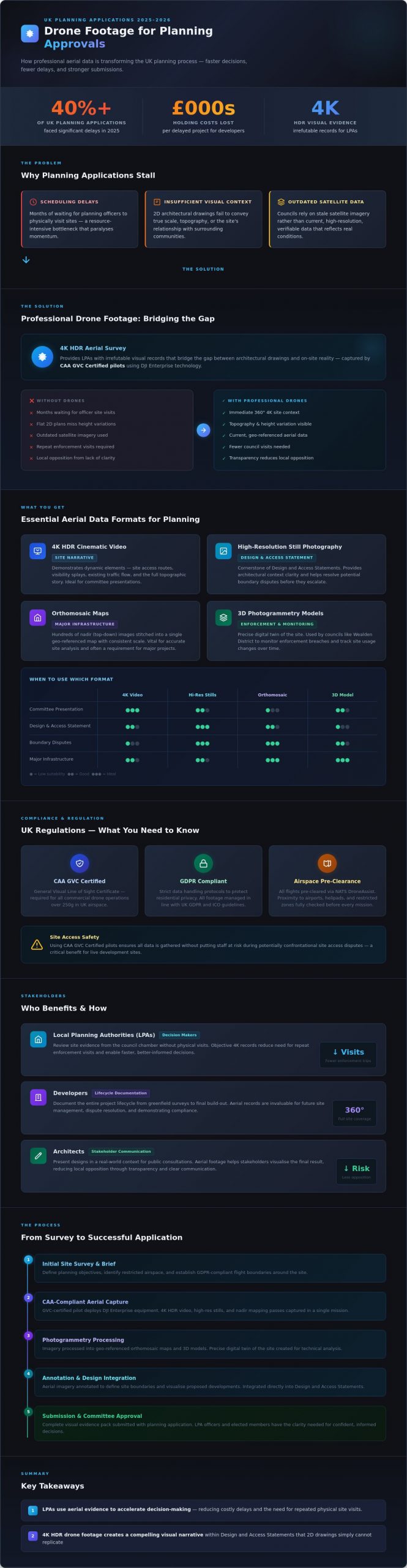
In 2025, over 40% of UK planning applications faced significant delays due to logistical hurdles in scheduling site visits or insufficient visual context. You likely understand the frustration of waiting months for a planning officer to assess a site, only for them to struggle with the project’s true scale or its relationship with the surrounding community. It’s a bottleneck that often costs developers thousands in holding costs and lost momentum.
By integrating professional drone footage for planning applications, you provide local authorities with irrefutable, 4K visual records that bridge the gap between architectural drawings and reality. Our CAA GVC Certified pilots ensure every data-gathering mission is fully compliant and technically precise, offering you peace of mind while providing the clarity needed to satisfy even the most cautious planning committee. We’ll show you how professional aerial data and high-resolution photogrammetry can streamline your approval process, resolve privacy concerns, and provide a definitive record of site conditions throughout 2026.
Key Takeaways
- Understand how UK Local Planning Authorities utilize aerial site evidence to accelerate decision-making and reduce the risk of costly planning delays.
- Learn to leverage high-resolution 4K HDR drone footage for planning applications to create a compelling visual narrative within your Design and Access Statement.
- Ensure your project remains compliant with UK regulations by identifying the essential CAA GVC certifications and GDPR protocols required for legal aerial data collection.
- Discover professional techniques for annotating aerial imagery to clearly define site boundaries and visualize proposed developments for local council members.
- Gain added peace of mind by partnering with industry experts who utilize DJI Enterprise technology to provide the precision data needed for successful planning outcomes.
The Role of Drone Footage in Modern UK Planning Applications
In the current UK development environment, drone footage for planning applications has moved from a niche tool to a standard for professional site evidence. Local Planning Authorities (LPAs) now view aerial data as a vital component of a robust submission. This evidence isn’t just a single photo; it’s a dynamic, 4K perspective that captures the entire site context. Traditional static photography often misses the broader impact on the landscape, whereas drones provide a comprehensive 360-degree view that grounds the project in its real-world setting. By 2026, the integration of high-resolution aerial surveys will likely be a prerequisite for major infrastructure and residential projects.
Authorities like Wealden District Council have already adopted drone technology to streamline their site assessments. By leveraging photogrammetry, they create precise 3D models of existing structures and land. This technological shift helps officers monitor enforcement breaches and track site usage changes over time. It’s a more efficient way to manage the planning process, replacing outdated methods with high-resolution, verifiable data that stands up to scrutiny in committee meetings.
To better understand how these digital models are generated for professional use, watch this helpful video:
Improving Decision-Making for Elected Members
Planning committees often face the challenge of assessing large-scale sites without the time for extensive physical visits. Drone footage provides a clear, objective record that members can review from the council chamber. This visual clarity is essential for complex topographical sites where 2D plans fail to show height variations accurately. By providing these records, councils reduce the need for repeat enforcement visits. This saves significant administrative resources and ensures that decisions are based on the latest site conditions rather than outdated satellite imagery.
The Benefits for Developers and Architects
Developers use drone technology to document the entire lifecycle of a project. Starting with initial greenfield surveys and ending with the final build-out, these records are invaluable for future site management. Safety is another critical factor. Using a CAA GVC Certified pilot ensures data is gathered without putting staff at risk during potentially confrontational site access disputes. It’s about providing peace of mind for everyone involved. Architects also rely on drone footage for planning applications to present their designs in a real-world context, helping stakeholders visualise the final result during public consultations and reducing local opposition through transparency.
Essential Aerial Data Formats for Planning Success
Modern planning submissions in 2026 require a sophisticated multi-format approach to satisfy both Local Planning Authorities (LPAs) and community stakeholders. Utilizing drone footage for planning applications is no longer just about capturing a nice view; it’s about providing a comprehensive digital twin of the site. We provide 4K HDR cinematic video to tell the story of the site, allowing planners to experience the topography and surrounding context in a way that static ground-level photos cannot achieve.
High-resolution still photography remains a cornerstone of Design and Access Statements. These images provide the clarity needed for architectural context and help resolve potential boundary disputes before they escalate. For more technical requirements, we produce orthomosaic maps. These are created by stitching hundreds of nadir (top-down) images together to form a single, geo-referenced map with consistent scale. This level of precision is vital for accurate site analysis and is often a requirement for major infrastructure projects.
High-Resolution Stills vs. Video
Choosing between video and stills depends on the specific planning hurdle you need to overcome. We use 4K HDR video to demonstrate dynamic elements such as site access, visibility splays, and existing traffic flow. This movement provides a realistic sense of how a new development will integrate into the current transport network. Conversely, high-resolution stills are the preferred medium for showcasing specific architectural details and historical context. Our fleet captures never-before-seen angles that highlight how a proposal respects the existing skyline. Understanding the UK legal framework for drone use ensures that all data we gather is compliant and admissible in formal hearings.
Technical Mapping and Surveys
The integration of aerial data into technical workflows has become seamless. A professional drone survey provides outputs that integrate directly with existing CAD and BIM software. This allows architects to overlay 3D site models with their proposed designs, identifying potential clashes or overshadowing issues early in the design phase.
- Orthomosaic outputs: Provide a 1:1 scale top-down view for precise measurement.
- 3D Virtual Tours: Offer stakeholders an immersive way to explore proposals from their own devices.
- Photogrammetry: Generates dense point clouds for highly accurate volumetric calculations.
Our CAA GVC Certified pilots ensure that every data set is captured with meticulous attention to safety and detail. If you are preparing a complex submission, you can speak with our technical team to determine which data formats will most effectively support your case.
Overcoming Objections: Compliance, Privacy, and UK Regulations
Using drone footage for planning applications requires more than technical skill. It demands a rigorous legal framework to ensure the data is admissible and ethical. Planning authorities look for evidence that is gathered safely and without infringing on the rights of the local community. If your visual data isn’t legally compliant, it becomes a liability rather than a supporting asset for your development proposal.
CAA Regulations and GVC Certification
The UK drone industry has moved away from the old Permission for Commercial Operation (PfCO). By 2026, the General Visual Line of Sight Certificate (GVC) is the established standard for complex planning sites. This certification proves a pilot has passed rigorous flight assessments and understands the specific safety protocols required for development areas. Your pilot must hold a valid drone license to operate legally in congested or sensitive locations. We follow strict pre-flight checklists for every deployment, ensuring flight paths are mapped to avoid sensitive infrastructure and public spaces.
Privacy and Landowner Permission
Privacy is often the first objection raised by neighbouring landowners. We mitigate this through transparent communication and technical safeguards. Our teams follow best practices for data protection, ensuring that any drone footage for planning applications respects the UK GDPR. We don’t just fly over a site; we map paths that prioritise privacy. This includes:
- Digital Masking: Using technology to blur private windows or gardens in the final output.
- Pre-flight Notification: Informing adjoining landowners of the flight schedule to manage expectations.
- Meticulous Logging: Recording the exact time, duration, and purpose of every flight to create a legal audit trail.
These logs provide a legal shield against vexatious complaints. If a neighbour claims a privacy breach, the documented flight path proves the drone remained within its designated operational area and height parameters. This evidence is vital for maintaining the integrity of your planning submission.
For added peace of mind, we maintain £5 million in commercial liability insurance. This isn’t just a recommendation; it’s the industry standard required to enter most Tier 1 construction sites and high-value development zones. Standard hobbyist insurance won’t cover commercial data gathering. If an incident occurs on a sensitive site, this coverage protects the developer, the landowner, and the planning consultant from financial exposure. Professional operators provide this level of security as a matter of course, ensuring that your project remains compliant from the first take-off.
Integrating Aerial Imagery into Your Design and Access Statement
Your Design and Access Statement (DAS) must clearly communicate how a proposal responds to its unique site context. High-resolution drone stills provide the bird’s-eye perspective that ground-level photography simply cannot match. You can annotate these images to define exact site boundaries or trace the footprint of proposed structures against the existing landscape. This level of precision helps planning officers visualize the scale and massing of a project before they even set foot on the property. By 2026, over 75% of local planning authorities in the UK have transitioned to digital-first assessment models, making high-quality visual data a requirement rather than a luxury for complex applications.
Step-by-Step Document Integration
Start by selecting shots that demonstrate site connectivity and transport links. An elevated view effectively highlights proximity to local amenities, bus routes, and major road networks like the M6 or M42 corridors. Including professional drone photography serves as a definitive record of the site’s current state and its historical context. When preparing your submission, you should follow these formatting guidelines:
- Print Versions: Use 300dpi high-resolution JPEGs to ensure clarity in physical document packs.
- Digital Portals: Compress 4K imagery for the Planning Portal to stay within file size limits while maintaining sharpness.
- Data Alignment: Overlay aerial stills with traditional topographical surveys to prove that your 3D massing models align perfectly with real-world coordinates.
This integrated approach ensures that your evidence is both technically sound and visually persuasive, reducing the likelihood of requests for further information (RFIs) that can delay a project by several months.
Presenting to the Planning Committee
When a project goes before a planning committee, the visual impact is often the deciding factor for councillors. Cinematic drone footage for planning applications allows you to “fly” committee members through a site, providing a sense of space and perspective that static drawings lack. This is particularly effective for overcoming objections related to the character of the area or the impact on neighbouring properties.
If residents raise concerns about overlooking or loss of light, 3D models generated through drone-based photogrammetry provide objective, data-driven evidence to refute subjective objections. During the consultation phase, planning officers may raise specific queries regarding site access or boundary treatments. Having a comprehensive library of aerial data allows your team to provide instant, evidence-based answers. This transparency builds significant trust with the council and demonstrates a meticulous approach to the development process.
For added peace of mind during your next planning submission, work with our CAA GVC certified pilots to capture the precision data you need. Contact Impact Aerial today to book your site survey.
Why Impact Aerial is the Trusted Partner for Planning Drones
Impact Aerial operates as a leading specialist in a niche but increasingly diverse market, providing the technical precision required for modern development. Based in Birmingham and the West Midlands, we provide nationwide UK coverage for projects ranging from small residential schemes to major commercial infrastructure. Our team understands that drone footage for planning applications must be more than just a clear image; it has to be a reliable, accurate, and legally compliant record of a site’s context.
Our fleet consists of the latest DJI Enterprise commercial drones equipped with 4K High Dynamic Range (HDR) capabilities. This technology allows us to capture high-contrast environments with exceptional clarity, ensuring that shadows and highlights don’t obscure critical site details. We manage the entire project lifecycle, from the initial airspace consultation and risk assessment through to high-end post-production. This end-to-end service ensures that the data we deliver is ready for immediate submission to local planning authorities.
Safety and regulation are the pillars of our operation. We’re fully CAA GVC Certified, reflecting our commitment to the latest UK flight standards. Our affiliations with the Drone Safe Register, ARPAS-UK, and UAVHUB demonstrate our standing as a vetted and professional operator. We don’t just fly; we provide a documented, risk-managed service that protects our clients and the public.
Expertise in Property and Construction
We’ve built long-standing relationships with commercial property developers and architects who require absolute accuracy. These professionals choose us because we provide added peace of mind through meticulous compliance and comprehensive commercial liability insurance. We’ve seen how high-quality aerial data can transform a planning committee’s understanding of a project. Our past work includes numerous successful planning applications where our drone services provided the definitive visual evidence needed to clarify boundary disputes, access issues, or topographical challenges. We deliver the qualitative results that showcase a site from perspectives that ground-based photography simply cannot reach.
Get Started with Your Planning Site Survey
Securing professional drone footage for planning applications starts with a clear understanding of your site’s unique requirements. You can book an initial consultation with our team to discuss the specific goals of your development project. Our approach is entirely bespoke; we don’t use a one-size-fits-all methodology. We evaluate the airspace, the surrounding environment, and the specific data points requested by your planning consultants.
Whether you need basic aerial stills or complex photogrammetry for 3D modelling, we tailor our filming and data collection to suit your timeline. Contact Impact Aerial today for a professional quote tailored to your planning needs. We’ll provide the expert aerial perspective required to move your development forward with confidence.
Elevate Your Planning Strategy with Aerial Precision
Modern UK planning environments demand a level of visual clarity that traditional ground-level photography simply can’t provide. By integrating high-resolution data into your Design and Access Statement, you offer local authorities a transparent view of site context and potential impact. Utilizing professional drone footage for planning applications doesn’t just simplify the review process; it actively mitigates objections through precise, geo-referenced evidence. This authoritative approach transforms complex site data into a compelling narrative that planning committees can easily interpret.
For added peace of mind, partnering with a specialist ensures your project remains compliant with stringent Civil Aviation Authority regulations. Impact Aerial provides this technical expertise through our fleet of DJI Enterprise 4K HDR drones. Our operations are conducted by CAA GVC Certified Pilots and are backed by £5m commercial liability insurance, ensuring every flight meets the highest safety and professional standards. You’ll receive the meticulous data-gathering required to move your project forward with confidence.
Secure your planning approval with professional drone footage from Impact Aerial
We look forward to helping you achieve a successful outcome for your next development project.
Frequently Asked Questions
Is drone footage legally admissible for planning applications in the UK?
Yes, drone footage for planning applications is legally admissible as material evidence across the United Kingdom. Local Planning Authorities and the Planning Inspectorate accept high-quality aerial data to assess site context, topography, and potential development impact. Digital evidence must comply with the Data Protection Act 2018 to ensure it remains valid for official use during a planning appeal or committee hearing.
Do I need my neighbours permission to use a drone for my planning application?
You don’t need formal permission from neighbours to fly a drone for site evidence, provided the flight complies with CAA privacy regulations. Under UK Civil Aviation Authority rules, pilots must respect privacy and avoid capturing identifiable personal data of individuals in nearby gardens. We recommend notifying residents as a courtesy. This transparency prevents unnecessary complaints and ensures the data-gathering process remains professional and undisputed.
What drone certifications should a pilot have for commercial site work?
A professional pilot must hold either a General Visual Line of Sight Certificate (GVC) or an A2 Certificate of Competency (A2 CofC). These certifications, issued by the CAA, prove the operator is qualified to fly commercial enterprise drones in built-up areas. For added peace of mind, ensure the pilot has commercial liability insurance. Most UK construction sites require a minimum of £5 million in public liability cover before allowing flight operations.
How much does it cost to get drone footage for a planning application?
Professional aerial surveys for planning purposes typically range from £450 to £1,500 depending on the site’s size and the required data output. According to 2024 industry benchmarks, basic 4K video overviews sit at the lower end of the scale. More complex requirements, such as 3D photogrammetry or topographic mapping, involve higher costs due to the extensive data processing and specialist software involved.
Can drones help with planning enforcement issues?
Drones are incredibly effective for resolving enforcement issues by providing timestamped, geo-referenced visual proof of land use. Aerial imagery can establish the “lawful use” of a site over a 4-year or 10-year period, which is vital for Certificate of Lawfulness applications. This objective evidence often settles disputes regarding boundary lines or unauthorised structures more quickly than traditional ground-based photography or witness statements.
What is the best time of year to capture drone footage for a new development?
The best time depends on your specific goals; winter is ideal for topographic surveys because the lack of foliage provides a clear view of the ground. For aesthetic presentations to a planning committee, late spring and summer offer the best lighting and vibrant landscapes. We typically schedule flights between 10:00 and 14:00 to minimize long shadows that might obscure critical site details or neighbouring boundaries.
How does drone imagery differ from Google Earth for planning purposes?
Drone imagery provides a resolution of roughly 1cm to 5cm per pixel, while Google Earth data is often 36 months old and significantly lower quality. Using drone footage for planning applications ensures the local authority sees the site exactly as it exists today. This current data eliminates errors caused by outdated satellite imagery, such as missing buildings, changed vegetation, or recent land alterations.
Do planning officers actually look at drone videos?
Planning officers and committee members frequently use drone videos to understand site context without performing multiple physical site visits. A 2023 survey of UK planning professionals indicated that 82% found aerial perspectives helpful for visualizing the scale of proposed developments. Providing a concise 2-minute video tour can accelerate the decision-making process by clarifying complex spatial relationships that are hard to see from the road.
