
UK Commercial Real Estate: 2026 Drone Photography Guide

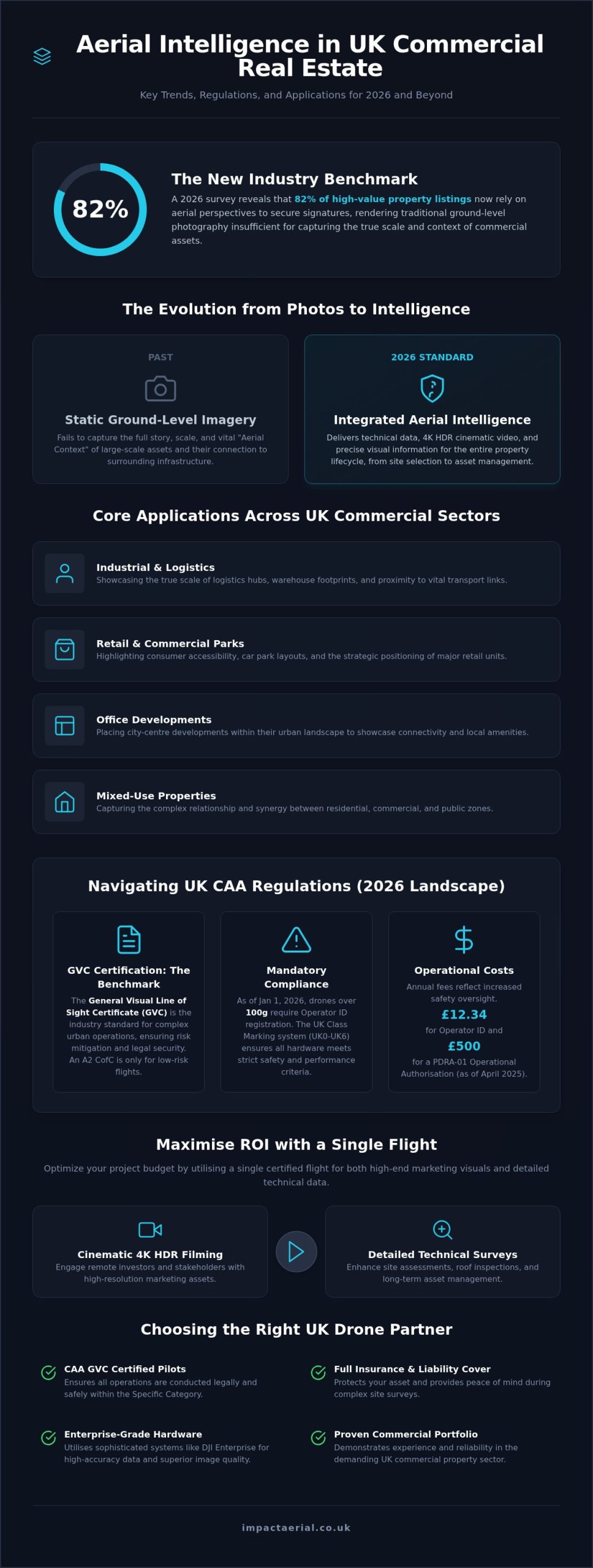
A recent 2026 survey revealed that 82% of high-value property listings now rely on aerial perspectives to secure signatures, a trend that’s rapidly becoming the baseline for the industrial and retail sectors. You’ve likely found that static, ground-level imagery fails to capture the true scale of a multi-unit logistics hub or the strategic connectivity of a major retail park. However, integrating drone photography for commercial real estate UK wide involves more than just a camera in the air. It requires navigating dense urban flight paths and adhering to strict CAA safety protocols to mitigate operational risk.

We recognize the pressure to accelerate sales while managing the safety concerns and inconsistent quality that often come with uncertified operators. This guide provides the clarity you need to use professional aerial data for faster transactions and more accurate asset management. You’ll learn about the latest GVC certification requirements, the impact of the 2026 drone class marking system, and how fully insured, technical specialists provide the peace of mind required for complex site surveys. We’ll show you how to turn high-tier aerial data into a powerful tool for your commercial property portfolio.

Key Takeaways

  • Understand the 2026 regulatory landscape and why CAA GVC certification is now the industry benchmark for complex urban property operations.
  • Discover how professional drone photography for commercial real estate UK integrates high-end marketing visuals with technical data for faster site assessments.
  • Learn how to optimize your project budget by utilizing a single flight for both cinematic 4K HDR filming and detailed roof or site surveys.
  • Explore the shift from basic aerial shots to integrated aerial intelligence that enhances construction monitoring and long-term asset management.
  • Identify the essential hardware standards and portfolio benchmarks required to choose a reliable technical partner in the UK commercial sector.

The Evolution of Aerial Photography in Commercial Real Estate

The history of aerial photography has transitioned from simple observation to the sophisticated DJI Enterprise systems used in modern property management. In the 2026 UK market, drone photography for commercial real estate UK represents a definitive shift toward “aerial intelligence.” This means we don’t just provide photos; we deliver technical data that informs the entire property lifecycle. High-stakes transactions now require a level of visual precision that only 4K HDR imagery can provide.

This technology is applied across several core UK sectors:

  • Industrial: Showcasing the scale of logistics hubs and warehouse footprints.
  • Retail: Highlighting car park layouts and accessibility for consumers.
  • Office: Placing city-centre developments within their urban landscape.
  • Mixed-Use: Capturing the complex relationship between residential and commercial zones.

Why Traditional Photography is No Longer Sufficient

Ground-based photography often fails to capture the full story of a large-scale asset. For a 500,000 sq ft industrial park, a standard camera can’t show how the site interacts with local transport links. Aerial views provide the essential context of surrounding infrastructure, which is vital for logistics-heavy businesses. We define “Aerial Context” as the visual relationship between a property and its local geography. This perspective is crucial for identifying site boundaries and understanding the proximity to major arterial roads or rail networks. For professionals seeking these same high standards in the US market, Flight Time Media specializes in real estate photography and videography across the Twin Cities.

The 2026 Standard for Professional Visuals

In 2026, 4K cinematic video is the gold standard for engaging remote investors and international stakeholders. These high-resolution assets allow for detailed digital zooming, enabling off-site teams to inspect site conditions with meticulous clarity. It’s vital that your aerial content matches the branding and quality of your ground-based photography to maintain a professional digital portfolio. By utilizing enterprise-grade hardware, we ensure that every frame of your drone photography for commercial real estate UK project meets the rigorous standards of the modern property market. This technical approach builds trust and provides the reassurance that your asset is being represented with absolute accuracy.

Technical Standards and CAA Compliance for UK Drone Operations

Operating a drone in the UK’s commercial sector requires strict adherence to Civil Aviation Authority (CAA) regulations. As of January 1, 2026, the regulatory environment has become more stringent, with the mandatory registration weight threshold lowered to 100g. This means almost every professional aircraft used for drone photography for commercial real estate UK must have a valid Operator ID, which currently carries an annual fee of £12.34. The introduction of the UK class marking system (UK0 to UK6) ensures that hardware meets specific safety and performance criteria before takeoff.

For commercial real estate projects, the distinction between the Open and Specific operational categories is critical. While an A2 Certificate of Competency (A2 CofC) allows for some low-risk flights, most professional work in congested urban environments like London or Birmingham requires a General Visual Line of Sight Certificate (GVC). A GVC allows pilots to apply for an Operational Authorisation, a necessity for flying closer to people and buildings than the standard rules permit. As of April 2025, the fee for a PDRA-01 Operational Authorisation stands at £500 per year, reflecting the increased administrative and safety oversight required for complex missions.

The Importance of GVC Certification

GVC certification is the industry benchmark for complex property surveys. It demonstrates that a pilot has undergone rigorous theoretical and practical testing, specifically focusing on risk mitigation in built-up areas. Hiring a certified professional isn’t just about image quality; it’s about legal security. Unlicensed operations can result in heavy fines and the invalidation of your project’s data. All Impact Aerial pilots are fully CAA GVC certified, ensuring that every flight is conducted within the legal framework of the Specific category.

Insurance and Liability: Protecting Your Asset

Insurance isn’t optional. It protects your interests. While hobbyists might fly for fun, professional drone photography for commercial real estate UK requires robust commercial liability insurance. We maintain £5m in commercial liability coverage as standard. This protects your asset, third-party property, and public safety during every mission. We also handle all necessary airspace notifications and flight permissions. This removes the administrative burden from your team. If you’re planning a project in a high-risk urban zone, you can request a technical safety consultation to ensure your site is covered.
UK Commercial Real Estate: 2026 Drone Photography Guide

Strategic Applications: From Site Selection to Sale

By 2026, the integration of drones into the property lifecycle has shifted from a marketing extra to a fundamental technical requirement. Aerial intelligence now guides every stage of the process, from initial land surveys and topographic data collection to the final marketing of a completed asset. These data-rich perspectives allow developers to identify site constraints early, often saving significant time and resources during the groundwork phase. High-resolution imagery also plays a pivotal role in planning applications, providing an objective view of how a development integrates with existing transport links and green spaces.

During the build, construction site monitoring provides a chronological record of progress. By using consistent aerial overlays, project managers can track milestones and share visual updates with off-site stakeholders. When presenting these findings to local authorities or investors, following UK Civil Aviation Authority drone regulations ensures that your data is compliant and your operations are fully insured. This level of professionalism is essential for securing planning permissions and maintaining stakeholder trust through transparent reporting.

Industrial and Logistics: Capturing Scale

The massive scale of modern logistics hubs requires a perspective that ground-based photography simply cannot provide. Utilizing drone photography for commercial real estate UK enables agents to showcase warehouse footprints, loading bays, and yard space in a single, comprehensive frame. These wide-angle views are critical for highlighting a property’s proximity to major UK motorways and rail hubs, which are key selling points for logistics tenants. For more information on how we collect this technical data, read our Drone Survey guide. Showcasing these assets isn’t just about the visual; it’s about demonstrating operational efficiency to potential occupiers.

Retail and Office: Selling the Experience

Maximising ROI: Integrating Marketing with Technical Surveys

In the competitive 2026 property market, achieving a high return on investment requires a more integrated approach to aerial data. Many firms still treat marketing imagery and technical surveys as separate silos, which often leads to redundant site visits and inflated costs. By consolidating these requirements into a single flight operation, you can capture high-resolution visual assets for your sales brochures while simultaneously gathering the technical data needed for structural roof inspections or site surveys.

This four-step workflow ensures maximum efficiency from every deployment:

  • Step 1: Conduct a single flight for dual-purpose data and visual capture, reducing the logistical burden on site managers.
  • Step 2: Utilize high-res imagery for both marketing brochures and detailed roof inspections, providing value to both the sales and maintenance departments.
  • Step 3: Leverage professional post-production to create distinct assets, such as cinematic clips for investors and technical reports for engineers.
  • Step 4: Distribute the tailored content across digital platforms, including LinkedIn and dedicated property portals, to maximize exposure.

Dual-Purpose Flights: Efficiency in Action

A marketing-focused shoot for drone photography for commercial real estate UK can easily double as a preliminary drone property survey. During the same flight window, our pilots capture the 4K HDR footage required for cinematic reels while also documenting the condition of gutters, HVAC systems, and roofing membranes. This technical overlap significantly reduces site visit costs and minimizes the operational downtime associated with multiple drone deployments. To understand the full scope of these integrated capabilities, you can read our Drone Services guide. By capturing technical data during the visual shoot, you provide your asset management team with actionable intelligence without increasing the project budget.

Post-Production: Turning Raw Data into Narrative

The true value of drone photography for commercial real estate UK is realized during the post-production phase. We use 4K HDR editing to ensure that raw footage is transformed into professional-grade marketing assets that stand out on high-traffic property portals. Adding dynamic graphics and callouts to aerial footage allows you to highlight key features, such as net internal area or specific access points, directly within the video. Creating immersive virtual tours also provides a 24/7 “open house” experience, which is particularly effective for engaging international buyers who cannot visit the site in person. If you’re ready to enhance your property’s digital presence, you can book a post-production consultation to discuss your specific branding requirements.

Choosing the Right Drone Partner in the UK

Selecting a provider for drone photography for commercial real estate UK requires a shift in focus from creative flair to technical compliance. While many operators offer aerial services, the commercial sector demands a partner who understands the complexities of industrial sites and urban retail environments. You should prioritize firms that utilize DJI Enterprise grade hardware; these systems are designed for the rigors of professional work, offering superior stability and 4K HDR visual data that consumer models cannot match. This hardware ensures that the final output meets the high-tier quality expected by international investors and stakeholders.

Always scrutinize a potential partner’s portfolio for specific commercial experience. A pilot who specializes in weddings or landscapes may lack the operational knowledge required to navigate a congested construction site or a high-traffic logistics hub. Meticulous flight planning and risk assessment are the hallmarks of a professional specialist. Before hiring, use this essential checklist to verify their credentials:

  • CAA GVC Certification: The essential benchmark for 2026 legal compliance in congested areas.
  • £5m Commercial Liability Insurance: The industry standard for protecting your assets and third-party property.
  • Enterprise-Grade Hardware: Ensuring high-end output, reliability, and advanced safety features.
  • Post-Production Capability: The ability to turn raw 4K footage into cinematic marketing assets or technical survey reports.

Impact Aerial: Professionalism and Precision

We maintain a safety-first approach to every project, ensuring full adherence to the latest CAA protocols and risk mitigation strategies. Our Birmingham-based headquarters provides a strategic advantage for West Midlands projects while allowing for rapid, national UK-wide deployment. By utilizing DJI Enterprise 4K HDR drones, we provide the precision required for both marketing visuals and technical surveys. This meticulousness, combined with our £5m liability coverage, provides the reassurance that your property portfolio is in expert hands.

Next Steps for Your Property Portfolio

Moving from a conceptual project to final delivery involves a structured and methodical workflow. It begins with meticulous flight planning and airspace clearance, followed by the on-site capture of 4K HDR assets. Our team then manages the post-production phase to ensure your content is ready for immediate distribution across digital portals. If you’re ready to integrate professional drone photography for commercial real estate UK into your marketing or asset management strategy, you can Request a professional drone photography quote from Impact Aerial to begin your initial consultation.

Advancing Your Property Strategy with Aerial Intelligence

The transition from simple imagery to integrated aerial intelligence is now a fundamental requirement for the UK property market. By leveraging dual-purpose flights, you can secure high-resolution marketing assets while simultaneously fulfilling technical survey requirements. This approach doesn’t just save time; it provides a comprehensive data set that informs every stage of the property lifecycle. Navigating the 2026 regulatory landscape requires a partner who prioritizes safety and compliance through formal certification.

Integrating professional drone photography for commercial real estate UK ensures your assets are represented with the precision remote investors expect. We offer a meticulous service backed by CAA GVC certified pilots, £5m commercial liability insurance, and the latest DJI Enterprise 4K HDR technology. This combination of expertise and high-end hardware provides the reassurance you need for complex urban operations.

Ready to elevate your digital property portfolio? You can Contact Impact Aerial for a Professional Commercial Drone Quote to discuss your specific site requirements. We look forward to helping you accelerate your transactions with professional aerial data.

Frequently Asked Questions

Do I need special permission to fly a drone over a commercial property in the UK?

You need the land owner’s permission for takeoff and landing. For commercial flights in congested areas, pilots must adhere to specific CAA regulations. If your property is located within restricted airspace, we must obtain specific ATC clearance before the flight. We manage all flight planning and airspace notifications as part of our service to ensure your project remains fully compliant with UK aviation law.

What is the difference between a standard drone pilot and a GVC certified one?

A GVC (General Visual Line of Sight Certificate) certified pilot has completed advanced theoretical and practical assessments required for complex operations. Unlike the basic A2 CofC, a GVC is the prerequisite for an Operational Authorisation from the CAA. This allows us to operate enterprise-grade drones in urban environments where standard distance rules are too restrictive for professional commercial property work.

How much does drone photography for commercial real estate cost?

Project costs vary based on the site’s scale, the complexity of the airspace, and specific data requirements. Factors like thermal sensor use and the level of post-production editing also influence the final investment. We provide bespoke pricing for drone photography for commercial real estate UK to ensure you receive a tailored package that meets your specific marketing and surveying needs without unnecessary overheads.

Can drones fly in rain or high winds during a property shoot?

While DJI Enterprise drones feature robust wind resistance, we don’t fly in heavy rain or winds exceeding 20mph. Precipitation can degrade image quality and potentially damage sensitive electronic components. We monitor regional weather forecasts meticulously and will proactively reschedule your session if conditions threaten the safety of the aircraft or the precision of the 4K HDR visual data we provide.

How long does a typical commercial drone photography session take?

A standard session for a single commercial asset typically takes between two and four hours on-site. This timeframe includes the mandatory pre-flight safety assessment, hardware setup, and the actual capture of aerial stills and cinematic video. Larger industrial hubs or mixed-use developments may require a full day or multiple site visits to ensure we document every technical data point required for your stakeholders.

What insurance should a professional drone company have in the UK?

Professional drone companies must carry specialist commercial liability insurance compliant with EC 785/2004 standards. We maintain £5m in commercial liability insurance to protect our clients, the public, and third-party property during every mission. It’s vital to verify this coverage, as standard public liability insurance often excludes aviation risks. This insurance provides the necessary reassurance when operating drones in complex or high-value environments.

Can drones be used for internal commercial property photography?

Drones are excellent for internal filming in large warehouse units or expansive office lobbies. We use specialized, smaller aircraft equipped with 360-degree propeller guards to ensure safety within confined spaces. This technique provides a unique perspective on the net internal area and structural features. Internal flights require a pilot with significant manual flight experience to safely navigate around lighting fixtures and interior structural elements.

How soon will I receive the edited aerial photos and videos?

Final delivery times depend on the complexity of the project. We usually provide raw previews within 24 hours of the flight. The fully edited 4K HDR videos and high-resolution stills are typically delivered within three to five working days. This allows our post-production team to add technical graphics and branding, ensuring your drone photography for commercial real estate UK assets are ready for immediate use.
Professional Drone Services in the West Midlands: The 2026 Commercial Guide

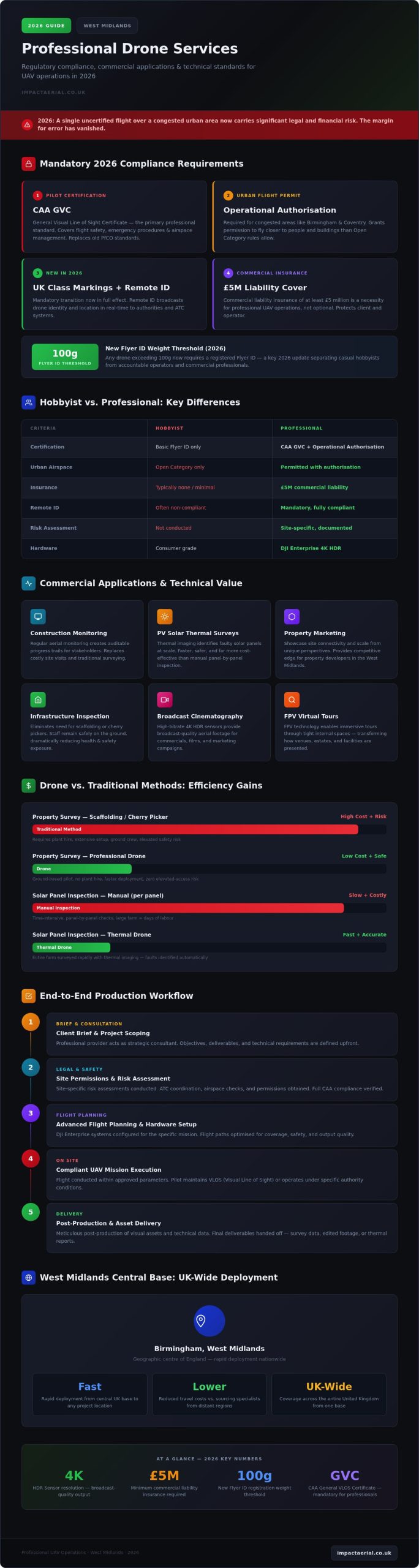
In 2026, the margin for error in aerial operations has vanished; a single uncertified flight over a congested Birmingham street now carries significant legal and financial risks that many project managers don’t fully realise. As the UK transition to mandatory UK class markings and Remote ID takes full effect, the distinction between a hobbyist with a camera and professional drone services West Midlands companies can legally hire has never been more critical. You likely recognise the immense value of high-resolution 4K HDR data for surveys or marketing, yet the fear of regulatory blowback or safety incidents often stalls ambitious projects.

We’re here to bridge that gap by providing a definitive roadmap for professional UAV operations this year. You’ll learn how to master the complex landscape of 2026 regulations, from the new 100g Flyer ID threshold to the necessity of £5m commercial liability insurance. This guide explores the technical applications that make drone technology a cost-effective alternative to traditional filming, ensuring your next project is both cinematically stunning and meticulously compliant.

Key Takeaways

  • Understand how professional drone services West Midlands providers navigate the complex urban airspace of Birmingham using end-to-end project management.
  • Identify mandatory 2026 safety standards, specifically the CAA GVC and the requirement for Operational Authorisation in congested urban hubs.
  • Explore high-value technical applications, including construction site monitoring, PV solar farm thermal surveys, and high-resolution virtual tour creation.
  • Learn how a structured production workflow manages site permissions and risk assessments to ensure full regulatory compliance on every flight.
  • Discover the logistical benefits of a central West Midlands base for rapid, cost-effective deployment across the United Kingdom.

The Scope of Professional Drone Services in the West Midlands

Professional drone services West Midlands teams provide have transitioned from simple aerial photography into comprehensive data management systems. In 2026, these operations manage the entire lifecycle of visual assets and technical data. A professional provider acts as a strategic consultant, handling the intricate legalities and safety protocols required for complex urban environments like Birmingham city centre. This partnership ensures every mission is compliant with the Civil Aviation Authority (CAA) while meeting specific commercial objectives. It isn’t just about flying; it’s about precision.

Modern aerial operations require a structured workflow that encompasses site-specific risk assessments and meticulous post-production. Whether you’re commissioning a technical survey or a high-end marketing film, the provider manages the “headache-free” logistics so your team can focus on core tasks. By integrating advanced flight planning with high-spec hardware, professional services deliver a level of precision that consumer equipment cannot match.

To see how these aerial systems support regional safety and infrastructure, watch this overview from the West Midlands Fire Service:

The Evolution of UAV Technology for Business

The industry has moved decisively toward DJI Enterprise platforms, which offer the reliability needed for high-stakes commercial work. High-bitrate 4K HDR sensors now provide the clarity required for broadcast-quality cinematography and detailed inspections. FPV (First Person View) technology is also changing how we create immersive commercial tours by allowing drones to move fluidly through tight internal spaces. These tools support a wide range of commercial applications of drones, providing both aesthetic and technical value without the limitations of older hardware.

Economic Benefits for West Midlands Industries

For regional industries, the financial benefits are clear. Using a drone for a property survey is far more efficient than traditional plant hire like scaffolding or cherry pickers. It keeps staff safely on the ground, significantly lowering health and safety risks during infrastructure checks. Construction firms use regular aerial monitoring to maintain an auditable trail of progress for stakeholders. Property developers also gain a competitive edge by showcasing the connectivity and scale of their West Midlands sites from unique perspectives that ground-based assets cannot replicate.

Regulatory Compliance: The 2026 Standard for West Midlands Pilots

Operating a commercial UAV in 2026 requires a sophisticated understanding of the UK’s evolving aviation laws. For any business commissioning drone services West Midlands wide, the legal landscape has shifted towards stricter accountability and clear technical benchmarks. The primary standard for professional pilots is now the CAA GVC (General Visual Line of Sight Certificate). This qualification demonstrates a pilot’s competency in flight safety, emergency procedures, and airspace management, moving beyond the basic flyer IDs used by hobbyists.

Compliance isn’t just about the pilot’s skills; it’s about the specific permissions granted by the regulator. In congested urban environments like Birmingham or Coventry, standard flight rules often aren’t enough. Professional operators must hold an Operational Authorisation from the CAA to fly closer to people and buildings than the “Open Category” allows. This document is a critical safety barrier that ensures urban missions are conducted without endangering the public or local infrastructure.

Navigating CAA GVC and Operational Authorisation

The transition from the old PfCO standards to the current GVC requirements reflects a more rigorous approach to urban flight. Professional pilots manage complex permissions in restricted West Midlands airspace by coordinating with Air Traffic Control and monitoring local restrictions. If you’re unsure which category your project falls into, understanding the requirements for a valid drone license is the first step toward a legal and successful operation.

Risk Assessment and Safety Protocols

Every professional flight begins long before the propellers spin. A meticulous pre-flight process involves site surveys, weather monitoring, and checking NOTAMs (Notices to Air Missions) for temporary airspace restrictions. This technical preparation aligns with the latest Civil Aviation Authority drone guidance, ensuring that data privacy and public safety are never compromised. In high-traffic commercial environments, these protocols are the only way to mitigate risk effectively.

Risk mitigation also extends to financial protection. All commercial drone work in the UK legally requires third-party insurance that complies with EC 785/2004. We maintain £5m commercial liability insurance as a non-negotiable standard. This high level of coverage provides psychological comfort to our clients, ensuring they aren’t exposed to liability should an unforeseen incident occur. When you prioritise these regulatory benchmarks, you ensure your project stays on the right side of the law. If you need assistance verifying the compliance of your next site, our team can help you assess your specific regulatory needs.

Professional Drone Services in the West Midlands: The 2026 Commercial Guide

Commercial Applications: From Marketing to Technical Data

Professional drone services West Midlands teams provide now deliver a sophisticated dual-stream output: high-impact cinematic production and precision technical data. This integration is a cornerstone of the expanding commercial drone use in the UK, where aerial platforms act as both creative assets and critical survey instruments. By utilizing 4K HDR sensors, we capture “hero” shots for brand campaigns while simultaneously providing the high-bitrate footage required for detailed infrastructure assessments. This versatility allows businesses to extract maximum value from a single deployment.

Property and Real Estate Visuals

In the competitive West Midlands commercial market, capturing the scale and connectivity of an estate is vital. Aerial imagery highlights strategic transport links, such as proximity to major motorway networks or regional rail hubs, providing context that ground-based photography lacks. Implementing professional drone photography is a proven method for accelerating commercial enquiries; it allows prospective tenants and investors to grasp the full layout of a development instantly. Beyond static images, we create immersive virtual tours that facilitate remote stakeholder engagement, ensuring that project milestones are visible to decision-makers regardless of their location.

Drones in Construction and Infrastructure

Construction site monitoring has evolved into a mandatory requirement for modern project management. Regular aerial filming provides an auditable visual trail of progress, serving as both a PR tool and essential health and safety documentation. Instead of relying on manual inspections that require scaffolding or cherry pickers, drones allow for the safe assessment of roofs and complex structures. This data-centric approach integrates seamlessly into wider drone survey workflows, where 4K video assets are used to identify structural anomalies or thermal leaks in PV solar farms.

For infrastructure projects, time-lapse aerial filming offers long-term documentation that is invaluable for stakeholder reporting. By capturing consistent perspectives over several months, we provide a clear narrative of the project’s evolution. This level of technical oversight ensures that potential issues are identified early, reducing the risk of costly delays and enhancing the overall ROI of the construction phase. By choosing a partner who understands both the aesthetic and technical requirements, you ensure that your data is both accurate and persuasive.

The End-to-End Production Process: From Brief to Delivery

Hiring drone services West Midlands teams shouldn’t feel like a gamble. A professional operation functions as a technical consultancy, managing every variable from the initial brief to the final export. This process begins with a consultation to define your creative goals and technical requirements while assessing legal feasibility. We don’t just ask what you want to see; we determine what’s legally permissible under 2026 CAA regulations. This meticulous approach ensures that your project is built on a foundation of safety and compliance from day one.

Once feasibility is confirmed, the pre-production phase handles the logistical heavy lifting. This includes managing site permissions, conducting detailed risk assessments, and issuing local authority notifications. For projects in dense urban hubs like Birmingham, we coordinate with local councils and the police to ensure operations in public spaces, such as those near Birmingham New Street, don’t disrupt the community. This “headache-free” management is what separates a professional consultant from a basic operator.

Planning for Success in the West Midlands

Operating in the heart of the UK requires a sophisticated understanding of the local environment. We manage the “weather window” through constant monitoring and contingency planning, ensuring that your project stays on track despite the unpredictable UK climate. Every aerial filming drone deployment follows a site-specific safety brief. This isn’t just a formality; it’s a vital requirement for maintaining our £5m commercial liability coverage and protecting your business from legal exposure. On-site execution is carried out using commercial-grade DJI Enterprise hardware, which provides the reliability and data security that professional projects demand.

Post-Production and Technical Delivery

The value of a professional service is often defined in the editing suite. Raw data is transformed into polished commercial assets through 4K HDR colour grading, sound design, and professional editing. For technical clients, we can add data overlays, branding, and graphics to survey videos, making complex information easy for stakeholders to digest. This ensures that the final product isn’t just a video file, but a functional business tool; to see how these assets can help your company scale globally, check out KDB EMPIRE LTD.

Selecting the right partner for drone services West Midlands goes beyond simple proximity. While many operators position themselves as local pilots for hire, a professional partner offers a technical consultancy that leverages the West Midlands as a strategic central hub for national operations. This geographic advantage translates into tangible benefits for clients, including reduced travel overheads and a centralised logistics model that ensures consistent data quality across multiple UK project sites. By choosing a provider with a central base, you gain a partner capable of rapid deployment while maintaining a single, authoritative point of contact for complex project management.

Before commissioning any aerial work, conducting thorough due diligence is essential to protect your business from legal liability. You should always verify a provider’s current Operational Authorisation and request up-to-date insurance documents. A professional operation won’t hesitate to provide these credentials. It’s also vital to review their portfolio to ensure they have specific experience in your commercial sector, whether that involves high-end cinematography or technical infrastructure surveys. This verification process ensures that the team on your site possesses the expertise to handle the sophisticated DJI Enterprise hardware required for 2026 standards.

The Strategic Advantage of a Birmingham Hub

A Birmingham-based hub provides a unique logistical edge for national infrastructure and construction projects. We offer rapid response times for construction monitoring and urgent survey requirements that out-of-region providers often struggle to match. Our pilots possess a deep, localized understanding of West Midlands airspace and specific flight restrictions, allowing us to navigate complex urban corridors with precision. For organisations with assets spread across the country, this central location acts as a pivot point. It enables efficient deployment to any corner of the United Kingdom while ensuring that safety protocols and data delivery formats remain uniform across every site.

Impact Aerial: Precision and Compliance

Our operation is built on a commitment to the highest safety standards and meticulously managed risk mitigation. We maintain £5m commercial liability insurance as our baseline standard, providing the reassurance that corporate stakeholders and legal teams demand in 2026. We specialise in bridging the gap between creative vision and technical data requirements, ensuring that every asset we deliver serves a clear business purpose. Our CAA GVC certified pilots are trained to handle the “headache-free” management of site permissions and local authority notifications, removing the regulatory burden from your team.

Taking the next step in your project is straightforward. You can secure professional oversight and high-tier visual assets by booking an initial consultation for drone services in 2026. This technical review will define your creative goals, verify legal feasibility, and ensure your site operations are fully compliant and optimized for maximum ROI. We’re ready to help you master the landscape of professional UAV operations from our central West Midlands hub.

Securing the Future of Your Aerial Projects

Professional drone services West Midlands providers now offer a critical blend of technical precision and regulatory expertise. As we move through 2026, the transition to stricter CAA standards means that hiring uncertified operators is no longer a viable risk for any commercial enterprise. By choosing a partner with a central Birmingham hub, you ensure rapid deployment and consistent quality across your entire UK portfolio. Whether you’re capturing high-resolution marketing assets or conducting complex infrastructure surveys, the right equipment and certification are non-negotiable requirements for success.

Our team utilizes DJI Enterprise 4K HDR equipment and operates with CAA GVC certified pilots to deliver results that meet the highest professional standards. We back every mission with £5m commercial liability insurance, providing the technical reassurance your stakeholders require for urban and industrial operations. You can request a bespoke quote for your West Midlands drone project to begin defining your project’s technical and creative requirements. We look forward to helping you transform your perspective and elevate your commercial data this year.

Frequently Asked Questions

Do I need a special permit for drone filming in Birmingham city centre?

Yes, flying in Birmingham city centre typically requires an Operational Authorisation from the Civil Aviation Authority (CAA) because it is a congested urban area. Professional drone services West Midlands providers handle these complex permissions by liaising with local councils and West Midlands Police. We manage the entire application process, ensuring that flights over high-traffic zones like the Bullring or New Street are conducted legally and safely without disrupting the public.

What is the difference between CAA GVC and A2 CofC certifications?

The CAA GVC (General Visual Line of Sight Certificate) is the mandatory professional standard for complex commercial operations in the Specific category, such as urban filming. In contrast, the A2 CofC is a basic competency for lighter drones in the Open category. For high-stakes projects in the West Midlands, the GVC is preferred as it allows for the Operational Authorisation required to fly commercial-grade hardware closer to people and buildings.

How much does professional drone hire cost in the West Midlands?

Professional drone hire costs vary based on the project’s technical complexity, location, and required outputs. Factors such as the need for specialized thermal sensors for solar farm surveys or high-end post-production for virtual tours will influence the final quote. We provide bespoke pricing tailored to your specific goals, ensuring you receive a transparent breakdown that includes flight planning, regulatory compliance management, and the delivery of high-resolution 4K HDR assets.

Can drones fly in the rain or high winds in the UK?

Flight feasibility depends strictly on the hardware’s technical specifications and safety thresholds. While DJI Enterprise drones offer enhanced stability, we typically don’t fly in heavy rain or winds exceeding 22mph to ensure the safety of the airframe and the quality of the data. Our pilots monitor live weather telemetry and maintain a weather window strategy, providing contingency dates to ensure your project is captured under optimal conditions for visual clarity.

What insurance should a professional drone operator carry?

A professional operator must carry third-party liability insurance that is fully compliant with EC 785/2004 regulations. This is a legal requirement for all drone services West Midlands companies provide. We maintain £5m in commercial liability coverage to protect our clients from unforeseen risks. This high level of insurance is a hallmark of a vetted specialist and provides essential financial reassurance when operating near high-value infrastructure or in busy urban hubs.

How long does a typical aerial video shoot take to complete?

The duration of an aerial shoot depends on the scope of the brief and the size of the site. A standard commercial property survey or marketing session typically takes between two and four hours on-site. More complex projects, such as large-scale construction site monitoring or detailed thermal surveys of solar farms, may require a full day of flight operations to capture all necessary data points and ensure comprehensive coverage for post-production.

Do you provide raw drone footage or only fully edited videos?

We offer both raw 4K HDR footage and fully edited commercial assets depending on your internal requirements. Many clients prefer our end-to-end post-production services, which include professional colour grading, sound design, and the integration of technical data overlays. However, if you have an in-house creative team, we can provide the high-bitrate raw files immediately after the shoot, ensuring you have the flexible source material needed for your own marketing or survey workflows.

Are drones safe for indoor filming in commercial spaces?

Drones are highly effective for indoor filming in large commercial spaces like warehouses, factories, or retail atria. We utilize specialized hardware, including FPV drones with protective prop guards, to navigate tight internal environments safely. This approach is ideal for creating immersive virtual tours that showcase the scale and layout of a facility. Every indoor mission includes a specific internal risk assessment to manage obstacles and ensure the safety of staff and property.