
What Equipment is Used for Drone Surveys? A Professional UK Guide

Can a standard consumer drone deliver the centimetre-level accuracy required for a major UK infrastructure project, or is it merely an expensive toy risking a significant construction error? You aren’t alone if you feel confused about the technical divide between retail gadgets and enterprise-grade systems. Understanding exactly what equipment is used for drone surveys is the first step toward mitigating risk and ensuring your data meets professional industry standards.

We understand that navigating the 2026 UK drone regulations, including new UK class marks and Remote ID requirements, adds another layer of complexity to your decision-making process. This guide provides a definitive checklist of the hardware, sensors, and software required to produce high-tier aerial data. You’ll learn the critical differences between standard GPS and RTK technology, the role of specialized sensors like LiDAR, and the processing software that turns raw imagery into BIM-ready assets. By the end, you will have the technical insight needed to select a certified drone service provider that prioritizes precision, compliance, and operational safety.

Key Takeaways

  • Learn how to select the optimal UAV platform, comparing the agility of multirotors with the endurance of fixed-wing drones for large-scale site coverage.
  • Understand why specialized sensors with global shutters and high resolution are essential for technical surveys, far exceeding the capabilities of standard 4K cameras.
  • Discover what equipment is used for drone surveys to achieve centimetre-level accuracy, including the critical role of RTK and GNSS hardware in correcting satellite data.
  • Gain insights into the high-performance computing hardware and photogrammetry software required to process thousands of aerial images into actionable, BIM-ready data.
  • Identify the mandatory safety and regulatory equipment required by the CAA to ensure your operations remain compliant and risk-mitigated on professional work sites.

Selecting the Right UAV Platform: Multirotor vs. Fixed-Wing

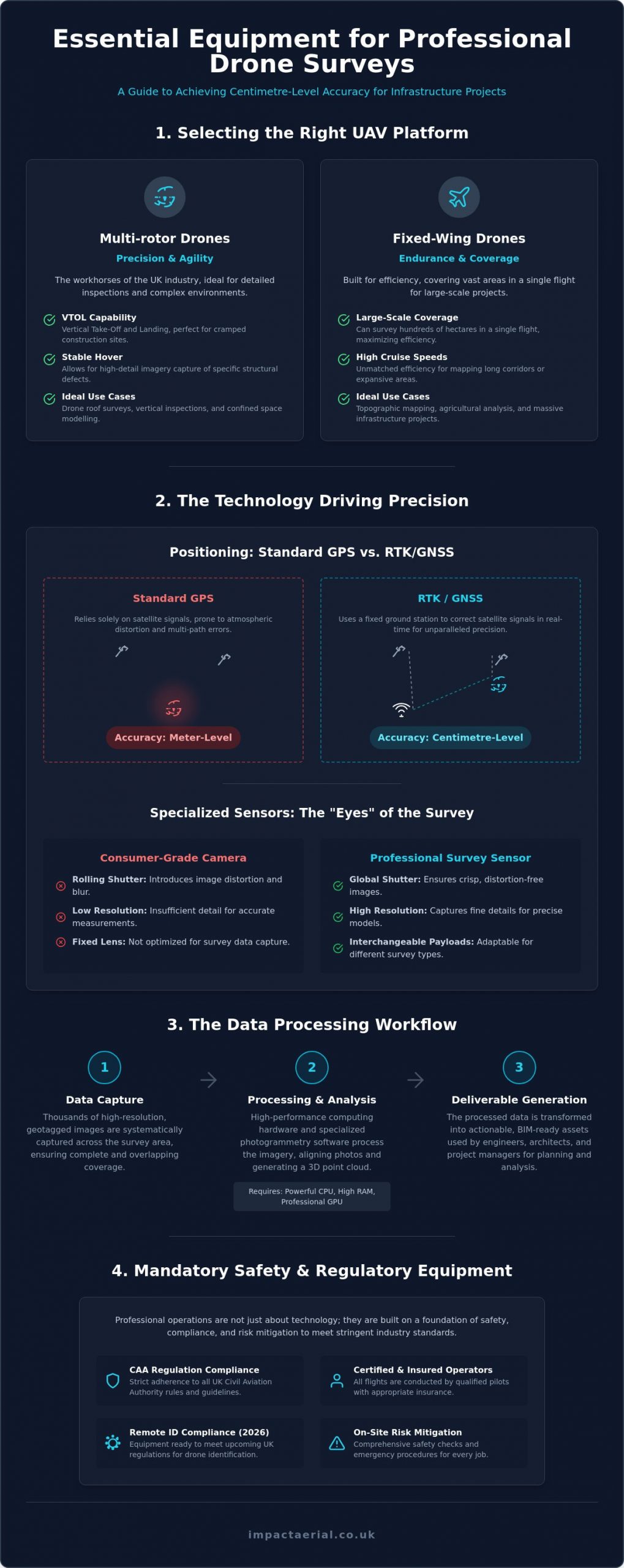
The term “platform” in the context of professional aerial work refers to the aircraft itself. It acts as the primary carrier for the sophisticated sensors required to generate accurate maps and models. When evaluating what equipment is used for drone surveys, the platform choice is the most fundamental decision an operator makes. A survey drone is defined as a high-precision UAV designed specifically for repeatable data collection. This ensures that every flight produces consistent results, allowing for precise temporal comparisons across different stages of a construction or environmental project.

Professional operators across the UK typically rely on DJI Enterprise drones because of their proven reliability and modular payload options. The choice of airframe depends heavily on the specific geography of the site, the required flight duration, and the total weight of the sensors being deployed. Payload weight isn’t just about the camera; it includes batteries, transmission systems, and mandatory safety hardware. This selection process is a core component of a professional unmanned aerial photogrammetric survey, where the stability of the platform directly influences the quality of the final data set.

To better understand how these platforms integrate into a professional workflow, watch this helpful video:

Multi-rotor Drones for Precision and Vertical Inspection

Multi-rotor aircraft are the workhorses of the UK drone industry. Their ability to hover with absolute stability makes them ideal for drone roof surveys and detailed inspections of confined spaces. Because they utilize Vertical Take-Off and Landing (VTOL) technology, they’re perfect for cramped UK construction sites where space is at a premium. The high-detail imagery captured during a hover allows engineers to identify specific structural defects that a moving aircraft might miss. Most UK firms utilize quadcopters like the Mavic 3 Enterprise for its portability or the Matrice 350 RTK for its ability to carry multiple heavy sensors simultaneously.

Fixed-Wing Drones for Large-Scale Land Mapping

While multi-rotors excel at detail, fixed-wing drones are built for endurance. These platforms can cover hundreds of hectares in a single flight, making them the preferred choice for large-scale uav land surveying and topographic mapping. Unlike their multi-rotor counterparts, they require more significant space for take-off and landing. Some models use a belly-land approach, while others have evolved to include VTOL rotors for vertical lift-off followed by horizontal flight. For massive infrastructure projects or expansive agricultural mapping, their efficiency and high cruise speeds are unmatched by traditional quadcopters.

Specialised Sensors: The “Eyes” of the Drone Survey

While the aircraft provides the means of transport, the sensors are the true workhorses of any aerial operation. They determine the resolution, accuracy, and technical utility of the collected data. Professional operators don’t rely on consumer-grade hardware; they use enterprise systems where payloads are often interchangeable to meet specific project requirements. When considering what equipment is used for drone surveys, the payload is often more important than the aircraft itself because it defines the quality of the final deliverable.

Sensor choice is dictated entirely by the specific output required, whether that’s a high-density 3D model, a topographic map, or a detailed heat map. These specialised tools allow us to capture data that exceeds the limitations of human vision and standard photography. If you’re unsure which technology fits your requirements, our experts can help you select the right aerial technology for your specific site needs.

High-Resolution RGB and Photogrammetry Sensors

Technical surveys require more than just a 4K video feed. High-resolution RGB sensors, typically featuring 1-inch CMOS sensors or larger, are the standard for professional photogrammetry. A critical distinction in identifying what equipment is used for drone surveys is the presence of a mechanical or global shutter. In consumer drones, “rolling shutters” capture images line-by-line, which causes significant geometric distortion when the drone moves at high speeds. Mechanical shutters eliminate this “jello effect,” ensuring every pixel is captured simultaneously. This precision is vital for creating high-density point clouds and accurate orthomosaics that engineers can trust for measurements.

Thermal Imaging and Multispectral Cameras

Beyond the visible spectrum, specialised sensors provide insights invisible to the naked eye. Radiometric thermal sensors are the primary tool for PV solar farm thermal surveys, where they detect minute temperature variances that indicate failing cells or electrical faults. These sensors don’t just “see” heat; they assign a specific temperature value to every pixel in the image. Similarly, multispectral sensors measure light reflection across several bands to assess plant health or environmental changes. Whether you’re identifying heat loss in a building envelope or monitoring crop stress, the choice of sensor ensures the data is both scientific and actionable.
What Equipment is Used for Drone Surveys? A Professional UK Guide

Ensuring Survey Accuracy: GNSS and Ground Control Equipment

Accuracy isn’t an optional extra in the professional survey industry; it’s the core requirement that separates a visual inspection from a technical-grade deliverable. Standard Global Positioning System (GPS) technology, the kind found in consumer smartphones and entry-level drones, typically has a horizontal margin of error between 3 and 5 metres. For a construction site or a topographic map, this level of discrepancy is unacceptable and could lead to catastrophic errors in volume calculations or boundary placements. When clients ask what equipment is used for drone surveys to ensure reliability, the answer lies in the Global Navigation Satellite System (GNSS) correction hardware.

Professional surveys rely on a meticulous combination of high-frequency onboard receivers and external ground-based reference points. This ecosystem allows operators to achieve centimetre-level precision, ensuring the data is verifiable and meets RICS or specific construction industry standards. You aren’t just capturing pictures; you’re recording precise spatial data points that must align perfectly with existing site plans and legal boundaries. This level of precision is what provides the psychological comfort and tangible business benefits our clients expect.

RTK and PPK Systems for Real-Time Precision

Real-Time Kinematic (RTK) systems represent a significant leap in aerial surveying efficiency. An RTK-enabled drone maintains a constant data link with a local base station or a network of reference stations to correct satellite signal errors in real-time. This is particularly effective for projects requiring immediate data validation on-site. Alternatively, Post-Processed Kinematic (PPK) technology records raw satellite data during the flight, which is then corrected against base station data after the drone lands. PPK is often the preferred choice in environments with challenging terrain or poor signal connectivity where a constant radio link is difficult to maintain. Both technologies are essential components when considering what equipment is used for drone surveys because they drastically reduce the need for extensive manual site marking.

Ground Control Points (GCPs) and AeroPoints

Despite the advancements in onboard correction, physical Ground Control Points (GCPs) remain a staple for absolute accuracy. These are high-contrast markers placed at surveyed coordinates across the project area, serving as “anchors” that tie the digital model to a specific coordinate system like the Ordnance Survey National Grid. Modern “Smart” GCPs, such as AeroPoints, have simplified this workflow. These devices integrate their own GNSS receivers to record their precise location autonomously. Using smart markers provides a redundant, verifiable check against the drone’s data, ensuring the final output is legally and technically robust for high-stakes engineering projects.

Data Processing Hardware and Software Solutions

The survey mission doesn’t end when the aircraft returns to its landing pad; in many ways, the most critical work is just beginning. Raw data is merely a collection of thousands of individual files that require structured transformation to become useful. When project managers ask what equipment is used for drone surveys, they must look beyond the flying hardware to the sophisticated computing environment on the ground. High-performance workstations equipped with enterprise-grade Graphics Processing Units (GPUs) are essential for stitching these vast 4K HDR datasets into a single, cohesive output. This local processing power ensures data security while handling the massive throughput required for high-tier quality.

Modern surveying requires that all aerial data is Building Information Modeling (BIM)-ready and compatible with existing Enterprise Resource Planning (ERP) systems. This integration allows stakeholders to move from a visual perspective to a data-centric decision-making process. If you need professional-grade data that integrates seamlessly with your existing workflow, book a consultation with our technical team to discuss your project requirements.

Photogrammetry and LiDAR Processing Software

Industry-standard software like Pix4D, DJI Terra, or DroneDeploy transforms 2D images into immersive 3D models and topographical maps. These platforms are the backbone of drone data collection surveys, enabling the generation of high-density point clouds that facilitate precise measurements. For sites with significant overgrowth, LiDAR processing software is used to filter active laser pulse data, allowing us to see through canopy layers to the true ground surface. This level of technical processing ensures that the final digital twin is a meticulous and faithful representation of reality.

Post-Production and Virtual Tour Creation Gear

Beyond technical mapping, professional virtual tour creation requires specialized editing gear and 360-degree stitching software. Impact Aerial utilizes professional post-production suites to refine imagery and add interactive data layers that provide clarity to stakeholders. This process involves high-end workstations capable of rendering complex interactive environments without losing resolution. This meticulous approach to data handling ensures that your project data is not just accurate, but also actionable and easy to navigate for all team members.

The Critical Role of Safety and Regulatory Equipment

Professional drone surveys in the UK operate under the strict oversight of the Civil Aviation Authority (CAA). While high-resolution sensors and RTK systems provide the data, a comprehensive suite of safety and site management tools ensures that every mission is conducted legally and without risk to persons or property. When assessing what equipment is used for drone surveys, the conversation must include the hardware that keeps the operation within its defined safety envelope. This meticulous approach to risk mitigation is what allows us to operate on active construction sites and near critical infrastructure with absolute confidence.

The specific hardware deployed on a site is often dictated by the pilot’s operational authorizations. For instance, a CAA GVC certification enables pilots to fly in more complex environments, provided they use aircraft with the appropriate safety redundancies and site control gear. These regulations ensure that the technology is matched by professional competency and rigorous operational standards, providing clients with the reassurance that their project is in expert hands.

Essential Safety Gear for CAA-Compliant Operations

Securing a flight area requires more than just a skilled pilot; it requires a suite of specialized ground equipment. Professional operators use digital anemometers to measure real-time wind speeds, ensuring conditions remain within the aircraft’s manufacturer-specified limits before and during flight. On the ground, fire-resistant LiPo battery bags and specialized transport cases are mandatory for the safe storage and handling of high-capacity power cells. To manage the site effectively, we utilize high-visibility clothing, clear site signage, and dedicated landing pads. These tools create a visible and secure operational zone, preventing unauthorized access and ensuring a controlled environment for every take-off and landing.

Enterprise vs. Consumer Hardware: Why It Matters

The technical gap between retail drones and enterprise survey systems is most apparent in their safety architecture. Professional-grade aircraft feature omnidirectional obstacle avoidance sensors that detect hazards in all directions, providing a critical layer of protection in complex urban or industrial environments. Many enterprise models also incorporate dual-battery systems. If one cell fails mid-flight, the secondary battery provides enough power for a safe, controlled descent rather than a catastrophic failure. Additionally, these systems use encrypted data transmission to ensure that sensitive site information remains secure and private. Understanding what equipment is used for drone surveys at this level helps clients recognize the value of choosing a specialist provider that prioritizes operational integrity and data security.

Elevate Your Project Precision with Professional Aerial Data

Professional drone surveying is a sophisticated ecosystem where aircraft, sensors, and ground control hardware must work in perfect unison. By moving beyond consumer-grade tools, you ensure that every data point is accurate, compliant, and ready for immediate integration into your BIM or CAD workflows. Understanding what equipment is used for drone surveys is a critical first step for any project manager who values precision and strict adherence to UK aviation standards.

At Impact Aerial, we provide the technical expertise and high-end hardware required to deliver centimetre-level accuracy. Our operations are led by CAA GVC Certified Pilots using DJI Enterprise Grade Equipment to ensure the highest tier of data quality. We further prioritize your site security with £5m Commercial Liability Insurance, offering the reassurance that your project is in safe, expert hands.

Get a Professional Drone Survey Quote from Impact Aerial

We look forward to helping you transform your site perspective with industry-leading aerial technology and meticulous data processing.

Frequently Asked Questions

Do I need different equipment for a roof survey versus a land survey?

Yes, the choice of aircraft typically shifts between multi-rotor drones for roof inspections and fixed-wing platforms for land surveys. Roof surveys require the hovering stability of a quadcopter to capture high-detail imagery of structural defects in confined spaces. Conversely, large-scale land surveys often utilize fixed-wing drones because they can cover hundreds of hectares in a single flight with greater efficiency.

What is the difference between a standard 4K drone and a survey drone?

A survey drone is a high-precision UAV designed for repeatable data collection, whereas a standard 4K drone is primarily built for visual aesthetics. Survey-grade hardware includes mechanical shutters to prevent image distortion and integrated RTK receivers for centimetre-level positioning. These technical features ensure that the resulting data is geometrically accurate and robust enough for engineering and construction applications.

How does RTK equipment improve the accuracy of a drone survey?

RTK equipment provides live corrections to satellite signals by communicating with a local base station or a network of reference stations. This process reduces the horizontal margin of error from several metres down to just 1 to 3 centimetres. It’s a fundamental part of what equipment is used for drone surveys to ensure digital models align perfectly with real-world site coordinates and legal boundaries.

Is specialised software required to view the results of a drone survey?

You don’t necessarily need specialized software to view final PDF reports or orthomosaic images, but professional GIS or CAD software is required to manipulate 3D models and point clouds. Most providers deliver data in industry-standard formats like .LAS, .OBJ, or GeoTIFF. These files are designed for seamless integration into BIM (Building Information Modeling) environments and common architectural or engineering design tools.

What safety equipment should a professional drone pilot have on-site?

A professional pilot must deploy site management tools including high-visibility clothing, landing pads, and “Drone Operations” signage to secure the take-off area. Technical safety gear includes anemometers for real-time wind speed monitoring and fire-resistant bags for LiPo battery storage. These items are mandatory for maintaining a CAA-compliant operational environment and mitigating risks to site personnel during every mission.

Can any drone be used for thermal surveys on solar farms?

No, thermal surveys require radiometric sensors that assign a specific temperature value to every pixel in the image. Standard thermal cameras might provide a visual heat map, but they lack the scientific precision needed to identify specific failing cells or electrical faults. Professional solar farm surveys utilize enterprise platforms capable of carrying high-resolution radiometric payloads to ensure the data is scientifically actionable.

Why is a mechanical shutter important for drone surveying equipment?

A mechanical shutter is vital because it captures the entire image simultaneously, eliminating the geometric distortion caused by moving aircraft. When evaluating what equipment is used for drone surveys, a global or mechanical shutter is a non-negotiable requirement for high-speed mapping. Without it, the resulting 3D models will contain significant measurement errors that compromise the integrity of the entire survey.

What equipment is used to process drone data into a 3D model?

Processing requires high-performance computing workstations equipped with powerful GPUs and specialized photogrammetry software like Pix4D or DJI Terra. This hardware-software combination stitches thousands of individual 2D images together into a cohesive 3D point cloud or digital twin. The process is computationally intensive, requiring significant RAM and processing speed to handle large 4K HDR datasets effectively after the flight is completed.
Creating a Digital Twin with Drone Data: The Professional UK Guide

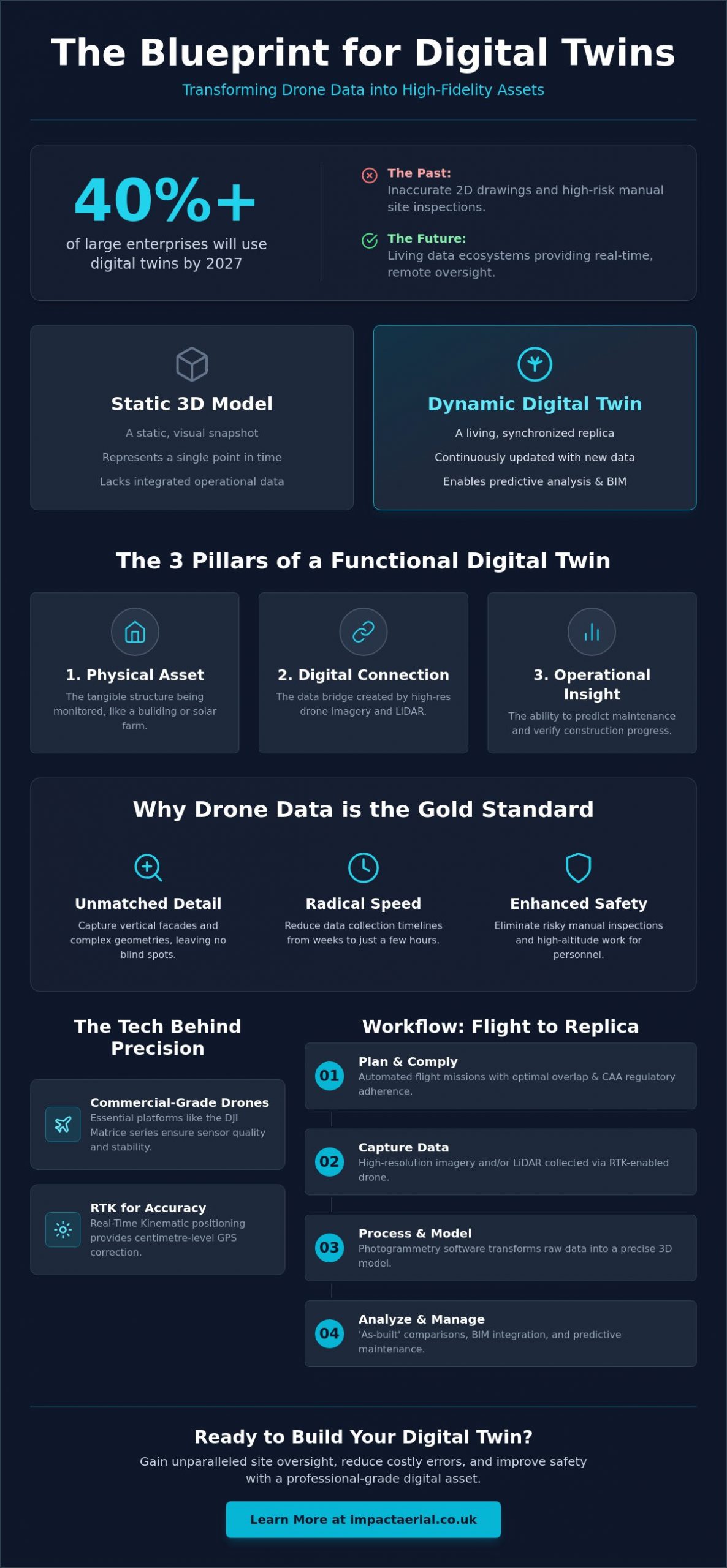
Over 40% of large enterprises are expected to use digital twins by 2027, according to MindInventory research. This represents a significant shift for UK project managers who are moving away from the limitations of inaccurate 2D drawings and the inherent risks of manual site inspections. Creating a digital twin with drone data isn’t just about capturing a 3D model; it’s about building a living, data-rich ecosystem that bridges the gap between field operations and the office. When executed with professional precision, these assets provide a level of site oversight that was previously impossible.

You likely recognize that traditional inspection methods are increasingly inefficient for complex modern structures. This guide will show you how to transform raw drone data into high-precision digital twins that drive predictive maintenance and construction efficiency. We’ll examine the technical workflows required for professional-grade output, the latest 2026 CAA compliance standards like Remote ID, and the specific hardware needed to move from basic site monitoring to a truly functional digital asset. By the end of this article, you’ll understand how to reduce site visit frequency and improve safety through remote, high-resolution monitoring.

Key Takeaways

  • Master the technical workflow for creating a digital twin with drone data, transforming static sites into dynamic, living assets for real-time remote monitoring.
  • Discover how to achieve centimetre-level accuracy using RTK (Real-Time Kinematic) positioning and commercial-grade enterprise hardware.
  • Learn to optimize data capture using specific overlap percentages and automated flight missions to ensure comprehensive 360-degree coverage of complex structures.
  • Understand how to leverage ‘as-built’ comparisons to identify construction errors early, significantly reducing the need for costly manual site inspections.
  • Gain insights into maintaining strict UK regulatory compliance through CAA GVC certification and robust risk mitigation protocols.

What is a Digital Twin and How Does it Differ from 3D Modelling?

Understanding the distinction between a standard 3D model and a functional digital twin is the first step toward modernizing asset management. While a 3D model provides a visual representation of a structure at a specific point in time, a digital twin acts as a synchronized virtual replica that mirrors the state of its physical counterpart. To understand the foundational concept of What is a Digital Twin, one must view it as a ‘living asset’ that evolves alongside the real-world project.

This evolution is achieved through the continuous integration of new information. In the context of creating a digital twin with drone data, this involves performing repeat flights and integrating sensor data to ensure the digital version remains accurate. Unlike static photogrammetry, which offers a frozen snapshot, a dynamic digital twin supports ongoing lifecycle management and Building Information Modelling (BIM) integration. This is now a standard requirement for major UK construction frameworks, providing a data-rich environment for stakeholders to collaborate.

To better understand this workflow and how it applies to complex infrastructure, watch this technical overview:

The Three Pillars of a Functional Digital Twin

  • Physical Asset: The tangible structure, such as a Birmingham commercial development or a regional solar farm, that requires monitoring.
  • Digital Connection: The data bridge established by high-resolution imagery and LiDAR, ensuring the virtual model reflects current reality through creating a digital twin with drone data.
  • Operational Insight: The ability to use the twin for predicting maintenance schedules or verifying that construction progress matches the original design specifications.

Why Drone Data is the Gold Standard for Digital Twins

Aerial platforms provide a level of detail that ground-based methods can’t match. Drones capture vertical facades and complex geometries that traditional surveying often misses, ensuring no blind spots in the digital replica. Speed is another critical factor; professional teams can reduce data collection timelines from several weeks to just a few hours. Most importantly, aerial data collection enhances safety. It eliminates the need for risky manual inspections involving scaffolding or rope access, keeping surveyors safely on the ground while the aircraft handles the high-altitude work.

Capturing High-Precision Drone Data: Hardware and Compliance

High-fidelity data acquisition starts with the right hardware. When creating a digital twin with drone data, consumer-grade equipment often lacks the sensor quality and positioning accuracy required for professional engineering standards. Commercial-grade platforms, such as the DJI Matrice 350 RTK or the Mavic 3 Enterprise, are essential. These drones provide the mechanical stability and high-resolution payloads needed to capture the sharp, undistorted imagery that forms the basis of a reliable digital asset.

Precision is governed by Real-Time Kinematic (RTK) positioning. This technology provides centimetre-level accuracy by correcting GPS data in real-time against a base station. While some surveyors still debate the use of traditional Ground Control Points (GCPs) versus RTK, professional UK workflows typically use a hybrid approach. This technical rigour ensures that the virtual model maintains a high-fidelity spatial relationship with the real world, aligning with the formal mathematical representation of a digital twin where data integrity is paramount.

Sensor Selection: Photogrammetry vs. LiDAR

  • Photogrammetry: This is the most cost-effective method for visual detail. It’s excellent for high-resolution textures and general site monitoring.
  • LiDAR: Essential for projects requiring penetration through dense vegetation or the capture of fine structural details like power lines and lattice towers.
  • Thermal Payloads: Integrating thermal data is vital for “living” twins of energy infrastructure. This allows for specialized PV solar farm thermal surveys that identify failing cells within a wider 3D ecosystem.

UK Regulatory Framework for Drone Data Collection

Compliance is a critical component of any professional survey. In the UK, the Civil Aviation Authority (CAA) categorizes flights into Open and Specific categories. Most commercial work in urban or congested environments requires a pilot with a General Visual Line of Sight Certificate (GVC). This certification proves the operator has the competency to manage risks in complex settings.

Asset owners should also verify that their drone partner carries at least £5m in commercial liability insurance. This level of coverage, combined with meticulous flight planning, provides the necessary reassurance when creating a digital twin with drone data on active construction sites or high-value commercial properties. Professional risk mitigation ensures that data collection is not only accurate but also fully legal and safe.

Creating a Digital Twin with Drone Data: The Professional UK Guide

The Step-by-Step Workflow: From Flight to 3D Replica

The transition from a physical structure to a high-fidelity digital replica is a structured process that demands technical precision at every stage. It begins with meticulous flight planning. To ensure the software can accurately calculate depth and geometry, we typically set a front overlap of 80% and a side overlap of 70%. For creating a digital twin with drone data of vertical structures, such as commercial facades or bridges, camera angles must be adjusted from standard nadir (top-down) views to oblique perspectives. This ensures that every vertical surface is captured with the same detail as the roofline.

Data capture is rarely a manual affair. Professional pilots execute automated grid missions for site-wide mapping and ‘orbit’ missions for individual assets. These pre-programmed flight paths ensure 360-degree coverage and eliminate the risk of missing critical data points. Once the flight is complete, the imagery is moved into a high-performance processing environment. Here, photogrammetry software stitches thousands of images together to form a dense point cloud. This point cloud is later converted into a 3D mesh and textured with high-resolution imagery to create a model ready for stakeholder review.

Optimising Data for Accuracy

Capturing images is only half the battle. Professional standards require consistent exposure and sharp focus across the entire dataset. Inconsistent lighting can lead to ‘ghosting’ or alignment errors during processing. We also focus heavily on filtering ‘noise’ from the point clouds. This involves removing temporary objects like moving vehicles or swaying vegetation that can distort structural lines. Finally, georeferencing ensures the model aligns perfectly with real-world coordinates, which is essential for any project requiring centimetre-level spatial integrity.

Software Platforms and Integration

A digital twin’s value lies in its utility. At Impact Aerial, we use industry-standard processing suites that allow for seamless integration into existing workflows. The data isn’t just a visual aid; it’s a functional tool that can be exported directly into CAD or Revit for engineering analysis. When creating a digital twin with drone data, we prioritize cross-device accessibility. This allows site teams in the field and remote stakeholders in the office to interact with the same ‘living’ asset in real-time, ensuring everyone is working from a single, accurate version of the truth. If you need a custom web platform to host and visualize these assets, you can check out Larasoft for bespoke software development.

Industry Applications: Where Digital Twins Drive ROI in 2026

The financial case for creating a digital twin with drone data is built on the mitigation of risk and the acceleration of project timelines. In the UK construction sector, “as-built” models are now routinely compared against “as-designed” BIM plans. This allows project managers to identify structural deviations or installation errors in real-time, preventing expensive remedial work later in the build cycle. By catching these discrepancies early, developers can avoid the compounding costs associated with delayed schedules and material waste.

In the West Midlands, regional infrastructure projects like motorway expansions and rail improvements benefit from regular drone data updates. These updates provide a chronological record of progress that ground teams can’t capture as efficiently. For the UK’s heritage sector, high-fidelity replicas of Grade I and II listed buildings are becoming essential for conservation. These twins allow architects to study delicate facades or inaccessible roof sections without the need for intrusive scaffolding, ensuring that restoration plans are based on precise, non-destructive data.

Predictive Maintenance and Asset Longevity

Digital twins move maintenance from a reactive model to a predictive one. By using historical data captured over several months or years, asset owners can track structural decay, masonry erosion, or corrosion over time. Integrating thermal payloads into the twin allows for the detection of moisture ingress or electrical hot spots that are invisible to the naked eye. This data-driven approach significantly reduces the “Total Cost of Ownership” by enabling targeted repairs rather than full-scale replacements, extending the life of the asset while ensuring occupant safety.

Stakeholder Collaboration and Communication

Complex projects involve multiple stakeholders who often need to review site conditions from remote locations. A digital twin provides an immersive 3D environment that’s perfect for board-level presentations or planning meetings with local authorities. These models also serve as powerful communication tools; virtual tours allow international investors to explore property assets with incredible detail without leaving their offices. For those looking to integrate these assets into a broader engagement strategy, our 3D Virtual Tours for Property guide explores these immersive techniques further.

If you’re ready to improve your project oversight and data accuracy, our specialists offer professional construction site monitoring services tailored to your specific site requirements.

Why Impact Aerial is Your Partner for Digital Twin Excellence

Impact Aerial provides a specialized approach to creating a digital twin with drone data, combining technical expertise with operational rigour. Based in Birmingham, our team is strategically positioned to deploy rapidly to sites across the UK, ensuring that your project data is captured during optimal weather windows. We don’t just provide imagery; we deliver a complete end-to-end service that begins with an in-depth technical consultation and concludes with advanced post-production. This methodical flow ensures that the final digital asset is fully optimized for your specific engineering or construction requirements.

Our operations are built on a foundation of safety and compliance. We hold full CAA GVC certification, which is the professional standard for operating in complex UK environments. To provide our clients with total peace of mind, we carry £5m in commercial liability insurance. This level of protection is essential for high-value assets and active construction zones. By utilizing the latest DJI Enterprise hardware, we set a benchmark for data precision that ensures every virtual model is a high-fidelity reflection of the physical asset, providing the reliability that technical consultants demand.

The Impact Aerial Difference: Precision and Safety

Our meticulous data collection protocols often exceed the standard drone survey requirements. We stay current with the evolving UK regulatory landscape, including the January 2026 mandates for Remote ID and UK class marks. This commitment to officialdom means your data is collected legally and ethically, protecting you from the regulatory risks associated with uncertified operators. Our expert post-production team then processes this raw information, turning it into actionable business intelligence that supports your specific lifecycle management goals and long-term asset monitoring.

Get Started with Your Digital Transformation

Every project has unique Key Performance Indicators (KPIs). We tailor our approach to creating a digital twin with drone data based on whether you require centimetre-level topographical accuracy or high-resolution thermal analysis for energy efficiency. Our onboarding process is structured to be seamless and informative. It starts with a comprehensive site risk assessment and flight planning phase, moving through to precision execution and final data delivery through your preferred software environment, such as Revit or CAD.

Request a professional drone data consultation from Impact Aerial today to learn how our technical consultants can help you reduce site visit frequency, improve safety, and enhance your overall operational efficiency through high-precision aerial data.

Advancing Your Digital Asset Strategy

Transitioning from static 3D models to dynamic, living replicas is a critical step for modern asset management. By creating a digital twin with drone data, you gain a high-fidelity environment that supports predictive maintenance and improves stakeholder communication across the project lifecycle. This shift doesn’t just enhance oversight; it fundamentally changes how you interact with your physical assets, moving from reactive repairs to data-driven operational decisions.

Professional execution is the only way to ensure these digital assets meet the rigorous standards required for UK construction and infrastructure. At Impact Aerial, we combine advanced DJI Enterprise hardware with meticulous data protocols to deliver centimetre-level accuracy. Our team provides the security you need through CAA GVC certified pilots and £5m in commercial liability insurance, ensuring every flight is compliant and every dataset is precise.

Your digital transformation starts with a specialized partner who understands both the technology and the regulatory landscape. Book Your Professional Drone Survey Consultation today to explore how we can integrate high-precision aerial data into your existing workflows. We look forward to helping you build a safer, more efficient future for your property portfolio.

Frequently Asked Questions

What is the difference between photogrammetry and a digital twin?

Photogrammetry is the specific technology used to extract 3D information from 2D photographs, while a digital twin is the comprehensive virtual replica itself. While photogrammetry provides a static visual model at a single point in time, a digital twin integrates ongoing data to reflect the current state of a physical asset. This distinction is vital for lifecycle management, as the digital twin serves as a functional tool for long-term monitoring rather than just a one-off visual record.

How accurate is drone data for creating 3D digital twins?

Professional-grade hardware equipped with Real-Time Kinematic (RTK) positioning achieves centimetre-level accuracy in the virtual model. This precision ensures that the twin aligns perfectly with real-world coordinates, which is essential for engineering and construction applications. Creating a digital twin with drone data at this level of fidelity allows for reliable comparisons between as-built structures and original design plans, providing the technical rigour required for high-stakes infrastructure projects.

Do I need a special UK drone license to create digital twins for my business?

Commercial operators typically require a General Visual Line of Sight Certificate (GVC) from the Civil Aviation Authority (CAA) for work in urban environments. While low-risk flights might fall under the Open category, most professional business applications involving digital twins require Specific category authorization. This ensures the pilot has undergone formal training in risk mitigation and flight safety, which is a legal prerequisite for operating drones commercially in congested UK areas.

What is the typical ROI for implementing drone digital twins in construction?

The primary return on investment comes from identifying construction errors early and reducing the need for manual site visits. By catching structural deviations before they become compounded issues, developers avoid expensive remedial work and project delays. Additionally, the ability to perform remote inspections significantly lowers the risk of on-site accidents and reduces the overhead costs associated with traditional surveying methods like scaffolding or high-access platforms.

Can drone digital twins be integrated with existing BIM software?

Professional drone data is fully compatible with industry-standard Building Information Modelling (BIM) software such as Revit and AutoCAD. The processed point clouds and 3D meshes can be exported in various formats, allowing for seamless integration into existing digital workflows. This allows project managers to overlay aerial data directly onto design plans, facilitating a more collaborative and accurate environment for architects, engineers, and site stakeholders to review progress in real-time.

How often should drone data be updated for a ‘living’ digital twin?

Update frequency depends entirely on the project’s pace and the specific goals of the asset owner. For active construction sites, weekly or bi-weekly flights are often necessary to track rapid progress and verify milestones. For long-term asset management of established buildings, quarterly or bi-annual updates might be sufficient. The “living” nature of the twin is maintained by ensuring that new data is captured whenever a significant physical change occurs to the asset.

What hardware is required for high-resolution digital twin capture?

High-resolution capture requires enterprise-grade drones such as the DJI Matrice 350 RTK or the Mavic 3 Enterprise. These platforms support high-megapixel sensors and specialized payloads, such as the Zenmuse P1 for photogrammetry or LiDAR sensors. Creating a digital twin with drone data at professional standards also necessitates robust processing hardware or cloud-based platforms capable of handling the massive datasets generated by thousands of high-resolution images across a single site.

Is it safer to use drones for digital twin creation than traditional methods?

Drones are significantly safer than traditional surveying methods because they eliminate the need for personnel to work at height. Manual inspections often involve scaffolding, rope access, or fragile roof walks, all of which carry inherent risks to life and limb. Aerial data collection allows surveyors to remain safely on the ground while the aircraft captures data from hazardous or inaccessible locations. This reduction in physical risk is a primary driver for drone adoption in the UK industrial sector.

Drone Mapping for Urban Planning: A Professional Guide to City Development in 2026

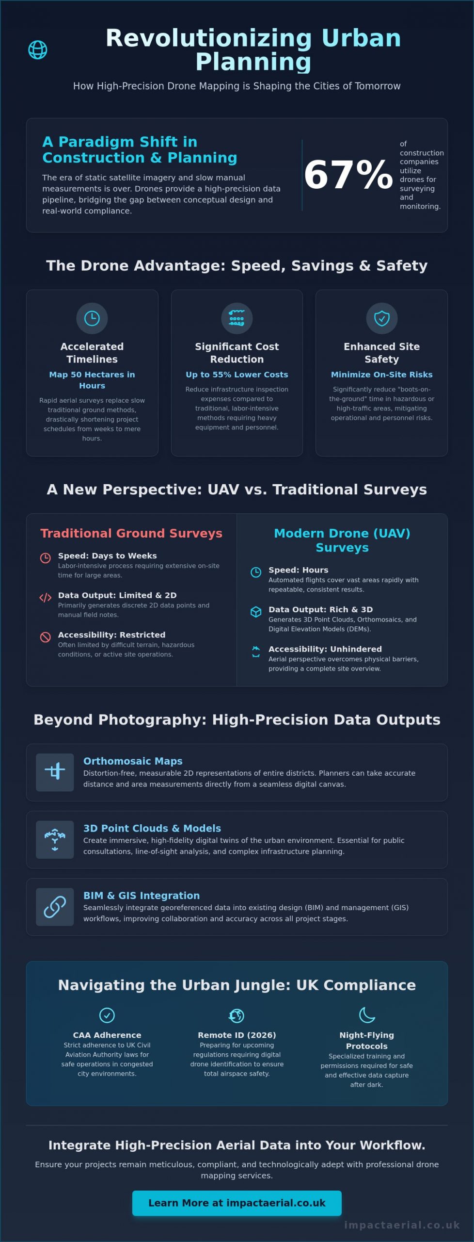
With 67% of construction companies now utilizing drones for site surveying and progress monitoring, the era of relying on static satellite imagery or slow manual measurements has officially ended. You likely feel the pressure of rapid urbanization and the need for faster project approvals while staying strictly compliant with the latest CAA regulations. Utilizing drone mapping for urban planning is no longer just about capturing aerial views; it’s a high-precision data pipeline that bridges the gap between conceptual design and real-world compliance.

Discover how high-precision aerial data accelerates urban development, ensures regulatory adherence, and provides the actionable insights needed for smarter city planning. This guide examines the technical requirements for survey-grade accuracy, including RTK and PPK capabilities, alongside the essential 2026 UK drone regulations like Remote ID and night-flying protocols. You’ll learn how to leverage highly accurate 3D models for public consultations and implement cost-effective site monitoring that can reduce infrastructure inspection expenses by up to 55%. We’ll provide the authoritative framework for integrating advanced aerial technology into your professional workflow, ensuring your projects remain meticulous, compliant, and technologically adept.

Key Takeaways

  • Accelerate project timelines by replacing traditional ground methods with rapid aerial surveys capable of mapping 50 hectares in just hours.
  • Utilize high-precision 3D point clouds and distortion-free orthomosaic maps to provide measurable data for complex urban infrastructure projects.
  • Ensure strict adherence to UK aviation law by understanding the specific certifications and safety protocols required for operations in congested city environments.
  • Improve collaboration across design teams by integrating georeferenced drone mapping for urban planning data into BIM and GIS workflows.
  • Optimize site monitoring and public consultations with actionable data that bridges the gap between conceptual design and regulatory approval.

Transforming Cityscapes: Why Drone Mapping is Essential for Modern Urban Planning

Drone mapping for urban planning is the sophisticated process of capturing georeferenced sensor data to produce high-resolution 2D and 3D outputs. Unlike traditional aerial survey methods, modern UAV technology provides a granular level of detail that satellite imagery simply cannot match. This shift is fundamental as cities move from reactive management to proactive, data-driven planning. By utilizing real-time data, developers and local authorities can make informed decisions based on current site conditions rather than outdated records.

To better understand how this technology integrates into the construction and planning phase, watch this helpful video:

In 2026, the pressures of rapid urbanization and stringent sustainability targets have made precision essential. Infrastructure is under constant strain. High-density city projects require a level of accuracy that ground-based teams struggle to provide within tight deadlines. While satellite imagery serves broad purposes, its resolution is often insufficient for the meticulous demands of modern city development. Drones bypass these limitations. They offer a reliable and cost-effective alternative for capturing site-specific information without the delays associated with orbital passes or cloud cover.

The Evolution of Urban Data Collection

The industry has transitioned from labor-intensive manual land surveys to automated UAV flight paths. These pre-programmed routes ensure consistent data coverage and repeatable results, which are vital for long-term monitoring. Modern hardware captures high-resolution 4K HDR imagery, revealing structural details and environmental factors that were previously invisible. This unique perspective provides a comprehensive overview of a site’s topography and existing assets. It allows ground teams to focus on specialized tasks rather than routine measurements.

Key Benefits for Stakeholders and Developers

One of the primary advantages of drone mapping for urban planning is the acceleration of the planning permission process. Providing local authorities with accurate, up-to-date site visualizations reduces ambiguity and speeds up approval cycles. Safety remains a paramount concern in any urban environment. By utilizing drones, developers can significantly reduce “boots-on-the-ground” time in hazardous or high-traffic areas, mitigating operational risks. Research indicates that using drones for infrastructure inspections can lead to a 55% cost reduction compared to traditional methods.

Public engagement has also seen a significant transformation. Stakeholders can now interact with immersive 3D city models that clearly illustrate the impact of proposed developments. These models provide a transparent and accessible way for the public to understand changes to their environment. This fosters trust and leads to smoother consultation phases. Through meticulous data processing, these surveys become a cornerstone of successful city development projects.

Beyond Photography: High-Precision Outputs for Urban Infrastructure

While high-resolution imagery is a staple of modern city development, the true value of drone mapping for urban planning lies in the technical datasets generated during the post-production phase. Professional UAV operations produce orthomosaic maps, which are distortion-free, measurable 2D representations of entire districts. These maps allow planners to take accurate distance and area measurements directly from their screens. By stitching together thousands of georeferenced images, we create a seamless digital canvas that serves as a reliable foundation for site analysis.

Precision goes deeper than 2D imagery. 3D point clouds generate millions of individual data points, creating a high-density digital replica of urban structures. These models allow for precise volumetric analysis and the creation of digital twins. A digital twin acts as a virtual testing ground where planners can stress-test designs against environmental factors before any ground is broken. This level of drone data for urban planning ensures that every decision is backed by empirical evidence rather than estimates.

Topographical and Volumetric Analysis

Accurate elevation data is critical for assessing drainage and flood risks in built-up areas. Using advanced drone survey techniques, teams can calculate earthworks and stockpiles with high precision. The Ground Sample Distance (GSD) determines the level of detail; a lower GSD means higher resolution and better accuracy for urban mapping. Even underground utility corridors can be identified through surface-level indicators captured in high-definition, providing a clearer picture of existing site constraints.

3D Visualisation and Public Consultation

Raw data becomes a powerful communication tool when transformed into interactive models. During community planning meetings, these 3D visualisations help stakeholders grasp the scale and impact of a project. Planners can simulate “rights to light” scenarios and identify potential view-path obstructions with surgical accuracy. For a more immersive approach, developers often use virtual tour experiences to showcase proposed developments to investors and the public. If you need to document every stage of your project’s lifecycle, our commercial drone services provide the ongoing data required for meticulous oversight.

Drone Mapping for Urban Planning: A Professional Guide to City Development in 2026

Data Accuracy and Efficiency: Comparing UAV Surveys to Traditional Methods

Traditional land surveying has long been the standard for city development, yet it often struggles to keep pace with the rapid requirements of 2026. Implementing drone mapping for urban planning allows for rapid data acquisition without the logistical bottlenecks of traditional ground-based surveying. While a manual ground crew might spend weeks traversing a complex site, a professional UAV can map 50 hectares in just a few hours. This speed doesn’t sacrifice quality; it provides a comprehensive dataset that is immediately ready for analysis.

Operational costs are significantly reduced by removing the need for heavy equipment. Traditional methods often require extensive scaffolding or disruptive road closures to gain necessary vantage points in high-density areas. Drones eliminate these overheads by operating from the air, maintaining safety while keeping surveyors out of active construction zones or high-traffic corridors. This approach ensures that your project remains on schedule without compromising the safety of your personnel or the public.

A deeper understanding of the reveals how these digital outputs integrate seamlessly into modern project management. By achieving centimetre-level precision through Real-Time Kinematic (RTK) technology, planners can trust that their digital models reflect the absolute reality of the site. This meticulous level of detail is vital for ensuring that new infrastructure aligns perfectly with existing urban assets.

The ROI of Drone Integration

The financial benefits of drone data extend far beyond the initial survey. Identifying site discrepancies early in the design phase prevents costly “re-work” during the construction stage. Drones provide a more economical solution for urban mapping than manned aircraft because they eliminate high fuel costs and complex flight logistics for localized projects. Furthermore, digital data archival creates a historical record of the site, which assists in long-term asset management and future maintenance planning.

Technical Precision: RTK vs. PPK

Achieving survey-grade accuracy requires a choice between two primary satellite positioning methods. Real-Time Kinematic (RTK) provides instant geospatial accuracy by connecting to a base station or network during flight. In “urban canyons” where satellite signals may be obstructed by tall buildings, Post-Processed Kinematic (PPK) is often the preferred choice. PPK allows for the correction of positioning data after the flight is completed, ensuring high-tier quality even in challenging environments. Professional operators often use Ground Control Points (GCPs) as an additional layer of verification, reinforcing the reliability of the final survey data.

Operating drone mapping for urban planning within a city environment requires a level of oversight far beyond standard aerial photography. The Civil Aviation Authority (CAA) maintains strict frameworks for flights in “Congested Areas,” which are defined as any area used substantially for residential, commercial, industrial, or recreational purposes. For a project to be legal and safe, pilots must possess the correct certifications to operate in proximity to buildings and people. This regulatory landscape ensures that the high-precision data collection required for city development is conducted without compromising public safety.

Risk mitigation is a cornerstone of professional urban operations. While basic insurance might suffice for open fields, the industry standard for commercial city development projects is £5 million in public liability insurance. This provides the necessary reassurance for stakeholders, developers, and local authorities. Additionally, data protection is paramount. Adhering to GDPR when mapping residential areas involves meticulous planning to ensure that identifiable personal data, such as faces or vehicle registrations, is managed or redacted during the post-production phase.

The Importance of a UK Drone License

There’s a critical distinction between a basic Flyer ID and a professional qualification like the General Visual Line of Sight Certificate (GVC). Commercial urban operations often necessitate a GVC-certified pilot to handle complex airspace requirements. These professionals are trained to manage transitions in industry standards, such as the 2026 requirements for Remote ID broadcasting and UK class markings. In high-risk environments, we often secure specific “Operating Authorisations” from the CAA, allowing for flights that fall outside standard category limits. This expertise is vital when working near restricted zones like hospitals, helipads, or major transport hubs.

Safety Protocols in Densely Populated Areas

Safety is never an afterthought; it’s the foundation of every mission. Every deployment begins with a meticulous pre-flight site assessment to identify hazards and establish emergency landing zones. We utilize DJI Enterprise hardware equipped with redundant systems, such as dual batteries and obstacle avoidance sensors, to ensure fail-safe operations even in signal-heavy urban canyons. Effective communication is also essential. We coordinate with local authorities and the police before every mission to ensure transparency and compliance. If you require a partner who prioritizes regulatory compliance and technical precision, explore our commercial property survey services to see how we manage complex urban sites.

Implementing Drone Data: From Aerial Surveys to BIM Integration

The final stage of drone mapping for urban planning involves converting raw sensor data into actionable assets for design and architecture teams. This process is often referred to as the “Scan-to-BIM” workflow. It bridges the gap between the physical site and the digital building information model. By capturing the existing environment with survey-grade accuracy, planners can populate Revit or AutoCAD with precise site conditions. This eliminates the guesswork often associated with traditional site drawings and ensures that the conceptual design is grounded in reality.

Aerial data is exported in various industry-standard formats to ensure compatibility across different software ecosystems. High-density point clouds are typically delivered as .las or .laz files, while orthomosaic maps are provided as georeferenced .tiff files compatible with ArcGIS and other GIS platforms. These datasets allow global teams to collaborate via cloud-based platforms, ensuring every stakeholder has access to the same high-resolution site replica. This centralized data approach reduces communication errors and streamlines the entire development lifecycle from the initial survey to final construction.

Seamless Workflow Integration

Converting 3D point clouds into workable CAD architectural drawings is a meticulous process. It involves extracting geometric data from millions of points to create clean, structured vectors that designers can manipulate. Orthomosaics serve as highly accurate basemaps for new urban zoning projects, providing a visual context that standard maps lack. We also utilize advanced processing techniques where AI classifies land use and vegetation from drone datasets. This automation allows for faster environmental impact assessments and more efficient site categorization, which is vital for meeting modern sustainability targets.

Choosing a Professional Drone Service

The quality of your urban data depends heavily on the hardware and expertise of the operator. Professional equipment like the DJI Mavic 3 Enterprise is essential for capturing the fine urban detail required for architectural planning. It’s not just about the flight; the value of post-production editing cannot be overstated. Clear, professional planning presentations require data that has been cleaned of noise and correctly georeferenced to national grid standards. This level of precision provides the psychological comfort and tangible benefits that professional stakeholders demand.

Impact Aerial is the partner of choice for UK-wide urban data collection. We combine technical expertise with a strict adherence to CAA safety protocols, providing the reassurance that your project is in expert hands. Our specialized services, including construction site monitoring and commercial property surveys, ensure your data is both accurate and compliant. Contact Impact Aerial for a consultation on your urban mapping project to discover how our high-end outputs can accelerate your development cycle.

Future-Proofing City Development with Precision Data

Adopting drone mapping for urban planning is no longer a luxury; it’s a technical necessity for developers who require survey-grade accuracy and seamless BIM integration. We’ve explored how high-resolution orthomosaics and 3D point clouds provide the foundational data needed for modern infrastructure, all while significantly reducing the logistical risks associated with traditional ground surveys. By moving towards automated, data-centric processes, your planning department can ensure faster approval cycles and more transparent public consultations.

Success in the urban landscape requires more than just high-end hardware. It demands a meticulous approach to regulation and safety. Our team utilizes a commercial-grade DJI Enterprise Fleet and operates under the expertise of CAA GVC Certified Pilots. We provide the psychological comfort of £5m Commercial Liability Insurance, ensuring your project remains compliant with the most stringent UK aviation standards. Transitioning your workflow to include professional aerial data will position your projects at the forefront of 2026 city development standards.

Request a Professional Urban Mapping Quote to secure the high-tier quality and authoritative data your next project deserves. We look forward to helping you build the cities of the future with precision and reliability.

Frequently Asked Questions

Is drone mapping legal in busy city centres like London or Birmingham?

Yes, drone mapping is legal in busy city centres when conducted by a CAA-certified operator holding the correct qualifications. Professional pilots must hold a General Visual Line of Sight Certificate (GVC) and often require specific Operating Authorisations for congested areas. We ensure all flights comply with current 2026 regulations, including Remote ID broadcasting and night-flying light requirements, to maintain the highest safety standards.

How accurate is drone mapping compared to traditional land surveying?

Drone mapping is highly accurate, providing centimetre-level precision that is comparable to traditional land surveying for most urban applications. By using RTK-enabled hardware and established Ground Control Points (GCPs), we verify the geospatial integrity of every pixel. This meticulous approach ensures that the digital outputs are reliable for architectural design and infrastructure engineering.

What kind of data files will I receive from an urban drone survey?

You’ll receive a variety of industry-standard files tailored to your specific software requirements. Typical outputs include georeferenced orthomosaic maps in .tiff format, 3D point clouds as .las or .laz files, and textured 3D meshes in .obj or .fbx formats. These files are ready for immediate import into GIS or CAD platforms, providing a seamless transition from the aerial survey to your internal planning workflow.

Can drones map areas with high-rise buildings and “urban canyons”?

Mapping high-rise environments and urban canyons is achievable through advanced positioning techniques. We utilize Post-Processed Kinematic (PPK) workflows to overcome the signal multipath issues common in densely built areas where tall structures might block satellite signals. This ensures that the final 3D model maintains the high-tier quality and geospatial accuracy required for professional planning applications.

How long does it take to process drone data into a 3D model?

Data processing for drone mapping for urban planning has advanced significantly, with standard projects typically completed within 24 to 48 hours. While simple maps are ready in hours, complex 3D models involving 10,000 to 20,000 images are now processed overnight. This rapid turnaround allows developers to move from site survey to design review in a fraction of the time required by traditional methods.

Do I need to notify the police or local council before a drone mapping flight?

Formal notification is not always a legal requirement under CAA rules, but we coordinate with local authorities as part of our standard safety protocol. This proactive communication helps manage public awareness and ensures that local emergency services are informed of our flight window. Our meticulous pre-flight planning includes identifying all relevant stakeholders to ensure a smooth, compliant operation.

What happens if the weather is poor on the day of the mapping flight?

Operations are rescheduled if weather conditions, such as high winds or heavy rain, compromise the safety of the flight or the quality of the data. We use professional meteorological tools to monitor local forecasts and provide regular updates to our clients. A safety-first approach ensures that we only fly when we can guarantee the high-tier precision and reliability our clients expect.

How does drone mapping help with environmental impact assessments (EIA)?

Drone mapping for urban planning assists with EIAs by providing precise elevation models for flood risk analysis and high-resolution imagery for habitat mapping. These digital datasets allow planners to visualize the environmental impact of proposed structures with surgical precision. This data-centric approach ensures that sustainability targets are met while identifying potential ecological constraints early in the development lifecycle.

