
Drone Survey for Railway Inspections: The Professional Guide to Aerial Rail Asset Management

A manual bridge inspection can take weeks and cost upwards of $50,000, yet a professional drone survey for railway inspections can often complete the same high-resolution data capture in a single afternoon. Traditional rail asset management frequently demands complex track possessions and puts staff at significant risk on live lines, creating a logistical bottleneck for maintenance schedules. You’re likely all too familiar with the cost of track downtime and the inherent danger of putting personnel in high-risk environments just to gather basic structural data.

It’s clear that the industry is shifting toward a more data-centric, safety-first approach. By leveraging professional aerial technology, operators can now secure millimetre-accurate engineering data without putting a single person on the ballast. This transition is no longer experimental; it’s a mandatory shift for those who prioritize precision and regulatory compliance. This guide provides an authoritative overview of how drones are revolutionising rail asset management. You’ll discover the impact of the June 2026 Beyond Visual Line of Sight (BVLOS) policy changes, the deployment of automated docking systems like the DJI Dock 3, and the technical standards required to maintain a flawless safety record while significantly reducing operational costs.

Key Takeaways

  • Understand how a professional drone survey for railway inspections enables proactive asset management through the creation of high-fidelity digital twins and 3D corridor models.
  • Learn about the transition from manual, qualitative reports to data-dense 10GB datasets using 4K HDR sensors and advanced photogrammetry.
  • Discover why aerial surveys reduce track downtime and eliminate the safety risks associated with putting staff on live rails.
  • Identify the critical regulatory and insurance requirements, including CAA GVC certification and minimum £5m liability coverage, necessary for rail environments.
  • Explore the logistical advantages of rapid-response drone teams capable of mobilising faster than traditional rope access or heavy plant equipment.

The Evolution of Railway Inspections: Why Drones are Essential in 2026

In 2026, the definition of asset management has fundamentally changed. Aerial rail inspection involves the deployment of an Unmanned aerial vehicle (UAV) to capture high-resolution imagery and granular sensor data of tracks, embankments, and critical infrastructure. This technology has facilitated a critical shift from reactive maintenance, where repairs happen after a fault is found, to proactive asset management using digital twins. By creating a millimetre-accurate digital replica of the rail corridor, engineers can simulate wear and tear before it impacts service.

The deployment of a drone survey for railway inspections is now the primary data source for many operators. Traditional manual walkouts haven’t disappeared, but they’ve evolved into a secondary verification method. Instead of staff spending hours on live tracks for routine checks, they only enter the “red zone” to address specific issues identified by the drone. This significantly reduces staff exposure to live tracks and improves the overall safety record of the inspection team.

To better understand how this technology is applied in the field, watch this video of a railway survey project:

Challenges of Traditional Manual Rail Inspections

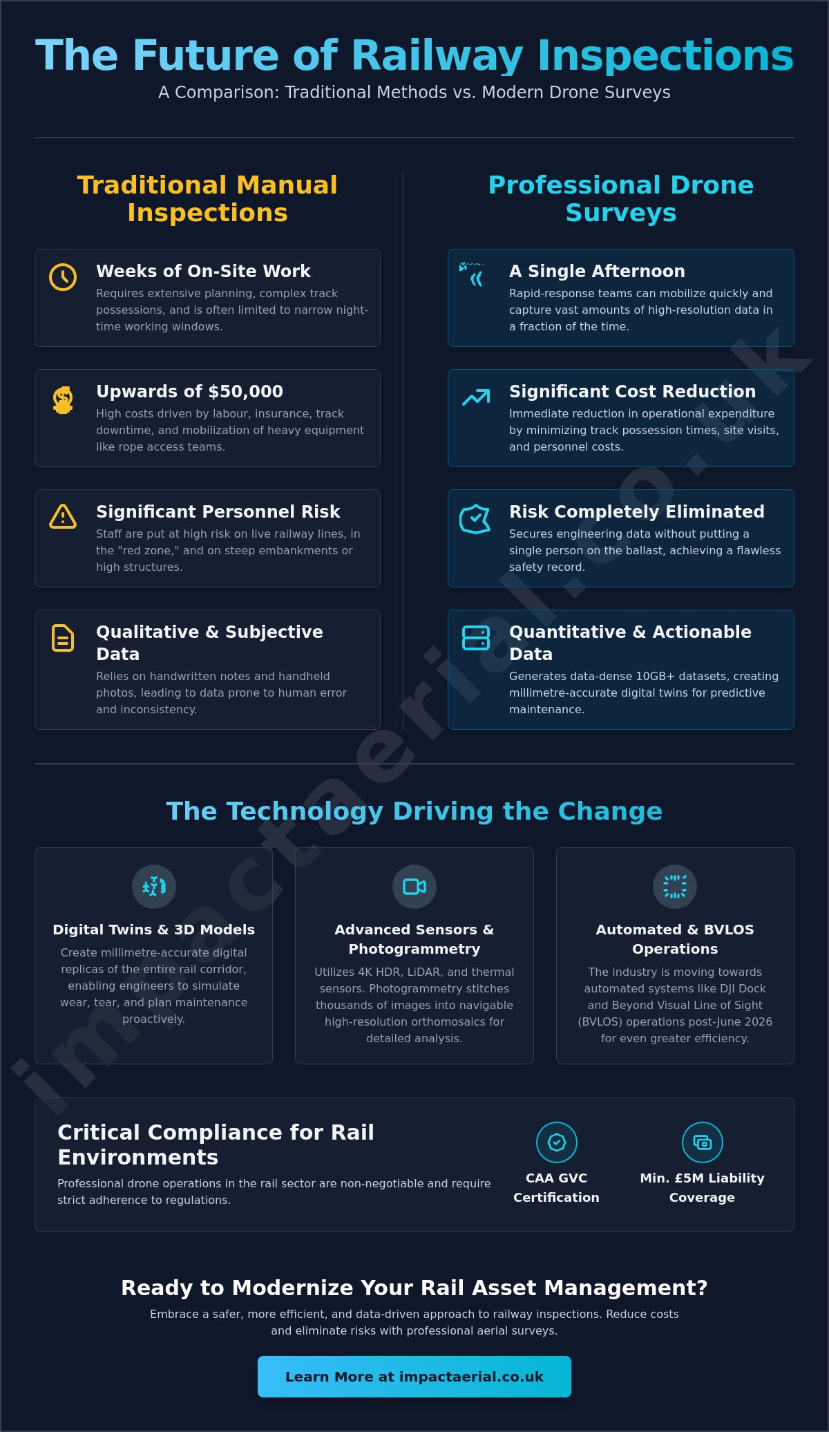
Traditional methods present a constant logistical nightmare. Securing track possessions often requires months of planning and narrow night-time working windows that limit the scope of what can be inspected. Beyond logistics, manual reporting is prone to human error and subjectivity. An engineer’s handwritten notes or handheld photos don’t provide the objective, repeatable digital data that modern systems require. Inspecting steep embankments or high-bridge structures manually carries immense physical risk and often requires expensive rope access teams or heavy plant machinery that’s slow to mobilise.

The ROI of Aerial Rail Monitoring

The financial argument for aerial monitoring is undeniable. By reducing possession times and the frequency of site visits, operators see an immediate reduction in operational expenditure. A drone survey for railway inspections can identify ballast issues or track fatigue months before they lead to a catastrophic failure or an unplanned line closure. The real value lies in long-term data trending. By comparing 2026 survey data with previous datasets, asset managers can perform predictive maintenance with a level of accuracy that was previously impossible. This methodical approach ensures that every pound spent on maintenance is targeted where it’s needed most.

Technical Capabilities: Sensors and Data for Modern Rail Assets

A professional drone survey for railway inspections produces more than just aerial photographs. It generates a comprehensive, multi-layered data suite that serves as the foundation for modern maintenance. By deploying a variety of sensors, from 4K HDR visual cameras to LiDAR and thermal arrays, operators capture high-density datasets that manual walkouts simply cannot replicate. This shift moves the industry away from qualitative “best guesses” toward quantitative, repeatable engineering facts. It’s about turning raw pixels into actionable insights for the permanent way.

High-Resolution Visual Inspection & Photogrammetry

High-fidelity visual data is the cornerstone of structural assessment. Modern sensors capture the minute detail of rail clips, sleepers, and fasteners with millimetre-level precision. This isn’t just about identifying a missing bolt; it’s about using photogrammetry to stitch thousands of images into a single, navigable high-resolution orthomosaic. According to the International Union of Railways, these digital advancements are vital for maximizing line capacity while ensuring absolute safety. These datasets allow for the creation of digital twins. Remote engineering teams can then perform crack propagation analysis or head wear measurements from the safety of the office. This creates a permanent, time-stamped record of the asset’s condition that can be audited at any time.

Thermal and Multi-Spectral Analysis

Thermal imaging adds a critical layer of preventative insight. By identifying thermal anomalies in overhead lines and electrical substations, teams can detect overheating components before they reach critical failure. This level of detail is now a standard component of a professional drone survey workflow. Beyond the tracks, multi-spectral sensors monitor slope stability. They detect subtle changes in soil moisture levels that might indicate drainage issues or potential landslips long before they are visible to the naked eye. This allows for targeted intervention before a minor drainage problem becomes a major operational disruption.

LiDAR and Clearance Monitoring

LiDAR technology completes the technical picture by providing accurate clearance monitoring. It maps vegetation growth against the track with laser precision, ensuring that clearance zones remain compliant with strict safety standards. Unlike manual measurements, LiDAR creates a full 3D point cloud of the rail corridor. This allows engineers to measure distances between the track and surrounding structures with absolute confidence. This data-centric approach ensures that every maintenance action is backed by objective evidence rather than subjective opinion. If you’re looking to transition your asset management to a digital-first model, the specialists at Impact Aerial can help you architect a bespoke data collection strategy.
Drone Survey for Railway Inspections: The Professional Guide to Aerial Rail Asset Management

Comparing Drone Surveys to Traditional Rail Inspection Methods

Comparing a drone survey for railway inspections to traditional manual methods reveals a stark contrast in both efficiency and output quality. Traditional inspections often require heavy plant machinery or specialised rope access teams; both involve significant lead times for mobilisation and complex logistics. In contrast, a drone team can be on-site and operational within minutes of arrival. This speed of deployment is a game-changer for emergency structural assessments following extreme weather events or reported track faults, where time is of the essence.

The difference in data volume is equally significant. A traditional manual walkout typically results in a 10-page PDF report containing subjective observations and a handful of static photographs. Conversely, a single aerial mission generates a 10GB digital dataset. This data is objective, granular, and capable of being re-interrogated by various engineering disciplines long after the flight is complete. Because professional drones follow GPS-guided, repeatable flight paths, the data captured is consistent every time. This allows for precise temporal analysis, where the exact same centimetre of track can be compared month-over-month to monitor degradation.

Reducing Track Access Requirements

One of the most valuable aspects of modern aerial surveys is the ability to operate from outside the rail boundary. Professional teams can often capture all necessary data without ever stepping onto the ballast, which eliminates the need for track access entirely. In specific safety-approved cases, drones can even monitor assets while traffic remains active, providing a unique perspective on how infrastructure behaves under load. This approach removes the reliance on narrow “short possession windows” at night, which often restrict the depth and quality of manual inspections due to time pressure and poor lighting conditions.

Safety Enhancements and Risk Mitigation

Safety remains the primary driver for adopting aerial technology across the UK rail network. By removing personnel from hazardous environments like tunnels, high-span bridges, and steep cuttings, operators significantly lower their risk profile. We often refer to this as the “eyes on the track, feet in the van” approach. It provides a massive psychological benefit for inspection teams, who can focus on data quality from a safe, controlled environment rather than worrying about working at height or near live electrical lines. These professional drone services align directly with Network Rail’s safety-first initiatives, ensuring that every inspection contributes to a better safety record for the entire industry.

Implementing Drone Surveys: Compliance, Safety, and Planning

A professional drone survey for railway inspections is a highly regulated operation that demands more than just technical piloting skills. Success in this sector depends on a meticulous approach to risk mitigation and a deep understanding of the UK’s rigid aviation laws. It isn’t a task for hobbyists or uncertified operators. Every mission must be underpinned by a robust safety management system that accounts for the unique hazards of the rail environment, from high-voltage overhead lines to the complex electromagnetic interference found near traction power stations.

Data security is equally paramount. Railway infrastructure is sensitive national data, and the way this information is stored and processed must meet stringent cybersecurity standards. Professional operators ensure that high-resolution imagery and 3D models are handled through secure, encrypted pipelines. This prevents unauthorised access to critical asset details while ensuring that engineering teams can access the data they need without delay.

Navigating UK CAA Regulations

The regulatory landscape for drone operations has evolved significantly. Securing a drone license through the CAA GVC (General Visual Line of Sight Certificate) pathway is the absolute minimum requirement for commercial rail work. As of 2026, compliance standards require new drones to carry specific UK class markings and Remote ID capabilities. Most rail surveys fall into the ‘Specific’ category, especially when operating near congested areas or sensitive rail hubs. This requires a detailed Operational Authorisation from the Civil Aviation Authority, proving the operator has the necessary safety protocols to manage the increased risk levels of high-consequence environments.

Insurance requirements are also non-negotiable. Standard commercial policies are often insufficient for the rail sector. Professional surveyors carry a minimum of £5 million in public liability insurance specifically tailored for aviation activities in industrial settings. This provides the necessary reassurance to stakeholders that all potential risks are financially indemnified.

The Professional Survey Workflow

A structured workflow is what separates a successful survey from a failed mission. The process is typically divided into three distinct phases:

  • Phase 1: Desktop Study and Authorisation. This involves identifying flight paths, checking airspace restrictions, and notifying local stakeholders or landowners. We conduct a thorough site survey to identify physical hazards before any hardware arrives on-site.
  • Phase 2: On-Site Capture. We utilise DJI Enterprise hardware equipped with high-precision RTK GPS for centimetre-level accuracy. This phase focuses on capturing the exact data points defined during the planning stage, ensuring full coverage of the asset.
  • Phase 3: Post-Production and Reporting. Raw data is processed into actionable engineering reports, 3D point clouds, or orthomosaic maps. This ensures the final delivery provides tangible value to maintenance teams.

If you require a compliant, safety-first partner for your next project, explore how Impact Aerial manages complex rail survey deployments across the UK network.

Partnering with Impact Aerial for National Railway Drone Surveys

Impact Aerial provides a methodical, safety-conscious approach to every drone survey for railway inspections we undertake. Based in Birmingham, our team is strategically positioned to provide rapid response services across the West Midlands and the wider United Kingdom. We understand that rail asset management requires more than just high-quality imagery; it demands a partner who respects the operational complexities and safety protocols of the permanent way. Our commitment to professional excellence ensures that every flight is conducted with the precision required by civil engineering standards.

We exclusively utilise commercial-grade DJI Enterprise hardware to ensure maximum reliability and data accuracy. These systems are designed for industrial environments, featuring redundant systems and high-precision GPS that consumer drones simply cannot match. Once the data is captured, our post-production services transform raw aerial footage into detailed technical surveys. This expert processing allows your engineering teams to identify minute structural anomalies or vegetation encroachments with absolute confidence, providing a clear path for proactive maintenance planning.

Expert Pilots and Meticulous Safety Standards

Our reputation is built on a foundation of compliance and risk mitigation. All Impact Aerial pilots are CAA GVC certified and possess extensive experience in complex commercial surveying. We don’t just follow regulations; we integrate them into every stage of our workflow. To provide total peace of mind for our rail clients, we maintain £5 million in commercial liability insurance specifically tailored for high-consequence environments. Our goal is to act as a trusted technical consultant, offering the reassurance that your project is in safe, expert hands from initial desktop study to final data delivery.

Scalable Solutions for UK Rail Infrastructure

The requirements of the rail network are diverse, and our services are designed to be fully scalable. We handle everything from the detailed inspection of a single bridge structure to multi-mile track corridor mapping projects. By integrating our high-end aerial filming capabilities with technical survey drone technology, we provide a comprehensive documentation package that serves both engineering and stakeholder communication needs. This dual approach ensures that you have both the technical data for maintenance and the visual assets for project reporting. Contact Impact Aerial today to discuss your specific railway inspection requirements and discover how our meticulous approach can improve your asset management strategy.

Advancing Rail Safety Through Digital Innovation

The adoption of aerial technology is no longer a luxury for rail operators; it’s a fundamental requirement for maintaining a modern, safe, and efficient network. By transitioning from manual walkouts to a data-driven approach, you secure millimetre-accurate insights while eliminating the need for hazardous track possessions. This shift enables your engineering teams to move from reactive repairs to predictive asset management using high-fidelity digital twins that capture every detail of the permanent way.

Commissioning a professional drone survey for railway inspections ensures your project meets the highest UK safety and regulatory standards. Impact Aerial provides the technical expertise and operational reassurance needed for high-consequence environments. Our services are underpinned by CAA GVC certified pilots, £5m commercial liability insurance, and the latest DJI Enterprise commercial hardware. This meticulous approach guarantees that your data is both legally compliant and technically superior.

Take the next step in modernising your asset management strategy. Request a Professional Rail Survey Quote from Impact Aerial today and discover how aerial precision can transform your maintenance outcomes. We look forward to supporting your infrastructure goals with unparalleled technical reliability.

Frequently Asked Questions

Are drones allowed to fly over live railway lines in the UK?

Yes, drones are permitted to fly over live railway lines provided the operator holds a valid Operational Authorisation from the Civil Aviation Authority (CAA). For a drone survey for railway inspections, pilots must operate within the ‘Specific’ category and adhere to strict safety cases. Recent June 2026 policy changes have further streamlined Beyond Visual Line of Sight (BVLOS) flights for infrastructure, allowing for more efficient remote monitoring without disrupting active train services.

How accurate is drone data for railway track inspections?

Modern aerial data collection provides millimetre-level accuracy, often surpassing the precision of manual measurements. By using DJI Enterprise hardware equipped with Real-Time Kinematic (RTK) GPS, we ensure that every pixel and 3D point cloud coordinate is correctly georeferenced. This level of detail allows engineers to detect minute structural shifts, track fatigue, or ballast degradation that might be missed during a traditional manual walkout.

Do drone surveys require track possessions or closures?

Most aerial inspections don’t require track possessions or line closures, which is a significant operational advantage for network managers. We typically operate from outside the rail boundary, capturing high-resolution data while trains continue to run. This eliminates the logistical complexity of scheduling night-time working windows and ensures that asset management doesn’t interfere with passenger or freight timetables.

What are the safety benefits of using drones for rail inspections?

The primary benefit is the total elimination of “red zone” working for inspection personnel. By using drones, staff remain in a safe, controlled environment away from live tracks, high-voltage overhead lines, and steep embankments. This approach significantly reduces the risk of on-site accidents and helps maintain a flawless safety record for maintenance teams while providing superior data quality for structural analysis.

What kind of sensors are used for railway drone surveys?

We utilise a sophisticated array of sensors tailored to the specific asset being inspected. High-resolution 4K HDR cameras capture visual detail of sleepers and fasteners, while LiDAR sensors generate precise 3D point clouds for clearance monitoring. Additionally, thermal sensors detect overheating electrical components, and multi-spectral sensors can identify soil moisture issues that might compromise embankment stability before a failure occurs.

How much does a drone railway survey cost compared to traditional methods?

While specific project costs vary, the overall expenditure for a drone survey for railway inspections is significantly lower than traditional methods. Traditional bridge inspections often involve massive costs for scaffolding, rope access teams, and plant machinery. Aerial surveys remove these requirements, offering a substantial return on investment through reduced site hours, fewer personnel, and the prevention of expensive emergency repairs through earlier fault detection.

What qualifications do drone pilots need for rail work?

For commercial rail work, pilots must hold a CAA GVC (General Visual Line of Sight Certificate) and be registered with both Flyer and Operator IDs. As of 2026, they must also ensure their hardware meets current class markings and Remote ID standards. Beyond these legal requirements, professional rail pilots should have specific training in risk mitigation and be covered by high-level commercial liability insurance.

How long does it take to process the data from a rail survey?

Processing times depend on the complexity of the dataset, but initial actionable reports are typically delivered within 48 to 72 hours. Large-scale corridor mapping involving 10GB or more of raw data requires intensive post-production to stitch orthomosaics or generate 3D digital twins. This timeline is still considerably faster than the weeks often required to compile, verify, and distribute complex manual engineering reports.
Drone Survey for Pipeline Monitoring: The Professional UK Guide 2026

Did you know that drone-based inspections can reduce costs by up to 70% compared to traditional helicopter patrols while delivering faster, more accurate defect detection? For UK asset managers, the challenge of monitoring thousands of miles of infrastructure across hazardous or remote terrain has always been a high-stakes balance of safety and expenditure. You’re likely all too familiar with the slow reporting cycles and the inherent risks of sending ground teams into difficult environments.

Utilizing a professional drone survey for pipeline monitoring is no longer a futuristic concept; it’s a regulatory and operational necessity for maintaining asset integrity in 2026. This guide reveals how commercial drone technology transforms pipeline oversight, providing CAA-compliant monitoring that drastically reduces your risk profile. We’ll explore the latest UK drone classifications, the shift toward Beyond Visual Line of Sight (BVLOS) operations, and how high-resolution digital twins are replacing outdated data silos with actionable, high-tier intelligence.

Key Takeaways

  • Learn how transitioning from manual ground patrols to aerial data collection can reduce operational expenditure by up to 70% while significantly improving site safety.
  • Understand the technical role of 4K HDR cameras and specialized sensors in identifying structural anomalies and third-party encroachments with high-tier precision.
  • Identify the mandatory UK regulatory standards for a drone survey for pipeline monitoring, including CAA GVC certifications and the necessity of £5m commercial liability insurance.
  • Discover how high-resolution digital twins and accelerated reporting cycles enable faster leak detection and more proactive asset management across your entire network.
  • Explore how commercial-grade DJI Enterprise hardware overcomes the logistical challenges of monitoring critical infrastructure in remote or hazardous UK terrain.

The Evolution of Pipeline Monitoring: Why UAVs are the New Standard

The shift toward unmanned aerial vehicles (UAVs) in the UK utility sector isn’t just about following a trend; it’s a response to the inherent failures of legacy inspection models. For decades, pipeline integrity relied on manual ground patrols, where teams navigated miles of difficult terrain to spot leaks or encroachments. This approach is notoriously slow. It exposes workers to significant safety risks. By integrating a drone survey for pipeline monitoring, operators can now oversee vast networks with a level of precision that was previously impossible.

To better understand this concept, watch this helpful video demonstrating utility inspection workflows:

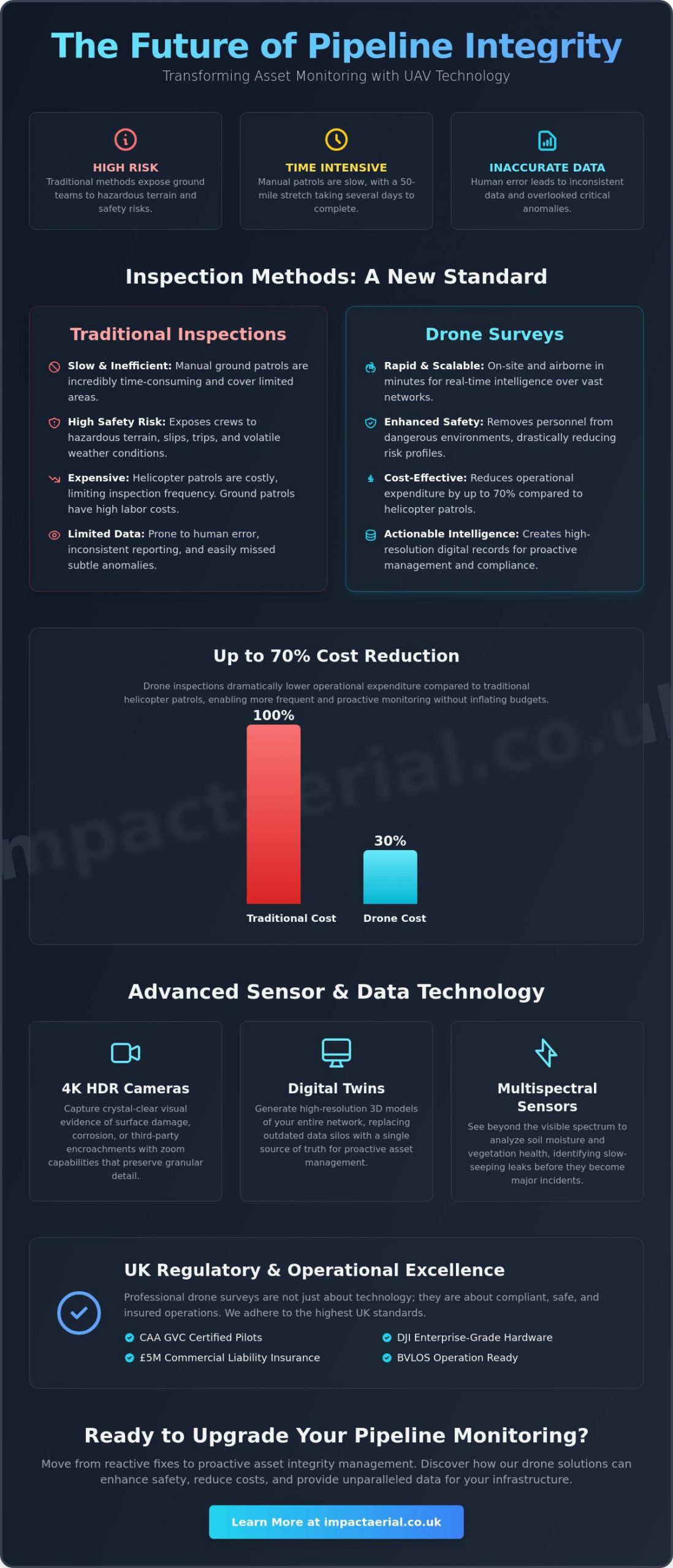
Modern UAVs utilize advanced remote sensing technology to capture data that the human eye might miss. This transition from reactive “break-fix” cycles to proactive asset integrity management is essential for environmental protection. Research from 2026 indicates that drone-based inspections can reduce costs by 50-70% compared to helicopter patrols. This allows for more frequent checks and earlier leak prevention without inflating operational budgets. The result is a safer, more reliable infrastructure that meets the increasing demands of UK regulators.

Challenges of Traditional Pipeline Inspections

Manual inspections in the UK often involve trekking through remote marshes or across steep, hazardous slopes. These environments pose constant slip and trip hazards for ground crews, especially in volatile weather. Beyond the physical danger, walking a 50-mile pipeline stretch is incredibly time-intensive. It often takes several days to complete a single circuit. Human error also plays a major role in these legacy methods. Manual data recording is frequently inconsistent, and subtle anomalies like slight ground subsidence or early-stage corrosion are easily overlooked during long, fatiguing shifts.

The Strategic Advantage of Aerial Oversight

Aerial platforms offer rapid deployment capabilities that traditional methods can’t match. In the event of a suspected pressure drop or environmental incident, a drone can be on-site and airborne in minutes to provide real-time situational intelligence. This high-frequency monitoring doesn’t require an increase in headcount, making it a scalable solution for growing networks. Perhaps most importantly, every drone survey for pipeline monitoring creates a comprehensive, high-resolution digital record. This permanent data trail is invaluable for regulatory auditing, ensuring that your compliance with UK safety standards is documented with absolute clarity and precision.

Technical Capabilities: Sensor Technology and Data Precision

A professional drone survey for pipeline monitoring relies on a sophisticated payload of specialized sensors designed to identify structural and environmental anomalies with surgical precision. While standard photography has its place, professional utility inspections require high-tier hardware that sees beyond the visible spectrum. We utilize 4K HDR cameras to provide crystal-clear visual evidence of third-party encroachment or surface damage. These high-resolution outputs allow engineers to zoom in on specific assets without losing the granular detail required for informed decision-making. Using such advanced technology ensures that every flight delivers actionable intelligence rather than just raw imagery.

Effective monitoring also requires understanding the ground conditions surrounding the asset. Multispectral sensors analyze soil moisture levels and vegetation health, which often indicate slow-seeping leaks that haven’t yet reached the surface. Because all operations must strictly adhere to UK drone regulations, using calibrated, enterprise-grade equipment ensures that the data collected is both legally compliant and technically sound. This meticulous approach to hardware selection is what separates a basic aerial view from a comprehensive industrial inspection.

Thermal Imaging for Leak Detection

Thermal sensors are indispensable for identifying fluid leaks by detecting subtle temperature variations in the surrounding soil. When a pressurized pipe fails, the escaping substance often changes the thermal signature of the ground above it. In the UK’s temperate climate, these surveys are most effective during periods of high thermal contrast, such as early morning. By integrating thermal data with visual overlays, we create a composite view that makes it easy for maintenance teams to pinpoint the exact location of a subsurface issue. This level of detail is a core component of our professional drone survey services, helping clients mitigate environmental risks before they escalate.

LiDAR and 3D Mapping for Structural Integrity

LiDAR (Light Detection and Ranging) technology is a game-changer for monitoring pipelines in heavily wooded or overgrown areas. Unlike standard photogrammetry, LiDAR pulses can penetrate dense vegetation to map the actual ground surface. This allows us to generate engineering-grade 3D digital twins of pipeline corridors. These models are essential for monitoring long-term subsidence or ground movement that could compromise structural integrity. Achieving the accuracy levels required for these surveys demands meticulous flight planning and high-end processing, resulting in a comprehensive digital asset that serves as a baseline for all future inspections.

Drone Survey for Pipeline Monitoring: The Professional UK Guide 2026

The Business Case: Comparing Drone Surveys to Traditional Methods

The financial justification for upgrading legacy inspection protocols is clear. While manual ground patrols and manned helicopter flights were once the industry standard, they carry significant overheads and logistical burdens. Research indicates that a drone survey for pipeline monitoring can be 30-70% cheaper than traditional methods involving rope access, scaffolding, or aircraft. These savings aren’t just found in the direct cost of the survey itself but also in the reduction of support staff and heavy equipment required to facilitate inspections in remote areas.

Asset managers must also consider the broader implications of pipeline infrastructure economics when planning their maintenance budgets. Traditional methods often result in data silos and slow reporting cycles, where anomalies might not be flagged until weeks after the initial site visit. In contrast, aerial surveys accelerate the reporting cycle by providing near-instant access to high-resolution data. This rapid time-to-data allows for quicker decision-making, potentially preventing minor issues from escalating into costly environmental disasters or operational shutdowns.

The environmental impact of these operations is another critical factor. Moving away from fuel-heavy helicopters toward electric-powered UAVs significantly lowers the carbon footprint of your inspection program. This shift supports corporate sustainability goals while maintaining a rigorous oversight schedule that meets the mandated inspection frequencies required by UK authorities.

Operational Efficiency and Speed

Efficiency is built into the workflow of modern aerial surveys. A single flight team can cover dozens of kilometres of pipeline in a single day, a task that would take a ground crew several weeks to complete. We utilize automated flight paths to ensure that data collection is repeatable and consistent across every inspection cycle. This consistency is vital for change detection, allowing engineers to overlay historical data with current imagery to spot subtle shifts in the landscape. Once the flight is complete, our rapid post-production services deliver processed data through secure cloud platforms, ensuring that your team has the information they need without delay.

Risk Mitigation and Safety Standards

Safety remains the primary driver for drone adoption in the industrial sector. By deploying UAVs, you remove personnel from high-risk environments, such as steep embankments, marshlands, or areas with restricted access. Drones also provide an early warning system for third-party encroachments, such as unauthorized construction or vegetation overgrowth that could threaten the asset. In the context of UAV pipeline surveys, risk mitigation is the systematic reduction of physical danger to personnel and the proactive identification of external threats to asset integrity. Implementing a professional drone survey for pipeline monitoring ensures that your safety ROI is maximized by reducing “man-hours at risk” while simultaneously improving the quality of your oversight.

Operational Excellence: Compliance, Safety, and UK Regulations

Operating a drone survey for pipeline monitoring in the UK requires more than just high-end hardware; it demands a rigorous commitment to national aviation laws and industrial safety standards. Compliance is the foundation of every flight we undertake. It ensures that data collection is not only accurate but also legally defensible and safe for all stakeholders involved. For asset managers, partnering with a provider that understands the nuances of the 2026 regulatory landscape is essential for mitigating long-term liability. We approach every mission with a meticulous mindset, prioritizing risk management and official certification above all else.

CAA Regulations and Pilot Certification

The Civil Aviation Authority (CAA) maintains strict oversight of commercial drone operations, particularly those involving critical national infrastructure. It is vital that your chosen provider is CAA GVC certified to operate in the ‘Specific’ category. This qualification allows for more complex maneuvers that fall outside standard recreational limits. As of January 1, 2026, all new drones used for industrial work must also feature UK-specific class marks and mandatory Remote ID technology. For long-distance pipeline oversight, we often operate under specific authorizations for Beyond Visual Line of Sight (BVLOS) flights. This capability is essential for covering vast distances efficiently while maintaining a robust Safety Management System (SMS) and detailed flight logs for every mission.

Insurance is another non-negotiable factor in professional utility work. While basic commercial policies exist, industrial sites typically require a minimum of £5m commercial liability insurance. This coverage provides the necessary reassurance for stakeholders when operating near high-value assets. We also ensure that all data collection adheres to strict GDPR and data protection protocols, safeguarding the privacy of landowners and the security of sensitive infrastructure imagery.

Site Safety and Risk Assessment

Every drone survey for pipeline monitoring begins with exhaustive pre-flight planning. This includes checking for NOTAMs (Notices to Airmen) to identify temporary airspace restrictions and securing all necessary landowner permissions along the route. On-site, we establish clear launch zones and utilize trained spotters to maintain situational awareness. Our hardware choice reflects this focus on reliability. We utilize commercial-grade DJI Enterprise drones equipped with dual-battery systems and redundant flight controllers. These systems ensure that even in the unlikely event of a component failure, the aircraft can return to home safely. If you require an inspection partner that prioritizes these high-tier safety standards, view our professional drone survey services to see how we can support your next project.

Risk assessments for critical infrastructure are particularly detailed. We analyze potential electromagnetic interference and local terrain challenges before the rotors even turn. This methodical approach ensures that we identify and mitigate hazards such as third-party encroachments or hazardous weather patterns early in the planning phase. By combining technical expertise with a safety-first culture, we deliver high-resolution data without compromising the integrity of your site or the safety of the public.

Implementing Drone Monitoring with Impact Aerial

Impact Aerial provides specialized drone survey for pipeline monitoring services designed to address the unique geographical and regulatory challenges of the UK. From our strategic operations base in Birmingham and the West Midlands, we provide nationwide coverage to support critical infrastructure networks. Our approach is built on a foundation of technical precision and meticulous safety protocols, ensuring that every mission delivers high-tier data while remaining fully compliant with national aviation laws. We don’t just capture imagery; we provide a comprehensive oversight solution that integrates seamlessly into your existing asset management workflows.

Our team understands that pipeline integrity is a high-stakes environment where data accuracy is non-negotiable. We utilize commercial-grade DJI Enterprise drones, which offer the redundancy and sensor stability required for industrial surveying. By combining this high-end hardware with a methodical operational style, we ensure that your drone survey for pipeline monitoring delivers a level of detail that manual ground patrols simply cannot match. This commitment to quality and precision is why we are a trusted partner for utility operators across the country.

Our Professional Survey Workflow

Every project begins with an in-depth consultation to define your specific asset monitoring requirements. Whether you need to detect third-party encroachments or perform detailed structural analysis, we tailor our flight parameters to meet those engineering goals. During the precision data capture phase, we utilize 4K HDR visual cameras and thermal sensors to identify anomalies with surgical accuracy. Once the flight is complete, our full-service model extends into expert post-production. We process the raw data to generate detailed reports and 3D mapping for your engineering teams, providing a clear digital record of asset health. This end-to-end drone survey workflow ensures you receive actionable intelligence without the burden of internal data processing.

Why Choose Impact Aerial for Pipeline Oversight?

We distinguish ourselves through a deep commitment to regulatory excellence and technical expertise. Our pilots possess extensive backgrounds in technical surveying, ensuring they understand the industrial context of the data they collect. We maintain a strict adherence to all CAA safety standards and drone services regulations, providing the reassurance and reliability that critical infrastructure projects demand. By choosing a partner that values external validation and high-tier quality, you ensure that your monitoring program is legally compliant and operationally sound. We focus on providing the psychological comfort of knowing your assets are in expert hands, backed by comprehensive insurance and professional certifications.

Contact Impact Aerial today for a professional pipeline survey quote and discover how our aerial data solutions can transform your asset integrity management.

Advancing Your Pipeline Integrity Strategy

Adopting a proactive approach to infrastructure oversight is essential for navigating the complex operational and environmental demands of 2026. A professional drone survey for pipeline monitoring delivers more than just high-resolution imagery; it provides a scalable, data-driven framework for identifying leaks and third-party encroachments before they escalate. By replacing slow, hazardous ground patrols with precision aerial surveys, you can achieve a significant reduction in operational expenditure while improving the quality of your asset integrity records.

Our team at Impact Aerial is committed to delivering these high-tier results through a combination of technical expertise and strict regulatory compliance. We operate a specialized DJI Enterprise Hardware Fleet and employ only CAA GVC Certified Pilots to ensure every mission meets the highest safety benchmarks. With £5m Commercial Liability Insurance as a standard, we offer the reliability and reassurance required for critical national infrastructure projects across the UK. We’re ready to help you elevate your monitoring standards and protect your long-term asset value.

Request a Professional Pipeline Survey Quote from Impact Aerial and take the first step toward a more resilient and efficient network today.

Frequently Asked Questions

Is a drone survey for pipeline monitoring legal in the UK?

Yes, conducting a drone survey for pipeline monitoring is entirely legal in the UK when performed by a CAA-certified operator. Professional pilots must adhere to the 2026 UK drone classifications and hold either an A2 CofC or a GVC certification depending on the weight of the aircraft and the complexity of the flight path. For industrial surveys near critical infrastructure, we operate under specific authorizations that ensure every mission meets the highest safety and legal standards.

Can drones detect gas leaks in underground pipelines?

Drones detect gas leaks by utilizing specialized optical gas imaging (OGI) sensors or laser-based methane detectors. These payloads identify gas plumes that are completely invisible to the human eye or standard cameras. Additionally, thermal sensors can identify subsurface leaks by spotting subtle temperature changes in the soil caused by escaping pressurized fluids. This multi-sensor approach allows for the early detection of leaks before they cause significant environmental damage.

How much does a commercial drone pipeline survey cost?

The cost of a commercial drone survey depends on several variables, including the total distance of the pipeline, the type of sensors required, and the complexity of the terrain. While we don’t provide fixed pricing due to the bespoke nature of utility work, drone-based methods are consistently more cost-effective than traditional alternatives. Utilizing UAVs typically reduces the need for expensive manned helicopter flights or large ground teams, lowering your overall operational expenditure.

What happens if the weather is bad on the day of the survey?

We reschedule flight operations if the weather conditions exceed the safe operating limits of our DJI Enterprise hardware or if the data quality would be compromised. High winds, heavy rain, or thick fog can interfere with both flight stability and sensor accuracy. Our team monitors specialized aviation forecasts closely in the days leading up to a mission. We coordinate with your project managers to ensure the survey takes place during an optimal weather window.

How accurate is the data collected by a pipeline drone?

Data collected by professional drones is exceptionally accurate, often achieving centimetre-level precision when using RTK (Real-Time Kinematic) positioning. When combined with LiDAR sensors, we can generate engineering-grade 3D digital twins that allow for meticulous subsidence monitoring and structural analysis. This level of granularity is significantly higher than what is typically achievable through satellite imagery or manned aircraft inspections, providing a more reliable baseline for asset integrity management.

Do you need permission from landowners to fly over pipelines?

Yes, we require permission from landowners for the take-off and landing of the aircraft on private property. While the CAA regulates the airspace, the practicalities of a drone survey for pipeline monitoring often involve accessing specific land parcels to maintain a safe launch zone. As part of our comprehensive pre-flight planning, we handle the coordination of these permissions to ensure that all operations are conducted with the full consent of local stakeholders.

What is the difference between a visual and a thermal pipeline inspection?

Visual inspections use 4K HDR cameras to identify surface-level issues like third-party encroachment, vegetation overgrowth, or visible structural damage. In contrast, thermal inspections utilize infrared sensors to detect heat signatures and temperature variations. While visual data is excellent for general oversight, thermal imaging is essential for identifying subsurface leaks or insulation failures that aren’t visible to the naked eye. Combining both provides a complete picture of asset health.

Can drones monitor pipelines in urban areas like Birmingham?

Drones can monitor pipelines in urban environments like Birmingham, but these missions require more stringent risk assessments and specific CAA authorizations. Operating in congested areas involves managing complex safety factors and potential signal interference. We utilize redundant flight systems and meticulous site-specific safety protocols to ensure these urban surveys are completed without risk to the public. This allows for efficient oversight of critical infrastructure even in densely populated regions.

Drone Survey for Environmental Impact Assessment: The 2026 Professional Guide

Why spend weeks on a manual topographic survey when a professional drone survey for environmental impact assessment can capture high-precision data for a 20-acre site in a single day? You’re likely familiar with the high costs and safety risks associated with traditional ground-based ecological surveys, especially when dealing with inaccessible or hazardous terrain. It’s often difficult to provide the visual evidence required for stakeholder engagement when you’re relying on limited ground-level perspectives.

This 2026 guide will show you how to streamline your Environmental Impact Assessments (EIA) by providing project-ready data for planning submissions while ensuring full CAA compliance. You’ll learn how to reduce survey time and improve site safety through advanced aerial capture. We’ll also examine the latest industry shifts, including the transition toward beyond-visual-line-of-sight (BVLOS) operations and the increasing importance of NDAA-compliant hardware for sensitive projects.

Key Takeaways

  • Understand the technical distinctions between LiDAR and photogrammetry to ensure your data meets the specific precision requirements of your ecological baseline.
  • Discover how a drone survey for environmental impact assessment can reduce operational costs by up to 75% while significantly improving site safety in hazardous environments.
  • Learn to integrate high-resolution aerial data into your planning workflow by aligning flight schedules with critical ecological survey windows.
  • Identify why professional credentials, including CAA GVC certification and £5m liability insurance, are non-negotiable for mitigating risk in commercial projects.

The Role of Drone Technology in Modern Environmental Impact Assessments

Traditional methods for conducting an Environmental Impact Assessment (EIA) often rely on multi-person teams traversing complex sites on foot. This approach faces significant hurdles when sites feature hazardous terrain, dense vegetation, or vast acreage that makes ground-level observation difficult. A professional drone survey for environmental impact assessment provides a more efficient alternative, capturing comprehensive site data while maintaining a safe distance from potential hazards. This shift toward digital-first assessments is gaining momentum within the UK planning system as authorities demand more precise, transparent, and easily shareable data.

To better understand the practical application of this technology, watch this helpful video:

Beyond the obvious speed advantages, aerial technology offers a strictly non-invasive methodology. Traditional surveys can inadvertently disturb sensitive flora and fauna through heavy foot traffic or equipment transport. Drones operate from a safe altitude, allowing for meticulous data collection without physical contact with the environment. High-resolution aerial perspectives also help project managers identify ecological constraints, such as hidden watercourses or specific habitat types, early in the planning phase. This early detection prevents costly delays and allows for better-informed site design from the outset.

Meeting 2026 Environmental Standards

By 2026, the requirements for Biodiversity Net Gain (BNG) documentation have become more complex, making a drone survey for environmental impact assessment the preferred method for establishing a reliable baseline. Professional surveys provide a defensible, high-accuracy dataset that is essential for long-term environmental monitoring. Using time-stamped and geo-referenced evidence ensures that every data point is verifiable and repeatable for future comparisons. This level of detail is vital for regulatory audits and provides planning authorities with the confidence that environmental mitigation claims are backed by rigorous, scientific precision.

Scalability Across Diverse UK Landscapes

The versatility of drone hardware allows it to adapt to various environments across the UK. Whether you are assessing compact urban brownfield sites or expansive peatlands in the West Midlands, the technology remains consistent. Professionals can now capture data across dozens of hectares in just a few hours, a task that would take weeks of traditional foot-surveys. The resulting high-end visual output helps stakeholders, including local communities and planning boards, visualize the site context and the proposed project impact with absolute clarity.

Advanced Data Capture: From LiDAR to Multispectral Imaging

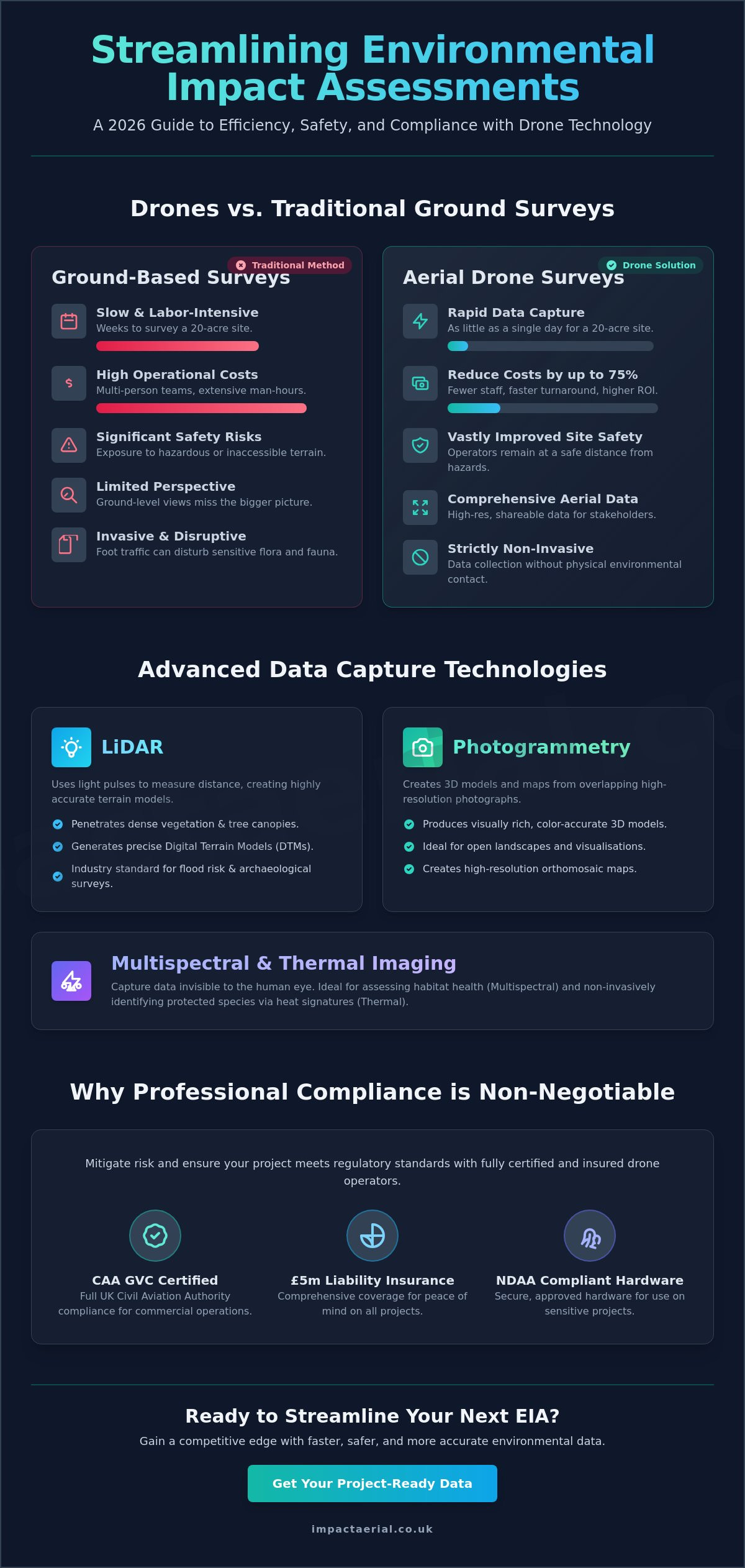
The efficacy of a drone survey for environmental impact assessment hinges on selecting the correct sensor for the target environment. LiDAR is a remote sensing method that uses light pulses to measure ranges to the Earth. While photogrammetry is excellent for creating visually rich, color-accurate models of open landscapes, LiDAR remains the industry standard for penetrating dense woodland canopies to generate accurate Digital Terrain Models (DTMs). This technical distinction is critical for flood risk assessments and archaeological site evaluations where the ground surface is often obscured by thick vegetation.

Beyond terrain mapping, multispectral imaging offers a scientific approach to assessing habitat health. By capturing data across specific light bands, including Near-Infrared and Red Edge, sensors can detect early signs of plant stress or disease that are invisible to the naked eye. This capability is invaluable for habitat classification and monitoring Biodiversity Net Gain (BNG) metrics over time. Thermal imaging further extends these capabilities. It allows for the non-invasive identification of protected species, such as bats or nesting birds, by detecting their heat signatures against cooler backgrounds. It’s also a vital tool for identifying thermal discharge or heat signatures in water bodies near industrial sites.

High-Resolution Mapping and Orthomosaics

Creating project-ready, scale-accurate 2D maps requires the use of 4K HDR cameras and precision flight planning. The resulting orthomosaics provide a comprehensive view of the entire survey area with sub-centimetre resolution. Because this imagery is geo-referenced, it integrates directly into Geographic Information Systems (GIS), allowing ecological consultants to layer their findings on top of a highly detailed, current base map. This level of detail ensures that every feature, from individual trees to subtle changes in ground cover, is documented for regulatory audits.

3D Modelling for Visual Impact Analysis

Generating digital twins provides a powerful tool for visualising how a proposed development will sit within the natural landscape. These 3D models are built from dense point clouds, which allow for precise volumetric measurements of earthworks, stockpiles, or coastal erosion. Using 3D data in public consultations helps demystify complex projects for stakeholders and local planning authorities. To ensure your raw data is converted into high-tier evidence, professional post-production services are often required to clean and refine these complex models for final EIA reporting.

Drone Survey for Environmental Impact Assessment: The 2026 Professional Guide

Drones vs. Traditional Ground Surveys: Efficiency, Safety, and Accuracy

Comparing a professional drone survey for environmental impact assessment to traditional ground-based methods reveals a significant gap in both operational efficiency and data depth. Manual surveys often require multi-person teams to spend weeks on-site, manually recording data points with total stations or handheld GPS units. This process is inherently slow and exposes staff to hazardous environments such as steep cliffs, tidal marshes, or unstable structures. Drones eliminate these risks by capturing the same data from the air, keeping personnel safely on stable ground while covering the same area in a fraction of the time.

Industry data suggests that drone surveys can be 50% to 75% less expensive than traditional ground-based surveys for the same project area. For example, a traditional topographic survey of a 20-acre site typically takes one to two weeks to complete. A drone can capture that same 20-acre site in a single day. This speed doesn’t just save money; it allows project managers to meet tight planning deadlines that would be impossible with manual methods. Automated flight paths also remove the risk of human error in manual mapping, ensuring that every centimetre of the site is documented with high-precision GPS positioning.

Repeatability is another critical advantage for long-term projects. Because drones use pre-programmed flight paths, they can return to the exact same coordinates months or years later. This ensures perfect data consistency for seasonal monitoring, allowing environmental consultants to track habitat changes or vegetation growth with absolute confidence. This level of temporal accuracy is nearly impossible to replicate with manual ground teams over multiple site visits.

Safety and Risk Mitigation on Site

Drones provide a safer alternative by removing the need for surveyors to work at height or enter deep, fast-moving water. This reduction in physical risk is a cornerstone of professional operations. A reputable operator will always carry £5m commercial liability insurance, which is the industry standard for high-stakes environmental projects. Beyond human safety, aerial surveys protect the environment itself. By removing foot traffic from sensitive areas, drones mitigate the risk of habitat trampling or the accidental spread of invasive species during the data collection process.

Data Accuracy and RTK Precision

Modern surveying drones often utilize Real-Time Kinematic (RTK) technology to achieve centimetre-level accuracy without the need for extensive ground control points. This precision is vital when defending EIA findings in court or during rigorous planning inquiries. While a traditional surveyor might collect hundreds of individual points, a LiDAR drone survey captures millions of points per flight. This incredible data density provides a much more detailed and reliable representation of the terrain, ensuring that no ecological constraint is overlooked.

Integrating Drone Data into Your Planning and Compliance Workflow

Successful integration of a drone survey for environmental impact assessment begins long before the aircraft leaves the ground. A pre-survey consultation is essential to align flight paths with specific ecological survey windows, ensuring data collection doesn’t interfere with protected species’ breeding seasons. This meticulous planning ensures that the resulting data satisfies the rigorous requirements of local planning authorities. In the UK, the synergy between CAA GVC certification and planning authority expectations is critical. Planners require data that is not only accurate but collected by an operator who understands the strict legal framework of commercial airspace.

The transition from raw data capture to a final EIA report involves a structured technical workflow. After the flight, raw imagery and sensor data undergo intensive processing to ensure they’re compatible with the software used by architects and planning officers, such as AutoCAD or ArcGIS. Collaborating with ecologists at this stage is vital. They use the high-resolution and multispectral imagery to classify habitats and identify ecological constraints with a level of detail that ground surveys can’t match. To ensure your datasets are refined for maximum impact, professional post-production services transform raw captures into project-ready evidence.

Seasonal Monitoring and Change Detection

Maintaining environmental compliance requires more than a single snapshot. Scheduling repeat surveys allows for automated change detection, which is essential for monitoring the spread of invasive species or tracking coastal erosion over time. Using ‘before and after’ overlays provides visual proof that environmental mitigation strategies are being followed during the construction phase. This temporal data is increasingly required to satisfy Biodiversity Net Gain (BNG) monitoring obligations, which often span several years.

Legal and Regulatory Evidence

Drone data creates a permanent, unalterable audit trail for every stage of a project. When presenting evidence to the Planning Inspectorate during appeals or inquiries, high-resolution aerial imagery provides a level of clarity that traditional reports lack. It’s a powerful tool for defending environmental strategies against public or regulatory scrutiny. Throughout this process, all data collection must strictly adhere to UK GDPR and privacy regulations. Professional operators ensure that any identifiable personal data is handled or redacted according to current legal standards, protecting both the client and the public.

Professional EIA Drone Services: Why Compliance and Certification Matter

Hiring a professional for a drone survey for environmental impact assessment is about more than just capturing high-resolution images. It’s a matter of regulatory compliance and rigorous risk management. In the UK, commercial drone operations are strictly governed by the Civil Aviation Authority (CAA). For complex EIA projects, hiring pilots who hold a General Visual Line of Sight Certificate (GVC) is essential. This certification proves the operator has passed rigorous theoretical and practical assessments, ensuring they can safely manage commercial flights in the challenging environments often found on development sites.

Safety is the primary concern for any project manager or ecological consultant. This is why £5m commercial liability insurance is the industry standard for professional drone surveys. It provides the necessary reassurance that all parties are protected against unforeseen events during the data collection process. Beyond the legalities, the choice of hardware directly impacts the quality of the final EIA report. We utilize high-end commercial platforms specifically engineered for the precision required in surveying. These systems provide the flight stability and sensor accuracy needed to deliver reliable data that planning officers and stakeholders can trust.

Regional knowledge is equally important for a successful survey. Having local expertise in Birmingham and the West Midlands allows an operator to navigate the specific geographical and regulatory nuances of the area. Local planning authorities often have specific expectations for data presentation. A partner who understands these regional requirements can significantly streamline the planning submission process and reduce the likelihood of data rejection.

The Impact Aerial Standard

Our approach centers on delivering high-tier quality through the use of commercial-grade drones equipped with 4K HDR cameras. This hardware ensures maximum clarity for habitat identification and detailed terrain mapping. Every project begins with a meticulous risk assessment and a commitment to safety-first operations that protect both people and sensitive environments. You can explore our broader drone survey capabilities to see how we apply these professional standards across various industrial sectors.

Choosing a Verified Partner

Vetting a drone provider requires looking beyond a simple portfolio of aerial photos. Professional affiliations and industry registers act as a non-verbal signature of quality and operational reliability. It’s important to understand the current UK drone license requirements for 2026 to ensure your chosen partner is fully compliant with the latest CAA rules. This due diligence protects your project from legal complications and ensures the data is admissible in formal planning inquiries.

If you’re ready to improve your site safety and data accuracy, contact us to request a tailored quote for your next environmental impact assessment project. We provide detailed consultations to ensure our flight paths and sensor choices align perfectly with your ecological requirements and planning deadlines.

Securing Your Project’s Future with Aerial Precision

Transitioning to a digital-first approach is no longer optional for complex planning submissions. By choosing a professional drone survey for environmental impact assessment, you gain access to centimetre-level data that traditional ground teams simply cannot match in the same timeframe. These surveys mitigate site risks while providing the high-resolution evidence required for Biodiversity Net Gain audits and long-term monitoring across the project lifecycle.

Success depends on working with a partner who prioritizes regulatory rigor as much as technical output. Our team utilizes advanced commercial-grade 4K HDR technology to deliver the clarity your stakeholders expect. With CAA GVC certified pilots and £5m commercial liability insurance, we ensure your data collection is both legally sound and operationally safe, providing psychological comfort and tangible business benefits.

Get a professional drone survey quote for your EIA project today and ensure your planning application is supported by the highest standard of aerial data. We look forward to helping you achieve your environmental goals with precision and reliability.

Frequently Asked Questions

What are the main benefits of using drones for an Environmental Impact Assessment?

Drones provide superior data density and safety compared to traditional ground methods. A drone survey for environmental impact assessment allows you to capture millions of data points across hazardous or inaccessible terrain without putting staff at risk. This non-invasive approach also ensures that sensitive habitats remain undisturbed during the data collection process.

Are drone surveys accurate enough for UK planning applications?

Yes, professional drone surveys meet the rigorous accuracy standards required by UK planning authorities. By using Real-Time Kinematic (RTK) technology, we achieve centimetre-level precision that is suitable for topographic mapping and ecological baseline reporting. This high-grade data provides a defensible evidence base for planning submissions and public inquiries.

How much does a drone survey for EIA cost in the UK?

The cost of an aerial survey depends on several factors, including the total acreage of the site and the specific sensors required, such as LiDAR or multispectral cameras. While drones generally offer significant savings over multi-week ground surveys, prices vary based on project complexity. It’s best to request a tailored quote to ensure the survey plan matches your specific EIA requirements.

Can drones perform surveys in bad weather or high winds?

Enterprise-grade drones are designed with specific IP ratings for moisture resistance and can operate safely in moderate winds. Most professional systems can fly in sustained winds of up to 22-27mph. However, for maximum data clarity and safety, we monitor weather windows closely to ensure flights take place during optimal conditions that won’t compromise the high-resolution output.

What data deliverables should I expect from an EIA drone survey?

Standard deliverables include high-resolution orthomosaic maps, 3D point clouds, and Digital Terrain Models (DTMs). These files are provided in formats compatible with common GIS and CAD software used by architects and environmental consultants. Depending on the project, you may also receive multispectral health maps or thermal signatures for protected species identification.

Is a special license required to fly drones for environmental monitoring?

Commercial drone operations in the UK require a GVC (General Visual Line of Sight Certificate) issued by the Civil Aviation Authority. This ensures the pilot is trained in complex flight planning and risk mitigation. Using a licensed and insured operator is a legal requirement for commercial work and provides the necessary audit trail for regulatory compliance.

How do drones identify specific plant or animal species?

Drones use a combination of 4K HDR visual imagery and multispectral sensors to identify ecological features. Multispectral cameras detect specific light wavelengths to assess vegetation health and habitat types. Thermal sensors are used to locate heat signatures from animals, such as bats or nesting birds, which might be obscured from view at ground level.

How long does it take to process drone data for an EIA report?

Initial data processing for standard 2D mapping typically takes between 48 and 72 hours following the site visit. More complex outputs, such as dense LiDAR point clouds or detailed 3D digital twins, may require additional time for post-production. This rapid turnaround allows environmental teams to begin their analysis much faster than traditional manual mapping allows.

