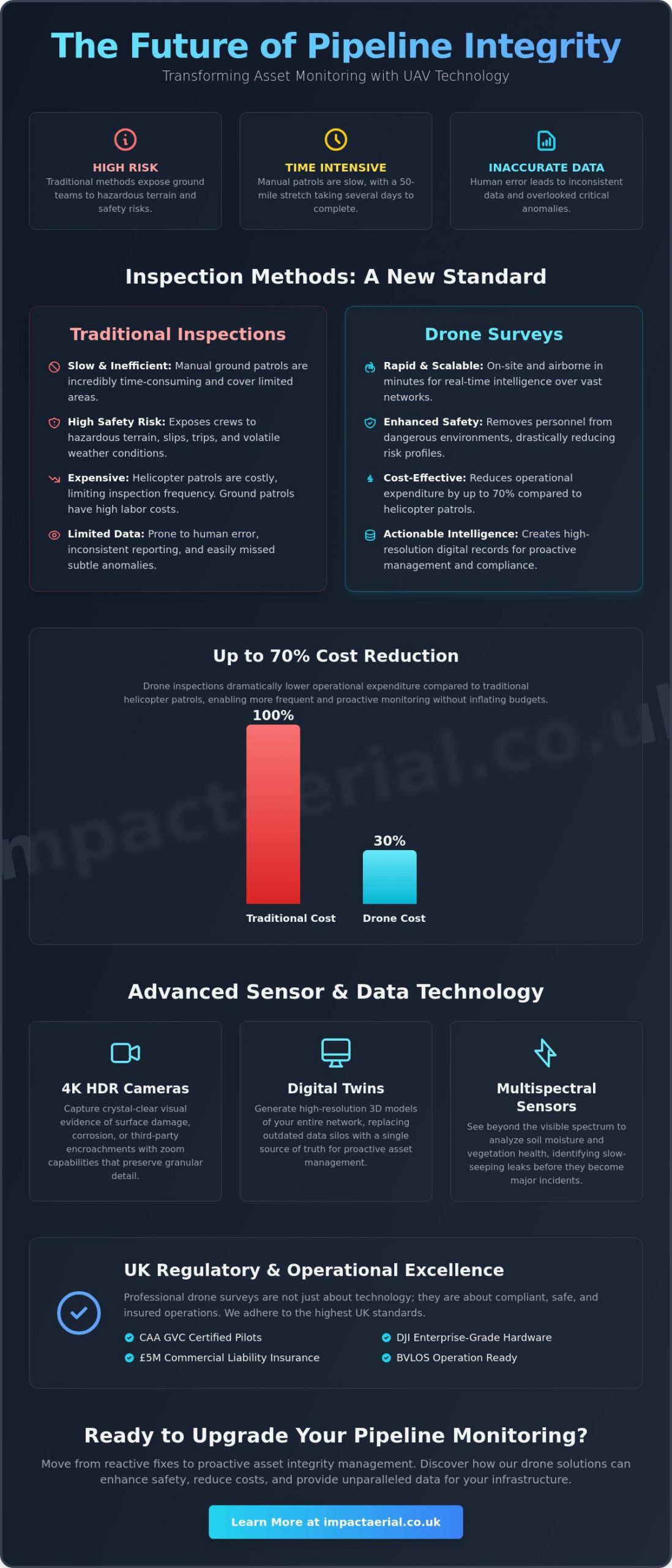
Did you know that drone-based inspections can reduce costs by up to 70% compared to traditional helicopter patrols while delivering faster, more accurate defect detection? For UK asset managers, the challenge of monitoring thousands of miles of infrastructure across hazardous or remote terrain has always been a high-stakes balance of safety and expenditure. You’re likely all too familiar with the slow reporting cycles and the inherent risks of sending ground teams into difficult environments.
Utilizing a professional drone survey for pipeline monitoring is no longer a futuristic concept; it’s a regulatory and operational necessity for maintaining asset integrity in 2026. This guide reveals how commercial drone technology transforms pipeline oversight, providing CAA-compliant monitoring that drastically reduces your risk profile. We’ll explore the latest UK drone classifications, the shift toward Beyond Visual Line of Sight (BVLOS) operations, and how high-resolution digital twins are replacing outdated data silos with actionable, high-tier intelligence.
Key Takeaways
- Learn how transitioning from manual ground patrols to aerial data collection can reduce operational expenditure by up to 70% while significantly improving site safety.
- Understand the technical role of 4K HDR cameras and specialized sensors in identifying structural anomalies and third-party encroachments with high-tier precision.
- Identify the mandatory UK regulatory standards for a drone survey for pipeline monitoring, including CAA GVC certifications and the necessity of £5m commercial liability insurance.
- Discover how high-resolution digital twins and accelerated reporting cycles enable faster leak detection and more proactive asset management across your entire network.
- Explore how commercial-grade DJI Enterprise hardware overcomes the logistical challenges of monitoring critical infrastructure in remote or hazardous UK terrain.
The Evolution of Pipeline Monitoring: Why UAVs are the New Standard
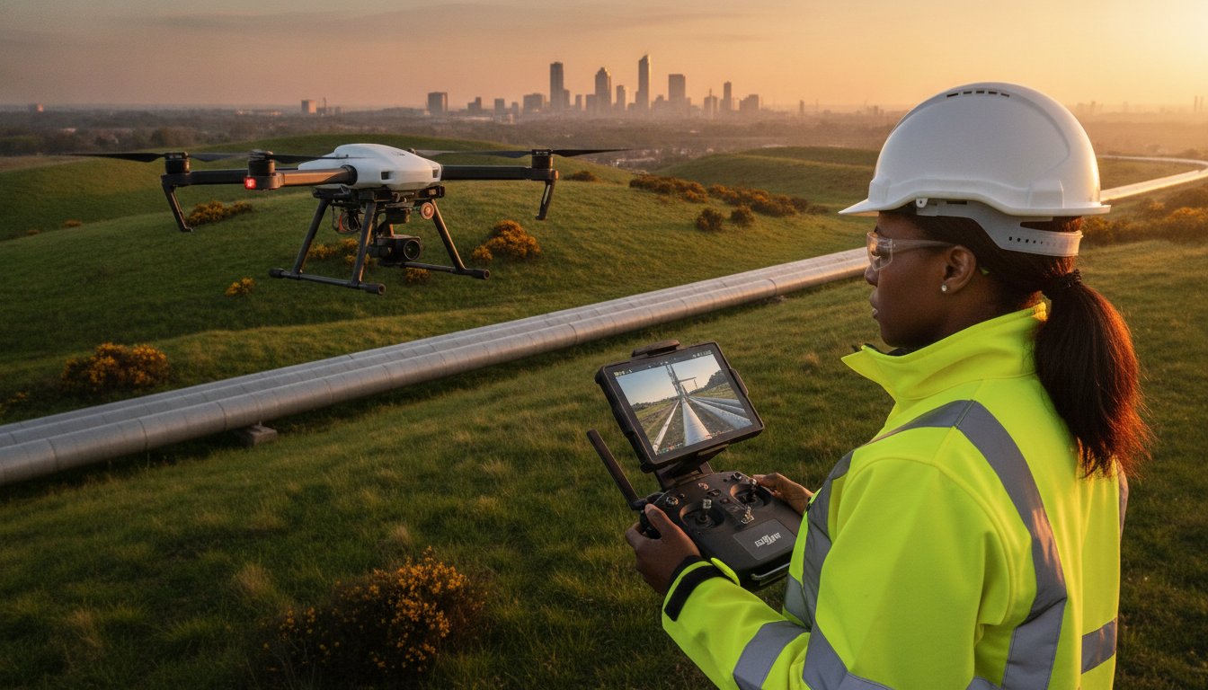
The shift toward unmanned aerial vehicles (UAVs) in the UK utility sector isn’t just about following a trend; it’s a response to the inherent failures of legacy inspection models. For decades, pipeline integrity relied on manual ground patrols, where teams navigated miles of difficult terrain to spot leaks or encroachments. This approach is notoriously slow. It exposes workers to significant safety risks. By integrating a drone survey for pipeline monitoring, operators can now oversee vast networks with a level of precision that was previously impossible.
To better understand this concept, watch this helpful video demonstrating utility inspection workflows:
Modern UAVs utilize advanced remote sensing technology to capture data that the human eye might miss. This transition from reactive “break-fix” cycles to proactive asset integrity management is essential for environmental protection. Research from 2026 indicates that drone-based inspections can reduce costs by 50-70% compared to helicopter patrols. This allows for more frequent checks and earlier leak prevention without inflating operational budgets. The result is a safer, more reliable infrastructure that meets the increasing demands of UK regulators.
Challenges of Traditional Pipeline Inspections
Manual inspections in the UK often involve trekking through remote marshes or across steep, hazardous slopes. These environments pose constant slip and trip hazards for ground crews, especially in volatile weather. Beyond the physical danger, walking a 50-mile pipeline stretch is incredibly time-intensive. It often takes several days to complete a single circuit. Human error also plays a major role in these legacy methods. Manual data recording is frequently inconsistent, and subtle anomalies like slight ground subsidence or early-stage corrosion are easily overlooked during long, fatiguing shifts.
The Strategic Advantage of Aerial Oversight
Aerial platforms offer rapid deployment capabilities that traditional methods can’t match. In the event of a suspected pressure drop or environmental incident, a drone can be on-site and airborne in minutes to provide real-time situational intelligence. This high-frequency monitoring doesn’t require an increase in headcount, making it a scalable solution for growing networks. Perhaps most importantly, every drone survey for pipeline monitoring creates a comprehensive, high-resolution digital record. This permanent data trail is invaluable for regulatory auditing, ensuring that your compliance with UK safety standards is documented with absolute clarity and precision.
Technical Capabilities: Sensor Technology and Data Precision
A professional drone survey for pipeline monitoring relies on a sophisticated payload of specialized sensors designed to identify structural and environmental anomalies with surgical precision. While standard photography has its place, professional utility inspections require high-tier hardware that sees beyond the visible spectrum. We utilize 4K HDR cameras to provide crystal-clear visual evidence of third-party encroachment or surface damage. These high-resolution outputs allow engineers to zoom in on specific assets without losing the granular detail required for informed decision-making. Using such advanced technology ensures that every flight delivers actionable intelligence rather than just raw imagery.
Effective monitoring also requires understanding the ground conditions surrounding the asset. Multispectral sensors analyze soil moisture levels and vegetation health, which often indicate slow-seeping leaks that haven’t yet reached the surface. Because all operations must strictly adhere to UK drone regulations, using calibrated, enterprise-grade equipment ensures that the data collected is both legally compliant and technically sound. This meticulous approach to hardware selection is what separates a basic aerial view from a comprehensive industrial inspection.
Thermal Imaging for Leak Detection
Thermal sensors are indispensable for identifying fluid leaks by detecting subtle temperature variations in the surrounding soil. When a pressurized pipe fails, the escaping substance often changes the thermal signature of the ground above it. In the UK’s temperate climate, these surveys are most effective during periods of high thermal contrast, such as early morning. By integrating thermal data with visual overlays, we create a composite view that makes it easy for maintenance teams to pinpoint the exact location of a subsurface issue. This level of detail is a core component of our professional drone survey services, helping clients mitigate environmental risks before they escalate.
LiDAR and 3D Mapping for Structural Integrity
LiDAR (Light Detection and Ranging) technology is a game-changer for monitoring pipelines in heavily wooded or overgrown areas. Unlike standard photogrammetry, LiDAR pulses can penetrate dense vegetation to map the actual ground surface. This allows us to generate engineering-grade 3D digital twins of pipeline corridors. These models are essential for monitoring long-term subsidence or ground movement that could compromise structural integrity. Achieving the accuracy levels required for these surveys demands meticulous flight planning and high-end processing, resulting in a comprehensive digital asset that serves as a baseline for all future inspections.
The Business Case: Comparing Drone Surveys to Traditional Methods
The financial justification for upgrading legacy inspection protocols is clear. While manual ground patrols and manned helicopter flights were once the industry standard, they carry significant overheads and logistical burdens. Research indicates that a drone survey for pipeline monitoring can be 30-70% cheaper than traditional methods involving rope access, scaffolding, or aircraft. These savings aren’t just found in the direct cost of the survey itself but also in the reduction of support staff and heavy equipment required to facilitate inspections in remote areas.
Asset managers must also consider the broader implications of pipeline infrastructure economics when planning their maintenance budgets. Traditional methods often result in data silos and slow reporting cycles, where anomalies might not be flagged until weeks after the initial site visit. In contrast, aerial surveys accelerate the reporting cycle by providing near-instant access to high-resolution data. This rapid time-to-data allows for quicker decision-making, potentially preventing minor issues from escalating into costly environmental disasters or operational shutdowns.
The environmental impact of these operations is another critical factor. Moving away from fuel-heavy helicopters toward electric-powered UAVs significantly lowers the carbon footprint of your inspection program. This shift supports corporate sustainability goals while maintaining a rigorous oversight schedule that meets the mandated inspection frequencies required by UK authorities.
Operational Efficiency and Speed
Efficiency is built into the workflow of modern aerial surveys. A single flight team can cover dozens of kilometres of pipeline in a single day, a task that would take a ground crew several weeks to complete. We utilize automated flight paths to ensure that data collection is repeatable and consistent across every inspection cycle. This consistency is vital for change detection, allowing engineers to overlay historical data with current imagery to spot subtle shifts in the landscape. Once the flight is complete, our rapid post-production services deliver processed data through secure cloud platforms, ensuring that your team has the information they need without delay.
Risk Mitigation and Safety Standards
Safety remains the primary driver for drone adoption in the industrial sector. By deploying UAVs, you remove personnel from high-risk environments, such as steep embankments, marshlands, or areas with restricted access. Drones also provide an early warning system for third-party encroachments, such as unauthorized construction or vegetation overgrowth that could threaten the asset. In the context of UAV pipeline surveys, risk mitigation is the systematic reduction of physical danger to personnel and the proactive identification of external threats to asset integrity. Implementing a professional drone survey for pipeline monitoring ensures that your safety ROI is maximized by reducing “man-hours at risk” while simultaneously improving the quality of your oversight.
Operational Excellence: Compliance, Safety, and UK Regulations
Operating a drone survey for pipeline monitoring in the UK requires more than just high-end hardware; it demands a rigorous commitment to national aviation laws and industrial safety standards. Compliance is the foundation of every flight we undertake. It ensures that data collection is not only accurate but also legally defensible and safe for all stakeholders involved. For asset managers, partnering with a provider that understands the nuances of the 2026 regulatory landscape is essential for mitigating long-term liability. We approach every mission with a meticulous mindset, prioritizing risk management and official certification above all else.
CAA Regulations and Pilot Certification
The Civil Aviation Authority (CAA) maintains strict oversight of commercial drone operations, particularly those involving critical national infrastructure. It is vital that your chosen provider is CAA GVC certified to operate in the ‘Specific’ category. This qualification allows for more complex maneuvers that fall outside standard recreational limits. As of January 1, 2026, all new drones used for industrial work must also feature UK-specific class marks and mandatory Remote ID technology. For long-distance pipeline oversight, we often operate under specific authorizations for Beyond Visual Line of Sight (BVLOS) flights. This capability is essential for covering vast distances efficiently while maintaining a robust Safety Management System (SMS) and detailed flight logs for every mission.
Insurance is another non-negotiable factor in professional utility work. While basic commercial policies exist, industrial sites typically require a minimum of £5m commercial liability insurance. This coverage provides the necessary reassurance for stakeholders when operating near high-value assets. We also ensure that all data collection adheres to strict GDPR and data protection protocols, safeguarding the privacy of landowners and the security of sensitive infrastructure imagery.
Site Safety and Risk Assessment
Every drone survey for pipeline monitoring begins with exhaustive pre-flight planning. This includes checking for NOTAMs (Notices to Airmen) to identify temporary airspace restrictions and securing all necessary landowner permissions along the route. On-site, we establish clear launch zones and utilize trained spotters to maintain situational awareness. Our hardware choice reflects this focus on reliability. We utilize commercial-grade DJI Enterprise drones equipped with dual-battery systems and redundant flight controllers. These systems ensure that even in the unlikely event of a component failure, the aircraft can return to home safely. If you require an inspection partner that prioritizes these high-tier safety standards, view our professional drone survey services to see how we can support your next project.
Risk assessments for critical infrastructure are particularly detailed. We analyze potential electromagnetic interference and local terrain challenges before the rotors even turn. This methodical approach ensures that we identify and mitigate hazards such as third-party encroachments or hazardous weather patterns early in the planning phase. By combining technical expertise with a safety-first culture, we deliver high-resolution data without compromising the integrity of your site or the safety of the public.
Implementing Drone Monitoring with Impact Aerial
Impact Aerial provides specialized drone survey for pipeline monitoring services designed to address the unique geographical and regulatory challenges of the UK. From our strategic operations base in Birmingham and the West Midlands, we provide nationwide coverage to support critical infrastructure networks. Our approach is built on a foundation of technical precision and meticulous safety protocols, ensuring that every mission delivers high-tier data while remaining fully compliant with national aviation laws. We don’t just capture imagery; we provide a comprehensive oversight solution that integrates seamlessly into your existing asset management workflows.
Our team understands that pipeline integrity is a high-stakes environment where data accuracy is non-negotiable. We utilize commercial-grade DJI Enterprise drones, which offer the redundancy and sensor stability required for industrial surveying. By combining this high-end hardware with a methodical operational style, we ensure that your drone survey for pipeline monitoring delivers a level of detail that manual ground patrols simply cannot match. This commitment to quality and precision is why we are a trusted partner for utility operators across the country.
Our Professional Survey Workflow
Every project begins with an in-depth consultation to define your specific asset monitoring requirements. Whether you need to detect third-party encroachments or perform detailed structural analysis, we tailor our flight parameters to meet those engineering goals. During the precision data capture phase, we utilize 4K HDR visual cameras and thermal sensors to identify anomalies with surgical accuracy. Once the flight is complete, our full-service model extends into expert post-production. We process the raw data to generate detailed reports and 3D mapping for your engineering teams, providing a clear digital record of asset health. This end-to-end drone survey workflow ensures you receive actionable intelligence without the burden of internal data processing.
Why Choose Impact Aerial for Pipeline Oversight?
We distinguish ourselves through a deep commitment to regulatory excellence and technical expertise. Our pilots possess extensive backgrounds in technical surveying, ensuring they understand the industrial context of the data they collect. We maintain a strict adherence to all CAA safety standards and drone services regulations, providing the reassurance and reliability that critical infrastructure projects demand. By choosing a partner that values external validation and high-tier quality, you ensure that your monitoring program is legally compliant and operationally sound. We focus on providing the psychological comfort of knowing your assets are in expert hands, backed by comprehensive insurance and professional certifications.
Contact Impact Aerial today for a professional pipeline survey quote and discover how our aerial data solutions can transform your asset integrity management.
Advancing Your Pipeline Integrity Strategy
Adopting a proactive approach to infrastructure oversight is essential for navigating the complex operational and environmental demands of 2026. A professional drone survey for pipeline monitoring delivers more than just high-resolution imagery; it provides a scalable, data-driven framework for identifying leaks and third-party encroachments before they escalate. By replacing slow, hazardous ground patrols with precision aerial surveys, you can achieve a significant reduction in operational expenditure while improving the quality of your asset integrity records.
Our team at Impact Aerial is committed to delivering these high-tier results through a combination of technical expertise and strict regulatory compliance. We operate a specialized DJI Enterprise Hardware Fleet and employ only CAA GVC Certified Pilots to ensure every mission meets the highest safety benchmarks. With £5m Commercial Liability Insurance as a standard, we offer the reliability and reassurance required for critical national infrastructure projects across the UK. We’re ready to help you elevate your monitoring standards and protect your long-term asset value.
Request a Professional Pipeline Survey Quote from Impact Aerial and take the first step toward a more resilient and efficient network today.
Frequently Asked Questions
Is a drone survey for pipeline monitoring legal in the UK?
Yes, conducting a drone survey for pipeline monitoring is entirely legal in the UK when performed by a CAA-certified operator. Professional pilots must adhere to the 2026 UK drone classifications and hold either an A2 CofC or a GVC certification depending on the weight of the aircraft and the complexity of the flight path. For industrial surveys near critical infrastructure, we operate under specific authorizations that ensure every mission meets the highest safety and legal standards.
Can drones detect gas leaks in underground pipelines?
Drones detect gas leaks by utilizing specialized optical gas imaging (OGI) sensors or laser-based methane detectors. These payloads identify gas plumes that are completely invisible to the human eye or standard cameras. Additionally, thermal sensors can identify subsurface leaks by spotting subtle temperature changes in the soil caused by escaping pressurized fluids. This multi-sensor approach allows for the early detection of leaks before they cause significant environmental damage.
How much does a commercial drone pipeline survey cost?
The cost of a commercial drone survey depends on several variables, including the total distance of the pipeline, the type of sensors required, and the complexity of the terrain. While we don’t provide fixed pricing due to the bespoke nature of utility work, drone-based methods are consistently more cost-effective than traditional alternatives. Utilizing UAVs typically reduces the need for expensive manned helicopter flights or large ground teams, lowering your overall operational expenditure.
What happens if the weather is bad on the day of the survey?
We reschedule flight operations if the weather conditions exceed the safe operating limits of our DJI Enterprise hardware or if the data quality would be compromised. High winds, heavy rain, or thick fog can interfere with both flight stability and sensor accuracy. Our team monitors specialized aviation forecasts closely in the days leading up to a mission. We coordinate with your project managers to ensure the survey takes place during an optimal weather window.
How accurate is the data collected by a pipeline drone?
Data collected by professional drones is exceptionally accurate, often achieving centimetre-level precision when using RTK (Real-Time Kinematic) positioning. When combined with LiDAR sensors, we can generate engineering-grade 3D digital twins that allow for meticulous subsidence monitoring and structural analysis. This level of granularity is significantly higher than what is typically achievable through satellite imagery or manned aircraft inspections, providing a more reliable baseline for asset integrity management.
Do you need permission from landowners to fly over pipelines?
Yes, we require permission from landowners for the take-off and landing of the aircraft on private property. While the CAA regulates the airspace, the practicalities of a drone survey for pipeline monitoring often involve accessing specific land parcels to maintain a safe launch zone. As part of our comprehensive pre-flight planning, we handle the coordination of these permissions to ensure that all operations are conducted with the full consent of local stakeholders.
What is the difference between a visual and a thermal pipeline inspection?
Visual inspections use 4K HDR cameras to identify surface-level issues like third-party encroachment, vegetation overgrowth, or visible structural damage. In contrast, thermal inspections utilize infrared sensors to detect heat signatures and temperature variations. While visual data is excellent for general oversight, thermal imaging is essential for identifying subsurface leaks or insulation failures that aren’t visible to the naked eye. Combining both provides a complete picture of asset health.
Can drones monitor pipelines in urban areas like Birmingham?
Drones can monitor pipelines in urban environments like Birmingham, but these missions require more stringent risk assessments and specific CAA authorizations. Operating in congested areas involves managing complex safety factors and potential signal interference. We utilize redundant flight systems and meticulous site-specific safety protocols to ensure these urban surveys are completed without risk to the public. This allows for efficient oversight of critical infrastructure even in densely populated regions.
