
Professional Drone Mapping Services UK: Precision Aerial Data & 3D Modelling

Professional drone mapping isn’t just about capturing aerial photos; it’s a high-precision data partnership that requires CAA-certified expertise and survey-grade technology to be legally viable in the UK. You’re likely already aware that traditional land surveys often result in slow turnaround times and significant safety risks during manual inspections. It’s frustrating when amateur operators deliver low-resolution data that doesn’t meet professional standards. By choosing expert drone mapping services uk, you can overcome these hurdles, potentially reducing infrastructure inspection costs by up to 55% compared to traditional methods.

Selecting the right drone mapping services uk requires a clear understanding of the technical outputs available and how they serve specific project goals. Raw aerial photography is qualitative; it shows you what a site looks like. In contrast, professional drone mapping delivers quantitative data by converting thousands of individual images into georeferenced assets like orthomosaics, 3D point clouds, and terrain models. To understand the sophisticated processing behind these models, you can discover more about Drone Mapping and Photogrammetry Services to see how they provide measurable insights. Each deliverable serves a distinct purpose, from measuring boundary lines to calculating the exact volume of material moved on a construction site.

In this guide, you’ll learn how to master the complexities of aerial data collection to acquire actionable 2D and 3D models quickly. We’ll ensure your projects remain 100% compliant with the latest January 2026 regulations, including UK class markings and the mandatory green flashing lights for night operations. We’ll cover the essential hardware requirements and the integration of AI-driven workflows that are currently transforming the UK’s 1.05 billion dollar UAV market. By the end, you’ll understand how to leverage technical excellence to reduce project costs and guarantee safety on every site.

Key Takeaways

  • Understand the technical distinction between 2D orthomosaic maps and 3D point clouds to select the most effective data output for your project requirements.
  • Learn how to achieve survey-grade accuracy by leveraging Real-Time Kinematic (RTK) positioning and strategically placed Ground Control Points.
  • Ensure full legal compliance by identifying professional drone mapping services uk that strictly adhere to the 2026 CAA regulatory framework and safety standards.
  • Develop a robust checklist for evaluating potential partners based on their enterprise-grade hardware stack and proven commercial sector expertise.

What Are Drone Mapping Services and Why Are They Essential for UK Projects?

Drone mapping services uk represent a sophisticated branch of aerial photogrammetry. It’s a process where unmanned aerial vehicles (UAVs) capture georeferenced, high-resolution imagery to create precise digital representations of the physical world. By 2026, the UK market has matured, moving decisively away from qualitative site photos toward quantitative geospatial data. This data provides measurable, survey-grade insights that are essential for modern project management. The UK UAV market reached a valuation of approximately USD 1.05 billion in 2025; this growth is fueled by the demand for high-density data that traditional methods simply can’t match.

The primary advantage of professional UAV mapping lies in the significant reduction of “boots on the ground.” Manual inspections often involve high-risk environments, such as fragile roofs, live construction sites, or steep embankments. Drone technology removes personnel from these hazards while simultaneously increasing the volume of data points collected. Research indicates that drone-based infrastructure inspections can be up to 55% cheaper than traditional manual methods. This efficiency doesn’t just save money. It provides a level of site oversight that was previously impossible without massive logistical overhead and prolonged timelines.

The Evolution of Aerial Data Collection

Historically, large-scale mapping required expensive manned aircraft or slow, ground-based theodolite surveys. The broader field of Aerial survey has been transformed by the introduction of DJI Enterprise technology and high-end sensors. These systems offer commercial-grade reliability and precision that amateur equipment lacks. We’ve seen a shift from processing times that took weeks to rapid, 24-hour turnarounds. Real-time data access allows project managers to make informed decisions based on current site conditions rather than outdated reports from the previous month.

Key Industries Benefiting from Precision Mapping

The adoption of UAV mapping is occurring at record rates across several UK sectors. In construction, roughly 67% of companies now use drones for site monitoring and volumetric calculations. This allows for precise tracking of earthworks and material stockpiles without halting site operations. In the property and land sector, these services resolve boundary disputes and provide accurate topographical assessments for developers. Environmental agencies also rely on this data for flood risk modelling and tracking coastal erosion. They use the high-resolution outputs to predict changes in the landscape with millimetre precision, ensuring that heritage sites and natural habitats are protected through data-driven strategies.

The Technical Edge: Understanding Orthomosaics, 3D Models, and LiDAR

Selecting the right drone mapping services uk requires a clear understanding of the technical outputs available and how they serve specific project goals. Raw aerial photography is qualitative; it shows you what a site looks like. In contrast, professional drone mapping delivers quantitative data. This involves converting thousands of individual images into georeferenced assets like orthomosaics, 3D point clouds, and terrain models. Each deliverable serves a distinct purpose, from measuring boundary lines to calculating the exact volume of material moved on a construction site.

2D Orthomosaics: More Than Just a Map

An orthomosaic is a high-resolution, geometrically corrected map created by stitching together thousands of 4K HDR images. Unlike a standard photograph, an orthomosaic has a uniform scale. This means you can measure distances and surface areas directly on your screen with survey-grade precision. Urban planners and estate managers use these maps to oversee large-scale developments where every centimetre counts. Because the images are orthorectified to account for topographic relief and lens distortion, the resulting map provides a true “planimetric” view of the entire site.

3D Digital Twins and Volumetric Analysis

While 2D maps are vital for layout, 3D digital twins provide an immersive replica of structures and landscapes. By generating millions of data points, we create 3D point clouds that assist in structural health monitoring and heritage conservation. For those managing earthworks, this technology enables precise volumetric analysis. You can calculate stockpile volumes quickly without the safety risks of manual surveying. If you need consistent oversight for your project, our professional construction site monitoring provides the high-density data required for accurate reporting.

Choosing between photogrammetry and LiDAR depends on your terrain. Photogrammetry is excellent for open sites with clear visibility. However, if your project involves dense vegetation or forest canopy, LiDAR is the superior choice. LiDAR sensors emit light pulses that penetrate through leaves to reach the ground, allowing for the creation of an accurate Digital Elevation Model (DEM) even in overgrown areas. In contrast, a Digital Surface Model (DSM) includes all features, such as trees and buildings, which is more suited for urban site planning.

Integration with CAD, BIM, and GIS Workflows

The true value of drone data lies in its interoperability. We provide data in industry-standard formats including .OBJ, .LAS, .TIFF, and .DXF. This allows for seamless integration into your existing workflows, whether you’re using Autodesk Revit for Building Information Modelling (BIM) or ArcGIS for geographical analysis. By feeding “as-built” drone data directly into your design software, you can identify discrepancies between the plans and the physical reality of the site in real-time. All operations are conducted in strict accordance with UK Civil Aviation Authority (CAA) regulations, ensuring that your high-precision data is captured safely and legally.

Professional Drone Mapping Services UK: Precision Aerial Data & 3D Modelling

Accuracy, Safety, and Compliance: The Professional Standard

Professionalism in drone mapping services uk hinges on the integrity of the data and the safety of the operation. While amateur pilots can capture visually impressive photos, they often lack the technical infrastructure to provide survey-grade accuracy. High-precision mapping requires a robust combination of advanced hardware, rigorous flight protocols, and strict adherence to the latest UK aviation laws. This section clarifies the technical and legal standards that separate professional data partnerships from basic aerial photography.

Achieving Centimetre-Level Precision

Standard consumer drones rely on basic GPS, which typically results in a horizontal error margin of several metres. This level of drift is unacceptable for construction site monitoring or topographical assessments. We use RTK-enabled (Real-Time Kinematic) hardware, such as the Mavic 3 Enterprise, to achieve centimetre-level relative accuracy. RTK technology uses a ground-based station to provide real-time corrections to the drone’s positioning data. To ensure absolute accuracy—anchoring the digital model to its exact real-world coordinates—we use Ground Control Points (GCPs). These physical markers are measured with high-precision GNSS rovers, acting as an anchor that prevents digital “drift” and ensures your 2D and 3D assets are technically sound.

Regulatory Compliance: CAA GVC and Beyond

Operating a commercial drone in the UK involves navigating a complex regulatory landscape that changed significantly on January 1, 2026. Every mission we conduct remains within the pilot’s Visual Line of Sight (VLOS) and below the 400ft (120m) altitude limit. Being a CAA GVC certified operator demonstrates that our pilots have the formal qualifications to fly in more challenging environments, including urban areas and Restricted Area Services (RAS). Compliance in 2026 also requires:

  • UK Class Markings: Ensuring all aircraft carry the correct UK0 to UK6 markings for their weight and capability.
  • Remote ID: Drones must broadcast the operator’s ID to comply with current safety standards.
  • Night Operations: The mandatory use of a green flashing light for any flights conducted after sunset.
  • Operator and Flyer IDs: Maintaining valid registrations with the CAA at all times.

Risk mitigation is our primary priority. We maintain £5 million in commercial liability insurance as an industry baseline, providing our clients with absolute reassurance during complex site surveys. Every flight is preceded by a formal risk assessment and followed by detailed flight logs. This meticulous approach ensures that your project data is not only accurate but is also captured within a framework of total legal and operational security. By choosing a compliant specialist, you eliminate the legal risks associated with unlicensed operators and ensure that your data is admissible for official planning and design workflows.

Choosing the Right Drone Mapping Partner: A UK Business Checklist

Selecting a partner for drone mapping services uk requires more than just checking for a basic flyer ID. You’re commissioning a technical data partnership that directly impacts your project’s bottom line. The difference between a creative agency and a technical consultant lies in their ability to deliver actionable insights rather than just raw imagery. When vetting potential operators, prioritize those with proven experience in your specific sector, whether that’s construction site monitoring or commercial property surveys. A specialist understands the nuances of site logistics and the specific data density required for your industry.

Your checklist should begin with the hardware and software stack. Enterprise-grade sensors, such as those found on DJI Enterprise platforms, are non-negotiable for professional outputs. These systems provide the thermal sensitivity required for PV solar farm surveys and the high-resolution HDR imagery needed for meticulous structural inspections. Ask potential partners about their data security protocols. Sensitive project data must be handled with the same level of confidentiality and technical security as any other corporate asset. It’s not just about the flight; it’s about the integrity of the information you receive.

Evaluating Credentials and Insurance

Compliance is a baseline, but professional indemnity is what protects your business. While standard public liability is common, specialist drone mapping services uk should carry at least £5 million in commercial liability coverage. Verify their CAA Operational Authorisation (OA) status to ensure they can legally operate in complex environments. Local knowledge is also a significant asset. For instance, an operator familiar with the airspace and local authorities in Birmingham and the West Midlands can navigate site logistics more efficiently, reducing the risk of project delays. This regional expertise ensures that site-specific risks are managed before the drone even leaves the ground.

Data Deliverables and Turnaround Times

Clearly define your file format requirements before the mission begins. Whether you need .LAS point clouds for BIM or high-resolution .TIFF files for GIS, your partner must have the post-production capabilities to deliver these. You should also account for the ‘Processing Gap.’ High-quality photogrammetry involves complex stitching and georeferencing that takes time to execute correctly. Don’t settle for rushed results that compromise accuracy. Request sample data from previous projects to verify that their resolution and accuracy standards align with your technical needs.

Ready to secure survey-grade data for your next project? You can contact our expert drone mapping team to discuss your specific site requirements today.

Impact Aerial: Precision Drone Mapping Services Across the UK

Centrally based in Birmingham, Impact Aerial provides a methodical approach to data collection that ensures your project remains on schedule and within budget. We deliver professional drone mapping services uk by combining technical proficiency with a deep understanding of UK aviation law. Our pilots aren’t just operators; they’re technical specialists who prioritize site safety and data integrity above all else. This regional strength allows us to serve the entire UK with a rapid response time, ensuring that local knowledge informs every flight plan. Our £5 million commercial liability insurance acts as a fundamental pillar of our service, providing the psychological comfort and tangible security that enterprise clients require for high-stakes projects.

Why Impact Aerial is the Trusted Choice

Our commitment to the highest safety standards is reflected in our meticulous planning and adherence to the latest CAA regulatory frameworks. We have extensive experience in high-precision sectors, including drone commercial property surveys and detailed construction site monitoring. For clients in the renewable energy sector, our PV solar farm thermal surveys provide critical data on panel efficiency and structural health. We leverage DJI Enterprise 4K HDR drones and RTK precision to ensure that every deliverable, from a 2D orthomosaic to a complex 3D point cloud, meets the most stringent accuracy standards. This technical adeptness is balanced with a focus on no-hassle project management, where we handle everything from initial risk assessments to the final post-production editing.

Get Started with Your Precision Mapping Project

The path to survey-grade data begins with a consultation designed to align our hardware and software capabilities with your specific project goals. We don’t just deliver raw files; we provide actionable geospatial data that integrates seamlessly into your existing CAD, BIM, or GIS workflows. Our process is structured to remove the burden of logistical planning from your team. We manage flight permissions in restricted areas and coordinate with local authorities to ensure 100% legal compliance. By choosing a partner that values industry standards and external validation, you ensure that your site data is technically sound and legally robust. We’re ready to assist with your next aerial filming project or structural inspection.

Contact Impact Aerial for a professional drone mapping consultation today.

Advancing Your Project with Survey-Grade Aerial Intelligence

Professional drone mapping services uk have evolved into a critical component of modern infrastructure and project management. By transitioning from qualitative photography to quantitative geospatial data, you gain a level of site oversight that traditional methods simply can’t match in terms of speed or data density. The integration of high-resolution orthomosaics and 3D digital twins ensures that every measurement is technically sound and ready for your BIM or GIS workflows.

Impact Aerial provides this technical edge through meticulous planning and the use of enterprise-grade DJI RTK hardware. Our CAA GVC certified pilots operate with strict adherence to the latest safety protocols, backed by £5m commercial liability insurance for your total reassurance. Whether you’re managing a complex construction site or conducting a meticulous thermal survey, our expertise ensures a seamless transition from raw data collection to high-tier output. Experience the benefits of precision data and expert site oversight on your next development.

Request a Professional Drone Mapping Quote today to see how our precision mapping can streamline your next project. We’re ready to help you achieve your operational goals with absolute accuracy and safety.

Frequently Asked Questions

What is the typical accuracy of a drone mapping survey?

Professional drone mapping surveys typically achieve a relative horizontal accuracy of 1 to 2 centimetres when using RTK-enabled hardware. Absolute accuracy, which pins the data to a specific point on the earth, is achieved by integrating Ground Control Points (GCPs) measured with high-precision GNSS rovers. This ensures that the resulting digital models are technically viable for complex engineering and construction applications.

How long does it take to complete a drone mapping project?

The on-site data collection for most drone mapping services uk projects is completed within a few hours or a single working day. However, the processing gap for high-resolution photogrammetry requires sophisticated software to stitch thousands of images into a cohesive model. You can generally expect to receive your finalised 2D or 3D deliverables within 24 to 72 hours after the flight mission is concluded.

Do I need to be on-site during the drone mapping flight?

Your presence on-site during the flight isn’t mandatory, though it can be beneficial for providing site access and discussing specific areas of interest. Our pilots conduct comprehensive pre-flight risk assessments and manage all CAA-compliant protocols independently. We provide a full briefing before the mission and deliver the data digitally, allowing you to focus on your core project management tasks without interruption.

What weather conditions prevent drone mapping from taking place?

Flight operations are restricted by precipitation, high winds, and low visibility. Most enterprise drones are rated for winds up to approximately 22mph, but for high-precision mapping, we prefer calmer conditions to ensure sensor stability. If the forecast indicates rain, snow, or heavy fog, we’ll coordinate a reschedule to ensure the data quality remains high and the aircraft remains within safe operational limits.

Can drone mapping data be used for legal boundary disputes?

Drone mapping data provides high-resolution visual evidence and precise measurements that are often used to support boundary assessments. While it’s an excellent tool for topographical assessments and site documentation, it doesn’t replace the legal standing of a chartered land surveyor. It serves as a powerful quantitative supplement to traditional land registry documents and can be used as supporting evidence in professional legal reviews.

What is the difference between an orthomosaic and a standard aerial photo?

A standard aerial photo is a single perspective that contains lens distortion and lacks a uniform scale. An orthomosaic is a geometrically corrected map created by stitching thousands of overlapping images together. Because it’s orthorectified to account for topographic relief, every pixel is georeferenced. This allows you to perform accurate distance and area measurements directly on the digital file with survey-grade precision.

How much does a professional drone mapping service cost in the UK?

The cost of drone mapping services uk varies based on the site’s scale, the required data density, and the complexity of the terrain. Large-scale construction site monitoring or LiDAR surveys require more processing time and higher-tier hardware than basic property surveys. You should consult with an operator to receive a tailored quote that reflects your specific accuracy requirements and the required file formats for your software.

Are there privacy concerns with drone mapping in residential areas?

We operate in strict accordance with CAA regulations and UK GDPR guidelines to protect privacy in residential areas. Professional pilots use flight planning software to ensure the camera only captures the target site, and any incidental data of persons or vehicles is typically blurred or removed during the post-production phase. Our operations are transparent and conducted with the necessary permissions to ensure community safety and legal compliance.
Drone Mapping for Urban Planning: A Professional Guide to City Development in 2026

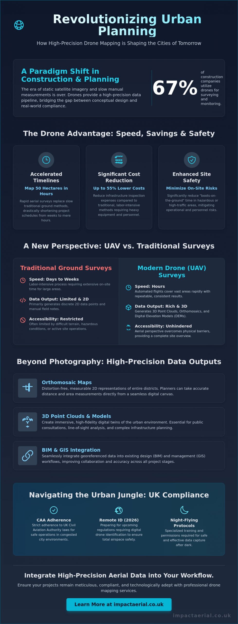
With 67% of construction companies now utilizing drones for site surveying and progress monitoring, the era of relying on static satellite imagery or slow manual measurements has officially ended. You likely feel the pressure of rapid urbanization and the need for faster project approvals while staying strictly compliant with the latest CAA regulations. Utilizing drone mapping for urban planning is no longer just about capturing aerial views; it’s a high-precision data pipeline that bridges the gap between conceptual design and real-world compliance.

Discover how high-precision aerial data accelerates urban development, ensures regulatory adherence, and provides the actionable insights needed for smarter city planning. This guide examines the technical requirements for survey-grade accuracy, including RTK and PPK capabilities, alongside the essential 2026 UK drone regulations like Remote ID and night-flying protocols. You’ll learn how to leverage highly accurate 3D models for public consultations and implement cost-effective site monitoring that can reduce infrastructure inspection expenses by up to 55%. We’ll provide the authoritative framework for integrating advanced aerial technology into your professional workflow, ensuring your projects remain meticulous, compliant, and technologically adept.

Key Takeaways

  • Accelerate project timelines by replacing traditional ground methods with rapid aerial surveys capable of mapping 50 hectares in just hours.
  • Utilize high-precision 3D point clouds and distortion-free orthomosaic maps to provide measurable data for complex urban infrastructure projects.
  • Ensure strict adherence to UK aviation law by understanding the specific certifications and safety protocols required for operations in congested city environments.
  • Improve collaboration across design teams by integrating georeferenced drone mapping for urban planning data into BIM and GIS workflows.
  • Optimize site monitoring and public consultations with actionable data that bridges the gap between conceptual design and regulatory approval.

Transforming Cityscapes: Why Drone Mapping is Essential for Modern Urban Planning

Drone mapping for urban planning is the sophisticated process of capturing georeferenced sensor data to produce high-resolution 2D and 3D outputs. Unlike traditional aerial survey methods, modern UAV technology provides a granular level of detail that satellite imagery simply cannot match. This shift is fundamental as cities move from reactive management to proactive, data-driven planning. By utilizing real-time data, developers and local authorities can make informed decisions based on current site conditions rather than outdated records.

To better understand how this technology integrates into the construction and planning phase, watch this helpful video:

In 2026, the pressures of rapid urbanization and stringent sustainability targets have made precision essential. Infrastructure is under constant strain. High-density city projects require a level of accuracy that ground-based teams struggle to provide within tight deadlines. While satellite imagery serves broad purposes, its resolution is often insufficient for the meticulous demands of modern city development. Drones bypass these limitations. They offer a reliable and cost-effective alternative for capturing site-specific information without the delays associated with orbital passes or cloud cover.

The Evolution of Urban Data Collection

The industry has transitioned from labor-intensive manual land surveys to automated UAV flight paths. These pre-programmed routes ensure consistent data coverage and repeatable results, which are vital for long-term monitoring. Modern hardware captures high-resolution 4K HDR imagery, revealing structural details and environmental factors that were previously invisible. This unique perspective provides a comprehensive overview of a site’s topography and existing assets. It allows ground teams to focus on specialized tasks rather than routine measurements.

Key Benefits for Stakeholders and Developers

One of the primary advantages of drone mapping for urban planning is the acceleration of the planning permission process. Providing local authorities with accurate, up-to-date site visualizations reduces ambiguity and speeds up approval cycles. Safety remains a paramount concern in any urban environment. By utilizing drones, developers can significantly reduce “boots-on-the-ground” time in hazardous or high-traffic areas, mitigating operational risks. Research indicates that using drones for infrastructure inspections can lead to a 55% cost reduction compared to traditional methods.

Public engagement has also seen a significant transformation. Stakeholders can now interact with immersive 3D city models that clearly illustrate the impact of proposed developments. These models provide a transparent and accessible way for the public to understand changes to their environment. This fosters trust and leads to smoother consultation phases. Through meticulous data processing, these surveys become a cornerstone of successful city development projects.

Beyond Photography: High-Precision Outputs for Urban Infrastructure

While high-resolution imagery is a staple of modern city development, the true value of drone mapping for urban planning lies in the technical datasets generated during the post-production phase. Professional UAV operations produce orthomosaic maps, which are distortion-free, measurable 2D representations of entire districts. These maps allow planners to take accurate distance and area measurements directly from their screens. By stitching together thousands of georeferenced images, we create a seamless digital canvas that serves as a reliable foundation for site analysis.

Precision goes deeper than 2D imagery. 3D point clouds generate millions of individual data points, creating a high-density digital replica of urban structures. These models allow for precise volumetric analysis and the creation of digital twins. A digital twin acts as a virtual testing ground where planners can stress-test designs against environmental factors before any ground is broken. This level of drone data for urban planning ensures that every decision is backed by empirical evidence rather than estimates.

Topographical and Volumetric Analysis

Accurate elevation data is critical for assessing drainage and flood risks in built-up areas. Using advanced drone survey techniques, teams can calculate earthworks and stockpiles with high precision. The Ground Sample Distance (GSD) determines the level of detail; a lower GSD means higher resolution and better accuracy for urban mapping. Even underground utility corridors can be identified through surface-level indicators captured in high-definition, providing a clearer picture of existing site constraints.

3D Visualisation and Public Consultation

Raw data becomes a powerful communication tool when transformed into interactive models. During community planning meetings, these 3D visualisations help stakeholders grasp the scale and impact of a project. Planners can simulate “rights to light” scenarios and identify potential view-path obstructions with surgical accuracy. For a more immersive approach, developers often use virtual tour experiences to showcase proposed developments to investors and the public. If you need to document every stage of your project’s lifecycle, our commercial drone services provide the ongoing data required for meticulous oversight.

Drone Mapping for Urban Planning: A Professional Guide to City Development in 2026

Data Accuracy and Efficiency: Comparing UAV Surveys to Traditional Methods

Traditional land surveying has long been the standard for city development, yet it often struggles to keep pace with the rapid requirements of 2026. Implementing drone mapping for urban planning allows for rapid data acquisition without the logistical bottlenecks of traditional ground-based surveying. While a manual ground crew might spend weeks traversing a complex site, a professional UAV can map 50 hectares in just a few hours. This speed doesn’t sacrifice quality; it provides a comprehensive dataset that is immediately ready for analysis.

Operational costs are significantly reduced by removing the need for heavy equipment. Traditional methods often require extensive scaffolding or disruptive road closures to gain necessary vantage points in high-density areas. Drones eliminate these overheads by operating from the air, maintaining safety while keeping surveyors out of active construction zones or high-traffic corridors. This approach ensures that your project remains on schedule without compromising the safety of your personnel or the public.

A deeper understanding of the reveals how these digital outputs integrate seamlessly into modern project management. By achieving centimetre-level precision through Real-Time Kinematic (RTK) technology, planners can trust that their digital models reflect the absolute reality of the site. This meticulous level of detail is vital for ensuring that new infrastructure aligns perfectly with existing urban assets.

The ROI of Drone Integration

The financial benefits of drone data extend far beyond the initial survey. Identifying site discrepancies early in the design phase prevents costly “re-work” during the construction stage. Drones provide a more economical solution for urban mapping than manned aircraft because they eliminate high fuel costs and complex flight logistics for localized projects. Furthermore, digital data archival creates a historical record of the site, which assists in long-term asset management and future maintenance planning.

Technical Precision: RTK vs. PPK

Achieving survey-grade accuracy requires a choice between two primary satellite positioning methods. Real-Time Kinematic (RTK) provides instant geospatial accuracy by connecting to a base station or network during flight. In “urban canyons” where satellite signals may be obstructed by tall buildings, Post-Processed Kinematic (PPK) is often the preferred choice. PPK allows for the correction of positioning data after the flight is completed, ensuring high-tier quality even in challenging environments. Professional operators often use Ground Control Points (GCPs) as an additional layer of verification, reinforcing the reliability of the final survey data.

Operating drone mapping for urban planning within a city environment requires a level of oversight far beyond standard aerial photography. The Civil Aviation Authority (CAA) maintains strict frameworks for flights in “Congested Areas,” which are defined as any area used substantially for residential, commercial, industrial, or recreational purposes. For a project to be legal and safe, pilots must possess the correct certifications to operate in proximity to buildings and people. This regulatory landscape ensures that the high-precision data collection required for city development is conducted without compromising public safety.

Risk mitigation is a cornerstone of professional urban operations. While basic insurance might suffice for open fields, the industry standard for commercial city development projects is £5 million in public liability insurance. This provides the necessary reassurance for stakeholders, developers, and local authorities. Additionally, data protection is paramount. Adhering to GDPR when mapping residential areas involves meticulous planning to ensure that identifiable personal data, such as faces or vehicle registrations, is managed or redacted during the post-production phase.

The Importance of a UK Drone License

There’s a critical distinction between a basic Flyer ID and a professional qualification like the General Visual Line of Sight Certificate (GVC). Commercial urban operations often necessitate a GVC-certified pilot to handle complex airspace requirements. These professionals are trained to manage transitions in industry standards, such as the 2026 requirements for Remote ID broadcasting and UK class markings. In high-risk environments, we often secure specific “Operating Authorisations” from the CAA, allowing for flights that fall outside standard category limits. This expertise is vital when working near restricted zones like hospitals, helipads, or major transport hubs.

Safety Protocols in Densely Populated Areas

Safety is never an afterthought; it’s the foundation of every mission. Every deployment begins with a meticulous pre-flight site assessment to identify hazards and establish emergency landing zones. We utilize DJI Enterprise hardware equipped with redundant systems, such as dual batteries and obstacle avoidance sensors, to ensure fail-safe operations even in signal-heavy urban canyons. Effective communication is also essential. We coordinate with local authorities and the police before every mission to ensure transparency and compliance. If you require a partner who prioritizes regulatory compliance and technical precision, explore our commercial property survey services to see how we manage complex urban sites.

Implementing Drone Data: From Aerial Surveys to BIM Integration

The final stage of drone mapping for urban planning involves converting raw sensor data into actionable assets for design and architecture teams. This process is often referred to as the “Scan-to-BIM” workflow. It bridges the gap between the physical site and the digital building information model. By capturing the existing environment with survey-grade accuracy, planners can populate Revit or AutoCAD with precise site conditions. This eliminates the guesswork often associated with traditional site drawings and ensures that the conceptual design is grounded in reality.

Aerial data is exported in various industry-standard formats to ensure compatibility across different software ecosystems. High-density point clouds are typically delivered as .las or .laz files, while orthomosaic maps are provided as georeferenced .tiff files compatible with ArcGIS and other GIS platforms. These datasets allow global teams to collaborate via cloud-based platforms, ensuring every stakeholder has access to the same high-resolution site replica. This centralized data approach reduces communication errors and streamlines the entire development lifecycle from the initial survey to final construction.

Seamless Workflow Integration

Converting 3D point clouds into workable CAD architectural drawings is a meticulous process. It involves extracting geometric data from millions of points to create clean, structured vectors that designers can manipulate. Orthomosaics serve as highly accurate basemaps for new urban zoning projects, providing a visual context that standard maps lack. We also utilize advanced processing techniques where AI classifies land use and vegetation from drone datasets. This automation allows for faster environmental impact assessments and more efficient site categorization, which is vital for meeting modern sustainability targets.

Choosing a Professional Drone Service

The quality of your urban data depends heavily on the hardware and expertise of the operator. Professional equipment like the DJI Mavic 3 Enterprise is essential for capturing the fine urban detail required for architectural planning. It’s not just about the flight; the value of post-production editing cannot be overstated. Clear, professional planning presentations require data that has been cleaned of noise and correctly georeferenced to national grid standards. This level of precision provides the psychological comfort and tangible benefits that professional stakeholders demand.

Impact Aerial is the partner of choice for UK-wide urban data collection. We combine technical expertise with a strict adherence to CAA safety protocols, providing the reassurance that your project is in expert hands. Our specialized services, including construction site monitoring and commercial property surveys, ensure your data is both accurate and compliant. Contact Impact Aerial for a consultation on your urban mapping project to discover how our high-end outputs can accelerate your development cycle.

Future-Proofing City Development with Precision Data

Adopting drone mapping for urban planning is no longer a luxury; it’s a technical necessity for developers who require survey-grade accuracy and seamless BIM integration. We’ve explored how high-resolution orthomosaics and 3D point clouds provide the foundational data needed for modern infrastructure, all while significantly reducing the logistical risks associated with traditional ground surveys. By moving towards automated, data-centric processes, your planning department can ensure faster approval cycles and more transparent public consultations.

Success in the urban landscape requires more than just high-end hardware. It demands a meticulous approach to regulation and safety. Our team utilizes a commercial-grade DJI Enterprise Fleet and operates under the expertise of CAA GVC Certified Pilots. We provide the psychological comfort of £5m Commercial Liability Insurance, ensuring your project remains compliant with the most stringent UK aviation standards. Transitioning your workflow to include professional aerial data will position your projects at the forefront of 2026 city development standards.

Request a Professional Urban Mapping Quote to secure the high-tier quality and authoritative data your next project deserves. We look forward to helping you build the cities of the future with precision and reliability.

Frequently Asked Questions

Is drone mapping legal in busy city centres like London or Birmingham?

Yes, drone mapping is legal in busy city centres when conducted by a CAA-certified operator holding the correct qualifications. Professional pilots must hold a General Visual Line of Sight Certificate (GVC) and often require specific Operating Authorisations for congested areas. We ensure all flights comply with current 2026 regulations, including Remote ID broadcasting and night-flying light requirements, to maintain the highest safety standards.

How accurate is drone mapping compared to traditional land surveying?

Drone mapping is highly accurate, providing centimetre-level precision that is comparable to traditional land surveying for most urban applications. By using RTK-enabled hardware and established Ground Control Points (GCPs), we verify the geospatial integrity of every pixel. This meticulous approach ensures that the digital outputs are reliable for architectural design and infrastructure engineering.

What kind of data files will I receive from an urban drone survey?

You’ll receive a variety of industry-standard files tailored to your specific software requirements. Typical outputs include georeferenced orthomosaic maps in .tiff format, 3D point clouds as .las or .laz files, and textured 3D meshes in .obj or .fbx formats. These files are ready for immediate import into GIS or CAD platforms, providing a seamless transition from the aerial survey to your internal planning workflow.

Can drones map areas with high-rise buildings and “urban canyons”?

Mapping high-rise environments and urban canyons is achievable through advanced positioning techniques. We utilize Post-Processed Kinematic (PPK) workflows to overcome the signal multipath issues common in densely built areas where tall structures might block satellite signals. This ensures that the final 3D model maintains the high-tier quality and geospatial accuracy required for professional planning applications.

How long does it take to process drone data into a 3D model?

Data processing for drone mapping for urban planning has advanced significantly, with standard projects typically completed within 24 to 48 hours. While simple maps are ready in hours, complex 3D models involving 10,000 to 20,000 images are now processed overnight. This rapid turnaround allows developers to move from site survey to design review in a fraction of the time required by traditional methods.

Do I need to notify the police or local council before a drone mapping flight?

Formal notification is not always a legal requirement under CAA rules, but we coordinate with local authorities as part of our standard safety protocol. This proactive communication helps manage public awareness and ensures that local emergency services are informed of our flight window. Our meticulous pre-flight planning includes identifying all relevant stakeholders to ensure a smooth, compliant operation.

What happens if the weather is poor on the day of the mapping flight?

Operations are rescheduled if weather conditions, such as high winds or heavy rain, compromise the safety of the flight or the quality of the data. We use professional meteorological tools to monitor local forecasts and provide regular updates to our clients. A safety-first approach ensures that we only fly when we can guarantee the high-tier precision and reliability our clients expect.

How does drone mapping help with environmental impact assessments (EIA)?

Drone mapping for urban planning assists with EIAs by providing precise elevation models for flood risk analysis and high-resolution imagery for habitat mapping. These digital datasets allow planners to visualize the environmental impact of proposed structures with surgical precision. This data-centric approach ensures that sustainability targets are met while identifying potential ecological constraints early in the development lifecycle.

What is a Survey Drone? A Complete Guide for Professionals

Navigating the world of aerial surveying can feel overwhelming. With complex terms like photogrammetry and LiDAR, and critical questions around CAA regulations, it’s difficult to know where to start. You understand the technology offers a competitive edge, but what truly separates a consumer gadget from a professional survey drone capable of delivering centimetre-accurate data? This uncertainty is a common challenge for industry leaders looking to leverage this powerful tool for their projects.

This comprehensive guide is designed to provide clarity and build your confidence. We will demystify the core technology that defines a survey-grade drone, explaining the distinct capabilities of different sensors-from high-resolution cameras for photogrammetry to advanced LiDAR and thermal systems. We’ll also provide a practical framework for deciding between investing in an in-house drone program and partnering with a certified operator. By the end, you will have a clear, professional understanding of how to harness aerial data with the assurance of accuracy, reliability, and full regulatory compliance.

What Defines a ‘Survey Drone’? Beyond the Hobbyist Model

While many drones can capture impressive aerial photos, a professional survey drone is an entirely different class of tool, engineered specifically for high-precision data gathering. Unlike a consumer model designed for simple photography, a survey drone’s primary function is to collect geographically accurate data that can be used to generate detailed maps, 3D models, and volumetric measurements. This distinction is built upon three core pillars: exceptional flight stability, mission-critical endurance, and the seamless integration of advanced sensors.

These professional systems transform an unmanned aerial vehicle (UAV) from a camera in the sky into a powerful surveying instrument. To better understand this concept, watch this helpful video:

Precision Flight and Positional Accuracy

The defining feature of a survey-grade drone is its ability to know its exact position in the world, down to the centimetre. Standard GPS is insufficient for this task. Instead, these systems utilise advanced positioning technology like RTK (Real-Time Kinematic) and PPK (Post-Processed Kinematic). These systems use a ground-based station to correct satellite signal errors in real-time (RTK) or after the flight (PPK), achieving survey-grade accuracy. This level of positional data is fundamental to the practice of an Unmanned aerial photogrammetric survey, where images are stitched together to create precise models. For projects demanding the highest level of absolute accuracy, Ground Control Points (GCPs) are also used to tie the aerial data to known coordinates on site.

Flight Endurance and Mission Planning

Efficiency in the field is paramount. A professional survey drone typically offers a flight time of 25-45 minutes per battery, significantly longer than hobbyist models. This extended endurance allows for the coverage of large areas in a single flight, minimising downtime and increasing operational efficiency. These missions are not flown manually; they are executed using sophisticated flight planning software like DJI Pilot 2. The entire flight path, altitude, camera angle, and image overlap are pre-programmed, ensuring consistent, repeatable data capture that is essential for accurate analysis and progress monitoring over time.

The Payloads: Understanding Survey Drone Sensors

A survey drone is only as powerful as the data it can capture. This capability comes from its ‘payload’-the professional-grade sensor or camera system it carries. The payload is the heart of the data-gathering operation, determining precisely what information is collected and how it can be utilised. Selecting the correct sensor is a critical first step in any professional aerial survey, as each technology is engineered for a specific purpose. The sensor defines the mission, and a comprehensive systematic literature review on drone use highlights just how varied these applications have become, from construction to agriculture.

Below are the most common payloads used in commercial drone surveying across the United Kingdom.

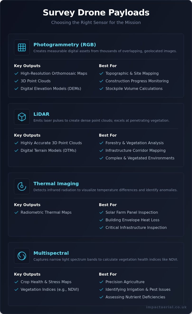
Photogrammetry (RGB) Cameras

The most widely used payload is a high-resolution RGB (Red, Green, Blue) camera for photogrammetry. This process involves capturing thousands of precisely geolocated, overlapping images. Specialised software then processes this data to create detailed and measurable digital assets.

  • Key Outputs: High-resolution orthomosaic maps, 3D point clouds, and Digital Elevation Models (DEMs).
  • Best For: Topographic mapping, visual site inspections, construction progress monitoring, and calculating stockpile volumes.

LiDAR (Light Detection and Ranging)

For projects demanding the highest level of accuracy or where ground visibility is obscured, LiDAR is the superior technology. This active sensor emits rapid laser pulses and measures the time they take to return, creating an exceptionally dense point cloud. Its primary advantage is the ability to penetrate vegetation canopies, mapping the true ground terrain beneath.

  • Key Outputs: Highly accurate 3D point clouds and Digital Terrain Models (DTMs).
  • Best For: Forestry management, detailed corridor mapping for infrastructure, and surveying complex or vegetated environments.

Thermal Imaging Sensors

Thermal sensors detect infrared radiation (heat) rather than visible light, allowing them to visualise temperature differences across a surface. This technology is invaluable for identifying anomalies invisible to the naked eye, making it a crucial tool for inspection and maintenance tasks.

  • Key Outputs: Radiometric thermal maps (thermograms).
  • Best For: Detecting faulty panels in solar farms, identifying heat loss in building envelopes, and inspecting critical infrastructure.

Multispectral Sensors

A highly specialised payload, the multispectral sensor is the cornerstone of modern precision agriculture. It captures image data from specific, narrow bands of the light spectrum. By analysing how crops reflect this light, agronomists can calculate health indices like NDVI (Normalised Difference Vegetation Index) to assess plant vitality.

  • Key Outputs: Crop health maps and vegetation indices.
  • Best For: Identifying issues with irrigation, pests, or nutrient deficiencies to enable targeted interventions by farmers.

From Flight to Final Report: The Drone Survey Workflow

A common misconception is that a drone survey is simply about flying a drone and taking pictures. In reality, the on-site flight is just one component of a meticulous, multi-stage professional service. The true value of using a survey drone is unlocked through rigorous planning, expert data acquisition, and sophisticated post-flight processing. This end-to-end workflow transforms raw aerial data into actionable business intelligence.

Step 1: Mission Planning and Risk Assessment

Every successful survey begins long before the drone’s propellers start spinning. This foundational stage involves defining clear project objectives and the required data outputs, whether it’s a 3D model for construction progress or a high-resolution map for land management. We conduct comprehensive airspace checks and pre-flight risk assessments (RAMS) to ensure full compliance with Civil Aviation Authority (CAA) rules and site-specific safety requirements. Adherence to official guidelines, like those detailed in Federal Aviation Administration (FAA) regulations, is a cornerstone of professional operations. Automated flight paths are then planned to guarantee optimal image overlap and consistent data capture across the entire target area. For projects demanding the highest levels of accuracy, we establish and measure Ground Control Points (GCPs) to ensure survey-grade precision.

Step 2: On-Site Data Acquisition

With a robust plan in place, a CAA GVC Certified pilot executes the flight. This is far from a passive exercise; the operator actively monitors the drone’s systems, flight path, and the quality of data being collected in real-time. Strict safety protocols are followed throughout the entire operation, securing the site and managing any potential hazards. Before leaving the location, a crucial verification check is performed on the captured data. This step confirms that the imagery is sharp, comprehensive, and free from issues like motion blur or gaps, preventing the need for costly and time-consuming re-flights.

Step 3: Data Processing and Analysis

This is where raw data becomes a powerful asset. The hundreds or thousands of high-resolution images, often amounting to terabytes of data, are uploaded to specialised photogrammetry software. Through complex algorithms, this data is stitched together and processed to generate precise, usable outputs. These deliverables can include:

  • High-resolution orthomosaic maps
  • Accurate 3D point clouds and digital models
  • Digital Surface Models (DSMs) and Elevation Models (DEMs)
  • Detailed thermal inspection reports

This intensive processing stage demands powerful computing hardware and, most importantly, the technical expertise to interpret the results and create a final report that delivers clear, actionable insights for your business. Our experts handle the entire workflow, ensuring you receive top-quality, decision-ready intelligence. Learn about our survey services.

Key Industries Transformed by Survey Drones

The theoretical potential of drone technology is now a practical reality, delivering significant operational and financial advantages across key UK industries. By capturing high-resolution data from unique aerial perspectives, drones solve longstanding challenges related to safety, efficiency, and accuracy. This technology provides actionable insights that were previously too costly or dangerous to obtain, transforming workflows and improving project outcomes.

Construction and Engineering

On a modern construction site, a survey drone is an indispensable tool for project management. It provides a complete, top-down view that empowers site managers to make informed decisions, mitigate risks, and keep projects on schedule and within budget. Key applications include:

  • Progress Tracking: Regular topographic surveys create a visual timeline, documenting progress and identifying potential delays.
  • Volume Calculations: Accurately measure stockpile volumes and calculate cut-and-fill requirements, optimising resource management.
  • As-Built Verification: Compare site conditions against BIM (Building Information Modelling) designs to ensure compliance and quality control.
  • Enhanced Safety: Inspect scaffolding, structures, and other hard-to-reach areas without putting personnel at risk.

Property and Facilities Management

For managers of large commercial properties, estates, or building portfolios, drones offer a revolutionary approach to inspection and marketing. They reduce the need for expensive equipment like scaffolding or cherry pickers while delivering superior data. This leads to safer, faster, and more cost-effective management of assets. From conducting detailed roof and building envelope inspections to generating stunning 3D models for development planning, the applications are extensive. High-resolution aerial imagery also provides a powerful tool for marketing materials, showcasing properties from a compelling perspective.

Renewable Energy (Solar Farms)

Maximising efficiency is paramount in the renewable energy sector. For solar farms, a single defective panel can impact the output of an entire string. Using a survey drone equipped with a thermal camera, operators can inspect hundreds of acres in a single day-a task that would take a ground crew weeks to complete. This rapid inspection identifies faulty panels, cell defects, or soiling, allowing for targeted maintenance that restores optimal energy production and supports warranty claims with clear, evidential reports.

These examples represent just a fraction of the sectors benefiting from professional aerial data-gathering. The versatility of this technology ensures it can be adapted to meet the unique challenges of your project. To discover how our CAA GVC certified drone services can provide the critical data your business needs, get in touch with the Impact Aerial team for a consultation.

In-House Program vs. Hiring a Professional Drone Service

Once a business recognises the value of aerial data, a critical decision follows: should you build an in-house drone program or partner with a professional service? While purchasing a survey drone may seem like a straightforward investment, the sticker price is merely the tip of the iceberg. The total cost of ownership, regulatory compliance, and required expertise present a far more complex picture.

The Reality of an In-House Drone Program

Establishing an internal drone surveying capability is a significant undertaking that extends far beyond the initial hardware purchase. The true commitment involves substantial and recurring costs, along with significant operational responsibilities. Businesses must be prepared for:

  • High Initial Investment: A professional-grade drone with RTK/PPK capabilities, high-resolution sensors, specialist photogrammetry software, and powerful processing computers can easily exceed an initial outlay of £20,000.
  • Significant Ongoing Costs: This includes commercial liability insurance, annual software subscriptions, regular maintenance, battery replacement, and potential repairs.
  • Complex Training and Certification: Pilots require intensive training to pass the CAA’s General Visual Line of Sight Certificate (GVC) to operate legally for commercial purposes. This represents a major investment in time and resources.
  • The Burden of Compliance: The legal responsibility for all operations falls on your business. This includes conducting detailed risk assessments for every flight, maintaining meticulous flight logs, and staying current with evolving CAA regulations.

The Benefits of a Professional Drone Partner

Engaging a dedicated drone service provider transforms aerial surveying from a major operational challenge into a simple, on-demand resource. This approach offers a more efficient, low-risk, and expert-led solution, allowing you to focus on your core business. Key advantages include:

  • Access to Leading Technology: A professional partner invests continuously in the latest survey drone technology, sensors, and software, ensuring you receive the highest quality data without any capital expenditure.
  • Guaranteed Compliance and Safety: A certified operator handles all regulatory aspects, from flight planning and risk assessments to full compliance with CAA rules. For added peace of mind, operations are backed by comprehensive commercial insurance.
  • Leverage Deep Expertise: You gain access to experienced pilots and data specialists who understand not just how to fly, but how to capture and process survey-grade data for maximum accuracy and value.
  • Cost-Effective and Scalable: You pay only for the data you need, when you need it. This eliminates the costs of idle equipment, pilot salaries, and ongoing subscriptions, making it a financially predictable and scalable solution.

Ultimately, for businesses that require precise, compliant, and actionable data without the significant overheads, partnering with a certified professional service like Impact Aerial is the most strategically sound decision.

Transforming Your Projects with Professional Drone Surveys

It is clear that the modern survey drone is far more than a simple flying camera; it is a powerful, purpose-built tool for high-precision data acquisition. From the advanced sensors it carries to the streamlined digital workflow it enables, this technology is fundamentally changing how professionals in construction, property, and solar operate. By providing faster, safer, and more cost-effective data, drone surveys unlock new levels of insight and efficiency. The key decision for any organisation is not whether to adopt this technology, but how to implement it: by building an in-house program or by leveraging the expertise of a specialist partner.

Choosing a professional service like Impact Aerial provides immediate access to industry-leading expertise and technology, without the significant investment in equipment, training, and regulatory compliance. Our operations are led by fully qualified CAA GVC Certified pilots and backed by a £5 million commercial liability insurance policy for your complete peace of mind. Ready to leverage expert aerial data? Explore our CAA-certified drone survey services. We look forward to helping you elevate your next project.

Frequently Asked Questions About Survey Drones

How accurate is a survey drone?

The accuracy of a professional survey drone is exceptionally high, often achieving survey-grade results. When equipped with Real-Time Kinematic (RTK) or Post-Processed Kinematic (PPK) technology, a drone can achieve an absolute accuracy of 1-3 cm horizontally and 2-5 cm vertically. This level of precision is dependent on the quality of the equipment, the flight plan, and the use of ground control points (GCPs), making it a reliable tool for professional land surveyors.

What does a professional survey drone cost to buy?

The cost of a professional survey drone in the UK varies significantly based on its capabilities. An entry-level mapping drone may start around £3,000 – £5,000. For survey-grade accuracy, models equipped with RTK/PPK technology typically range from £8,000 to £15,000. High-end systems with advanced sensors like LiDAR can cost well over £20,000. These prices do not include essential photogrammetry software subscriptions, training, and insurance, which are additional operational costs to consider.

Do you need a licence to operate a survey drone in the UK?

Yes, to operate a drone for commercial purposes in the UK, you must hold the correct certification from the Civil Aviation Authority (CAA). The industry standard for professional survey operations is the General VLOS Certificate (GVC). This qualification demonstrates a high level of pilot competency and a thorough understanding of air law and safety procedures. Operating without the correct authorisation is illegal and invalidates any commercial liability insurance, which is why we prioritise full CAA compliance.

How long does a typical drone survey take to complete?

The on-site time for a drone survey depends on the size and complexity of the area. A small, relatively flat site of 1-5 hectares might only take 1-2 hours to capture. A larger or more complex site of over 50 hectares could require a full day of flight operations. This does not include the essential pre-flight planning and risk assessments, nor the post-flight data processing time, which can take several additional hours or even days to complete.

What data and reports do I receive after a drone survey?

Following a drone survey, clients receive a comprehensive suite of data tailored to their project needs. Standard deliverables include a high-resolution orthomosaic map (a georeferenced aerial image), a 3D point cloud, and a Digital Surface Model (DSM). We can also generate Digital Terrain Models (DTMs), contour maps for topographical analysis, and conduct volumetric calculations for stockpile measurements. All data is provided in industry-standard formats compatible with CAD and GIS software.

Can survey drones fly in bad weather like rain or high wind?

Safety and data quality are our primary concerns, so we do not operate survey drones in rain or other precipitation. Moisture can damage sensitive electronics and distort sensor readings. Operations are also limited by wind speed; most commercial drones have a maximum wind resistance of around 22-28 mph. We conduct detailed weather checks as part of our pre-flight risk assessment and will always reschedule a flight if conditions are deemed unsafe or unsuitable for high-quality data gathering.

