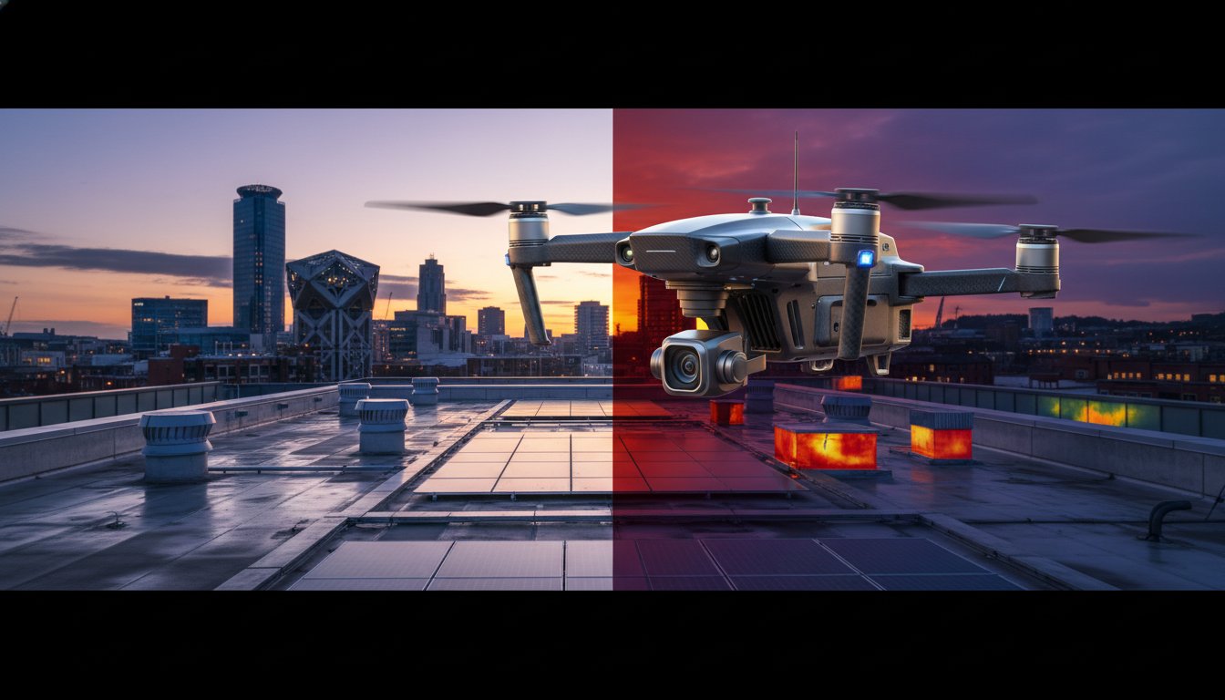
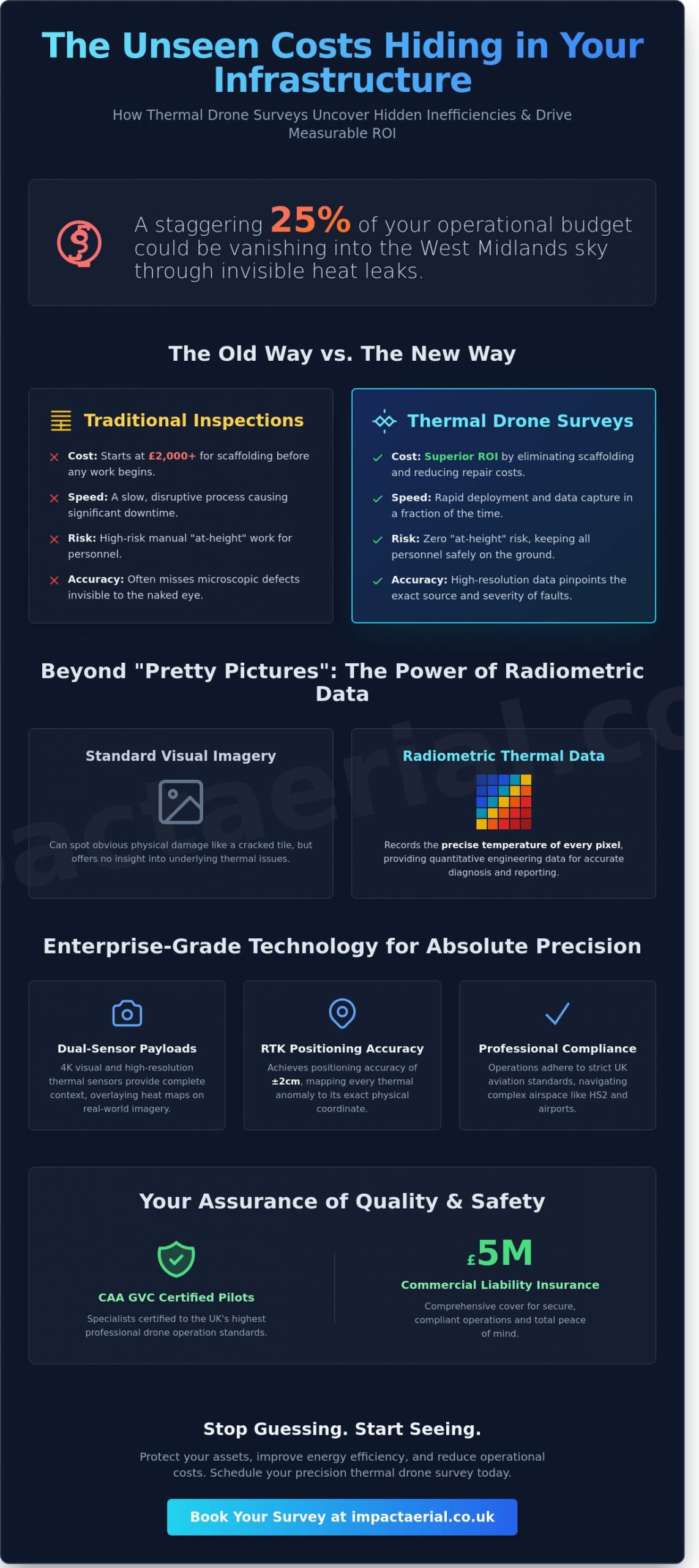
How much of your operational budget is vanishing into the West Midlands sky through invisible heat leaks? For many facility managers, the answer is a staggering 25% of their total energy spend. Investing in a professional thermal drone survey Birmingham represents a shift from reactive repairs to predictive maintenance. You’re likely already aware that traditional scaffolding for roof inspections can cost upwards of £2,000 before a single tile is even checked. It’s a slow, expensive, and high-risk approach to asset management that often misses the microscopic defects causing your utility bills to skyrocket.
At Impact Aerial, we understand that protecting your commercial assets requires more than just a standard camera. You need high-resolution radiometric data that provides clear evidence for insurance claims and repair schedules. This expert guide will demonstrate how our CAA GVC certified pilots use precision aerial thermography to identify heat loss and solar farm inefficiencies with absolute accuracy. We’ll explore the technical requirements of modern surveys and how you can achieve a measurable ROI while ensuring total compliance with the latest 2024 UK aviation safety standards for added peace of mind.
Key Takeaways
- Understand the vital distinction between visual imagery and radiometric data to ensure your infrastructure inspections capture precise, actionable temperature variations.
- See how a professional thermal drone survey birmingham delivers superior ROI by eliminating the need for costly scaffolding and high-risk manual “at-height” inspections.
- Master the logistics of aerial thermography, from identifying ideal “thermal crossover” windows to navigating Birmingham’s strict HS2 and airport airspace regulations.
- Learn how dual-sensor 4K and thermal payloads provide the necessary context to pinpoint heat loss and structural anomalies with enterprise-grade accuracy.
- Gain peace of mind by partnering with CAA GVC Certified specialists who provide £5m commercial liability insurance for secure, compliant operations across the West Midlands.
Understanding Thermal Drone Surveys in the Birmingham Landscape
A thermal drone survey birmingham provides a non-invasive method for inspecting the city’s diverse built environment. Unlike standard aerial photography, which relies on visible light, aerial thermography captures the heat signatures emitted by objects. This allows our CAA GVC Certified pilots to identify anomalies invisible to the naked eye. This technology is now a cornerstone of West Midlands infrastructure management, supporting the region’s goal to become a net-zero economy by 2041.
The distinction between a visual drone inspection and a radiometric thermal survey is significant. While a visual-only drone can spot a cracked tile, a radiometric sensor records the precise temperature of every pixel in the frame. This allows for quantitative analysis, moving beyond simple heat maps to provide professional engineering data. We use Infrared thermography to transform raw thermal data into actionable insights for asset managers and surveyors across the city.
To better understand the practical application of this technology in the field, watch this video demonstrating a specialized survey:
Birmingham presents a unique challenge for thermal diagnostics. The city’s architectural profile features a complex mix of 19th-century Victorian industrial heritage and modern glass towers like 103 Colmore Row. Each material reacts differently to heat. A thermal drone survey birmingham must account for these variations to ensure accuracy, especially when inspecting high-density areas where heat “canyons” can occur between buildings.
The Science of Radiometric Thermal Imaging
For professional engineering reports, “pretty pictures” aren’t enough. We utilize high-resolution radiometric sensors that capture thousands of individual temperature points in a single flight. This data is essential for identifying the exact severity of a fault. In the context of Birmingham’s metallic structures, emissivity refers to the efficiency with which a surface emits thermal energy, a factor that must be calibrated to avoid false readings on reflective steel or aluminium cladding. Without this technical calibration, a report lacks the precision required for insurance or structural sign-off.
Key Applications for Birmingham Businesses
For businesses and organisations across Birmingham, thermal drone surveys offer invaluable insights. From identifying critical heat loss in historic buildings to pinpointing electrical faults in industrial complexes, Impact Aerial provides precise data. Our services are crucial for property managers seeking to improve energy efficiency, construction companies requiring pre-purchase assessments, and infrastructure providers monitoring the integrity of assets. We help Birmingham businesses make informed decisions, reduce operational costs, and ensure compliance with safety and environmental standards.
The Technology: Enterprise-Grade Drones and Sensors
Impact Aerial employs a fleet of advanced, enterprise-grade drone platforms to deliver high-accuracy results. These professional aircraft are a significant departure from hobbyist drones that offer basic “thermal modes.” Professional-grade hardware is essential for a thermal drone survey birmingham because it provides the stability and power required to carry heavy, dual-sensor payloads in varied UK weather conditions. Precision is the primary differentiator here. By using Real-Time Kinematic (RTK) enabled drones, we achieve positioning accuracy of ±2cm. This level of detail ensures that every thermal anomaly is mapped to its exact physical coordinate, which is vital for large-scale industrial inspections.
Operating this advanced machinery requires strict adherence to safety protocols. Every mission we conduct follows the UK Civil Aviation Authority Drone Code to ensure total compliance and public safety. Our GVC certified pilots manage the complex airspace around Birmingham’s urban and industrial centres, providing the technical expertise needed to capture clean, usable data without compromising site security. For added peace of mind, our operations are backed by comprehensive commercial liability insurance tailored for high-value asset inspections.
Sensors and Payloads: The Impact Aerial Advantage
The quality of a thermal survey depends entirely on the sensor’s resolution and sensitivity. We deploy sensors with a minimum 640 x 512 thermal resolution, which is the industry standard for commercial diagnostic work. Low-resolution sensors found on consumer drones often mask small defects, such as individual failing cells on a solar farm or minor moisture ingress in a flat roof. Our sensors operate at a 30Hz frame rate. This high refresh rate prevents motion blur, allowing us to capture crisp data even when monitoring moving assets or flying in gusty conditions.
We use dual-sensor payloads to capture 4K HDR visual imagery alongside thermal data. This approach provides essential context. A hotspot on a thermal map might look like a leak, but the 4K visual overlay might reveal it’s actually a reflective piece of debris or a glass skylight. Our advanced thermal-visual fusion technology overlays structural outlines onto the thermal feed, making it much easier for facility managers to interpret the findings. If you need technical clarity on your next project, you can view our full equipment specifications to see how we maintain these high standards.
Data Processing and Thermography Software
Gathering data is only the first step in a thermal drone survey birmingham. The real value lies in the post-production phase. We use specialist thermography software to convert thousands of raw infrared images into a single, georeferenced thermal orthomosaic. This high-resolution map allows clients to see their entire site in one view while retaining the ability to zoom in on specific components to see exact temperature readings.
Our processing workflow generates temperature-scaled PDF reports that are easy to digest. We ensure all data is compatible with existing Building Information Modelling (BIM) and property management software, such as Autodesk Revit or ArcGIS. This compatibility allows your engineering teams to import our findings directly into their maintenance schedules. We provide actionable insights, not just pictures, ensuring that your repair budgets are spent where they are needed most.
ROI: The Cost-Benefit of Aerial Thermography
Investing in a professional thermal drone survey birmingham is a strategic financial decision rather than a mere maintenance expense. The primary value lies in the “1:100 rule” of preventative maintenance. Industry data suggests that £1 spent on thermal imaging today frequently saves £100 in emergency structural repairs or energy wastage over the following 24 months. By adhering to UK Thermography Authority guidelines, we provide the high-quality data needed to identify moisture ingress, insulation gaps, or electrical hotspots before they compromise a building’s fabric. This proactive approach allows facility managers to move away from reactive “break-fix” cycles toward a more predictable, data-driven budget. Using high-resolution DJI Enterprise drones, we capture thermal data that is invisible to the naked eye, providing a level of precision that traditional walk-through inspections simply cannot match.
Scaffolding vs. Drones: A Birmingham Cost Comparison
Traditional inspections in Birmingham city centre often involve complex logistics and significant overheads. Scaffolding requires “licenses to occupy” the highway from the local council, which can take weeks to approve and cost thousands of pounds before work even begins. A drone survey bypasses these hurdles entirely. Where a manual team might take three days to inspect a complex facade, our pilots complete the task in three hours. This speed removes the need for high-risk “at-height” manual work, keeping your staff safely on the ground. Drone-based surveys also offer a significant environmental advantage, reducing the carbon footprint of a typical building inspection by approximately 90% compared to using heavy access machinery and transport for scaffolding teams.
Insurance and Compliance Benefits
For added peace of mind, our professional thermal reports serve as authoritative documentation for commercial property insurance providers. Demonstrating a proactive maintenance schedule through aerial data can lead to reduced premiums by lowering the risk profile of the asset. In the renewable sector, we use this technology to survey 50+ acres of solar panels in a single day, identifying specific faulty cells that would take weeks to find with hand-held sensors. These reports are essential to validate warranty claims against manufacturers, ensuring you receive the performance you paid for. As a CAA GVC Certified operator, we ensure every thermal drone survey birmingham meets the strict standards of the Drone Safe Register, providing you with legally robust data that stands up to scrutiny from both insurers and regulatory bodies.
Planning Your Birmingham Thermal Survey: Timing and Rules
Success in a thermal drone survey birmingham depends on meticulous preparation and an understanding of thermodynamics. We don’t just launch a drone; we synchronise our operations with specific environmental conditions to ensure every pixel of data is actionable. Accurate thermal imaging requires more than just a high-resolution sensor, it demands the right atmospheric conditions and strict adherence to UK aviation law.
The Ideal Window for Thermal Data Collection
For building heat loss surveys, the window of opportunity is narrow. We primarily operate between October and April to achieve the required 10-degree Celsius temperature delta between the building’s interior and the outside air. Without this temperature difference, thermal anomalies like missing insulation or cold bridging won’t show up clearly. We also avoid “thermal crossover,” which occurs twice daily when different materials reach the same temperature, rendering the thermal camera unable to distinguish between them. Early morning flights are preferred. This timing ensures we avoid solar loading, where the sun’s energy heats the building envelope and masks internal heat loss. Our team monitors West Midlands weather patterns using hyper-local forecasting to identify these precise windows of stability.
Navigating CAA Regulations in the West Midlands
Birmingham’s airspace is among the most complex in the UK. With the Birmingham Airport (BHX) Flight Restriction Zone (FRZ) and various Restricted Area (Temporary) zones related to HS2 construction, legal compliance is non-negotiable. Impact Aerial holds full CAA GVC certification, allowing us to operate safely in congested urban environments like the Jewellery Quarter or Colmore Row. We manage all necessary permissions, including NATS coordination and local authority notifications. For added peace of mind, every mission is backed by a comprehensive risk assessment and £10 million in commercial liability insurance. We handle the bureaucracy so you can focus on the results. We ensure every flight is conducted within the law, protecting both the public and your corporate reputation.
The process from initial contact to data delivery follows a rigorous four-stage workflow:
- Initial Consultation: We define the survey objectives and identify site-specific constraints.
- Pre-Flight Planning: Our pilots conduct digital desktop studies and secure CAA airspace clearances.
- On-Site Execution: We deploy our DJI Enterprise fleet during the optimal thermal window.
- Data Analysis: We process the raw thermograms into a detailed, professional report with clear recommendations.
Impact Aerial: Birmingham’s Leading Thermal Drone Specialists
Impact Aerial operates at the intersection of technical precision and local West Midlands insight. Our base in Birmingham allows for rapid mobilisation, often within 24 hours for urgent structural assessments or leak detection tasks. We understand the city’s unique architectural landscape, from the historic industrial units in the Jewellery Quarter to the high-rise developments surrounding Curzon Street. This regional presence means we don’t just provide raw data; we provide the local context that national providers often miss.
For added peace of mind, we carry £5 million in commercial liability insurance. This level of cover is a prerequisite for working on major infrastructure projects and provides essential protection when operating near high-value assets or busy public spaces in the city centre. Our experience with major West Midlands construction firms and property developers ensures that every thermal drone survey birmingham project is executed with a focus on safety, compliance, and technical accuracy. We’ve successfully delivered data for large-scale logistics hubs and retail parks across Solihull and the Black Country, helping stakeholders identify heat loss and structural defects before they become costly liabilities.
Certified Pilots and Enterprise Equipment
All our operations are conducted by CAA GVC certified pilots who possess the technical training required for complex urban environments. We don’t use consumer-grade hardware. Instead, we invest in the latest DJI Enterprise technology, specifically the Matrice series equipped with high-resolution radiometric sensors. These systems capture temperature differentials as small as 0.05°C, providing the granular detail necessary for electrical substation inspections or solar farm analysis. You can learn more about the regulatory standards our team maintains in our UK Drone License guide.
Tailored Reporting for Commercial Success
Raw thermal imagery is only useful if it’s actionable. We provide a complete end-to-end service, moving from meticulous flight planning to detailed post-production editing. Our reports present thermal anomalies in a clear, layered format that facility managers can use to prioritise maintenance schedules. We focus on delivering a clear return on investment by highlighting exactly where energy is being wasted or where moisture ingress is compromising a roof’s integrity. For a deeper look at our data collection methodology, see our Drone Survey pillar. Whether you’re managing a single warehouse or a diverse commercial portfolio, our thermal drone survey birmingham services provide the clarity you need for 2026 and beyond. Contact our team today to request a bespoke quote tailored to your specific site requirements.
Secure Your Infrastructure with Birmingham’s Thermography Specialists
Adopting aerial thermography is no longer a luxury; it’s a strategic necessity for high-performing asset management. By converting thermal anomalies into clear, actionable insights, you’re protecting your bottom line from the costs of undetected structural failures or energy inefficiencies. Our approach combines enterprise-grade DJI hardware with a meticulous focus on data accuracy. Choosing a professional thermal drone survey birmingham ensures your project benefits from specific West Midlands geographical expertise and strict adherence to UK aviation laws.
Impact Aerial prioritises safety and compliance above all else. For added peace of mind, every flight is managed by CAA GVC Certified Pilots and protected by £5m commercial liability insurance. We deliver the technical depth needed for complex industrial inspections while maintaining the agility required for urban environments. It’s time to replace guesswork with precision data that drives real results for your business.
Book Your Professional Birmingham Thermal Survey Today
We look forward to helping you gain a new perspective on your assets.
Frequently Asked Questions
What is the best time of year for a thermal drone survey in Birmingham?
The most effective period for a thermal drone survey in Birmingham is between November and March. Reliable thermographic data requires a temperature difference of at least 10°C between the building interior and the external environment. We typically conduct these operations at night or during the early morning hours to avoid solar loading. This ensures that the thermal signatures we capture represent genuine heat loss rather than residual heat from the sun.
How much does a thermal drone survey cost in the West Midlands?
Costs for a professional survey in the West Midlands vary based on the project’s complexity and the specific airspace restrictions involved. A standard commercial inspection depends on the number of flight hours and the level of data analysis required for the final report. Because we operate under strict CAA GVC certification and carry £5 million in commercial liability insurance, our pricing reflects the high standard of safety and technical expertise provided for every project.
Can drones detect leaks in flat roofs?
Drones are highly effective at identifying trapped moisture and leaks within flat roof systems. Water retains heat longer than dry insulation materials, which creates a distinct thermal signature after sunset. Our thermal drone survey birmingham services use high-resolution radiometric sensors to pinpoint these anomalies with sub-centimetre precision. This allows asset managers to target specific areas for repair instead of replacing an entire roof surface prematurely.
Do I need a permit for a drone survey in Birmingham city centre?
Conducting a drone survey in Birmingham city centre requires specific flight permissions and adherence to CAA regulations. As a CAA GVC certified operator, we manage all necessary risk assessments and flight notifications through the relevant authorities. While the UK Open Category limits flights near people, our professional certifications allow us to operate safely in congested urban environments. We ensure every flight complies with the latest safety standards to provide you with total peace of mind.
How accurate is the temperature data from a drone?
Modern radiometric thermal sensors provide temperature data accurate to within plus or minus 2°C or 2% of the reading. These advanced DJI Enterprise drones capture metadata for every pixel in the image, allowing for detailed post-flight analysis. We calibrate our equipment to account for atmospheric conditions and material emissivity. This level of technical precision ensures that the thermal drone survey birmingham provides actionable data for structural engineers and facility managers.
What is the difference between a visual survey and a thermal survey?
A visual survey captures high-resolution 4K imagery to identify physical defects like cracks, slips, or debris. In contrast, a thermal survey uses infrared radiation to detect temperature variations invisible to the naked eye. While a visual camera might show a perfectly intact wall, a thermal sensor reveals the hidden heat bridge or moisture ingress behind it. Combining both methods provides a comprehensive overview of a building’s structural and thermal health.
How long does it take to get the thermal report back?
Most clients receive their comprehensive thermal inspection report within 72 to 120 hours of the flight completion. This timeframe allows our technicians to process the raw radiometric data and cross-reference it with visual high-resolution imagery. We provide a detailed breakdown of all thermal anomalies, including prioritised recommendations for maintenance. If your project has an urgent deadline, we can often expedite the data-gathering and analysis process to meet your requirements.
Can thermal drones find missing insulation in commercial buildings?
Thermal drones are the industry standard for identifying missing or degraded insulation in commercial properties. By scanning the building envelope, the infrared sensor highlights cold spots where insulation is insufficient or has shifted over time. These gaps are clearly visible as distinct thermal signatures on the high-quality imagery we produce. Rectifying these issues can reduce a commercial building’s energy consumption by up to 15% annually based on typical UK energy audits.
