
Aerial Inspection for Structural Engineers: 2026 Guide

Working at height is no longer a prerequisite for rigorous structural condition appraisals. For consulting engineers and asset managers, deploying aerial inspection for structural engineers has shifted high-level visual survey work from an operational liability into a precise, repeatable discipline.

You know the traditional pain points all too well. Mobilising scaffolding or specialist MEWPs introduces substantial plant hire costs, protracted permit delays, and unavoidable safety exposure under the Work at Height Regulations 2005. Even after absorbing those logistical setbacks, physical inspections often yield incomplete visual coverage across deteriorated masonry, bridge soffits, and complex roof spans, leaving critical gaps when integrating field findings into CAD or BIM environments.

This 2026 guide demonstrates how engineering-grade drone surveys eliminate access risks while capturing millimetre-accurate visual and thermographic defect documentation. We walk through the technical specifications, compliance standards, and data deliverables, from georeferenced orthomosaics to CAD-ready 3D point clouds, required to accelerate structural assessments safely and reliably.

Key Takeaways

  • Discover how modern aerial inspection for structural engineers has evolved from qualitative visual checks into calibrated, survey-grade diagnostic assessments.
  • Understand the payload capabilities and Ground Sampling Distance (GSD) thresholds necessary to reliably identify hairline concrete cracking, spalling, and moisture ingress.
  • Evaluate the cost and safety advantages of replacing scaffolding, MEWPs, and rope access with rapid UAV deployments that eliminate working-at-height liabilities.
  • Learn how RTK-enabled photogrammetry produces georeferenced orthomosaics, dense 3D point clouds, and CAD-ready deliverables compatible with standard BIM workflows.
  • Review the essential UK procurement checklist to verify commercial drone operator compliance, CAA operational authorisations, and industrial insurance coverage.

The Evolution of Aerial Inspection for Structural Engineers

Structural engineering relies on defensible, empirical data to quantify risk and verify load-bearing integrity. Historically, high-level visual appraisals depended on manual tactile inspection or ground-based telephoto photography. Modern aerial inspection for structural engineers repositions unmanned aircraft as airborne diagnostic platforms. Within broader civil engineering and asset management frameworks, these unmanned systems serve as crucial tools in Structural Health Monitoring (SHM) strategies, capturing survey-grade diagnostic datasets rather than simple qualitative snapshots.

To see how remote sensing diagnostic tools are reshaping asset maintenance frameworks, watch this technical breakdown:

Transforming Structural Surveys Through Non-Contact Aerial Data

Strict enforcement of the UK Work at Height Regulations 2005 requires duty holders to avoid physical access at height wherever practical alternatives exist. Non-contact aerial surveys fulfill this statutory mandate directly. By eliminating early-stage reliance on rope access, fixed scaffolding, or mobile elevating work platforms (MEWPs), engineers conduct thorough appraisals without exposing personnel to edge drops or falling object hazards.

UAV platforms gather complete envelope datasets across complex elevations without requiring disruptive road closures or halting site operations. Calibrated flight paths enable engineers to capture repeatable spatial baselines. This consistency makes it straightforward to monitor progressive movement, shear crack elongation, or masonry displacement during scheduled dilapidation surveys and condition assessments.

Key Asset Classes Benefiting from UAV Structural Inspection

Deploying aerial inspection for structural engineers delivers distinct operational advantages across several challenging built environments:

  • Commercial and Historic Facades: High-resolution optical sensors resolve spalling stone, corroded wall ties, and fractured parapets without disturbing delicate heritage fabric.
  • Civil Transport Infrastructure: Rapid deployment over highway bridges, railway viaducts, and culverts documents bearing seat wear and abutment shift without costly line possessions or carriageway closures.
  • Industrial Structures: Remote thermal and visual flight profiles inspect flare stacks, telecommunications towers, processing silos, and expansive industrial roofs while facilities remain fully operational.

Structural Defect Identification: Engineering Data Captured by UAV Payloads

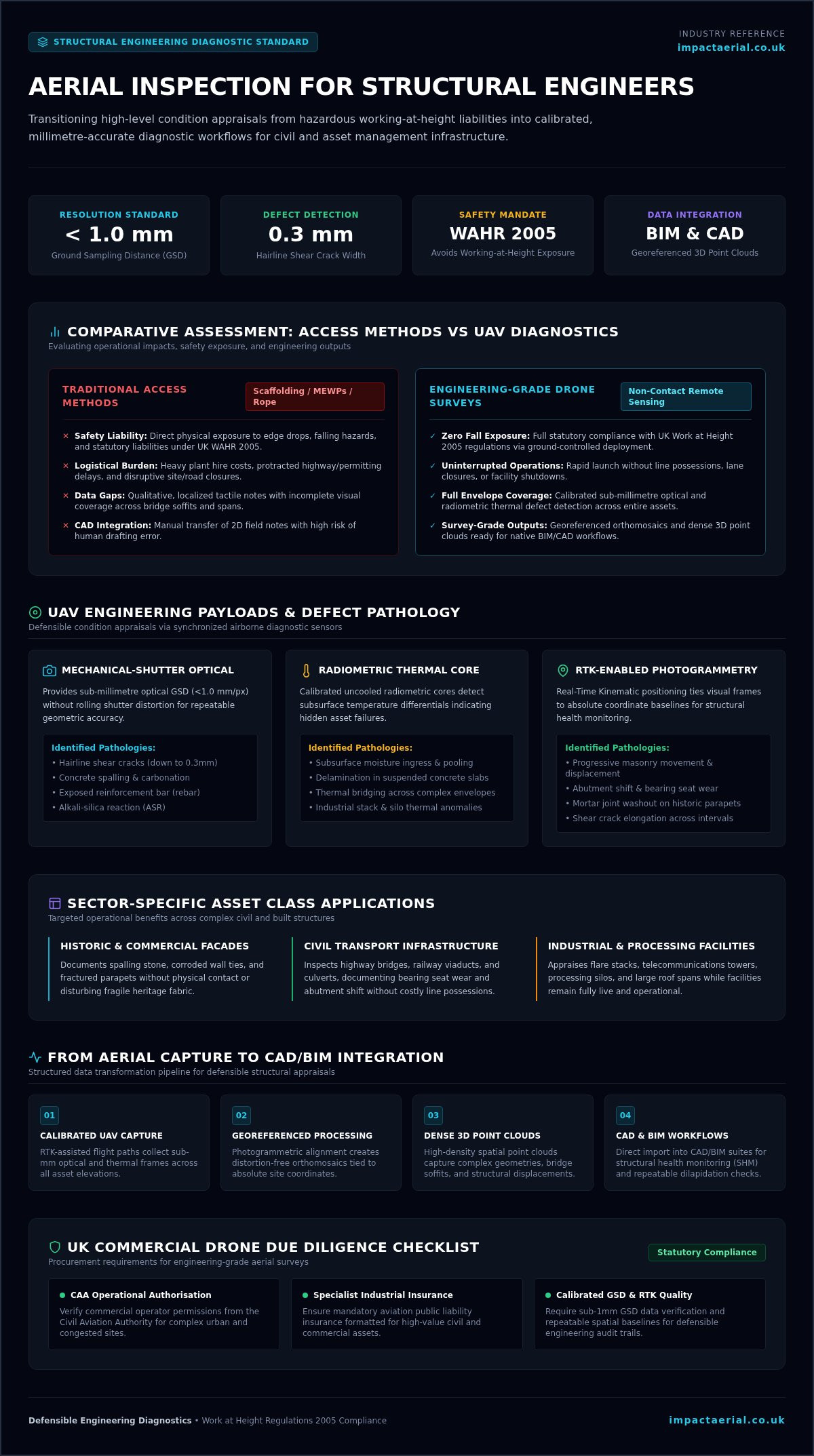
Defensible structural condition appraisals require optical precision and spatial accuracy. Commercial-grade airframes carrying mechanical-shutter visual sensors and uncooled radiometric cores turn routine flight paths into airborne diagnostic benches. Conducting an aerial inspection for structural engineers hinges on precise flight geometry that achieves a Ground Sampling Distance (GSD) below 1.0 mm per pixel. At this fidelity, engineering teams can accurately measure crack propagation, surface anomalies, and material degradation directly from raw, georeferenced visual data.

Concrete and Masonry Pathology Detection

Sub-millimetre optical resolution makes concrete defect appraisal verifiable and repeatable. High-resolution visual payloads identify early-stage alkali-silica reactions, carbonation-induced spalling, exposed reinforcement bar, and delamination across bridge decks or suspended slabs. Resolving optical clarity below the 1mm GSD threshold allows engineers to trace hairline shear cracks down to 0.3mm in width. For historic masonry, calibrated sensors document mortar joint washout, displaced stone blocks, and freeze-thaw deterioration across high-level parapets without physical contact.

Steelwork, Fastener, and Weld Integrity Verification

Inspecting structural steelwork from ground level often leaves critical blind spots on top flanges and gusset connections. UAV platforms equipped with optical zoom payloads inspect primary connections, riveted splices, and bolted nodes from safe standoff distances. Pilots capture clean line-of-sight angles to reveal paint film breakdown, severe pitting, section loss, and distorted plates. These high-resolution viewpoints allow asset teams to spot fatigue cracking across high-stress welds on crane gantries, pipe bridges, and exposed structural trusses before failures develop.

Radiometric Thermal Imaging for Moisture and Insulation Assessment

Radiometric thermal sensors measure long-wave infrared radiation, exposing subsurface anomalies that standard optical cameras miss. Operating during solar transition windows, these sensors identify trapped moisture within multi-ply flat roof membranes and locate missing insulation behind architectural rainscreens. Wet insulation retains thermal energy longer than dry substrate, creating distinct surface temperature deltas. As flight operations expand safely under evolving UK Civil Aviation Authority regulations, engineering teams regularly commission calibrated drone commercial property surveys to uncover latent moisture traps before interstitial corrosion damages concealed structural members.
Aerial Inspection for Structural Engineers: 2026 Guide

Comparative Assessment: Aerial Surveys vs Traditional Access Methods

Traditional structural access strategies carry heavy logistical baggage. Erecting system scaffolding, mobilising truck-mounted mobile elevating work platforms (MEWPs), or deploying industrial rope access teams demands extensive planning, physical permits, and considerable plant hire expenditure. In contrast, modern aerial inspection for structural engineers offers an agile alternative that delivers comprehensive visual coverage while keeping technical personnel safely at ground level.

Cost, Speed, and Operational Disruption Comparison

Scaffolding installations often require days or weeks to design, erect, and certify before an engineer can inspect a single elevation. In congested urban settings, this process requires costly pavement licences, lane closures, and pedestrian exclusion zones. Powered access equipment faces similar limits, restricted by uneven ground bearing pressures, tight turning radii, and reach constraints.

A commercial UAV platform deploys within minutes of completing on-site safety briefs. Inspections that once required days of cradle access can wrap up in hours. Validated research into drone-enabled bridge inspection methodology demonstrates that unmanned flights capture equal or superior defect inventories without halting critical operations. Plant managers avoid expensive factory shutdowns, and highways authorities keep traffic moving safely below inspected overpasses.

Mitigating Health, Safety, and Site Risk Exposure

Falls from height remain a leading cause of fatal and major injuries across UK construction and maintenance sectors. Under the Health and Safety Executive (HSE) hierarchy of control, duty holders must eliminate physical work at height whenever a safer, practical method exists. Non-contact drone surveys achieve this standard directly:

  • Eliminating Access Hazards: Surveyors examine fragile industrial roofs, deteriorated cladding, and steep embankments without stepping onto unrated surfaces.
  • Minimising Site Footprint: Replaces heavy erection teams and mechanical fitters with a streamlined two-person flight crew consisting of a certified remote pilot and a dedicated visual observer.
  • Streamlining Pre-Works Approvals: Replaces complex multi-contractor Risk Assessments and Method Statements (RAMS) with a concise, non-invasive flight safety plan.

By substituting physical access liabilities with repeatable diagnostic records, aerial inspection for structural engineers safeguards project timelines and statutory compliance simultaneously.

Integrating Drone Survey Data into Structural Engineering Workflows

High-resolution imagery delivers maximum value only when processed into spatially referenced, mathematically sound engineering deliverables. Modern aerial inspection for structural engineers bridges field capture and office analytics through calibrated photogrammetry pipelines. By matching thousands of overlapping pixel signatures across multi-angle image sets, processing engines calculate precise three-dimensional geometry. Understanding what is a survey drone reveals how dual-frequency RTK/PPK GNSS receivers and onboard positional logging lock raw aerial exposures directly to the British National Grid (OSGB36) alongside verified Ground Control Points (GCPs).

Photogrammetry, Dense Point Clouds, and 3D Reality Mesh Models

Structure-from-Motion (SfM) computation processes geotagged aerial data into millimeter-dense spatial reconstructions. Consulting our foundational guide to drone survey methodologies outlines how systematic 75% forward and 70% lateral image overlaps underpin this spatial generation. The primary outputs integrate directly into standard CAD platforms:

  • Dense Point Clouds (.LAS/.LAZ): Millions of classified spatial coordinates enable volumetric calculations, structural deflection measurements, and clash detection against proposed design interventions.
  • Textured Reality Meshes (.OBJ/.FBX): Continuous, photo-realistic polygonal surfaces let structural engineers review defects, annotate crack networks, and walk clients through existing conditions within virtual review spaces.

High-Resolution Orthomosaics for Measurable Defect Mapping

Orthorectification removes perspective distortion, lens curvature, and topographical relief displacements from aerial imagery. The resulting orthomosaics serve as dimensionally accurate, map-grade visual planes. Engineers can import these composite plans directly into AutoCAD or MicroStation, scaling as-built masonry coursing, slab boundaries, and truss nodes directly against historic construction drawings. This spatial integrity makes calculating defective cladding areas or tracing linear crack paths accurate to within millimetres.

Scan-to-BIM and Structural Analysis Integration

Direct integration into Building Information Modelling (BIM) environments closes the loop between data capture and structural remediation. Classified point clouds import into Autodesk Revit or Navisworks, allowing modellers to trace structural members, model deformations, and develop parametric as-built representations. Structural analysts extract precise geometry from these reality models to establish accurate boundary conditions for Finite Element Analysis (FEA) software. For critical assets, these baseline spatial scans establish a permanent digital twin, allowing engineers to verify ongoing stability across future inspections. To integrate survey-grade aerial models into your engineering assessments, partner with Impact Aerial for your next survey.

Procuring Professional Aerial Inspections: UK Compliance and Due Diligence

Commissioning an aerial survey involves far more than booking a camera platform. For structural consultancies, vetting drone contractors is an essential risk-management step to ensure safety, legal compliance, and reliable evidence. Specifying an aerial inspection for structural engineers requires a structured pre-qualification process. When evaluating nationwide drone services, engineering procurement leads must evaluate three core pillars: aviation licensing, site safety protocols, and commercial indemnity.

Aviation Governance, CAA GVC Certification, and Operational Authorisations

Operating near complex structures, highways, or congested urban areas places flights directly within the UK Civil Aviation Authority (CAA) “Specific” category. Structural engineers should never commission operators flying under hobbyist rules or baseline Open category limitations. Verify that remote pilots hold a valid General Visual Line of Sight Certificate (GVC) and operate under an active, CAA-granted Operational Authorisation.

Reviewing the current framework for a UK drone license ensures you understand what legal permissions an operator must maintain. Professional flight teams submit comprehensive, site-specific Risk Assessments and Method Statements (RAMS) prior to arrival. They also manage direct airspace coordination, securing permissions from local aerodromes whenever assets sit within active Flight Restriction Zones (FRZs).

Commercial Insurance and Enterprise Hardware Standards

Standard contractor insurance policies rarely cover commercial aviation activities. Major infrastructure assets, active plants, and transport networks demand clear financial protection. Procurement checklists must mandate:

  • Specialist Aviation Insurance: A minimum of £5m commercial public liability cover compliant with Regulation (EC) 785/2004, tailored specifically for industrial worksites.
  • Enterprise Airframes: Deployment of commercial-grade DJI Enterprise airframes featuring redundant IMUs, dual battery systems, RTK positioning modules, and omnidirectional obstacle sensing.
  • Secure Data Governance: Encrypted data pipelines, protected cloud storage, and clear non-disclosure protocols to protect sensitive infrastructure drawings and client building models.

Insisting on these baseline technical and regulatory thresholds protects your firm against third-party liability while ensuring the delivered survey data withstands scrutiny during statutory building control and warranty reviews.

Modernising Structural Appraisals Through Precision UAV Data

Adopting aerial inspection for structural engineers changes how consulting teams evaluate critical assets. Moving away from costly access plant and hazardous working-at-height permits lets engineering teams capture sub-millimetre defect records without site disruption. Whether mapping masonry fractures or exporting classified point clouds directly into Revit and AutoCAD, drone-driven data collection delivers reliable, measurable geometry that accelerates condition reporting.

Impact Aerial operates as a trusted technical survey partner across the UK. Equipped with commercial-grade DJI Enterprise aircraft, our CAA GVC certified commercial drone pilots maintain rigorous operational standards supported by £5m commercial liability insurance coverage for complex industrial worksites. When you’re ready to eliminate access liabilities and secure survey-grade deliverables, discuss your structural inspection project with our CAA GVC certified pilots.

Frequently Asked Questions

Can aerial drone inspections identify structural cracks smaller than one millimetre?

Yes. Optical payloads flown close to structural surfaces achieve ground sampling distances below 1mm per pixel, resolving hairline cracks down to 0.3mm. Commercial airframes with mechanical shutters eliminate motion blur, capturing high-contrast imagery where surface fissures stand out clearly against concrete, stone, or protective coatings. Engineers can measure crack widths and trace linear propagation across successive inspection intervals with high confidence.

Do structural engineers need their own drone license to commission aerial surveys?

No, structural engineers don’t need a drone license to commission aerial inspection services. When contracting professional aerial inspection for structural engineers, regulatory compliance rests with the drone operator. However, engineering leads should verify that the flight provider holds valid CAA Operational Authorisations, employs GVC-certified remote pilots, and carries adequate commercial liability insurance tailored for industrial and infrastructure sites.

How accurate are UAV photogrammetry point clouds for structural CAD modelling?

UAV photogrammetry delivers sub-centimetre spatial accuracy when integrated with dual-frequency RTK/PPK GNSS positioning and ground control points. Typical root-mean-square errors range between 10mm and 25mm horizontally and vertically on calibrated structural surveys. This dimensional fidelity allows technicians to import dense .LAS or .LAZ point clouds directly into Revit, AutoCAD, or Navisworks for clash detection, deflection measurement, and as-built modelling.

What UK CAA permissions are required for drone surveys in congested city centres?

Flying in congested urban areas requires an Operational Authorisation granted by the UK Civil Aviation Authority under the Specific category. Standard Open category flights don’t permit commercial operations near uninvolved people or densely built assets. Operators must submit a comprehensive safety case, hold GVC pilot accreditations, establish secure takeoff cordons, and coordinate with local air traffic control if operating within an aerodrome Flight Restriction Zone.

Can drones safely inspect internal structures like industrial warehouses and voids?

Yes, specialised collision-tolerant or cage-protected drones safely operate in confined interior environments and unlit industrial voids. In environments where GNSS signals can’t penetrate, these airframes rely on visual positioning systems, LiDAR sensors, and powerful onboard illumination. Structural engineers use indoor UAVs to inspect roof trusses, bridge box girders, silos, and storage tanks without erecting scaffolding or risking confined-space personnel entry.

How does thermal imaging from drones assist in structural water ingress assessments?

Thermal imaging identifies subsurface moisture entrapment by detecting differences in thermal mass between wet and dry insulation. Saturated roofing materials retain heat longer than dry substrate as ambient temperatures drop during evening transition windows. Deploying radiometric thermal payloads during an aerial inspection for structural engineers highlights these temperature differentials clearly. Asset teams can pinpoint roof membrane punctures, interstitial condensation, and facade insulation voids without cutting destructive core samples.

What weather conditions prevent commercial UAV structural inspections from proceeding?

Flights are suspended during sustained precipitation, heavy fog, high-velocity winds, or sub-zero icing conditions. While enterprise airframes feature IP-rated weather sealing, rain droplets on camera lenses distort photogrammetric alignment and obscure micro-defects. High wind gusts above manufacturer thresholds can compromise flight stability near sheer vertical facades. Commercial operators monitor localised meteorological forecasts to schedule flights during stable atmospheric conditions that ensure safe flying and clear data capture.

Professional Drone Inspection for Bridges: The Complete UK Guide

Did you know that traditional access methods like scaffolding and under-bridge units can account for up to 80% of a total inspection budget? For a standard UK highway bridge, these preliminary costs often exceed £15,000 before a surveyor even begins their assessment. It’s a frustrating reality for asset managers who must balance strict maintenance schedules with tightening budgets and the inherent risks of working over water or live traffic. Professional drone inspection for bridges offers a sophisticated alternative that removes these barriers while improving data accuracy.

We understand that your primary goal is maintaining structural integrity without the logistical headache of road closures or putting personnel at risk. This guide explores how professional aerial surveys are transforming the industry by delivering high-resolution digital twins and centimetre-accurate data at a fraction of the traditional cost. You’ll discover how our CAA GVC Certified pilots use DJI Enterprise technology to provide total peace of mind through superior data gathering. We will break down the specific ROI of aerial surveys, the latest UK safety regulations, and how to achieve a zero-disruption workflow for your next inspection programme.

Key Takeaways

  • Understand how a professional drone inspection for bridges overcomes traditional challenges by eliminating traffic disruption and significantly reducing personnel risk.
  • Explore the technical capabilities of 4K HDR DJI Enterprise drones and high-zoom lenses for identifying critical structural flaws with unmatched clarity.
  • Learn why adhering to UK regulations, including CAA GVC certification and £5m commercial liability insurance, is essential for providing peace of mind during infrastructure surveys.
  • Discover the methodical process involved in aerial surveys, from rigorous pre-flight airspace checking to the delivery of actionable digital data.
  • Gain insights into how expert asset management can lead to substantial cost savings and more efficient maintenance schedules for bridge owners and local authorities.

The Evolution of Bridge Inspection: Why Drones are the New Standard

The UK’s infrastructure network includes over 70,000 bridges, many of which require biennial General Inspections and six-yearly Principal Inspections to remain compliant. Historically, these assessments relied on visual checks conducted from complex scaffolding or under-bridge units (UBUs). These methods are notoriously slow and expensive. A professional drone inspection for bridges offers a modern alternative, replacing qualitative manual notes with high-resolution, quantitative digital records that integrate directly into a Bridge Management System (BMS).

To better understand the technical workflow and data precision involved in this transition, watch this helpful video demonstrating structural survey techniques:

UAV technology effectively tackles the “Big Three” obstacles of infrastructure management: safety, speed, and data quality. By deploying 4K, High Dynamic Range (HDR) DJI Enterprise drones, we capture centimetre-level detail without requiring an inspector to dangle from a harness. This transition from subjective sketches to measurable photogrammetry data allows for precise tracking of crack propagation and spalling over time. It’s a move from reactive guesswork to data-driven structural health monitoring.

The Economic Case for Aerial Surveys

Hiring a UBU often costs between £600 and £1,500 per day; this doesn’t include the massive expense of traffic management and lane closures on major routes like the M6 or M25. Aerial surveys eliminate these indirect costs. Our professional services can reduce inspection timelines by up to 70% compared to traditional access methods. This efficiency provides long-term ROI by enabling predictive maintenance. Identifying a minor defect today through a drone inspection for bridges prevents a £500,000 structural repair a decade from now.

Improving Safety in High-Risk Environments

Safety is our primary metric. Structural engineers face significant “working at height” risks during traditional inspections. Drones remove the human element from the danger zone. Whether we’re operating over the River Severn, live rail lines, or busy motorways, the inspector remains safely on the ground. As a CAA GVC Certified operator, we ensure every flight adheres to strict UK safety regulations. This approach minimises the time personnel spend in live traffic environments, significantly lowering the probability of site accidents and providing total peace of mind for site managers.

Technical Capabilities: Sensors, Data, and High-Resolution Clarity

Precision is the baseline for any structural survey. Our fleet utilises 4K HDR DJI Enterprise drones, such as the Matrice 350 RTK, to deliver unmatched visual clarity. These platforms carry 45-megapixel full-frame sensors that capture data with surgical accuracy. High-zoom lenses, often featuring 23x optical zoom, allow our pilots to identify hairline cracks as small as 0.2mm from a safe standoff distance of 10 metres. This capability removes the need for expensive under-bridge units or temporary scaffolding. We also employ thermal imaging to detect subsurface delamination. By identifying temperature differentials, we can pinpoint moisture ingress or internal voids before they cause structural failure. Operating within the latest UK Civil Aviation Authority (CAA) regulations ensures these complex flights remain safe and fully compliant.

Choosing between photogrammetry and LiDAR depends on the specific bridge geometry. LiDAR is essential for bridges with heavy vegetation or complex lattice steelwork, as it penetrates gaps to create a precise structural skeleton. Photogrammetry excels at providing high-texture visual overlays for concrete surfaces. A modern drone inspection for bridges often combines both to create a comprehensive data set that traditional methods simply can’t match.

Visual Inspection and Crack Detection

We prioritise achieving a sub-millimetre Ground Sample Distance (GSD) for every project. This level of detail allows engineers to perform structural analysis from their desks with 100% confidence. Our drones capture difficult angles, including piers, bearings, and underside soffits, which are often overlooked during manual walk-arounds. By standardising this visual data, we provide a consistent baseline for year-on-year condition monitoring, making it easy to track crack propagation over time. For added peace of mind, you can explore our specialist aerial services to see how we apply this technology.

Advanced Data Outputs: 3D Models and Digital Twins

The transition from raw images to actionable intelligence happens through advanced processing. We create accurate 3D point clouds that allow for millimetre-accurate structural measurements without touching the bridge. These digital twins serve as a permanent record for long-term asset management. We specialise in integrating this drone data into existing Building Information Modelling (BIM) workflows. This ensures that a drone inspection for bridges isn’t just a one-off report, but a dynamic tool that informs maintenance schedules and budget allocations for years to come.

Safety and Compliance: Navigating UK Regulations and Risk

Safety isn’t a box-ticking exercise when conducting a drone inspection for bridges. It’s the foundation of every flight. Working near live traffic, active rail lines, or open water requires more than just piloting skills; it demands a deep understanding of the Civil Aviation Authority (CAA) framework. Impact Aerial operates within this niche but increasingly diverse market by prioritising stringent safety protocols over everything else. We understand that infrastructure managers need more than just photos; they need the assurance that every risk has been quantified and mitigated.

Modern methods have evolved significantly, as evidenced by academic research on bridge inspection technology from the University of Bristol, which highlights the shift toward digital and remote data gathering. To support this professional approach, every project we undertake is backed by £5 million in commercial liability insurance. This isn’t an optional extra. It’s the baseline requirement for UK infrastructure assets managed by local councils or National Highways. For added peace of mind, our insurance is specifically tailored for commercial drone operations, covering both physical damage and data privacy concerns.

Understanding CAA Regulations for Infrastructure

The transition from the old PfCO to the GVC (General Visual Line of Sight Certificate) in December 2020 marked a professional shift in the industry. For our clients, this means our pilots have passed rigorous theory and practical assessments specifically designed for complex environments. We operate under specific Operational Authorisations that allow us to fly in congested urban centres or near property where standard “open category” rules don’t apply. This legal framework ensures that your drone inspection for bridges is fully compliant, avoiding the legal risks associated with uncertified operators.

Risk Mitigation and Method Statements

We don’t arrive on-site and hope for the best. Every project begins with a detailed Risk Assessment and Method Statement (RAMS). We coordinate with stakeholders like Network Rail, the Environment Agency, or local police to ensure everyone’s informed. Our drones feature failsafe technology, including Return-to-Home (RTH) functions and obstacle avoidance sensors that detect objects within a 360-degree radius. We follow a strict protocol for every deployment:

  • Site-specific surveys: Identifying overhead power lines, bird nesting sites, or SSSIs before the drone leaves the ground.
  • Communication: Establishing direct links with local Air Traffic Control (ATC) if the bridge sits within a Flight Restriction Zone (FRZ).
  • Emergency Protocols: Clearly defined “kill switches” and landing zones to manage unexpected hardware issues or airspace incursions.

This meticulous planning is why we’re trusted with sensitive sites and busy transport hubs. We manage the complexity so you can focus on the data.

The Inspection Process: From Pre-Flight Planning to Digital Delivery

A professional drone inspection for bridges follows a rigorous, multi-stage workflow designed to ensure safety and data integrity. We begin with a detailed consultation to define the specific engineering goals, whether that involves identifying hairline fractures in concrete or assessing corrosion on steel girders. This phase establishes the required GSD (Ground Sample Distance) to ensure the final imagery provides the sub-millimetre detail necessary for structural sign-off.

Pre-Flight Preparation and Logistics

Before any rotors spin, our team conducts a comprehensive desktop survey. We check UK airspace via NATS and SkyWise to identify permanent or temporary flight restrictions. We manage all logistics, from securing permissions from bodies like National Highways or the Canal & River Trust to notifying local authorities. Safety is our priority; we identify site-specific hazards such as 400kV power lines, nesting birds, or high-velocity wind tunnels created by valley topography. We monitor weather patterns 48 hours in advance, ensuring wind speeds remain below the 15m/s limit for our heavy-lift enterprise fleet.

Execution and Data Capture

On-site execution utilises commercial-grade DJI Enterprise hardware, typically the Matrice 350 RTK. This platform provides the stability and redundancy required for working near high-value infrastructure. Our pilots follow systematic, pre-programmed flight paths to achieve 100% structural coverage, including difficult-to-reach bearings and soffits. We often provide a real-time 4K downlink, allowing bridge engineers to remain safely on the ground while directing the pilot to specific areas of concern. Every image is georeferenced using RTK (Real-Time Kinematic) positioning, providing 1-3cm horizontal and vertical accuracy for every pixel captured.

Analysis and Post-Production

The raw data, often exceeding 2,500 high-resolution images, undergoes meticulous processing. We organise these files into a coherent, navigable digital report that allows engineers to “fly” around a 3D twin of the bridge from their office. We highlight critical defects like spalling or water ingress for urgent attention. This data often feeds into larger professional drone surveys that map the surrounding topography and approach roads. For added peace of mind, all our data handling complies with GDPR and is delivered via secure, encrypted cloud platforms.

Secure your infrastructure assets with precision data.
Contact Impact Aerial today for a technical consultation on your next bridge inspection project.

Why Impact Aerial is the Trusted Partner for Bridge Inspections

Impact Aerial brings a wealth of experience to the specialised field of drone inspection for bridges. While our headquarters are in Birmingham, our operational reach extends across the entire UK, servicing critical infrastructure from the West Midlands to the Scottish Highlands. We’ve spent the last 8 years refining a workflow that combines cinematic visual quality with rigorous technical data collection. This dual capability means we don’t just provide standard photos; we deliver high-fidelity datasets that engineers rely on for structural integrity assessments.

Our team uses the latest 4K HDR DJI Enterprise technology, including the Matrice 350 RTK series equipped with high-zoom and thermal sensors. This hardware allows us to identify defects, such as hairline cracks or moisture ingress, that are often invisible to the naked eye. We apply meticulous attention to detail during the post-production phase. Our analysts categorise every image and data point into actionable reports that highlight priority maintenance areas. In 2023, we completed over 45 complex structural surveys, providing clients with a 95% reduction in inspection time compared to traditional rope access or scaffolding methods.

A Client-Centric Approach

We understand that infrastructure projects involve high stakes. We focus on providing “peace of mind” through transparent communication and a £10 million commercial liability insurance policy. Every deliverable is tailored to meet specific engineering requirements. This ensures the data integrates seamlessly into your existing BIM or CAD workflows. Our commitment to safety and professional excellence is underpinned by our status as a CAA GVC certified operator, confirming we meet the highest standards of flight safety and regulatory compliance in the UK.

Beyond Inspection: Full Project Lifecycle Support

Our services evolve alongside your project. We support the full lifecycle, moving from initial pre-planning surveys to active construction site monitoring and final handover inspections. By integrating aerial data with virtual tour creation, we provide stakeholders with an immersive way to engage with the site. This digital twin approach has proven invaluable for public consultations and internal progress reviews, as it allows users to inspect the asset from any angle remotely. Choosing a partner for drone inspection for bridges requires a balance of technical skill and regulatory knowledge, which is exactly what we provide.

Elevate Your Structural Asset Management

Transitioning to a modern drone inspection for bridges isn’t just about adopting new technology; it’s about securing the longevity of vital UK infrastructure. By replacing traditional high-risk methods with our DJI Enterprise fleet, you’re choosing 4K HDR clarity that identifies structural fatigue long before it becomes a critical failure. This methodology removes the need for costly lane closures and dangerous rope access, providing a faster, more cost-effective data delivery system for your engineering teams.

Impact Aerial provides the technical expertise required to navigate complex UK airspace and safety requirements. Our operations are led by CAA GVC Certified Pilots and backed by £5m commercial liability insurance for your total peace of mind. We don’t just capture footage; we provide the precise, actionable data your surveyors need to make informed maintenance decisions. Whether you’re managing a single Victorian masonry arch or a multi-span motorway crossing, our team ensures every bolt and weld is documented with meticulous accuracy.

Take the next step in digitising your asset maintenance programme. Request a Professional Bridge Inspection Quote today and see how our specialist aerial services can streamline your next survey. We look forward to supporting your project’s safety and efficiency goals.

Frequently Asked Questions

How much does a drone bridge inspection cost compared to traditional methods?

A drone bridge inspection typically costs between £800 and £2,500 per day, representing a saving of 30% to 50% over traditional methods. Manual inspections often require scaffolding or under-bridge units that can cost over £1,500 per day in rental fees alone. By choosing aerial surveys, you eliminate the need for heavy plant hire and large ground crews, significantly reducing your overall project spend.

Can drones identify hairline cracks in concrete structures?

Yes, our 45-megapixel sensors can identify hairline cracks as small as 0.1mm on concrete surfaces. We use 4K HDR DJI Enterprise drones to capture high-quality visuals that allow engineers to zoom in during post-processing with incredible clarity. This level of detail ensures that even the smallest structural defects are documented for your asset management records without the need for physical contact.

Do I need to close the bridge or manage traffic during a drone survey?

You rarely need to close a bridge or implement full traffic management during a drone inspection for bridges. Because the aircraft operates from the air, traffic flow remains uninterrupted in 95% of our projects. This avoids the £2,000 average daily cost associated with temporary traffic signals and prevents public disruption. We coordinate with local authorities to ensure every flight complies with safety regulations while keeping your infrastructure operational.

What qualifications should a drone pilot have for bridge inspections in the UK?

Every professional pilot must hold a CAA GVC (General Visual Line of Sight Certificate) and carry commercial liability insurance of at least £5 million. Since the regulatory update in 2020, the GVC is the standard requirement for complex commercial operations. For added peace of mind, our team is also vetted through the Drone Safe Register. These credentials ensure that your inspection is conducted legally, safely, and to the highest professional standards.

How long does a typical drone bridge inspection take to complete?

A typical drone inspection takes between four and eight hours on-site to complete. Traditional manual surveys often require three to five days for the same scope of work because of the time needed to set up rigging or rope access systems. Our rapid deployment protocols mean we can often inspect a medium-sized motorway overpass in a single morning. This efficiency allows us to cover multiple assets within a single working week.

What happens if the bridge is in a restricted airspace or near a railway?

We manage all necessary permissions and “Non-Standard Flight” (NSF) applications if your bridge is in restricted airspace or near a railway line. When working near Network Rail assets, we follow the RIS-1530-PLT standard and coordinate directly with their Air Operations team. For other restricted zones, we submit applications to the CAA at least 21 days in advance. Our meticulous approach to regulation ensures your project stays on schedule and fully compliant.

Can drones perform inspections on the underside of bridges?

Drones can perform detailed inspections on the underside of bridges using upward-facing gimbals and specialised collision avoidance sensors. Our fleet includes aircraft that mount cameras on top of the frame to capture clear 4K imagery of soffits, bearings, and abutments. We use ultrasonic sensing to navigate safely in the confined spaces beneath a bridge deck. This provides a comprehensive view of the structure that was once only accessible via expensive cherry pickers.

What kind of data deliverables will I receive after the inspection?

You’ll receive a professional data pack containing high-resolution 4K imagery, 3D photogrammetry models, and a georeferenced orthomosaic map. This map allows you to pinpoint defects to within 2cm of their actual location on the structure. For a standard drone inspection for bridges, we deliver these processed files via a secure cloud portal within 72 hours. All data is provided in formats compatible with your existing BIM software and asset management systems.

