
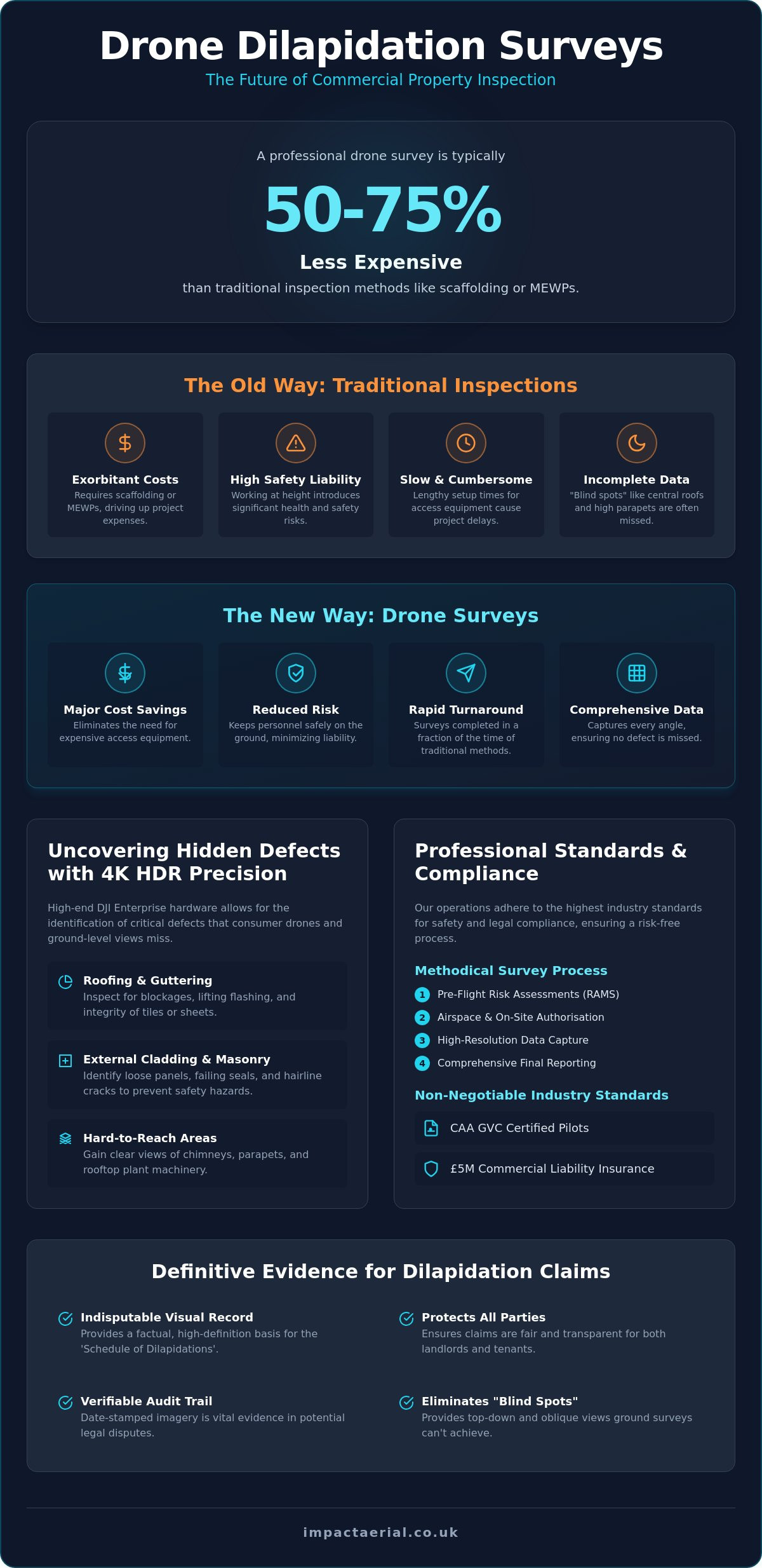
Did you know that a professional drone dilapidation survey is typically 50% to 75% less expensive than traditional ground-based inspection methods? For commercial property managers and surveyors, the old way of working often involves exorbitant costs for scaffolding or MEWPs and the constant, heavy burden of health and safety liability. It’s a slow, cumbersome process that frequently results in incomplete data, leaving critical defects hidden from ground-level views. We understand that when it’s time for a commercial property claim or a scheduled maintenance review, precision and speed are your top priorities.
In this guide, you’ll discover how aerial building inspections provide a faster, safer, and significantly more accurate alternative to traditional access. By utilizing CAA GVC certified pilots and high-end DJI Enterprise 4K HDR hardware, we ensure every inch of the building envelope is documented with meticulous detail. We’ll walk you through the technical advantages of high-resolution photographic evidence, the latest UK regulatory requirements for 2026, and how this data-centric approach drastically reduces your operational risk while delivering comprehensive reports in a fraction of the time.
Key Takeaways
- Learn how a professional drone dilapidation survey provides a definitive visual record for a ‘Schedule of Dilapidations’, protecting both landlords and tenants during property claims.
- Understand why transitioning from scaffolding and MEWPs to aerial inspections significantly lowers health and safety liability while accelerating project turnaround.
- Discover the technical advantages of DJI Enterprise hardware, which allows for the identification of critical defects like hairline cracks and water ingress that consumer drones often miss.
- Explore the methodical survey process, including the importance of pre-flight risk assessments (RAMS) and airspace authorisation to ensure a compliant operation.
- Identify the non-negotiable industry standards for commercial surveys, including the requirement for CAA GVC certified pilots and £5m commercial liability insurance.
Understanding Drone Dilapidation Surveys for Commercial Property
A drone dilapidation survey is a high-resolution aerial inspection used to document a building’s condition with forensic precision. In the context of commercial real estate, these surveys play a critical role in the ‘Schedule of Dilapidations’ process. This document outlines the repairs required to return a property to its original state as defined in a lease agreement. By providing a clear, indisputable visual record, drones protect the interests of both landlords and tenants, ensuring that claims are based on factual, high-definition data rather than subjective ground-level observations.
The building envelope, particularly high-level elevations and complex roofing systems, often hides significant defects from the naked eye. Traditional surveyors might miss hairline cracks or failing seals when restricted to the ground or limited by the reach of a ladder. Integrating aerial data into Structural Health Monitoring (SHM) ensures a proactive approach to building maintenance, identifying issues before they escalate into structural failures or costly legal battles.
To better understand this concept, watch this helpful video:
Ground-based surveyors are often hindered by “blind spots” created by the building’s geometry. Parapet walls, internal valley gutters, and central roof sections are frequently invisible from the street. A drone dilapidation survey eliminates these gaps by providing a top-down view and 45-degree oblique angles, ensuring every square meter is accounted for. This level of detail is essential for accurate cost estimation in commercial property claims, as it allows for a precise measurement of the affected areas without the initial need for scaffolding.
The Legal and Technical Context of Dilapidations
Aerial imagery provides robust support for RICS-standard dilapidation reports by offering a perspective that’s otherwise impossible to obtain without expensive access equipment. Every frame captured is date-stamped and high-resolution, creating a verifiable timeline of a building’s state. This evidence is vital in legal disputes where the timing of damage is contested. By documenting ‘before and after’ states for long-term lease agreements, stakeholders maintain a reliable audit trail that minimizes friction during the terminal dilapidations phase.
Targeted Assets: What Drones Inspect Best
Drones excel at inspecting assets that are traditionally difficult or dangerous to reach. Our DJI Enterprise 4K HDR hardware captures minute details across various building components:
- Roofing systems: We inspect guttering for blockages, flashing for lifting, and the integrity of individual tiles or sheets.
- External cladding: Identifying loose panels or failing masonry at height prevents safety hazards and water ingress.
- Hard-to-reach areas: Drones provide clear views of chimneys, parapets, and rooftop plant machinery—including commercial HVAC systems maintained by Engico Air Conditioning—that ground-based inspections simply can’t see.
This comprehensive coverage ensures that no part of the building envelope remains unmonitored, providing peace of mind for property managers and owners alike.
When this detailed data is combined with the professional insight of a firm like South Surveyors, property owners can make fully informed decisions regarding structural repairs and long-term maintenance.
The Advantages: Why Aerial Surveys Outperform Traditional Methods
Traditional building inspections often rely on invasive and costly logistics. For decades, the industry standard involved erecting scaffolding, hiring Mobile Elevated Work Platforms (MEWPs), or employing specialist steeplejack services. These methods are inherently slow and require significant lead times for planning and assembly. A drone dilapidation survey bypasses these logistical hurdles entirely. While a climbing crew might take hours to inspect a single high-level section, a professional drone operator can capture the same data in minutes. This speed of deployment is a game-changer for commercial property managers who need immediate results without the weeks of preparation required for traditional plant hire.
Cost-efficiency is another primary driver for the shift toward aerial inspections. Traditional methods often involve hidden expenses, such as local authority permits for road closures or the high rental costs of heavy machinery. Industry data indicates that drone surveys are typically 50% to 75% less expensive than traditional ground-based methods for the same area. By removing the need for physical access equipment, you’re not just saving money on the survey itself; you’re also eliminating the potential for accidental damage to the building facade caused by heavy machinery or scaffold ties. If you are looking to streamline your next inspection, opting for professional drone surveying provides a high-tier output without these unnecessary overheads.
Safety and Risk Mitigation
Safety is the cornerstone of our operations. By utilizing drones, we effectively eliminate the ‘Work at Height’ (WAH) liabilities that typically plague property inspections. Keeping personnel on the ground is the most effective way to manage risk. Drones operate with a minimal footprint, meaning they don’t disturb building occupants or the public during flight. This is particularly valuable for retail or office environments where business continuity is essential. Additionally, the rapid response capabilities of drones allow for immediate post-storm damage assessments, providing clear evidence of structural integrity before it’s safe to send a human team onto a roof.
Data Depth and Accuracy
The quality of data captured from the air far exceeds what a surveyor can see through binoculars from the ground. We utilize DJI Enterprise 4K HDR hardware to provide a ‘surveyor’s eye’ view of every architectural detail. This technology allows us to capture 100% of the building surface area, including internal valleys and parapets that are otherwise invisible. Because our flight paths are consistent and repeatable, we can perform multi-year condition monitoring with extreme accuracy. This ensures that even the smallest changes in the building envelope are documented, providing a level of precision that traditional methods simply cannot match.
Technical Capabilities: Imagery, Thermal, and Data Quality
A professional drone dilapidation survey relies on hardware that far exceeds the capabilities of standard consumer models. While hobbyist drones might capture decent video, they lack the sensor size, stability, and optical zoom necessary for forensic building analysis. We utilize DJI Enterprise hardware, such as the Matrice 350 RTK paired with Zenmuse H30T sensor payloads, to achieve sub-millimetre detail. These systems provide the precision required to identify hairline cracks in masonry or minor water ingress around window seals that would remain invisible to lesser equipment.
Zoom capabilities are a cornerstone of our safety and data strategy. High-powered optical zoom allows our pilots to maintain a safe standoff distance from the building facade while still capturing ultra-close-up imagery. This eliminates the risk of flying dangerously close to complex structures or plant machinery. Complementing this, 4K HDR video provides a fluid, technical overview of the building’s condition. This cinematic yet technical footage allows surveyors to review the entire building envelope in context, ensuring that no defect is overlooked during the analysis phase.
Thermal Imaging for Dilapidation Surveys
Thermal imaging is a vital component of a comprehensive survey, allowing us to see what the human eye cannot. By detecting temperature differentials, we identify hidden moisture trapped within roofing insulation. Wet insulation retains heat longer than dry materials, appearing as distinct ‘hot spots’ on a thermal map during evening inspections. We also detect thermal bridging and significant heat loss in commercial units. By combining RGB (visual) and thermal data, we provide a ‘complete’ building health check that identifies both structural and efficiency-related defects.
Post-Production and Deliverables
The raw data captured during a flight is only the beginning of the process. We meticulously organize hundreds of high-resolution images into a structured, navigable report that aligns with your specific survey requirements. For large-scale industrial sites, we generate 3D models and orthomosaic maps. These deliverables allow stakeholders to zoom into any part of the building with high-tier clarity, providing a digital twin of the asset. This data integrates seamlessly into existing asset management software, such as CMMS or EAM platforms, to automate work order creation and streamline long-term maintenance workflows.
The Survey Process: From Pre-Flight Planning to Final Reporting
A successful drone dilapidation survey is a structured, methodical operation that begins long before the aircraft arrives on site. We start with an initial consultation to define the specific scope of the dilapidation claim or maintenance review. This stage is vital for aligning our flight plan with the requirements of RICS-qualified surveyors, ensuring that the resulting data is admissible and useful for legal or financial settlements. We don’t just capture images; we build a data acquisition strategy tailored to the building’s unique architecture and the specific needs of the property manager.
Planning and Airspace Compliance
Urban property inspections require rigorous planning and adherence to strict safety protocols. Our team conducts detailed pre-flight risk assessments and prepares comprehensive Method Statements (RAMS) for every project. This involves checking for Temporary Restricted Areas (TRAs) or proximity to controlled airspace, such as airports or heliports. We manage the logistics of securing land-owner permissions and notifying relevant stakeholders to ensure the operation is both legal and non-disruptive. Weather monitoring is equally critical; we track wind speeds and precipitation levels to ensure optimal conditions for capturing high-tier, distortion-free imagery that meets our professional standards.
On-Site Execution and Reporting
Execution on the day involves a coordinated effort between the pilot and a secondary observer. This team structure maximizes safety and allows for real-time image review. By checking the feed as we fly, we guarantee that all critical defects identified during the planning phase are captured with absolute clarity. We follow a systematic flight pattern, often using a grid or orbital path, to achieve total coverage of the building envelope without missing a single tile, seal, or masonry joint. This methodical approach ensures that the data is consistent and repeatable for future inspections.
The process concludes with data processing and quality assurance. We organize the vast amount of 4K HDR data into a navigable, professional report. These deliverables are typically provided in digital formats or hosted on cloud-based platforms, allowing property managers to share the findings instantly with legal teams or contractors. This level of transparency and speed is what sets our services apart. If you require a reliable partner for your building inspections, our drone commercial property surveys provide the high-resolution evidence you need to move forward with confidence.
Ensuring Compliance: Why Certification and Insurance are Non-Negotiable
Professionalism in aerial surveying is defined by strict adherence to the Civil Aviation Authority (CAA) framework. When commissioning a drone dilapidation survey, technical skill is only half of the requirement. Legal and financial security form the other half. Hiring an unlicensed ‘hobbyist’ pilot for professional building inspections introduces significant liabilities. These operators often lack the specific training required to manage complex flight paths near structures and, crucially, they do not possess the commercial insurance necessary to protect your assets in the event of an incident. At Impact Aerial, we maintain a meticulous approach to every operation, ensuring that our clients are protected by high-tier professional standards and comprehensive risk mitigation strategies.
The industry standard for commercial property surveys is £5m commercial liability insurance. This level of coverage is essential for working on high-value commercial units and industrial sites. It provides the reassurance and reliability that property managers require when allowing contractors onto their premises. Without this, any accidental damage to the building or third-party property could lead to protracted legal battles and unrecoverable costs. Our commitment to safety is backed by this substantial indemnity, ensuring that every project is grounded in expert-led security.
UK Drone Laws in 2026
As of January 1, 2026, the regulatory environment for drones in the UK has become significantly more structured. All new drones sold must now carry a UK class mark (UK0 to UK6), and those in the UK1, UK2, UK3, UK5, and UK6 categories are required to broadcast Remote ID. We have successfully managed the transition from older certifications to the current GVC (General Visual Line of Sight Certificate) standard. For complex urban flights, we operate under a specific Operational Authorisation (OA) from the CAA. This allows us to fly in areas where legacy drones or uncertified pilots are now legally restricted. Additionally, our pilots are trained to manage privacy and GDPR concerns with precision, ensuring that all data collection is compliant with national data protection laws.
Choosing the Right Partner
Before hiring a provider, you must verify their credentials. Ask for their CAA Operator ID and a copy of their current Operational Authorisation. You can check a pilot’s status directly through the CAA’s official registers to ensure their qualifications are current. A professional partner should also provide a detailed Method Statement and Risk Assessment (RAMS) before starting work. If you are ready to secure high-resolution, compliant data for your building maintenance, you can request a professional drone dilapidation survey quote from Impact Aerial. We provide the technical expertise and regulatory peace of mind required for high-stakes commercial property claims.
Advancing Your Property Asset Management
Transitioning to aerial inspections represents a significant shift in how commercial property is managed. By replacing expensive plant hire and high-risk manual work with a professional drone dilapidation survey, you gain immediate access to high-tier data without the logistical burdens of the past. This methodical approach provides a forensic visual record that is both RICS-admissible and technically superior to ground-based observations, ensuring your building maintenance decisions are based on absolute precision.
Reliability in this specialized sector is built on compliance and technical excellence. Choosing a partner with CAA GVC Certified Pilots and £5m Commercial Liability Insurance ensures your operations remain safe and legally sound. Our use of DJI Enterprise Grade 4K Data guarantees that every hairline crack, failing seal, and thermal anomaly is documented with meticulous clarity. This data-centric process not only reduces your health and safety liability but also provides a repeatable audit trail for long-term asset protection.
It’s time to elevate your building maintenance strategy with faster, safer, and more accurate insights. Book your professional drone dilapidation survey with Impact Aerial today to secure the comprehensive evidence your property deserves. We look forward to supporting your next project with our expert-led aerial services.
Frequently Asked Questions
Are drone dilapidation surveys legally admissible in court or disputes?
Yes, high-resolution imagery and data from a professional drone dilapidation survey are legally admissible when conducted by certified operators. Courts and RICS-qualified surveyors accept this evidence because it provide a date-stamped, objective record of a building’s condition. This technical data is essential for settling ‘Schedule of Dilapidations’ claims between landlords and tenants, as it offers indisputable proof of structural health at a specific point in time.
How much does a drone dilapidation survey cost compared to traditional methods?
Aerial surveys are significantly more cost-effective than traditional ground-based methods. By eliminating the need for scaffolding, cherry pickers, or steeplejack services, the total expense is often reduced by 50% to 75%. You save on plant hire, labor, and the logistical costs associated with road closures or site downtime. This makes drones the most efficient choice for large commercial properties where traditional access would be prohibitively expensive.
Do I need to notify my neighbours or local authorities before a drone survey?
Yes, stakeholder notification is a standard part of our professional flight planning process. While we handle the complex airspace authorizations and notifications for local authorities or airports, we recommend that property owners inform neighboring tenants of the scheduled flight. This transparency helps manage privacy expectations and ensures the operation proceeds without disruption. We manage all formal regulatory compliance and risk assessments (RAMS) to ensure a smooth, professional deployment.
Can drones perform surveys in rain or high winds?
Professional drone operations are restricted by adverse weather to ensure both safety and data quality. We don’t fly in active precipitation or winds that exceed the safety limits of our DJI Enterprise hardware, which is typically around 12 to 15 meters per second. Capturing high-tier 4K HDR imagery requires stable flight conditions. If the weather is unsuitable, we reschedule the survey to ensure the final data is sharp, forensic, and useful for your report.
What is the turnaround time for receiving the final survey report?
Final digital reports are typically delivered within 3 to 5 working days after the on-site data collection is complete. This is a vast improvement over traditional manual surveys, which can take weeks to compile. Our post-production team organizes the high-resolution imagery into a structured, navigable format. You’ll receive a cloud-based link or digital file that can be instantly shared with legal teams, contractors, or property managers for immediate action.
What happens if the drone captures footage of people or private property nearby?
We use strict data management protocols and precise flight planning to protect the privacy of those near the site. Our pilots focus the sensors specifically on the target asset to minimize incidental capture. If people or private vehicles are captured, we apply post-production blurring to ensure full GDPR compliance. Professional drone dilapidation survey operators prioritize data protection as a core part of their service, ensuring all evidence is ethically and legally gathered.
Do drones require scaffolding to be removed before they can inspect a roof?
No, drones can perform inspections while scaffolding is in place, although it’s often more efficient to fly before it’s erected. Drones are frequently chosen specifically to avoid the cost and time of scaffolding. If the structure is already present, we can still capture high-level data, but a clear building envelope allows for 100% unobstructed views. This flexibility makes drones an ideal tool for both initial assessments and final sign-offs after repairs are finished.
Can drones detect internal building defects or only external ones?
Standard aerial drones are primarily designed for external building envelope inspections, though they can identify some internal issues. By using thermal imaging sensors, we can detect moisture trapped within insulation or significant heat loss that points to internal structural failures. While we don’t typically fly standard aircraft inside occupied offices, the data we capture from the outside provides a comprehensive overview of the building’s overall structural health and water integrity.
 2 Norton Drive, Wythall, Birmingham, B47 6HH Company registration number: 11138586. VAT Number: 366 9068 55


