
Drone Stockpile Measurement: Volumetric Survey Guide

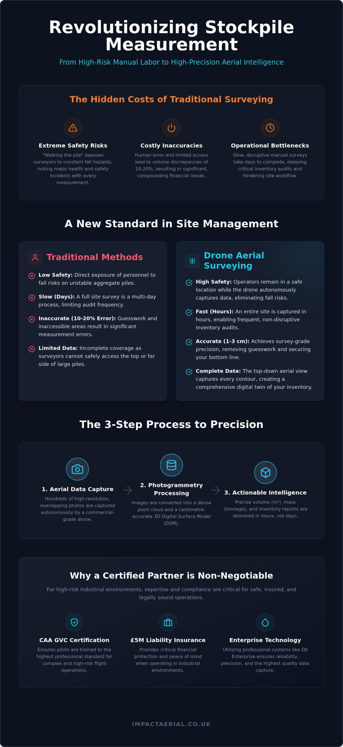
Every time a surveyor climbs a loose aggregate pile to take manual measurements, your business is one slip away from a major health and safety incident. Traditional surveying methods aren’t just hazardous; they’re also notoriously slow and prone to human error, often resulting in inventory discrepancies that lead to significant financial losses. You likely already know that relying on ground-based estimates is a bottleneck for your site’s efficiency and a risk to your staff.

Using a professional drone for stockpile measurement transforms this high-risk task into a streamlined, data-centric process. By deploying commercial-grade DJI Enterprise technology, operators can capture highly accurate 3D models of your site inventory in hours rather than days. This guide explores how CAA GVC certified pilots deliver centimetre-accurate volumetric data while ensuring your operations remain fully compliant with safety regulations. We will examine the transition from manual data capture to autonomous aerial intelligence, providing you with the technical insights needed to eliminate guesswork and secure your bottom line through precise digital twins. You’ll discover how to achieve full H&S compliance while maintaining 1 to 3cm accuracy across your entire site inventory.

Key Takeaways

  • Transition from manual “walking the pile” methods to autonomous aerial capture to eliminate fall risks and improve data consistency across your site.
  • Discover how deploying a professional drone for stockpile measurement delivers centimetre-accurate 3D models using advanced photogrammetry and Ground Sampling Distance (GSD) calculations.
  • Learn why aerial surveys reduce site time from days to hours, allowing for more frequent inventory audits without disrupting active workflows.
  • Understand the critical importance of CAA GVC certification and £5m liability insurance when selecting a technical partner for high-risk industrial environments.
  • Explore industry-specific applications, from tracking cut-and-fill balances in construction to managing high-value aggregate inventory in mining and quarrying.

What is Drone Stockpile Measurement and Volumetric Analysis?

Volumetric drone surveys represent a technical leap in how industrial sites quantify their assets. Instead of traditional ground-based methods, this process uses high-resolution aerial data to calculate the precise volume of material stockpiles. Using a drone for stockpile measurement allows site managers to move away from the hazardous practice of “walking the pile” with GPS rovers. It replaces manual estimation with autonomous, high-precision data capture.

This technology creates a high-fidelity “digital twin” of your entire site. This isn’t just a static image; it’s a geometrically accurate 3D model that serves as a single source of truth for inventory management. In sectors like aggregates and mining, centimetre-level accuracy has become the expected standard. It ensures that what’s recorded in the ledger matches what’s physically on the ground, providing psychological comfort to stakeholders through verified data.

The Evolution of Volumetric Surveying

Historically, site surveys relied on laser scanning or manual GPS points. These methods are often limited by the surveyor’s ability to safely access every part of a pile. Because ground-based surveyors can’t see the top or the far side of large mounds, traditional methods frequently lead to volume errors between 10% and 20%. These discrepancies quickly compound into significant financial losses over a fiscal year.

Modern surveys use The Science of Precision: How Photogrammetry Calculates Volume to overcome these limitations. By capturing hundreds of overlapping images from an aerial perspective, a drone for stockpile measurement can map complex, irregular shapes that ground teams simply cannot reach. This top-down view ensures every contour is accounted for, providing a level of detail that was previously impossible or too expensive to obtain regularly.

Key Metrics: Volume, Mass, and Density

Once the aerial data is captured, specialised software converts the 3D point cloud into cubic metre measurements. However, volume is only half of the equation. To provide actionable data, these cubic measurements are paired with known material density factors to calculate total tonnage. This allows for a granular understanding of site resources that manual methods can’t match.

Having access to this data in near real-time is vital for accurate financial reporting and rigorous auditing. Site managers don’t have to wait days for a report to be processed by an external agency. Precise inventory audits can be completed in hours, ensuring that month-end figures are based on verified, survey-grade data. This level of meticulousness is what separates professional aerial surveys from basic photography.

The Science of Precision: How Photogrammetry Calculates Volume

Capturing data with a drone for stockpile measurement relies on photogrammetry, the technical process of extracting 3D measurements from 2D imagery. By capturing hundreds of high-resolution photos with significant overlap, specialized software identifies common points across multiple frames. These points are then projected into a 3D coordinate system to create a dense point cloud. This cloud forms the basis of a Digital Surface Model (DSM), which provides a centimetre-accurate representation of every contour in your inventory. Academic research into Drones vs. Traditional Surveying confirms that this aerial approach is a viable, safe, and cost-effective alternative to manual methods, often achieving vertical accuracy within 20mm to 50mm.

Ground Sampling Distance (GSD) Explained

The precision of your volumetric report depends heavily on Ground Sampling Distance (GSD). GSD is the actual distance on the ground represented by a single pixel in a digital image. For example, a GSD of 1cm means each pixel in the 3D model represents exactly 1cm² of the physical stockpile. Lower GSD values lead to higher volumetric precision because the software has more detail to work with when defining the pile’s boundaries.

Several factors dictate the GSD of a survey:

  • Flight Altitude: Flying lower increases detail but requires more images to cover the site.
  • Camera Sensor: High-performance sensors, like the 4/3 CMOS found on the DJI Mavic 3E, allow for superior data capture even at higher altitudes.
  • Lens Quality: Professional-grade optics reduce distortion, ensuring that the spatial data remains consistent across the entire site.

RTK vs. Non-RTK Drone Surveys

When deploying a drone for stockpile measurement, the choice between RTK (Real-Time Kinematic) and non-RTK hardware is critical for your data’s integrity. RTK drones communicate with a base station or a satellite network to provide centimetre-accurate positioning data in real-time. This technology is vital for establishing absolute accuracy, ensuring your site’s data aligns perfectly with global coordinates and previous surveys.

Using RTK significantly reduces the need for Ground Control Points (GCPs). In a non-RTK survey, staff must manually place and measure multiple physical markers across the site to “pin” the drone data to the ground. RTK hardware streamlines this process, reducing site time and improving safety by keeping personnel away from active machinery. If you’re looking to integrate this level of precision into your workflow, our team at Impact Aerial can provide the technical consultancy needed to get started.
Drone Stockpile Measurement: Volumetric Survey Guide

Drones vs. Traditional Surveying: Speed, Safety, and ROI

Traditional topographic surveys are often a significant drain on site resources. For a large-scale industrial operation, a ground team might spend several days traversing hazardous terrain to capture enough data points for a volume estimate. In contrast, using a drone for stockpile measurement allows the same area to be mapped in just a few hours. This drastic reduction in site time translates directly into lower labour costs and, more importantly, minimal disruption to your daily operations. You don’t have to halt plant movements or clear the area for days on end; the drone operates above the workflow, capturing data while your site remains productive.

The return on investment extends beyond immediate time savings. Because aerial surveys are so efficient, site managers can move from infrequent quarterly audits to weekly or even daily inventory updates. This high-frequency data prevents over-ordering and ensures that financial reporting is always based on current site conditions rather than outdated estimates. When you consider the cost of inventory discrepancies, the ability to maintain a precise, real-time ledger provides a clear financial advantage that traditional methods simply cannot match.

The Safety Advantage: Mitigating Site Risks

The most compelling argument for aerial surveys is the immediate improvement in health and safety compliance. Traditional methods require surveyors to physically climb unstable stockpiles of sand, gravel, or coal. This presents a high risk of slips and falls, especially in the unpredictable UK weather. By deploying a drone for stockpile measurement, you remove personnel from these dangerous locations entirely. This approach supports a “Zero Harm” site culture by keeping staff away from active heavy machinery zones and precarious heights. Our CAA GVC certified pilots operate from safe stand-off distances, backed by £5m commercial liability insurance, ensuring that data collection never compromises your site safety protocols.

Data Consistency and Transparency

Manual measurements often suffer from subjective “eye-balling” or inconsistent point density, which leads to human error in volume calculations. Drones eliminate this variability by capturing millions of data points across the entire surface of the pile. This creates a permanent, high-resolution visual record that serves as a robust audit trail. If a dispute arises with a supplier or contractor, you have a time-stamped 3D model to verify the exact inventory levels at that moment. These models can be easily shared across departments via cloud-based platforms, ensuring that procurement, finance, and site operations are all working from the same verified dataset.

Industry Applications for Aerial Volumetric Surveys

The utility of a drone for stockpile measurement extends across diverse industrial sectors where material volume directly impacts the balance sheet. While the core technology remains consistent, the specific applications vary to meet the unique operational requirements of different environments. From managing high-value mineral assets to monitoring site progress, aerial data provides a level of granular detail that traditional ground-based methods cannot replicate. This transition to digital inventory management ensures that managers have access to a single, verified source of truth for their site resources.

Construction and Infrastructure Management

In the construction sector, maintaining an accurate record of earthworks is essential for financial transparency and project timelines. Site managers use comprehensive drone survey data to verify subcontractor invoices by calculating the exact volume of material moved or imported. This objective data eliminates disputes and ensures that payments are based on physical reality rather than estimates.

Sequential 3D mapping allows teams to monitor site progress over time, comparing the current state of the terrain against the original design. This volumetric data can be directly linked to Building Information Modelling (BIM) workflows, providing a seamless integration between the physical site and the digital project plan. It allows for precise tracking of cut-and-fill balances, ensuring that material is moved efficiently across the site to minimize haulage costs.

Quarrying and Bulk Material Handling

For quarrying and mining operations, material is the primary asset. Using a drone for stockpile measurement is now a standard requirement for year-end inventory audits. These surveys provide the meticulous accuracy needed for financial compliance, ensuring that “dead” stock at the bottom of a pile is distinguished from active inventory turnover. This level of detail is critical for accurate asset valuation and tax reporting.

The data also serves a vital logistical purpose. By understanding the exact volume of available aggregate, site managers can optimize their haulage and logistics schedules. This prevents bottlenecks in production and ensures that customer orders are fulfilled from the most accessible stockpiles. Real-time volume data allows for better planning of extraction rates and storage capacity, maximizing the overall efficiency of the quarry.

Other sectors also benefit from this aerial intelligence:

  • Waste Management: Monitoring landfill capacity and quantifying processed recycling material to ensure regulatory compliance.
  • Agriculture: Measuring bulk fertilizer storage and grain silos to manage seasonal supply chains more effectively.

If you need to improve the accuracy of your inventory audits or site monitoring, contact Impact Aerial to discuss our professional drone data services.

Why Hire a CAA GVC Certified Partner for Your Site?

While many businesses consider purchasing hardware for in-house use, the true value of a drone for stockpile measurement lies in the expertise of the operator and the rigour of their safety protocols. For commercial operations in the UK, holding a valid drone license is a strict legal requirement. This isn’t just a bureaucratic hurdle; it’s a verification of technical competence. Hiring a certified partner ensures your site remains compliant with Civil Aviation Authority (CAA) regulations, shielding your business from the legal and financial repercussions of unauthorised flights.

Professional operators provide a level of risk mitigation that DIY solutions cannot match. Impact Aerial carries £5m in commercial liability insurance, specifically tailored for high-risk industrial environments. This provides psychological comfort and tangible security for site managers. It ensures your company’s interests are fully protected. Every flight is conducted under strict CAA safety protocols, including detailed pre-flight risk assessments and site-specific safety briefings.

The Importance of GVC Certification

The General Visual Line of Sight Certificate (GVC) represents the industry standard for professional drone operations. It ensures safety and precision. Pilots are trained to manage complex airspace and navigate site-specific restrictions, such as proximity to power lines or active machinery. This meticulousness extends to data privacy. Professional partners are well-versed in GDPR compliance, ensuring any aerial data collection respects the privacy of site staff and neighbouring properties. By choosing a GVC-certified specialist, you’re prioritising reliability over the unpredictable results of amateur flight.

Beyond the Flight: Expert Data Processing

The value of using a drone for stockpile measurement is only realised through high-end data processing. Professional teams use specialised photogrammetry software to turn raw imagery into actionable business intelligence. Instead of just a folder of photos, you receive comprehensive PDF reports and CSV exports. These files can be directly integrated into your existing CAD or GIS software. This ensures the volumetric data is immediately useful for your finance or engineering departments.

If you’re ready to secure your site inventory with survey-grade accuracy, Contact Impact Aerial for a professional stockpile survey quote today.

Securing Your Site Inventory with Aerial Intelligence

Adopting professional drone technology is a strategic necessity for modern industrial sites. By transitioning from manual estimations to high-precision digital twins, you eliminate the safety risks associated with “walking the pile” while gaining centimetre-accurate data for your financial reporting. Using a professional drone for stockpile measurement ensures that your inventory audits are based on verified, survey-grade results rather than subjective guesswork. This methodical approach protects your staff and secures your bottom line through precise asset valuation.

Impact Aerial provides the technical expertise and regulatory compliance required for high-risk environments. Our CAA GVC Certified Pilots deliver centimetre-accurate RTK data, backed by £5m commercial liability insurance for your reassurance. Whether you’re managing construction earthworks or aggregate inventory, we provide the actionable intelligence you need to optimise your operations. Request a Professional Drone Survey Quote from Impact Aerial today and take the first step toward a safer, more efficient site. We’re ready to help you transform your data collection processes.

Frequently Asked Questions

How accurate are drone stockpile measurements compared to traditional methods?

A professional drone for stockpile measurement typically achieves accuracy within 1cm to 3cm. Traditional GPS rover methods often result in 10% to 20% volume discrepancies due to limited access and human estimation. In contrast, aerial surveys capture millions of data points across the entire surface. This results in a vertical accuracy range of 20mm to 50mm, providing a far more reliable digital twin for your financial reporting and inventory audits.

What types of materials can be measured using a drone?

Drones can measure almost any bulk material with a defined surface. Common applications include aggregates like sand, gravel, and crushed stone in quarries, as well as coal, minerals, and ores in mining. In the recycling sector, they quantify processed waste and woodchip piles. Agricultural sites use them for grain and bulk fertilizer storage. Provided the material is visible from the air, photogrammetry can accurately calculate its volume and mass.

Do I need to clear the site or stop work during a drone survey?

One of the primary benefits of aerial surveying is that it doesn’t require site downtime. Unlike ground-based teams that need clear access and machinery exclusion zones, a professional drone operates at a safe altitude above active workflows. While we conduct pre-flight safety briefings and maintain a stand-off distance from heavy plant machinery, your site can typically remain fully operational throughout the entire data collection process without any major disruptions.

How long does it take to get the volumetric report after the flight?

Turnaround times are significantly faster than traditional methods. While a manual survey might take days to process, drone data can often be delivered within 24 to 48 hours. The initial flight typically takes less than a day, even for large sites. Once the raw imagery is processed through specialised photogrammetry software, you receive actionable PDF reports and CSV exports that integrate directly into your existing CAD or GIS workflows.

Is it cheaper to buy a drone or hire a professional service for stockpile measurements?

For most businesses, hiring a professional service like Impact Aerial is more cost-effective than managing an in-house program. DIY operations face significant overheads, including the £524 annual CAA Operational Authorisation fee and the cost of GVC training. Professional partners provide high-end DJI Enterprise hardware, £5m liability insurance, and expert data processing. Choosing a drone for stockpile measurement through a specialist eliminates the need for you to manage complex regulatory compliance and software licensing.

What weather conditions are required for an accurate drone survey?

Optimal results are achieved in dry conditions with moderate wind speeds, typically below 20mph. While commercial-grade drones have some weather resistance, heavy rain or thick fog can obscure the material surface and degrade the accuracy of the photogrammetry. High-quality data depends on clear visibility and consistent lighting. Our pilots monitor local forecasts meticulously to ensure that every flight is conducted in conditions that support centimetre-accurate data capture for your inventory.

Can drones measure stockpiles inside warehouses or covered areas?

Standard GPS-based drones are primarily designed for outdoor use. Measuring stockpiles inside warehouses or covered sheds is more complex because of signal interference and poor lighting. While specialised indoor drones or LiDAR technology can be used in these environments, they require different flight protocols. If your material is stored under cover, we recommend a technical consultation to determine if aerial capture or alternative scanning methods are the most suitable for your specific facility.

What insurance and certifications should a drone pilot have for industrial sites?

Any pilot operating on a commercial site must hold a CAA GVC (General Visual Line of Sight) certificate. This ensures they are trained in strict safety protocols and airspace management. Additionally, they should carry at least £5m in commercial liability insurance to protect against site-specific risks. At Impact Aerial, our pilots are fully certified and insured, providing the professional reassurance needed for high-risk industrial environments and ensuring full health and safety compliance.
Drone Stockpile Measurement: The 2026 Professional Guide to Volumetric Surveys

How much is a 5% margin of error on your aggregate stockpile actually costing your balance sheet when reconciled at year-end? For many UK site managers, the traditional method of “walking the pile” with a GPS rover is a slow, dangerous, and increasingly outdated practice that leaves too much to chance. You’re likely already aware that inaccurate inventory leads to significant financial discrepancies and project delays that your margins simply can’t afford.

This guide will show you how to master drone stockpile measurement to achieve 99% accuracy in your inventory management. By leveraging cutting-edge RTK drone technology and advanced photogrammetry, you can produce high-precision volumetric data within a 1-3cm range without pausing site operations. We’ll examine the 2026 CAA regulatory requirements, including the latest UK class markings, and demonstrate how to convert aerial data into professional 3D models for stakeholder reporting. From safety-first flight protocols to achieving a measurable ROI, here’s how to modernize your volumetric surveys for the current year.

Key Takeaways

  • Learn how DJI Enterprise RTK technology achieves centimetre-level positioning, ensuring your inventory data remains accurate to within 1-3cm.
  • Discover why professional drone stockpile measurement can survey a 50-acre site in a fraction of the time required by traditional ground teams.
  • Understand the critical 2026 UK regulatory standards, including the mandatory CAA GVC certification and the importance of £5m commercial liability insurance.
  • Explore how to transform raw aerial photogrammetry into high-density 3D models that offer stakeholders superior visual and technical reporting.
  • Evaluate the safety benefits of replacing manual “pile walking” with remote data collection to mitigate risk on active construction and industrial sites.

Precision Inventory: The Importance of Drone Stockpile Measurement

In the high-stakes environment of UK industrial site management, relying on estimated inventory is no longer a viable business strategy. As we move through 2026, drone stockpile measurement has transitioned from an innovative luxury to a core requirement for financial accountability. A volumetric drone survey involves capturing millions of individual data points through high-resolution sensors to calculate the exact mass and volume of material on-site. This process relies on The Science of Photogrammetry, where overlapping aerial images are processed into a precise 3D reconstruction of the terrain.

The financial impact of “stockpile shrinkage”, the discrepancy between recorded inventory and physical stock, can be devastating for annual audits. Traditional methods often carry a 5-10% margin of error, which translates to thousands of pounds in lost value on a typical aggregate or mineral site. By utilizing DJI Enterprise RTK hardware, we eliminate the guesswork and human error inherent in manual calculations. This data doesn’t just sit in a spreadsheet; it integrates directly into your wider Building Information Modelling (BIM) workflows. In 2026, these measurements serve as the foundation for digital twins, allowing stakeholders to track material movement across the entire project lifecycle in real-time.

Why Manual Measurements Are Outdated

The primary driver for moving away from ground-based surveying is safety. Asking staff to climb unstable, shifting material piles with GPS poles is a significant health and safety risk that many UK firms are no longer willing to accept. Beyond the physical danger, manual “walking the perimeter” methods are fundamentally flawed when compared to the precision of drone stockpile measurement for irregular shapes or conical piles that don’t follow geometric norms. While a ground team might spend 8 hours calibrating stations and traversing a site, a professional drone operator can capture the same area in just 15 minutes. This drastic reduction in site downtime ensures that your operations continue without interruption while providing a data density that ground methods cannot match.

Industries Benefiting from Volumetric Data

  • Construction: Managers use these surveys to track earthworks progress against design plans, ensuring cut-and-fill balances are maintained to avoid costly soil disposal fees.
  • Quarrying and Mining: Operators require monthly, audit-ready inventory reports to satisfy financial stakeholders and manage extraction rates effectively.
  • Recycling and Waste Management: Facilities monitoring bulk throughput use aerial data to ensure they stay within environmental permit capacity limits while optimizing storage space.

The Science of Accuracy: Photogrammetry and LiDAR for Volumes

Achieving 99% accuracy in inventory management isn’t a result of chance; it’s a product of rigorous geospatial science. Drone photogrammetry in 2026 is defined as the high-precision fusion of overlapping aerial imagery and RTK positioning to generate volumetric data with sub-centimetre relative accuracy. This process involves taking hundreds of 2D images from different angles and using sophisticated algorithms to triangulate the exact 3D coordinates of every point on a stockpile’s surface.

The standard for drone stockpile measurement in the UK now relies heavily on DJI Enterprise RTK (Real-Time Kinematic) systems, such as the M350. These aircraft communicate with a base station or a network of satellites in real-time to correct positioning errors, allowing for centimetre-level metadata to be embedded into every image. While RTK reduces the need for dozens of physical markers, we still utilize Ground Control Points (GCPs) as an essential verification layer. This dual-layered approach is critical for legal or financial audits, as it provides a redundant check on absolute accuracy. Independent research on drone survey accuracy confirms that this combination of RTK and strategic GCP placement delivers the most reliable results for industrial volume calculations.

How Photogrammetry Creates 3D Models

The reliability of a volume report starts with the flight plan. We maintain a strict 80% front and side overlap between images to ensure the software can “see” every contour of the material. Once processed, these images form a dense point cloud, which we then convert into a Digital Surface Model (DSM). By applying advanced filters to remove “noise” such as conveyor belts, site vehicles, or encroaching vegetation, we create a clean Digital Terrain Model (DTM). This allows for a precise calculation of the material volume relative to the base of the pile.

LiDAR vs Photogrammetry for Stockpiles

While photogrammetry is the industry standard for clear, open-air sites, LiDAR (Light Detection and Ranging) serves a specific niche. LiDAR is superior when surveying materials that generate heavy dust or steam, as the laser pulses can penetrate these atmospheric obstructions to reach the actual surface. It’s also the preferred choice for piles with significant overhanging vegetation. However, for most gravel, topsoil, or aggregate sites, photogrammetry remains the most cost-effective solution without compromising on detail. If you’re unsure which sensor fits your specific site conditions, our team at Impact Aerial can advise on the most efficient technical approach for your next audit.

Drones vs. Traditional Surveying: A Performance Comparison

Comparing traditional ground-based surveying to modern drone stockpile measurement reveals a significant performance gap in both data quality and operational safety. While a surveyor using a GPS rover might capture a few dozen points across a large pile, an aerial survey generates a dense point cloud containing millions of coordinates. This massive increase in data density ensures that every indentation and irregular contour of the material is accounted for, eliminating the volume “smoothing” that often occurs with sparse manual measurements. By capturing the true surface of the pile rather than an approximation, site managers can trust that their reported figures reflect the physical reality on the ground.

Repeatability is another critical advantage for long-term project management. Once an automated flight path is established, the drone follows the exact same coordinates and altitudes for every subsequent visit. This consistency allows for precise “layer-over-layer” comparisons, making it easy to visualize exactly how a stockpile has changed over a specific month or quarter. Traditional surveying is inherently more variable, as a human operator is unlikely to stand in the exact same spots during every visit. This variability introduces noise into the data, whereas drone-led surveys provide a stable, scientific baseline for inventory tracking.

Speed and Efficiency Gains on Site

Efficiency is where aerial technology truly excels. A drone can map a 50-acre industrial site in the time it takes a ground-based team to calibrate a single total station. This rapid data collection is facilitated by autonomous flight planning, which removes human error and ensures total site coverage. For a deeper look at the technical process, see our Drone Survey: The Complete Guide to Aerial Data Collection. In 2026, professional processing workflows allow us to move from raw data capture to a finished volumetric report in under 24 hours, a turnaround time that ground surveys simply cannot match.

Cost Reduction and ROI

The financial benefits of drone stockpile measurement extend beyond just time savings. By reducing the number of personnel required on-site, companies can significantly lower their survey day-rates. More importantly, precise “cut and fill” analysis prevents the costly over-ordering of materials, which is a common issue when relying on inaccurate ground estimates. There is also a substantial ROI in risk mitigation. Removing staff from hazardous “active zones” where heavy machinery operates, or preventing them from climbing high-risk slopes, improves a firm’s safety record and leads to more favourable insurance risk profiles. This approach provides an indisputable record of material depletion for financial audits while keeping your workforce safe.

Ensuring total compliance with the Civil Aviation Authority (CAA) is not merely a legal checkbox; it’s a fundamental component of data integrity. For high-value industrial projects, drone stockpile measurement must be conducted within a framework of strict regulatory adherence to protect both the client and the public. Operating on complex sites often requires specific Operational Authorisations, particularly when flying in congested urban areas or near restricted airspace. To mitigate the significant financial risks associated with site accidents, we maintain £5m in commercial liability insurance, providing a level of reassurance that standard hobbyist policies cannot match.

CAA GVC Certification and Compliance in 2026

The distinction between a casual flyer and a professional operator has never been clearer than in 2026. A GVC-certified pilot has undergone rigorous theoretical and practical assessments to manage the risks associated with commercial operations. Professionalism extends beyond the flight itself; it involves maintaining meticulous flight logs and hardware maintenance records that provide a transparent audit trail for site auditors. GVC certification is mandatory for professional volumetric surveys on UK sites because it ensures the pilot is qualified to operate heavier, enterprise-grade aircraft in complex environments while adhering to the latest CAA safety protocols. For a comprehensive breakdown of current requirements, read our UK Drone License: A Simple Guide to CAA Rules in 2026.

Risk Assessments for Active Construction Sites

Safety on an active site requires more than just piloting skills; it demands a comprehensive understanding of the industrial environment. Before any drone stockpile measurement mission begins, we conduct a detailed pre-flight site survey to identify potential hazards like tower cranes, high-voltage power lines, and the movement of heavy plant machinery. Communication is vital. We establish clear protocols with site managers and plant operators to ensure the airspace is clear and personnel are aware of the flight window.

Modern DJI Enterprise hardware includes multiple layers of redundancy, such as omni-directional obstacle avoidance sensors and dual-battery systems. These fail-safes are essential when operating near high-value assets. If you require a safety-first approach to your inventory data, you can book a CAA-compliant survey with Impact Aerial to ensure your site remains both productive and protected.

Professional Stockpile Management with Impact Aerial

Impact Aerial provides a specialized consultancy approach to drone stockpile measurement, bridging the gap between raw technical data and actionable business intelligence. We don’t just capture images; we manage a rigorous end-to-end workflow that ensures every cubic metre of material is accounted for with scientific precision. Our methodology utilizes the DJI Enterprise M350 RTK system, which represents the 2026 pinnacle of data reliability for industrial surveys. By combining high-resolution sensors with real-time kinematic positioning, we deliver a level of detail that satisfies both site engineers and financial auditors. For a broader look at our capabilities, explore our A Complete Guide to Professional Drone Services in the UK.

We believe that technical data should be easy to interpret. Our process begins with detailed flight planning and the securing of all necessary CAA permissions, allowing us to operate safely on complex sites. Once the data is captured, we move into a post-production phase where raw photogrammetry is transformed into high-fidelity 3D models and orthomosaic maps. This transition from aerial data to professional reporting is what sets our service apart from standard aerial photography.

End-to-End Data Collection and Reporting

Clients receive a comprehensive suite of deliverables designed for diverse stakeholder needs. This includes high-density 3D meshes for engineering analysis, orthomosaic maps for site planning, and detailed PDF volume reports for accounting purposes. We customize these reports to align with your specific internal requirements, whether you’re a site manager tracking daily throughput or a developer verifying earthworks progress. This level of detail is a core component of modern Construction Site Monitoring: A Complete Guide, providing a transparent audit trail for every material movement on-site.

Local Expertise in Birmingham and the West Midlands

Based in Birmingham, Impact Aerial offers rapid mobilization for projects across the West Midlands and nationwide. Our deep experience in drone stockpile measurement allows us to navigate local flight restrictions and council requirements within the region, which is essential for projects near Birmingham Airport or congested urban centres. Choosing a Birmingham-based partner doesn’t just reduce travel costs; it significantly cuts project lead times. We understand the regional industrial landscape and the specific operational challenges faced by UK site managers. This local insight, combined with our £5m commercial liability insurance and CAA GVC certification, ensures your survey is conducted with the highest standards of safety and professional integrity.

Modernising Your Inventory Strategy for 2026

Transitioning from manual estimates to aerial volumetric data is a critical step for any UK industrial site looking to eliminate financial discrepancies. We’ve explored how DJI Enterprise hardware and the science of photogrammetry deliver sub-centimetre precision while keeping your staff safely on the ground. By adhering to the latest CAA GVC standards and maintaining comprehensive insurance, you ensure that your site remains compliant and your data remains audit-ready. Implementing a professional drone stockpile measurement protocol doesn’t just save time; it provides a transparent record of material movement that satisfies site managers and financial stakeholders alike.

Our Birmingham-based team acts as a safety-first technical partner, combining specialised DJI Enterprise hardware with the reassurance of £5m commercial liability insurance. Every survey is conducted by CAA GVC certified pilots who understand the rigorous demands of active industrial environments. If you’re ready to achieve 99% accuracy in your inventory management, you can Request a Professional Drone Stockpile Measurement Quote to begin your transition to high-precision reporting. We look forward to helping you transform your raw site data into actionable business intelligence.

Frequently Asked Questions

How accurate are drone stockpile measurements compared to GPS?

Drone surveys achieve a relative accuracy of 1-3cm, which is comparable to or better than traditional GPS rover methods. While a manual surveyor captures sparse points, a drone captures millions of coordinates to provide a more detailed surface model. This high data density ensures that irregular contours on the pile are represented accurately in the final volume calculation.

What materials can be measured using drones?

We can measure almost any bulk material including aggregates, sand, coal, topsoil, and recycled waste. drone stockpile measurement is particularly effective for materials stored in large, open-air heaps where traditional surveying is difficult. For materials that produce heavy dust or steam, we utilize LiDAR sensors to penetrate the atmosphere and reach the actual surface of the pile.

Do I need to clear the site before a drone survey takes place?

You don’t need to halt all site operations, but moving heavy machinery away from the stockpiles is recommended for the highest precision. Our processing software can filter out “noise” like vehicles or conveyor belts during the data cleaning phase. However, a clear line of sight to the material ensures the most accurate Digital Terrain Model without the need for extensive manual corrections.

Is a CAA license required for drone stockpile measurements in the UK?

Yes, a CAA-issued Operational Authorisation and GVC certification are mandatory for professional commercial drone work in the UK. This ensures the pilot is trained in risk mitigation, air law, and safety protocols. Hiring an unlicensed operator for drone stockpile measurement can invalidate your site insurance and lead to significant fines from the Civil Aviation Authority.

How long does it take to get the volume report after the flight?

Most volumetric reports are delivered within 24 hours of the flight being completed. This rapid turnaround is a result of streamlined 2026 processing workflows that handle large datasets efficiently. For urgent project deadlines, we can often provide preliminary volume figures even faster, allowing site managers to make immediate inventory decisions without waiting days for ground data.

Can drones measure stockpiles inside warehouses or factories?

Drones can measure indoor stockpiles using specialized hardware equipped with collision-avoidance sensors or LiDAR. Indoor environments lack GPS, so we use drones that rely on visual positioning or SLAM technology to navigate safely. This is ideal for bulk storage in warehouses or factories where traditional aerial drones cannot operate reliably due to signal shielding.

What happens if the weather is bad on the day of the survey?

We monitor the forecast closely and will reschedule the survey if heavy rain or high winds exceed the safe operating limits of our DJI Enterprise hardware. While our drones have high IP ratings for moisture resistance, adverse weather can degrade the quality of photogrammetry data. Rescheduling ensures we maintain our commitment to 99% accuracy for your inventory reports.

Is £5m insurance enough for a large construction site survey?

£5m in commercial liability insurance is the standard requirement for most large-scale UK construction and industrial sites. This level of coverage provides the necessary protection for working around high-value assets and personnel. If your specific project or site owner requires a higher limit, we can often arrange a temporary uplift in coverage to meet those contractual obligations.

Drone Survey for Landfill Sites: Precision Waste Management & Compliance

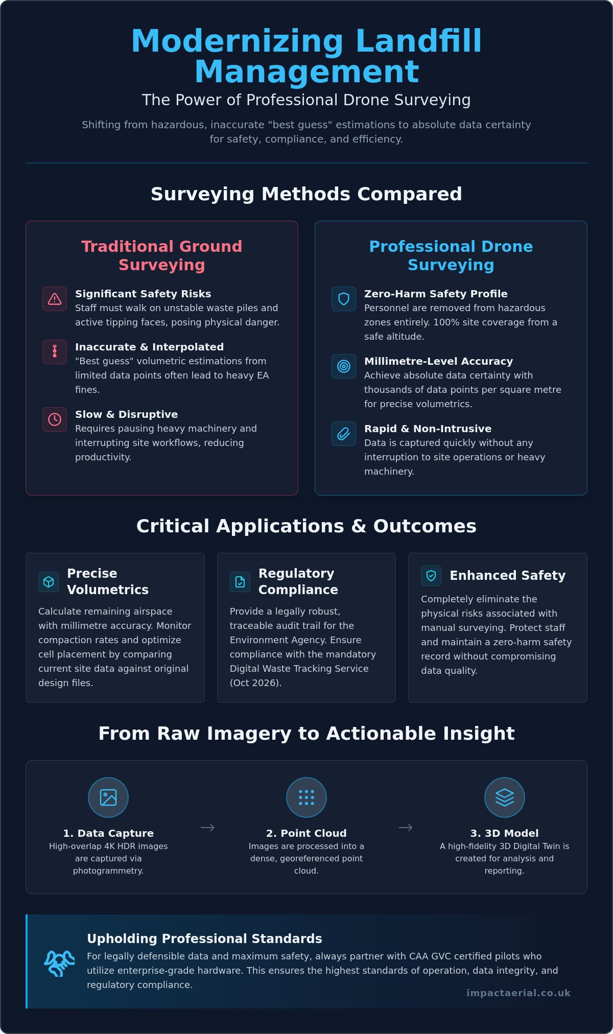
How much is a single centimetre of error worth when the Environment Agency is auditing your remaining airspace? For many UK landfill operators, traditional ground surveying isn’t just a slow process. It’s a significant safety liability that frequently results in “best guess” volumetric estimations. Walking on unstable waste piles to gather data puts staff at risk and often leads to the inaccurate reporting that triggers heavy EA fines. Integrating a professional drone survey for landfill sites changes this dynamic by shifting from interpolated estimation to absolute data certainty.

You’ll discover how millimetre-accurate volumetric data and high-resolution 3D site models provide a legally robust audit trail for your operations. We’ll outline how professional aerial surveys ensure compliance with the October 2026 mandatory Digital Waste Tracking Service while maintaining a zero-harm safety profile. From precise airspace calculations to reduced surveying costs, this guide explains how meticulous aerial data helps you navigate the increasingly strict regulatory environment with confidence and technical precision.

Key Takeaways

  • Eliminate the significant safety risks of manual ground surveying by transitioning to high-altitude aerial data capture for 100% site coverage.
  • Achieve millimetre-accurate volumetric reports that allow for precise remaining airspace calculations and compaction monitoring against original design files.
  • Ensure full regulatory compliance by utilizing a professional drone survey for landfill sites to provide the traceable topographical evidence required by the Environment Agency.
  • Gain superior data density with thousands of points per square metre, enabling the creation of high-resolution 3D models that far exceed traditional GPS capabilities.
  • Understand the operational necessity of hiring CAA GVC certified pilots who utilize enterprise-grade hardware to maintain the highest safety and data standards.

Why Drone Surveys are Essential for Modern Landfill Management

Modern landfill management requires a level of precision that manual methods simply cannot provide. UAV landfill surveying involves high-altitude data capture using specialized aircraft to perform topographical mapping and volumetric analysis. This shift from “walking the lines” with handheld GPS units to 100% aerial coverage allows for millimetre-level precision across the entire subject site. Beyond simple mapping, these surveys support critical environmental licensing requirements and are vital for the eventual surrender of licenses for closed sites. Precise data ensures that landfill gas monitoring and leachate management systems are accurately positioned and monitored according to strict environmental standards. The result is a zero-harm safety profile and a rapid data turnaround that provides site managers with actionable insights in a fraction of the time required by traditional methods. Operators no longer need to rely on “interpolated estimations” that can lead to regulatory friction; instead, they gain absolute data certainty.

To better understand how this technology is applied in real-world scenarios, watch this helpful video:

The Safety Advantage: Eliminating On-Site Hazards

Safety is the cornerstone of any industrial operation. Traditional surveying requires staff to traverse active tipping faces and unstable terrain, exposing them to significant physical risks. By using a drone survey for landfill sites, you remove personnel from these hazardous zones entirely. This transition eliminates the risk of vehicle-pedestrian interfaces during peak operational hours. Data is captured from a safe altitude, allowing site work to continue without the need to pause heavy machinery or interrupt complex workflows. This non-intrusive approach ensures that your site remains productive while maintaining the highest possible safety standards for all on-site personnel. It provides psychological comfort to management, knowing that accurate data doesn’t come at the cost of staff welfare.

From Raw Imagery to Actionable 3D Models

The technical process begins with photogrammetry. Here, 4K HDR images are captured with high overlap and processed into georeferenced point clouds. These point clouds form the basis of a Digital Elevation Model (DEM), which provides a clear visualization of the site’s topography. This technical output allows operators to see every contour and slope with absolute clarity, identifying potential drainage issues or slope instabilities before they become critical. In this context, a Digital Twin is a high-fidelity, georeferenced 3D digital replica of the landfill site that allows for real-time analysis and historical comparison of waste levels and site evolution. By comparing these models over time, you create a meticulous record of site changes that is invaluable for long-term planning and compliance auditing.

Critical Applications: Volumetrics, Airspace, and Compaction

Calculating remaining airspace is no longer a matter of interpolation or guesswork. A professional drone survey for landfill sites provides absolute data certainty by generating high-resolution 3D overlays that compare current site conditions against the original Top of Waste (TOW) design files. This process allows operators to identify overfill hotspots long before they lead to regulatory friction or the need for expensive remediation. By capturing millions of data points across the entire site surface, aerial surveys ensure that every cubic metre of licensed void space is accounted for with millimetre-level precision.

Maximizing Airspace Efficiency

Efficiency in waste management depends on knowing exactly how materials are settling. By using advanced cross-section analysis, site managers can track how waste compresses under the final cap. This Z-axis data is critical for refining cell placement strategies and optimizing the use of available space. As highlighted in the technical review on Applying Drone Technology to Landfills, integrating CAD design files with drone-captured 3D meshes allows for a level of precision planning that traditional ground surveys cannot match. You can visualize the current state of a cell versus its final design profile in a digital environment, allowing for proactive adjustments to daily tipping operations.

Compaction and Settlement Monitoring

Monitoring compaction rates is essential for ensuring the maximum utilization of your licensed void space. By comparing sequential surveys over time, drones generate detailed heat maps that visualize elevation changes across the site. These maps are invaluable for identifying “soft spots” or uneven settlement in closed cells that might otherwise go unnoticed. Unlike standard software-only solutions, a meticulous approach to data collection enables “Z-axis” cross-section analysis. This provides a clear view of how materials are compressing over weeks or months, ensuring the density of the waste meets engineering requirements. Identifying these trends early helps maintain site integrity and prevents the structural issues often associated with uneven settlement.

Effective management also extends to the logistics of cover soil and daily cell materials. Drones provide accurate volumes for these stockpiles in minutes, ensuring that you never run short of essential materials for site maintenance. This technical approach to aerial data collection ensures that every operational decision is backed by a precise, georeferenced audit trail. It’s a methodical process that turns raw imagery into a powerful management tool for modern waste facilities.

Drone Survey for Landfill Sites: Precision Waste Management & Compliance

Environmental Monitoring and UK Regulatory Compliance

Meeting Environment Agency (EA) requirements for topographical evidence is a fundamental part of modern waste management. The EA demands precise, verifiable data to monitor site status and ensure that operations remain within their permitted boundaries. A professional drone survey for landfill sites provides this evidence with a level of detail that ground-based teams cannot match. It creates a definitive georeferenced record that satisfies regulatory audits and provides a transparent history of site activity. For local authorities managing un-licensed closed landfill sites, aerial surveys are invaluable for delineating waste boundaries where historical records may be incomplete or inaccurate.

When commissioning a drone survey for landfill sites, the technical credentials of the flight team are paramount. It is essential to hire CAA GVC certified pilots who understand the complexities of industrial airspace. This certification isn’t just a badge; it’s a legal requirement for complex commercial operations that ensures the pilot has the competency to manage risks on high-hazard sites. Operating without these credentials or the appropriate insurance can lead to significant legal liabilities for the site operator.

Advanced sensor technology has expanded the scope of environmental monitoring beyond simple photography. Thermal and multispectral sensors can now detect early signs of leachate leaks or sub-surface gas migration by identifying thermal anomalies or vegetation stress. This proactive approach is backed by global standards, such as the guidance from the EPA on detecting landfill emissions with drones, which highlights how aerial platforms provide a safer and more comprehensive view of methane plumes than traditional ground-level “sniffing” methods.

LiDAR vs. Photogrammetry for Closed Sites

Choosing the right sensor depends on the lifecycle stage of the landfill cell. While photogrammetry is excellent for active tipping faces, LiDAR (Light Detection and Ranging) is essential for older, closed sites. LiDAR pulses can penetrate heavy vegetation and scrub, allowing us to create accurate terrain models of the ground surface beneath the canopy. This is critical for monitoring settlement or identifying drainage issues on sites that have been reclaimed by nature and are no longer easily accessible on foot.

Audit-Ready Data for License Surrender

Surrendering an environmental license is a meticulous process that requires proof of site stability. We provide 100% coverage surveys that serve as definitive topographical evidence for the EA during the surrender application. Maintaining a digital archive of these surveys offers long-term liability protection, proving the state of the site at the point of handover. To ensure total client security, professional operators maintain £5m commercial liability insurance, providing the necessary reassurance when working in high-risk waste environments.

Comparing Drone Surveys to Traditional Ground-Based Methods

The technical superiority of aerial data collection becomes most apparent when comparing data density. Traditional ground surveys rely on a surveyor manually capturing a few hundred GPS points across a site. This method results in an “interpolated” model, where software must estimate the terrain between those sparse data points. In contrast, a professional drone survey for landfill sites captures thousands of points per square metre. This creates an “absolute” model that reflects the true topography of the waste mass without the guesswork associated with manual sampling. This level of detail is essential for high-stakes decisions regarding remaining capacity and regulatory reporting.

Operational speed is another critical differentiator. Surveying a 50-acre landfill site on foot can take between two and three days of intensive field work. A specialized UAV can capture the same area in approximately 30 minutes. This massive reduction in man-hours doesn’t just lower costs; it makes frequent monitoring financially viable. Instead of annual or quarterly snapshots, operators can perform monthly or even weekly capacity checks to maintain a tighter grip on their compaction rates and tipping schedules. This efficiency allows for a more responsive management style that adapts to the daily realities of waste intake.

Accuracy and Precision Standards

Achieving survey-grade accuracy requires more than just a high-resolution camera. We utilize RTK (Real-Time Kinematic) drones and strategically placed Ground Control Points (GCPs) to ensure that every pixel is georeferenced with absolute precision. While ground teams struggle with the “interpolated” gaps in their data, our aerial approach provides a continuous 3D mesh. A continuous data blanket ensures that 100% coverage eliminates the risk of missing topographic anomalies that often fall between the gaps of sparse manual survey points. This precision is vital when calculating the financial value of remaining void space or preparing for an Environment Agency audit.

Operational Continuity

One of the most significant advantages of aerial surveying is the lack of site downtime. Ground teams often require heavy machinery to stop or move to different cells to ensure their safety, which disrupts the tipping workflow. Drones operate in the airspace above the site, allowing for zero-harm data collection while your plant remains fully operational. Furthermore, the ability to utilize thermal or LiDAR sensors means surveys can often proceed in varied weather conditions or lighting that would hinder traditional optical methods. This reliability ensures that your data collection schedule remains on track, regardless of the operational challenges on the ground.

If you’re ready to transition from manual estimations to absolute data certainty, our team provides comprehensive drone commercial property surveys and industrial mapping across the UK. We handle the technical complexity so you can focus on efficient site management. For operators who also need to manage transport compliance, you can explore Remote Tachograph Download with Fleetalyse to streamline your fleet’s data collection.

Partnering with Impact Aerial for Professional Landfill Surveys

Partnering with Impact Aerial provides a methodical transition from raw data to actionable site intelligence. We specialize in commercial drone surveys tailored specifically for the rigours of industrial waste environments. Our approach centers on utilizing high-specification DJI Enterprise hardware, which ensures the highest possible data integrity for your volumetric and compliance reporting. Beyond the flight itself, our comprehensive post-production services transform millions of georeferenced points into usable CAD and BIM formats. This allows your engineering teams to integrate aerial models directly into existing site management workflows without technical friction.

Safety is our primary operational pillar. Every mission begins with exhaustive risk assessments and CAA-approved flight planning to ensure total compliance with national aviation standards. We understand that landfill sites are high-risk environments with complex machinery and shifting terrains. Our protocols are designed to maintain a zero-harm safety profile while delivering the technical precision required by modern environmental regulations. It’s about providing the reassurance that your surveying needs are met by a compliant, professional operator.

Our Technical Capabilities

We deploy specialized 4K HDR and thermal-equipped enterprise drones to capture multi-layered data sets in a single flight. While we have deep experience working within the West Midlands, our team operates nationwide to support major waste operators across the UK. This geographical reach is balanced with a meticulous focus on data compatibility; we ensure our outputs integrate seamlessly with your site management software and long-term design platforms. Whether you’re monitoring an active cell or managing a closed site, our multi-sensor payloads provide the clarity needed for effective oversight.

Get a Professional Landfill Assessment

Starting a drone survey for landfill sites begins with a structured consultation to scope your specific data requirements. We perform a site feasibility study to identify the optimal flight paths and sensor choices for your terrain. Our pricing remains transparent, and we prioritize rapid report delivery to help you meet time-sensitive compliance deadlines or EA audit windows. This structured approach provides the psychological comfort of knowing your data is handled by vetted specialists who value industry standards as much as you do. We don’t just deliver images; we deliver the technical certainty required to manage your site’s future.

Contact Impact Aerial today for a bespoke drone survey quote.

Future-Proofing Your Waste Management Strategy

Transitioning to aerial data collection is no longer a luxury for UK landfill operators; it’s a regulatory and operational necessity. By replacing manual surveys with a professional drone survey for landfill sites, you eliminate the safety risks associated with unstable terrain while gaining millimetre-accurate volumetric data. This precision ensures that your remaining airspace calculations and compaction monitoring are based on absolute data certainty rather than interpolated guesswork. As the Environment Agency increases its focus on digital waste tracking, having a georeferenced audit trail becomes your strongest asset for long-term compliance and successful license surrender.

We provide the technical expertise and regulatory reassurance your facility requires. Our team of CAA GVC Certified Pilots operates with £5m Commercial Liability Insurance and utilizes expert DJI Enterprise Hardware to deliver high-tier results. Request a Professional Landfill Survey Quote today to secure a bespoke assessment for your site. Take control of your site’s data and safety profile with a solution built for the demands of modern waste management.

Frequently Asked Questions

How accurate are drone surveys for calculating landfill volume?

Drone surveys achieve millimetre-level precision, typically within 2-5cm vertical accuracy when using RTK or PPK-corrected datasets. This level of detail is essential for calculating remaining void space and monitoring compaction rates against original TOW design files. By capturing thousands of points per square metre, drones provide a far more reliable volumetric report than traditional ground-based sampling.

Does the drone interfere with active landfill machinery or GPS systems?

Drones don’t interfere with active landfill machinery or on-site GPS systems because they operate on distinct, regulated frequency bands. Modern enterprise drones use encrypted transmission protocols to ensure signal integrity in industrial environments. Since the survey takes place in the airspace above the site, operations can continue without interruption, maintaining total operational continuity and safety for ground personnel.

What UK regulations apply to flying drones on a landfill site?

Commercial drone operations on landfill sites must comply with CAA regulations, specifically requiring pilots to hold a General Visual Line of Sight Certificate (GVC). Operators must also adhere to Remote ID mandates starting January 1, 2026, for class-marked drones. These strict standards ensure that every flight is conducted within a legal framework that prioritizes site safety and data accountability.

Can drones detect landfill gas or leachate leaks?

Drones equipped with specialized thermal and multispectral sensors can identify the thermal signatures of leachate leaks and gas migration. While standard RGB cameras capture topographical data, these advanced sensors detect vegetation stress or temperature anomalies that indicate sub-surface issues. This proactive monitoring allows site managers to address environmental risks before they escalate into regulatory breaches or Environment Agency fines.

How often should a landfill site be surveyed by a drone?

The ideal frequency for a drone survey for landfill sites depends on waste intake volumes, but many operators opt for monthly or quarterly assessments. Frequent surveys allow for tighter control over compaction rates and more accurate monthly reporting to the Environment Agency. Regular data capture ensures that any overfill hotspots are identified early, preventing expensive remediation work at the end of the cell’s life.

What file formats are provided after a drone landfill survey?

Data’s typically delivered in industry-standard formats including .DXF and .DWG for CAD integration, and .OBJ or .PLY for 3D meshes. We also provide GeoTIFFs for orthomosaic mapping and .LAS or .LAZ files for detailed point clouds. These formats ensure that the aerial data integrates seamlessly with your existing Building Information Modelling (BIM) and site management software.

How long does it take to get the volumetric report after the flight?

Most volumetric reports are processed and delivered within 48 to 72 hours following the flight mission. While the data capture itself takes less than an hour for a typical 50-acre site, the post-production phase involves rigorous photogrammetric processing to ensure survey-grade accuracy. This rapid turnaround allows site managers to make data-driven decisions while the site conditions are still current and relevant to operations.

Is a drone survey cheaper than a traditional land survey?

Drone surveys are significantly more cost-effective than traditional land surveys due to the drastic reduction in field hours and personnel risk. A 50-acre site that would take days to survey on foot is completed in minutes from the air. This efficiency reduces the total man-hours required for data collection and processing, making high-frequency monitoring a financially viable option for modern waste facilities.

