Is your digital forecourt working as hard as your physical one, or are static images letting your most valuable inventory blend into the background? In a market where buyers expect immersive experiences, professional drone photography for car dealerships has evolved from a visual extra into a precision sales tool. You likely understand the frustration of high-value vehicles sitting idle simply because a standard photo gallery fails to capture the scale and prestige of your brand. It’s a common challenge to balance the need for high-impact content with the strict safety and regulatory demands of a busy commercial environment.
This 2026 guide reveals how professional aerial imagery and FPV fly-throughs can drive vehicle inquiries while ensuring your operations remain fully compliant and secure. We’ll examine the technical realities of modern drone use, including the mandatory £12.34 CAA Operator ID and the latest UK class mark requirements that took effect this January. You’ll discover how to increase your VDP views and streamline lot management through expert aerial perspectives, all while maintaining the rigorous safety standards and risk mitigation your business demands.
Key Takeaways
- Understand how high-precision drone photography for car dealerships elevates vehicle listings from static galleries to immersive digital narratives that drive inquiry rates.
- Explore the creative potential of FPV fly-throughs to provide buyers with a seamless journey from the forecourt directly into the driver’s seat.
- Learn how aerial data streamlines operational tasks like inventory capacity planning and rapid showroom roof inspections to mitigate facility risks.
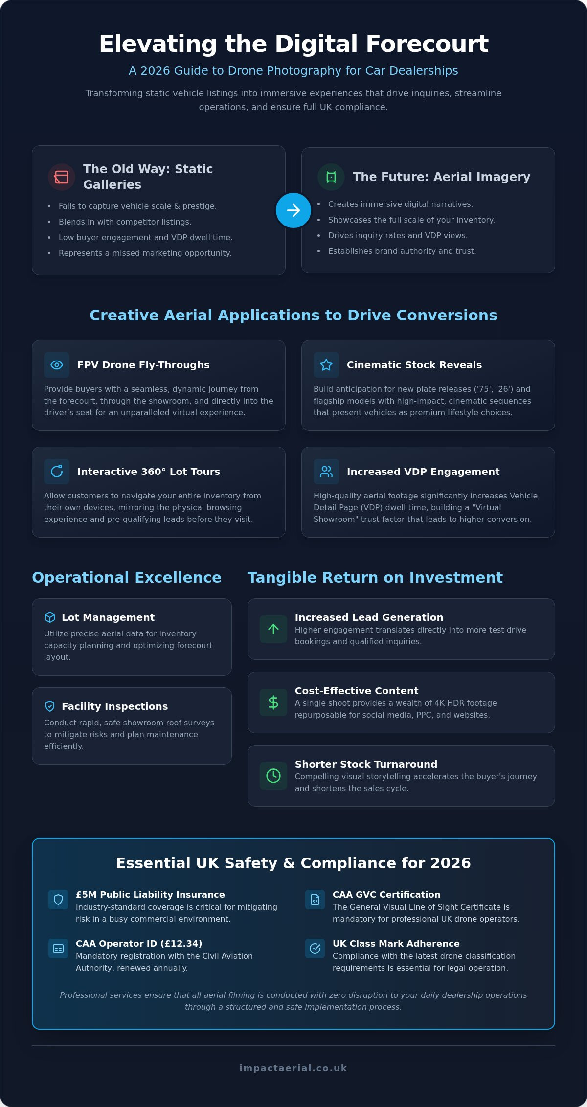
- Identify the critical UK regulatory requirements for 2026, including the necessity of CAA GVC certification and industry-standard £5m liability insurance.
- Discover the structured implementation process that ensures professional aerial filming is conducted with zero disruption to your daily dealership operations.
The Digital Forecourt: Why Drone Photography for Car Dealerships is Essential in 2026
Automotive retail has reached a point where the digital forecourt is no longer a secondary concern; it’s the primary gateway for every potential buyer. In 2026, drone photography for car dealerships has matured into a sophisticated, multi-layered marketing and operational asset. It provides a level of immersive storytelling that standard 2D imagery simply cannot replicate. While the history of aerial photography began with rudimentary perspectives, today’s professional drone services offer high-precision, AI-stabilized visuals that define a brand’s authority in a crowded market.
The shift toward immersive content is driven by buyer expectations. A modern consumer doesn’t just want to see a car; they want to experience the scale of your inventory and the professionalism of your facility. High-quality aerial footage significantly impacts Vehicle Detail Page (VDP) dwell time, keeping users engaged for longer periods. This increased engagement is a direct precursor to conversion, as it builds a “Virtual Showroom” experience that establishes trust before the customer even sets foot on your lot.
To better understand how these techniques are applied in a real-world setting, watch this helpful video:
Engaging the Modern Car Buyer
Aerial perspectives offer a unique sense of scale that’s particularly effective for large UK dealership groups. Capturing the full breadth of a 200-vehicle inventory in a single, sweeping shot provides a psychological reassurance of choice and stability. Professional drone imagery for car dealerships clearly outranks amateur mobile phone photography. While a salesperson’s handheld video might feel authentic, it often lacks the technical polish required to represent a premium brand. Meticulously planned flight paths demonstrate that your dealership values precision and quality in every aspect of its operation.
The ROI of Aerial Marketing for Automotive
Investing in professional aerial content yields tangible returns through increased lead generation and test drive bookings. A single, well-executed drone shoot provides a wealth of 4K HDR footage that can be repurposed across social media platforms, PPC campaigns, and website headers. This versatility makes it far more cost-effective than scheduling multiple ground-based video sessions. By utilizing high-end output for flagship launches or the latest plate releases, dealers can create a cinematic “event” feel that resonates with buyers and justifies the investment through higher engagement metrics and shorter stock turnaround times.
Driving Conversions: Creative Aerial Applications for Vehicle Listings
Static vehicle listings often struggle to convey the physical presence and prestige of a high-spec model. Professional drone photography for car dealerships solves this by providing a dynamic sense of motion and perspective that ground-level cameras cannot match. By using cinematic stock reveals, dealers can build significant anticipation for major events like the new “75” and “26” plate releases. These high-impact sequences don’t just show the car; they present it as a premium lifestyle choice, highlighting specific vehicle features using close-proximity drone maneuvers that emphasize design lines and interior craftsmanship.
Interactive 360-degree lot tours provide another layer of engagement, allowing customers to navigate your inventory from their own devices. This virtual walkthrough mirrors the physical experience of browsing a forecourt, effectively pre-qualifying leads before they arrive on-site. When buyers can “walk” the dealership virtually, the friction of the initial visit is reduced, leading to more purposeful showroom appointments.
FPV Drone Fly-Throughs for Showrooms
First Person View (FPV) drones are the most significant advancement in dealership marketing for 2026. Unlike standard GPS-stabilized drones, FPV aircraft can navigate tight spaces with surgical precision. This allows for a continuous “one-take” shot that starts on the forecourt, glides through the showroom doors, and finishes directly in the driver’s seat. Utilizing FPV in the UK creates a visceral connection with the viewer, providing a bird-eye-to-eye-level perspective that is perfect for viral social media content. These flights aren’t just about the cars; they showcase your entire facility, including service bays, luxury lounges, and cafes, to build customer comfort. Every flight is meticulously planned to remain compliant with UK drone safety regulations, ensuring total protection for your staff and high-value inventory.
Post-Production: Turning Raw Footage into Sales Assets
The transition from raw footage to a high-converting sales asset occurs in the post-production suite. Professional color grading is essential to match the premium feel of high-end automotive brands, ensuring that paint finishes look vibrant and accurate across all screens. Adding digital overlays, such as monthly finance rates, performance specs, or clear calls-to-action, transforms a cinematic video into a functional tool for your sales team. These master files can then be edited into short-form “Reels” and “TikToks,” allowing you to maintain a consistent, high-quality brand presence across all digital channels. To further enhance the customer experience within your facility, these assets can be displayed on digital menu boards Ireland to provide a modern, interactive touchpoint in the showroom.
If you’re ready to enhance your dealership’s visual strategy, exploring professional Aerial Filming and Photography can provide the competitive edge needed to dominate the digital forecourt.
Operational Excellence: Using Drones for Lot Management and Surveys
While many view drone photography for car dealerships purely as a marketing asset, its utility extends deep into operational management. Precision aerial data allows dealer principals and facility managers to oversee large sites with a level of detail that ground-level inspections cannot match. Transitioning from visual marketing to data-driven logistics turns a drone from a camera into a vital facility management tool. This shift is essential for dealerships in 2026 that aim to maximize every square meter of their forecourt while minimizing maintenance overheads.
Showroom Maintenance and Roof Surveys
High-value showrooms and workshops require meticulous upkeep to protect both the building fabric and the inventory within. Traditional inspections often involve the significant cost and disruption of erecting scaffolding or hiring cherry pickers. A professional drone survey provides a non-invasive alternative, capturing high-resolution imagery of roof structures in a fraction of the time. This rapid data collection is essential for identifying gutter blockages, loose flashing, or solar panel defects before they lead to internal leaks.
The speed of drone-led inspections is a major advantage. A manual survey that might take a full day can be completed in under an hour with a drone. Additionally, technical sensors can identify heat loss in showroom glazing or detect malfunctioning cells in rooftop solar installations. These insights allow for proactive repairs, ensuring your facility remains energy-efficient and operational without the need for staff to work at height.
Inventory Mapping and Site Planning
Logistics on a busy forecourt are notoriously complex. Professional drones can generate 2D orthomosaic maps, which are essentially high-definition, top-down blueprints of the entire site. These maps are invaluable for lot capacity planning and inventory management. If you’re planning a tent sale or a seasonal lot reconfiguration, visualizing the space from above ensures that vehicle spacing is optimized and traffic flow is maintained. It removes the guesswork from site planning, allowing for precise placement of flagship models and promotional displays.
Security is another critical application for aerial data. By mapping the site from above, you can identify blind spots in existing forecourt CCTV coverage. This ensures that your most valuable stock is protected around the clock. All these operations are conducted in strict adherence to UK Civil Aviation Authority drone regulations. This meticulous approach to compliance ensures that while we gather critical facility data, the safety of your staff, customers, and expensive vehicle inventory remains the absolute priority.
Safety and Compliance: Essential Rules for UK Dealership Drone Flights
Executing professional drone photography for car dealerships requires more than just technical skill behind the lens; it demands a rigorous commitment to aviation safety and legal compliance. When you’re operating a drone in close proximity to millions of pounds of vehicle inventory and high-traffic customer areas, the margin for error is zero. Meticulous planning and adherence to national regulations ensure that your marketing assets are captured without exposing your business to significant liability or physical risk.
Safety begins with a comprehensive pre-flight site survey. This process identifies potential hazards such as overhead power lines, high-intensity forecourt lighting, and nearby flight restriction zones. For dealerships located near regional hubs, such as Birmingham Airport, professional operators must coordinate directly with Air Traffic Control (ATC) to secure the necessary flight permissions. This level of officialdom is what separates a professional service from an amateur hobbyist and is essential for maintaining the integrity of your dealership’s brand.
The Importance of CAA Certification
In the UK, any pilot operating a drone for commercial purposes must hold the correct credentials. For dealership environments, which are often classified as congested areas, the CAA General Visual Line of Sight Certificate (GVC) is the industry benchmark. This UK drone license allows pilots to operate in the “Specific” category, granting the legal authority to fly closer to buildings and people than is permitted under standard recreational rules. Hiring an uncertified pilot doesn’t just risk a £1,000 fine for improper registration; it potentially invalidates your business insurance and places your dealership at severe legal risk if an incident occurs.
Managing “involved persons” is a critical part of this compliance. A professional pilot ensures that all staff on-site are briefed on the flight plan, effectively turning them into “involved persons” who understand the safety protocols. This allows the dealership to remain open and operational during the shoot, provided that members of the public are kept at a safe, regulated distance from the flight path.
Insurance and Liability on the Forecourt
Standard public liability insurance is rarely sufficient for the specialized risks of an active car lot. The industry standard for automotive sites is a minimum of £5m commercial liability insurance, specifically tailored for drone operations. This coverage provides the psychological comfort and financial security required when flying over high-value stock. At Impact Aerial, we prioritize risk mitigation through documented emergency protocols and strict adherence to the latest 2026 Remote ID requirements. Our approach ensures that every flight is transparent, accountable, and fully insured. If you require a partner who values safety as much as visual impact, you can book a professional drone consultation to discuss your site requirements.
Implementing Your Drone Strategy: The Impact Aerial Process
Transitioning from traditional photography to a comprehensive aerial strategy requires a methodical approach that prioritizes both visual quality and operational safety. Implementing professional drone photography for car dealerships isn’t a one-size-fits-all task; it’s a structured process designed to align with your specific commercial goals. Our workflow begins with an initial consultation to identify whether your primary objective is driving VDP views for flagship models, conducting facility surveys, or a combination of both. This goal-oriented start ensures that every flight minute is optimized for maximum return on investment.
The second phase involves a detailed site survey and flight planning session. We understand that a dealership is a live environment where customer experience is paramount. Our pilots plan missions to ensure zero disruption to your daily operations, often scheduling flights during golden hour or specific windows that minimize impact on foot traffic. On the shoot day, we utilize commercial-grade DJI Enterprise hardware. These systems offer superior stability and high-end sensors that capture 4K HDR footage, even in the challenging lighting conditions often found on modern forecourts. The process concludes with the delivery of ready-to-use assets, meticulously edited and formatted for immediate integration into your website, social media channels, and digital showroom displays.
Tailored Solutions for UK Dealer Groups
Managing a multi-site automotive franchise requires a partner capable of scaling professional drone services across various regional locations. We provide custom packages that allow dealer groups to maintain a consistent brand image across all sites. These packages often combine high-impact marketing photography with essential survey data, providing a holistic view of your estate. Whether you need monthly inventory updates to coincide with new plate releases or seasonal facility monitoring to check for winter roof damage, our team provides the ongoing technical support needed to keep your digital and physical forecourts in peak condition.
Getting Started with Professional Aerial Content
Before booking a provider, it’s vital to ask specific questions regarding their CAA credentials, insurance limits, and emergency protocols. A professional operator should be able to provide documented risk assessments and proof of their GVC certification immediately. To prepare your lot for a shoot, we recommend ensuring vehicle alignment is perfect and that all high-value stock is clean; the drone’s high-resolution sensors will pick up every detail. If you’re ready to transform your marketing and lot management with precision aerial data, you can Contact Impact Aerial for a bespoke dealership quote today. Our meticulous approach ensures your brand is presented with the authority and quality your inventory deserves.
Future-Proofing Your Dealership’s Visual Identity
The automotive landscape in 2026 demands a sophisticated blend of immersive marketing and data-driven operations. By integrating professional drone photography for car dealerships, you don’t just showcase your inventory; you provide a transparent, high-precision view of your entire facility. This dual-purpose technology bridges the gap between creative storytelling and meticulous lot management, ensuring your brand remains authoritative and your assets stay secure. From cinematic FPV showroom tours to rapid, non-invasive roof surveys, the advantages of aerial data are clear and measurable.
Impact Aerial provides the technical expertise and regulatory reassurance required to operate safely on busy commercial forecourts. Our Birmingham-based team offers UK-wide coverage, utilizing 4K HDR cinema-grade DJI Enterprise drones to deliver industry-leading output. With CAA GVC Certified Pilots and £5m Commercial Liability Insurance, we manage every operational risk so you can focus on driving conversions. Elevate your dealership with professional drone photography—Request a quote from Impact Aerial today. We look forward to helping you define a new standard of excellence for your digital forecourt.
Frequently Asked Questions
Do I need to close my dealership during a drone shoot?
No, you don’t need to close your dealership during a professional drone shoot. Our pilots conduct thorough risk assessments to manage the safety of staff and customers, categorizing them as involved persons through brief safety inductions. This meticulous approach allows your sales operations to continue without interruption while we capture high-impact visuals for your digital forecourt.
Is it safe to fly drones near high-value vehicles?
Flying drones near high-value vehicles is entirely safe when conducted by a CAA GVC certified pilot using enterprise-grade hardware. We utilize precision DJI Enterprise aircraft equipped with advanced obstacle avoidance and stabilized high-definition sensors. This ensures that every maneuver is executed with surgical accuracy, maintaining a safe distance while delivering cinematic drone photography for car dealerships.
What UK drone laws apply to car dealerships?
Several specific regulations apply, including the mandatory £12.34 annual CAA Operator ID and the requirement for Remote ID broadcasting which became effective for most class-marked drones in January 2026. For commercial sites in congested areas, a GVC is essential. These rules ensure legal accountability and airspace safety, protecting your dealership from the significant fines associated with non-compliance.
Can drone footage be used for both marketing and roof surveys?
Yes, a single mission can be structured to capture both marketing content and technical survey data. We can provide 4K HDR footage for your vehicle listings and high-resolution imagery for commercial property surveys during the same site visit. This multi-layered approach maximizes your investment by addressing both sales engagement and facility maintenance needs in one session.
How much does professional drone photography for car dealers cost?
The cost of drone photography for car dealerships depends on the project’s complexity, the number of sites, and the required post-production depth. Professional rates reflect the pilot’s technical qualifications, the use of high-tier hardware, and the comprehensive £5m liability insurance necessary for automotive environments. We provide bespoke quotes tailored to the specific marketing or operational goals of your dealer group.
What happens if the dealership is near an airport or restricted zone?
If your site is located within a Flight Restriction Zone, we handle the entire coordination process with local Air Traffic Control. This involves securing official flight permissions and maintaining radio contact with the airport during the shoot. Our experience with regional hubs ensures that even restricted sites can legally benefit from professional aerial filming and photography.
How long does it take to get the final edited drone videos?
Final edited assets are typically delivered within a few business days following the shoot. This timeframe allows our post-production team to perform professional color grading and add digital overlays like pricing or specifications. We prioritize a structured workflow to ensure the output matches the premium standards of your automotive brand and is ready for immediate deployment.
Do you provide FPV drone tours for showroom interiors?
We provide specialized Virtual Tour Creation using FPV drones to navigate tight showroom interiors with precision. These flights offer a unique perspective that takes viewers from the forecourt directly through the showroom doors and into the driver’s seat. It’s a highly effective way to showcase your facilities, including service bays and luxury lounges, to build customer comfort.