
Drone Virtual Tours for Real Estate: The Ultimate Property Marketing Edge in 2026

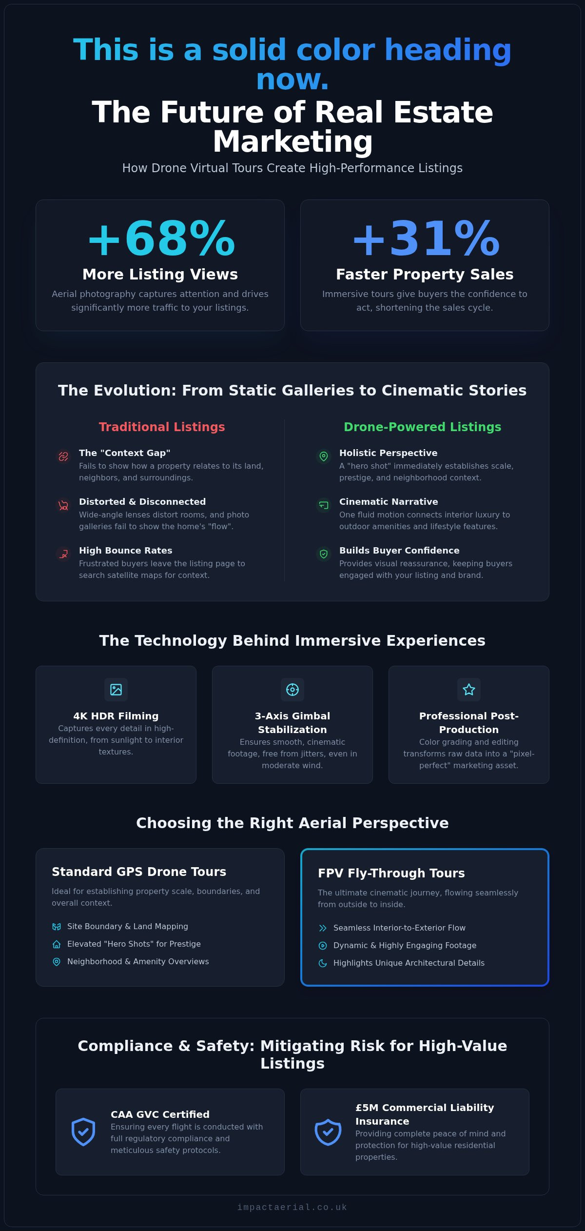
Did you know that listings featuring aerial photography receive 68% more views and sell 31% faster than those without? In the competitive 2026 market, standard image galleries often fail to convey the true scale and flow of a property. You’ve likely noticed that static photos just can’t capture the relationship between a luxury home and its surroundings, which frequently leads to high bounce rates from frustrated buyers who can’t get a feel for the layout.

We understand that professional drone virtual tours for real estate are no longer just a luxury; they’re a narrative tool that connects a property to its lifestyle in a single, cinematic flow. This article explores how these immersive experiences transform your listings into high-performance marketing assets that attract international interest and sell homes faster. We’ll examine the technical precision of 4K HDR filming, the rising demand for FPV fly-throughs, and the critical importance of CAA GVC certification to ensure every flight is conducted with meticulous safety and full regulatory compliance.

Key Takeaways

  • Understand why standard 360 tours are no longer sufficient for 2026 buyers and how aerial perspectives bridge the gap between interior detail and neighbourhood context.
  • Discover how drone virtual tours for real estate utilize 4K HDR filming and DJI Enterprise hardware to create immersive, high-definition experiences that capture every property detail.
  • Learn to distinguish between standard GPS drone shots for site boundaries and FPV fly-throughs that provide a seamless cinematic journey from the garden to the living room.
  • Identify the critical compliance requirements, such as CAA GVC certification and £5m commercial liability insurance, necessary to mitigate risk for high-value residential listings.
  • Explore how professional post-production services transform raw aerial data into “pixel-perfect” marketing assets that build your reputation as a tech-forward agency.

The Evolution of Property Marketing: Why Standard 360 Tours Aren’t Enough

Property marketing has undergone a significant shift. By 2026, the expectations of high-end buyers have moved beyond simple photo galleries and basic walkthroughs. While Virtual tour technology has been a staple of the industry for years, traditional ground-based solutions often suffer from a “context gap.” They provide an excellent view of the kitchen or the master suite, but they fail to show how the property sits within its environment. This lack of perspective creates a disconnected experience, leaving potential buyers wondering about the proximity of neighbors, the true scale of the grounds, or the quality of the surrounding neighborhood.

Professional drone virtual tours for real estate bridge this gap by providing a holistic view that ground-based cameras simply cannot replicate. Data indicates that listings featuring aerial perspectives receive 68% more views and sell 31% faster on average. This isn’t just about a pretty picture; it’s about providing the technical data and visual reassurance that modern buyers require before they commit to a physical viewing. To better understand how this technology creates a seamless narrative, watch this example of an immersive aerial walkthrough:

The Problem with Static Listing Content

Static photos and standard 360 tours often feel clinical and disconnected. When a buyer clicks through a gallery, they struggle to visualize the “flow” of a home, especially in properties with complex layouts or expansive estates. This confusion leads to high bounce rates on listing pages. Ground-based wide-angle lenses can also distort rooms, creating an unrealistic expectation that leads to disappointment during in-person visits. Without an aerial perspective, the relationship between the front door, the garden, and local green spaces remains a mystery, forcing the buyer to do their own research on satellite maps rather than staying engaged with your listing.

Drones as the Ultimate Narrative Tool

Utilizing drone virtual tours for real estate transforms a listing from a simple viewing into a compelling story. By starting with a “hero shot” from an elevated perspective, you immediately establish the property’s scale and prestige. Drones allow us to connect the interior luxury of a home to its external environment in one fluid motion. We can show the transition from a sun-drenched patio to the local parkland or nearby amenities, providing the lifestyle context that 2026 buyers prioritize. This technical approach ensures that every pixel serves a purpose, building a brand reputation for your agency as a technologically adept leader that values precision and quality.

How Drone Technology Creates Immersive Real Estate Experiences

A drone virtual tour for real estate is a high-definition, interactive video or 360-degree experience captured via an Unmanned Aerial Vehicle (UAV). Unlike traditional video walkthroughs, these tours provide a continuous, interactive path that allows potential buyers to explore a property from perspectives that were previously impossible to achieve. The goal is to move beyond simple observation and create a sense of presence, where the viewer feels they are physically navigating the space and its surroundings.

The technical foundation of these experiences relies on 3-axis gimbal stabilization and high-bitrate recording. This hardware ensures that even in moderate winds, the footage remains smooth and cinematic, devoid of the jitters or “jello effect” common in consumer-grade equipment. Once the flight is complete, the raw data enters a rigorous post-production phase. This is where professional editors stitch together panoramas, color-grade the footage for a “pixel-perfect” finish, and transform raw files into an interactive marketing asset that functions seamlessly across mobile and desktop platforms.

The Hardware: DJI Enterprise and 4K HDR

We utilize DJI Enterprise grade drones because they offer superior sensor sizes and reliability compared to standard retail models. These systems are equipped with 4K HDR cameras that excel at capturing dynamic range, which is critical during “golden hour” shoots where the sky is bright but the property remains in shadow. The use of 4K HDR technology allows for the precise rendering of property textures, ensuring that the natural grain of timber cladding or the intricate patterns of stonework are captured with absolute clarity. This technical precision provides the high-tier quality that luxury listings demand to maintain their market positioning.

Interactive Elements and Hotspots

Modern tours are no longer passive viewing experiences. By embedding clickable info-points or “hotspots,” agents can highlight specific selling points, such as premium appliance brands or smart home integrations, directly within the aerial view. We also integrate 360-degree panoramas at varying altitudes, giving buyers the ability to “look around” from 50 feet in the air. This interactive layer is often linked to broader virtual tour creation workflows, allowing a user to click on the roof to see a detailed survey or click the front door to enter an internal walkthrough. Utilizing professional aerial filming and photography ensures these transitions are seamless and technically sound, providing a reliable experience for out-of-area investors.
Drone Virtual Tours for Real Estate: The Ultimate Property Marketing Edge in 2026

FPV vs. Standard Drone Tours: Choosing the Right Perspective

Selecting the appropriate flight methodology is a critical decision in the pre-flight planning phase. Not all properties require the same visual approach, and the choice between standard GPS-stabilised drones and First-Person View (FPV) systems depends entirely on the marketing objective. While one provides a steady, authoritative overview of the land, the other offers a high-speed, immersive journey that captures the “feeling” of living in the space. Integrating both perspectives into drone virtual tours for real estate ensures that you provide the technical data a buyer needs alongside the emotional narrative they want.

The “One-Shot” technique has emerged as the gold standard for luxury listings in 2026. This involves a single, continuous flight path that starts high above the property, descends toward the front door, and flies through the interior before exiting into the rear garden. It’s a seamless journey that eliminates the disjointed feeling of clicking through separate room photos. This method requires a pilot with exceptional spatial awareness and technical skill, as there’s no room for error when navigating through a multi-million-pound residence.

When to Use Standard Aerial Photography

Standard GPS drones are the industry workhorse for establishing geographical context. They are the superior choice when your primary goal is to showcase large land parcels, precise site boundaries, or the structural condition of a roof. This approach is particularly effective for commercial real estate and industrial sites across the West Midlands, where proving proximity to transport hubs like the M6 or Birmingham’s logistics corridors is a key selling point. Standard drones provide a rock-steady platform for high-resolution imagery. For a detailed look at how we capture these high-resolution stills, refer to our comprehensive guide on drone photography.

The Rise of the FPV “Indoor-Outdoor” Tour

FPV drones, specifically “cinewhoop” models, have revolutionised the way we market luxury urban apartments and modern estates. These micro-drones are equipped with shrouded propellers, allowing them to safely navigate through tight doorways and around high-end furniture without risk. They create a high-octane, modern feel that resonates with a younger, tech-forward demographic. Capturing a fluid transition from a sun-drenched balcony into a sleek kitchen requires professional FPV piloting skills that go far beyond standard flight certifications. In the UK, this level of precision is essential for maintaining safety standards while delivering a cinematic experience that keeps viewers on the page for longer. This technical mastery is what separates a basic recording from a professional marketing asset.

Compliance and Planning: What Real Estate Professionals Need to Know

Operational safety and legal compliance are the foundations of any professional aerial project. While the visual output of drone virtual tours for real estate is what sells the property, the regulatory framework behind the flight is what protects your agency’s reputation. Real estate professionals must treat drone operations as technical missions rather than casual photography sessions. This starts with ensuring that every pilot holds a current CAA GVC certification, which is the standard for professional competency in the UK.

This qualification is non-negotiable for commercial work. It signifies that the pilot has undergone rigorous training in flight safety, meteorology, and air law. Without this, any footage captured for a commercial listing is technically illegal, which can lead to significant fines for both the operator and the hiring agency. We treat every flight with the same meticulous attention to detail that we apply to our aerial filming and photography services, ensuring that risk is mitigated before the drone even leaves the ground.

Navigating UK Drone Laws in 2026

Flight restrictions vary significantly depending on the property’s location. Capturing a luxury apartment in Birmingham city centre requires a different level of planning than a rural estate in the West Midlands. Congested areas demand specific permissions and a higher degree of risk mitigation. We manage the entire process, from securing CAA permissions to drafting detailed Risk Assessment Method Statements (RAMS). A professional drone license acts as a badge of accountability, ensuring that all operations adhere to the latest safety standards.

Risk Mitigation and Reassurance

Privacy and data protection are paramount when flying in residential areas. We adhere to strict GDPR guidelines, ensuring that identifiable data like car registrations or neighboring windows are managed appropriately during post-production. Our pre-flight site assessments include several critical steps:

  • Verifying airspace restrictions and local bylaws via official aviation charts.
  • Notifying local authorities or neighbors when operating in sensitive areas.
  • Establishing secure takeoff and landing zones to ensure public safety.

Relying on unlicensed hobbyists or “discount” operators puts your business at massive legal risk. If an accident occurs during a flight, an unlicensed pilot’s insurance is often void, leaving the estate agency liable for damages. Our £5m commercial liability insurance provides absolute reassurance and financial security for high-value properties and their owners. If you want to ensure your next marketing campaign is fully compliant and professionally executed, you can partner with Impact Aerial for your next property tour.

Partnering with Impact Aerial for Professional Virtual Property Tours

Selecting a provider for drone virtual tours for real estate requires more than just finding a pilot with a camera. It demands a technical partnership where the provider assumes all operational risk and regulatory responsibility. We position ourselves as technical consultants for your agency. This approach allows you to focus on the core business of selling properties while we deliver the high-tier visual assets required to attract serious, high-value buyers. Our commitment to precision ensures that every tour is not just a video, but a reliable data set that accurately represents the property.

We provide customized packages designed to meet the specific needs of both residential estate agents and commercial developers. Whether you’re marketing a single luxury residence or a multi-unit industrial complex, our team scales its operations to match the project’s scope. We handle the complexities of flight planning, safety protocols, and post-production, providing a seamless end-to-end service that integrates directly into your existing marketing workflows.

Our Process: From Brief to Broadcast

Every project begins with a creative planning session and a preliminary site survey. We don’t just show up and fly; we analyze the property’s orientation, lighting conditions, and potential flight hazards to ensure a safe and successful mission. During the execution phase, we utilize DJI Enterprise grade hardware to capture 4K HDR footage, ensuring the highest possible dynamic range and “pixel-perfect” detail. Our post-production team then takes over, meticulously editing the raw data to create a fluid, interactive experience. We understand that property launches are often time-sensitive, so we’ve optimized our internal processes to provide rapid turnaround times without sacrificing the quality of the final output.

Why Choose a Specialized UK Operator?

Our deep regional expertise in Birmingham and the West Midlands provides a distinct advantage for local property professionals. We understand the specific logistical challenges and airspace restrictions of the region, ensuring that every flight is conducted with total compliance. While our primary focus is the Midlands, we provide nationwide UK coverage, maintaining the same rigorous standards for every client. We’re committed to the highest drone services standards, ensuring that every project is backed by our CAA GVC certification and £5m commercial liability insurance. This level of professional accountability is essential for protecting your brand and your clients’ assets.

Ready to transform your property marketing with cinematic aerial experiences? You can request a consultation for your next real estate project to discuss your specific requirements and learn how our technical expertise can help you sell homes faster in 2026.

Securing a Competitive Advantage in 2026

The transition from static galleries to immersive, narrative-driven marketing is no longer optional for high-tier listings. By integrating drone virtual tours for real estate, agencies can bridge the context gap that traditional photography leaves behind, offering buyers a holistic view of both the property and its surrounding lifestyle. Whether you require the steady precision of standard GPS aerials or the high-octane flow of an FPV indoor fly-through, the technical execution must be flawless to maintain your brand’s reputation for quality.

Safety and compliance remain the most critical components of any aerial operation. Our team of CAA GVC Certified Pilots handles every aspect of flight planning and risk mitigation, backed by £5m commercial liability insurance. As a Birmingham-based specialist with UK-wide coverage, we provide the technical consultancy you need to launch properties with confidence and precision. We handle the technology so you can focus on closing the sale.

Don’t let your listings get lost in a sea of static photos. Book a Professional Drone Virtual Tour for Your Property Listing and give your clients the immersive cinematic experience they expect. We look forward to helping you transform your next property marketing campaign into a high-performance visual asset.

Frequently Asked Questions

Are drone virtual tours legal for residential properties in the UK?

Yes, drone virtual tours for real estate are entirely legal provided they are conducted by a pilot holding the correct Civil Aviation Authority (CAA) certifications. For commercial work in residential areas, a GVC (General Visual Line of Sight Certificate) is the professional standard. Pilots must also adhere to strict privacy laws and GDPR requirements to ensure that neighboring properties and uninvolved persons are not captured without appropriate justification or data management protocols.

How much do drone virtual tours for real estate typically cost?

The cost of a drone virtual tour depends on several technical factors rather than a single flat rate. Key variables include the size of the property, the complexity of the flight path, and the level of post-production required for a pixel-perfect finish. Urban locations in city centres like Birmingham may also require additional planning for airspace permissions, which influences the total project investment. We provide bespoke quotes based on your specific marketing objectives.

Can drones fly inside a house for a virtual tour?

Drones can safely fly indoors when using specialized FPV (First Person View) equipment. These “cinewhoop” drones feature shrouded propellers that prevent damage to interiors or high-end furniture. This technology allows for a seamless transition from the garden through the front door and into the living spaces. It creates an immersive, cinematic walkthrough that standard ground-based cameras cannot match, providing a continuous narrative of the home’s layout and flow.

How long does it take to shoot and edit a drone property tour?

A typical on-site shoot lasts between one and three hours depending on the property’s scale and the complexity of the flight plan. The post-production phase is more intensive, as raw 4K HDR data must be color-graded and edited into a fluid marketing asset. Most professional tours are delivered within three to five business days. This timeline ensures that every transition is smooth and the final output meets industry leadership standards for quality.

Do I need to notify the neighbours before a drone shoot?

While not a strict legal requirement for all flight categories, notifying neighbours is a highly recommended best practice for risk mitigation. Transparency helps manage privacy concerns and ensures the operation proceeds without interruption. As part of our pre-flight site assessment, we advise on the best way to communicate with local residents. This professional approach maintains the reputation of your agency and provides reassurance to the property owner that the shoot is compliant.

What happens if the weather is bad on the day of the drone flight?

Safety is our absolute priority, so flights are rescheduled if weather conditions fall outside of safe operational limits. High winds, heavy rain, or low visibility can compromise the aircraft’s stability and the quality of the 4K HDR footage. We monitor meteorological data meticulously in the days leading up to a shoot. If conditions are unsuitable, we coordinate with the agent to find the next available window with clear skies and optimal lighting.

What qualifications should a drone pilot have for real estate work?

A professional drone pilot must hold a CAA GVC certification to operate legally for commercial real estate projects in the UK. This qualification ensures the pilot understands air law, safety protocols, and technical flight requirements. Additionally, they should carry a minimum of £5m commercial liability insurance. These credentials provide the necessary legal protection and technical reassurance that your high-value property listings are in expert, compliant hands.

Are drone tours compatible with Rightmove and Zoopla?

Drone virtual tours for real estate are fully compatible with major UK portals like Rightmove and Zoopla. These platforms allow you to embed video content or link directly to interactive virtual tour experiences within the listing. Including an aerial tour can significantly increase time-on-page and engagement levels. This compatibility ensures that your tech-forward marketing reaches the widest possible audience, including international investors and out-of-area buyers who rely on immersive digital content.
Using Drone Footage to Sell Property Faster: The Professional Guide for 2026

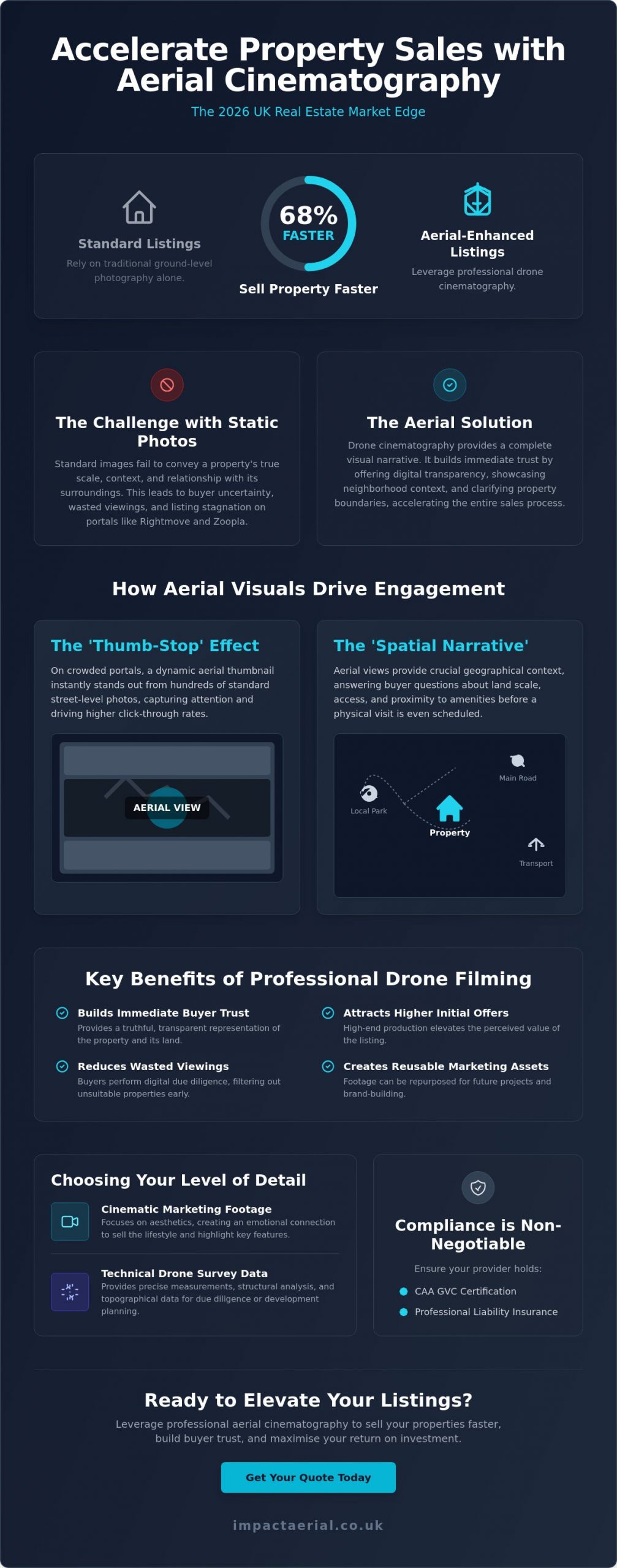
Did you know that property listings featuring professional aerial cinematography sell approximately 68% faster than those relying solely on traditional ground-level photography? In the 2026 real estate market, using drone footage to sell property faster has transitioned from a high-end luxury to a technical necessity for any serious listing. You likely understand the frustration when a premium property sits on the market because static images fail to convey its true scale or its relationship with the surrounding landscape. It is a common challenge for agents who know a home’s value but struggle to demonstrate its context to remote or discerning buyers.

We believe that high-quality visual data is the key to building immediate trust with potential leads. This guide will show you how professional aerial cinematography and technical precision can eliminate buyer uncertainty and drive deep emotional engagement. You’ll learn the specific visual techniques that increase lead quality and how to maintain strict safety and privacy standards while standing out on portals like Rightmove and Zoopla. From FAA compliance to post-production excellence, we provide the expert roadmap you need to accelerate your transaction times and ensure your properties receive the attention they deserve.

Key Takeaways

  • Learn how to leverage the ‘Thumb-Stop’ effect on major portals like Rightmove and Zoopla to capture buyer attention immediately.
  • Understand how a ‘Spatial Narrative’ provides the geographical context and structural transparency required to build immediate buyer trust.
  • Discover a proven five-step strategy for using drone footage to sell property faster by optimising your visual assets for maximum online exposure.
  • Identify the specific scenarios where a listing requires technical drone survey data instead of standard cinematic marketing footage.
  • Verify the critical legal requirements, including CAA GVC certification and professional liability insurance, to ensure your property marketing remains fully compliant.

The Impact of Aerial Visuals on Real Estate Sales Velocity

Sales velocity represents the specific duration between a property listing going live and the acceptance of a formal offer. In the competitive UK market, particularly on platforms like Rightmove and Zoopla, listings that fail to capture interest within the first 14 days often face the risk of stagnation. Using drone footage to sell property faster addresses this by creating an immediate ‘Thumb-Stop’ effect. When a potential buyer scrolls through hundreds of similar street-level photos, a high-altitude thumbnail provides instant visual variety. This perspective signals a premium listing and encourages a significantly higher click-through rate compared to traditional photography.

This visual engagement is backed by professional market data. Statistics from early 2026 indicate that listings featuring aerial components sell 68% faster than those relying solely on ground-based imagery. This isn’t just because the visuals are aesthetically pleasing; it’s because they deliver a higher volume of geographic information in a shorter timeframe. Buyers can immediately assess the property’s relationship with its environment, which is a critical factor in the digital-first viewing process. If you are interested in how these standards apply to the rental sector, you can discover KASA Tech for high-quality residential properties across the UK.

To better understand how these visuals transform the selling process, watch this short analysis of drone impact on sales speed:

The 2026 Buyer: Why Digital Transparency Wins

Modern buyers are research-driven and demand a high level of digital transparency before committing to a physical visit. They use aerial perspectives to perform their own due diligence on the surrounding area, checking for property boundaries, garden scale, and proximity to local infrastructure. While the history of aerial photography shows a transition from niche surveillance to accessible cinematography, the core value remains grounded in providing context. 4K HDR footage provides a truthful representation of the land, which builds early rapport and trust. By providing this information upfront, agents effectively reduce ‘wasted’ physical viewings from buyers who might have otherwise been deterred by the local geography only after arriving on-site.

Quantifying the ROI of Professional Drone Filming

The financial benefits of professional filming extend beyond just a quick transaction. Properties marketed with comprehensive aerial data often attract higher initial offers because the perceived value of the listing is elevated through high-end production. For property developers, using drone footage to sell property faster also creates a permanent marketing asset that can be repurposed for future phases or brand-building exercises. It’s a meticulous approach to data-centric marketing that prioritises buyer psychological comfort. For estate agencies, the return on investment is defined as the total cost of professional aerial services weighed against the cumulative value of reduced marketing duration and the higher conversion rate of digital leads into successful completions.

Beyond the Bird’s-Eye View: How Drone Footage Builds Buyer Trust

While the initial appeal of aerial imagery is often aesthetic, its true commercial value lies in providing the objective context required to build buyer trust. In 2026, sophisticated buyers look past the “wow factor” and seek out a “Spatial Narrative” that connects a property to its broader environment. This narrative bridges the gap between a floor plan and a physical visit, allowing potential leads to visualise how a home functions within its specific geography. By using drone footage to sell property faster, you’re not just providing a view; you’re providing structural and environmental transparency that traditional photography cannot replicate.

This approach moves the conversation from “pretty shots” to “informative data.” A well-executed flight path demonstrates the property’s relationship with its neighbours, the ease of access to the driveway, and the true scale of the surrounding land. It’s about providing a comprehensive visual record that answers a buyer’s unspoken questions before they even step onto the premises.

Neighbourhood Context: The Invisible Selling Point

Aerial cinematography excels at showcasing the intangible benefits of a location. A standard map indicates proximity to local infrastructure, but a drone flight demonstrates the reality of a quiet cul-de-sac or the true accessibility of nearby transport links. It effectively captures the scenic vistas and green spaces that define a property’s character. Even international industry benchmarks, such as the National Association of REALTORS® drone guidance, highlight how this level of environmental detail is a significant factor in converting passive browsers into active leads. It creates a sense of place that static photos miss, ensuring that by the time a buyer requests a viewing, they’re already convinced by the neighbourhood’s suitability.

Structural Integrity and Scale Appreciation

From a technical perspective, drones allow for the inspection of features that are usually invisible from the ground. High-resolution sensors can capture the condition of chimney stacks, leadwork, and complex roof valleys, providing a level of reassurance that’s particularly valuable for older UK estates. For modern homes, it’s the most efficient way to showcase high-value additions like solar arrays or extensive outbuildings.

Aerial perspectives also resolve common buyer objections regarding external space. Professional cinematography allows viewers to appreciate the flow of a garden and its orientation relative to the sun throughout the day. By providing a clear, top-down perspective of property boundaries, drones eliminate the “is the garden big enough?” objection before it can even be raised. Adopting a methodical approach to using drone footage to sell property faster ensures that every technical aspect of the land is visible to the buyer from the outset. If you’re looking to enhance your listing’s transparency, our aerial filming and photography services provide the technical precision required to secure buyer confidence.

Using Drone Footage to Sell Property Faster: The Professional Guide for 2026

Professional Drone Surveys vs. Marketing Footage: Choosing Your Level of Detail

Identifying the specific type of aerial data required for a listing is essential for an efficient marketing strategy. While previous sections highlighted the emotional impact of a spatial narrative, this stage focuses on the technical distinction between cinematic “marketing” footage and empirical “survey” data. Both are vital tools for using drone footage to sell property faster, but they serve different phases of the buyer’s journey. Marketing footage captures the lifestyle and aesthetic appeal of a home; technical surveys provide the structural evidence required to close high-value transactions without delay.

Professional standards remain the baseline for any aerial operation. While international regulatory frameworks like the FAA rules for commercial drone operators set a global benchmark for safety and pilot certification, UK-based agencies must ensure their operators hold the specific CAA GVC credentials required for domestic commercial work. Using DJI Enterprise hardware ensures that the raw data captured, whether for a survey or a film, possesses the 4K HDR depth necessary for high-end post-production. This meticulous editing process ensures every property is market-ready, presenting a polished and trustworthy image to potential investors.

Cinematic Storytelling for Luxury Listings

For premium residential properties, the objective is to create a seamless visual flow that ground-based cameras cannot achieve. This involves the use of smooth gimbal movements and slow-motion pans to highlight architectural elegance. A professional aerial filming drone allows for the integration of high-altitude perspectives with intimate, low-level tracking shots. Post-production colour grading further enhances this visual appeal, ensuring that the property’s exterior and grounds are represented with vibrant, aspirational clarity that captures the buyer’s imagination immediately.

Technical Surveys for High-Value Transactions

When a property involves complex structures or extensive commercial acreage, a technical drone survey provides a layer of due diligence that cinematic footage lacks. These surveys produce detailed roof reports and high-resolution orthomosaic maps, offering pre-purchase peace of mind regarding the building’s condition. For eco-conscious developments, thermal imaging sensors can even verify insulation quality or the efficiency of solar installations. Using drone footage to sell property faster in these scenarios involves providing “Aerial Evidence” that justifies a premium asking price and removes structural uncertainty during the final stages of a sale.

Strategic Implementation: Maximising Exposure Across Property Portals

Generating high-quality aerial cinematography is only the first stage of a successful marketing campaign. To see a genuine return on investment, you must deploy these assets strategically across multiple digital channels. Using drone footage to sell property faster requires a methodical approach to distribution, ensuring that each platform receives content tailored to its specific audience and technical requirements. A fragmented or unplanned upload strategy often results in diminished engagement and missed opportunities with high-value leads.

We recommend a structured 5-step deployment plan to ensure maximum impact:

  • Technical Acquisition: Capture high-resolution 4K footage using professional-grade sensors.
  • Meticulous Post-Production: Apply colour grading and professional editing to create a polished, market-ready narrative.
  • Portal Optimisation: Upload tailored video files to Rightmove, Zoopla, and OnTheMarket to capture ‘Thumb-Stop’ interest.
  • Social Syndication: Distribute high-impact ‘Teaser’ clips across Instagram, TikTok, and Facebook.
  • Immersive Integration: Combine aerial views with virtual tour creation to provide a comprehensive digital viewing experience.

Optimising for the Big Three: Rightmove, Zoopla, and Socials

Property portals have specific technical preferences that dictate how your content performs. For the “Big Three” platforms, a 16:9 aspect ratio remains the standard for gallery videos. It’s essential to keep these edits concise, typically under 90 seconds, to maintain viewer retention. Using a high-altitude drone still as your primary ‘hook’ thumbnail can significantly increase click-through rates from search results. This strategy leverages the visual variety of an aerial perspective to increase ‘time on page’, a metric that signals high engagement to portal algorithms and keeps your listing at the forefront of buyer searches.

The Power of the ‘First Look’ Social Campaign

Social media platforms require a different creative approach. Vertical 9:16 video clips, often referred to as ‘Teasers’, are highly effective for Instagram Reels and TikTok. These 15-second high-impact segments focus on the property’s most aspirational features, such as a sprawling garden or a unique architectural profile. This method is particularly successful at driving traffic from Facebook advertising directly to the full listing. It’s a vital tool for engaging out-of-area buyers who rely heavily on digital content to shortlist properties before committing to a long-distance journey. By using drone footage to sell property faster through social syndication, you reach a broader demographic of active searchers.

Implementing these technical strategies ensures your property stands out in a crowded digital marketplace. If you’re ready to elevate your marketing with precision-engineered visuals, our aerial filming and photography services provide the high-end output your listings require.

Why Compliance and Quality are Non-Negotiable for Property Marketing

While the visual and strategic advantages of aerial cinematography are significant, the operational foundation of these services must rest on strict regulatory compliance. In the United Kingdom, any drone operation conducted for commercial gain requires a pilot with a valid General Visual Line of Sight Certificate (GVC) issued by the Civil Aviation Authority (CAA). This is not a voluntary standard; it is a legal mandate that ensures the safety of the public and the integrity of the property industry. Using drone footage to sell property faster is an effective strategy, but it must be executed within this professional framework to protect all parties involved in the transaction.

Professional drone operators function as risk-managed consultancies rather than simple creative agencies. This distinction is most evident in the requirement for comprehensive commercial liability insurance, which should ideally be set at a minimum of £5 million for estate agency work. This level of coverage provides essential reassurance to both the agency and the homeowner, ensuring that any unforeseen incidents are fully covered. Relying on uncertified or uninsured operators introduces a level of risk that can lead to catastrophic reputational damage and severe financial penalties, particularly when operating in densely populated residential areas.

The Dangers of DIY and Unlicensed Pilots

The rise of consumer drone technology has led to an increase in unauthorized aerial filming, which poses significant privacy and GDPR risks for property professionals. Unlicensed pilots often lack the technical training to navigate complex UK privacy laws, which can result in the accidental filming of neighbouring properties and subsequent legal complaints. The CAA has the authority to issue heavy fines for non-compliant flights, and the resulting legal action can permanently tarnish an agency’s professional standing. It’s critical to verify a pilot’s drone license and insurance status before every shoot to ensure the operation is fully compliant with 2026 aviation standards. This meticulous vetting process is a vital component of using drone footage to sell property faster while maintaining ethical boundaries.

Impact Aerial: Your Partner in Professional Property Marketing

At Impact Aerial, we maintain a commitment to safety-first operations and technical precision that goes beyond basic compliance. We treat every property shoot as a professional consultancy, providing a seamless service from the initial risk assessment to the final cinematic edit. Our investment in a DJI Enterprise fleet ensures that we deliver consistent, high-tier output that meets the demanding standards of the 2026 luxury market. By positioning our drone services as a trusted extension of your marketing team, we provide the psychological comfort and tangible results required to accelerate your sales velocity. We’re proud of our professional affiliations and technical credentials, which serve as a guarantee that your property marketing is managed by experts who take the operational side of the business as seriously as the visual output.

Elevating Your Property Strategy for 2026

We’ve explored how high-resolution aerial cinematography transforms property listings from static images into immersive spatial narratives. By providing clear geographic context and structural transparency, you eliminate buyer hesitation and significantly increase sales velocity. A professional approach ensures that every flight is backed by meticulous technical standards and strict regulatory adherence. Integrating these advanced visual tools is the most effective method for using drone footage to sell property faster in a competitive digital market. It’s about more than just a view; it’s about providing the verified data and emotional engagement that modern buyers demand.

Ready to transform your listings with industry-leading quality? Book a professional drone shoot to accelerate your property sales and benefit from our CAA GVC Certified Pilots, £5m commercial liability insurance, and 4K HDR cinematic production. Your properties deserve a perspective that captures their full potential and secures the confidence of high-value buyers. We look forward to helping you stand out on the UK’s leading property portals with precision and excellence.

Frequently Asked Questions

Does drone footage actually increase the final sale price of a property?

High-quality aerial visuals elevate the perceived value of a listing, which often leads to more competitive bidding. While it doesn’t change the bricks-and-mortar valuation, it highlights premium features like land scale and location that ground-level photos miss. This increased engagement can result in a higher final sale price as buyers perceive the property as a premium offering compared to standard listings in the same area.

Is it legal to fly a drone over a residential neighborhood for property photos?

It’s perfectly legal if the operator holds a valid CAA GVC certification and adheres to the Open or Specific category flight rules. Professional pilots conduct thorough risk assessments to ensure flights don’t endanger the public or breach privacy laws. Using drone footage to sell property faster is a regulated activity that requires strict adherence to national aviation standards to remain compliant, insured, and safe for all residents.

How much does professional drone photography cost for a single property?

Professional service fees depend on several factors, including the property’s size, its location, and the specific deliverables required, such as 4K video or high-resolution stills. While basic packages are available for smaller residential homes, complex estates or commercial sites requiring technical surveys involve different operational requirements. We recommend requesting a bespoke quote to ensure the service matches your specific marketing objectives and technical needs for the listing.

Do I need to notify the neighbors before a drone shoot takes place?

Notifying neighbors is a professional courtesy that prevents privacy concerns and ensures a smooth operation on the day. We suggest informing adjacent residents about the scheduled time and the specific purpose of the flight. This transparency helps mitigate anxiety and demonstrates that the estate agency and the drone operator are committed to ethical and respectful filming practices within the local community.

How long does a typical drone property filming session take?

A standard residential shoot typically takes between 60 and 90 minutes on-site, depending on the number of flight paths required. This timeframe allows the pilot to capture a variety of angles, heights, and cinematic movements. Larger estates or commercial properties may require a half-day or full-day session to ensure every technical detail, including property boundaries and outbuildings, is documented with the necessary precision and clarity.

Can drone footage be used for commercial property and land sales too?

Aerial data is invaluable for commercial listings where ground-level photos can’t capture the true scale of a warehouse or the layout of an industrial park. It allows investors to assess vehicle access, parking capacity, and proximity to transport hubs. Using drone footage to sell property faster is particularly effective for land sales, as it provides a clear, top-down perspective of boundaries and topography that investors require for due diligence.

What happens if the weather is bad on the day of the scheduled drone shoot?

Safety is our primary concern, so we don’t operate in high winds or heavy rain. If the forecast suggests conditions that would compromise the drone’s stability or the visual quality of the 4K HDR footage, we’ll coordinate a new date. This ensures the final output meets our professional standards and that the property is presented in the best possible light under clear skies for maximum buyer appeal.

How do I add drone video to my Rightmove or Zoopla listing?

You can easily add aerial video by uploading the file to a hosting platform like YouTube or Vimeo and then adding the link to the property’s media gallery on the portal. Most UK platforms have a dedicated ‘Video’ tab that displays the content prominently to potential buyers. This integration ensures that the ‘Thumb-Stop’ effect is maximized, encouraging potential buyers to engage with the listing for longer periods during their search.

