
How to Prepare a Site for a Drone Survey: A Professional UK Guide

A professional drone survey is won or lost on the ground before the rotors even spin. You likely recognize that high-precision aerial data is a game-changer for your project, yet the fear of receiving inaccurate results or falling foul of strict CAA regulations remains a significant hurdle. It’s frustrating to schedule a survey only to find that site access issues or ongoing work disruptions compromise the entire operation and lead to costly delays.

This guide provides a definitive framework on how to prepare a site for a drone survey, ensuring you master the physical and administrative requirements for a seamless, high-precision operation. By following these steps, you’ll gain the confidence that your site is ready for a safe, compliant mission. We will walk through essential ground control point placement, UK legal compliance under the 2026 standards, and strategies to maintain site productivity while GVC-certified pilots capture the technical data your business requires. Our goal is to provide a meticulously structured approach that ensures your data is accurate and your site remains fully operational throughout the process.

Key Takeaways

  • Understand the “clean data in, clean data out” principle to ensure your survey results meet professional precision standards.
  • Master the technical steps of how to prepare a site for a drone survey, including vegetation management and Ground Control Point (GCP) placement.
  • Ensure full regulatory compliance by verifying pilot qualifications and reviewing site-specific risk assessments before operations begin.
  • Coordinate site personnel effectively to maintain safety and productivity during the data collection process.
  • Learn how commercial-grade hardware and GVC-certified expertise mitigate risks and deliver superior data density.

Why Site Preparation is Critical for Accurate Drone Data

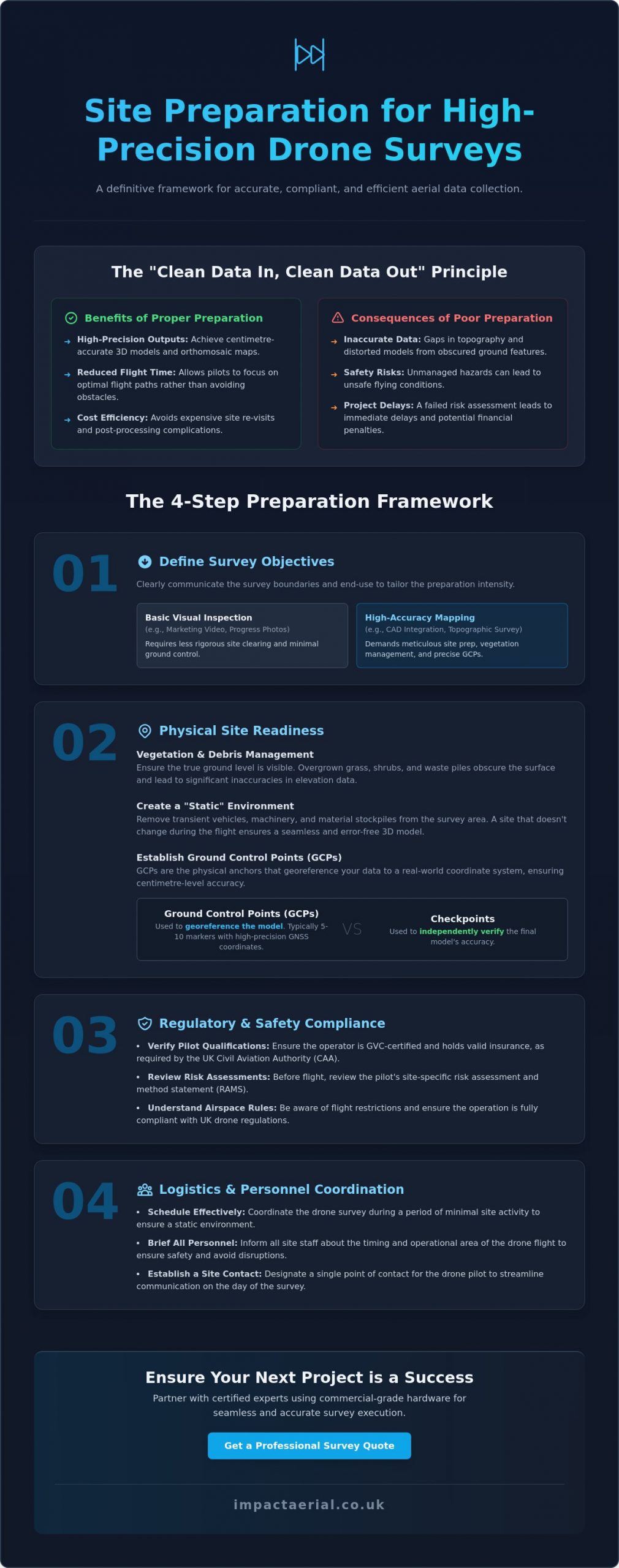
Site preparation isn’t just a preliminary chore; it’s the technical foundation of every successful drone survey. If you want high-precision outputs, you have to adopt the “Clean Data In, Clean Data Out” mindset. This process involves clearing physical obstacles and establishing precise data markers before the aircraft ever leaves the ground. Without this meticulous groundwork, the raw images captured will contain “noise” that compromises the integrity of your 3D models and orthomosaic maps.

Professional surveyors use the science of photogrammetry to turn these images into measurable data. If the site is cluttered or markers are obscured, the software struggles to align pixels accurately, leading to distorted results. Proper preparation ensures the digital twin of your site is a faithful, centimetre-accurate representation of reality.

To better understand this concept, watch this helpful video:

Meticulous preparation significantly reduces flight time. It ensures the pilot can focus on the flight path rather than dodging unexpected machinery or searching for hidden markers. More importantly, it avoids the high costs associated with site re-visits, which occur when data is found to be insufficient during post-production. It’s far more efficient to clear the site once than to pay for multiple mobilisations.

The Consequences of Inadequate Preparation

When ground features are obscured by overgrown vegetation or debris, it creates significant gaps in topographic data. The drone cannot see through solid objects; if it can’t see the ground, it can’t measure it accurately. Beyond data quality, unmanaged hazards pose serious safety risks. If a pilot identifies uncoordinated site activity or physical dangers during their risk assessment, they may deem the site unsafe. This leads to immediate project delays and potential financial penalties for lost operational windows.

Defining Your Survey Objectives

You must clearly communicate the exact survey boundaries to the pilot to ensure the flight plan covers every necessary square metre without missing critical edge data. Understanding how to prepare a site for a drone survey also depends on whether you need a basic visual inspection or high-accuracy mapping. A marketing video requires different prep than a survey intended for CAD integration. Your “End Use” dictates the intensity of the preparation; high-accuracy engineering projects require a far more rigorous setup of ground markers than a simple progress photo.

Physical Site Readiness: Ground Control and Surface Conditions

Achieving sub-centimetre precision requires more than just launching a drone; it demands a “static” and controlled environment. Understanding how to prepare a site for a drone survey starts with meticulous vegetation management. If you are commissioning a topographic survey, overgrown grass, thick shrubs, or piles of green waste will obscure the true ground level. This leads to significant inaccuracies in your digital terrain model. You should ensure that the ground surface is as visible as possible, particularly in areas where elevation changes are critical for your engineering data.

Lighting and timing are equally vital considerations for data quality. Deep shadows cast by buildings or large trees can hide essential details and confuse the photogrammetry software. While our pilots manage the specific flight windows to align with UK Civil Aviation Authority (CAA) regulations, your assistance in clearing transient vehicles and machinery creates a consistent dataset. A site that remains stationary during the flight ensures that the “stitching” process in post-production is seamless and error-free.

Ground Control Points (GCPs) vs. Checkpoints

GCPs are the physical anchors of your survey. These are markers placed on the ground with coordinates measured by a high-precision GNSS rover. For most commercial drone mapping projects, five to ten ground control points provide sufficient control to ensure global accuracy. You should use high-contrast markers, such as black and white “checkerboard” targets, which are easily identifiable from a flight altitude of 120 metres. While GCPs are used to “pin” the map to the earth, separate “checkpoints” are used by our team to independently verify the final accuracy of the model.

Managing Site Obstructions and Hazards

A successful mission requires a clear and secure Take-off and Landing Area (TOLA). This zone must be cordoned off from personnel and moving equipment to ensure a safe environment. You should also identify and communicate the presence of temporary hazards like cranes, scaffolding, or high-reach platforms that may not be present on satellite imagery. Clearing scattered debris is also helpful; loose materials can often be mistaken for permanent site features in complex 3D models. If you are unsure about specific site risks, our specialists can help you coordinate a drone survey plan that accounts for every physical variable on your premises.
How to Prepare a Site for a Drone Survey: A Professional UK Guide

Regulatory and Safety Compliance in the UK

A professional operation is built on a foundation of rigorous compliance. When considering how to prepare a site for a drone survey, your first administrative priority is verifying the credentials of your chosen operator. In the UK, professional pilots must hold a UK drone license, specifically the General Visual Line of Sight Certificate (GVC). This qualification demonstrates that the pilot has undergone formal theory and flight assessments and is authorized by the Civil Aviation Authority (CAA) to conduct complex commercial operations. You should always request a copy of their GVC and their current Operational Authorisation before work begins.

The technical preparation involves more than just checking a badge; it requires a comprehensive Pre-flight Information Bulletin (PFIB) and a site-specific risk assessment. These documents aren’t mere formalities. They outline the operational parameters, emergency procedures, and safety mitigations tailored to your specific environment. Our pilots consult the latest Civil Aviation Authority drone guidance (CAP 722) to ensure every flight path respects national airspace standards and safety protocols. Furthermore, high-risk commercial sites require substantial protection; we maintain £5m in commercial liability insurance to provide absolute peace of mind for our clients.

CAA Regulations and Site Access

The UK regulatory framework distinguishes between the “Open” and “Specific” categories of flight. Most commercial surveys on busy construction sites or industrial areas fall under the “Specific” category, which allows for flight closer to people and buildings than the basic regulations permit. You’ll need to assist the pilot by managing public rights of way and notifying neighbouring properties if the flight path overlaps their boundaries. It is a legal requirement that the CAA-certified pilot retains final authority on all safety matters; they have the right to pause or cancel a flight if the environment becomes unsafe.

Conducting a Pre-Flight Walkthrough

A joint walkthrough between the site manager and the UAV pilot is an essential step in your preparation. This physical inspection allows you to identify “No-Fly Zones” or sensitive infrastructure, such as nearby railway lines, high-voltage substations, or telecommunications towers, which may cause electromagnetic interference. During this time, the pilot will perform a final check of the Remote ID broadcast and local NOTAMs (Notices to Airmen) to ensure no temporary flight restrictions have been issued for the area. This collaborative approach ensures that the flight is both legally compliant and operationally efficient.

Logistics and Personnel: Coordinating Your Site Team

While physical ground prep and regulatory checks are essential, the success of an aerial mission often hinges on the human element. Mastering how to prepare a site for a drone survey requires a structured approach to internal communication. You must brief all site staff, subcontractors, and visiting stakeholders on the specific flight schedule well in advance. This avoids the “spectator effect” and ensures that ground-level work continues safely without personnel inadvertently wandering into active flight zones or take-off areas.

Establishing a secure “Staging Area” is a non-negotiable requirement for professional operations. This zone serves as the pilot’s command centre, where equipment is calibrated and batteries are managed. It must be cordoned off from heavy machinery and foot traffic to prevent accidental damage or interference. By providing a dedicated, quiet space for the survey team, you allow the pilot to focus entirely on the technical execution of the flight and the integrity of the data being captured.

Internal Communication and Staff Safety

Issuing a “Site-Wide Alert” via email or during the morning toolbox talk is the most effective way to manage expectations. This alert should clearly define the duration of the survey and the specific areas where the drone will be operating. It’s vital to remind personnel to stay clear of the Take-off and Landing Area (TOLA) during active rotors-turning periods. Additionally, site managers should be prepared to manage curious visitors or delivery drivers; a drone can be a significant distraction, and maintaining site focus is paramount for overall safety compliance.

Site Access and Logistics

Logistical delays are easily avoided with a bit of foresight. You should ensure the pilot has all necessary gate access codes and security clearances before they arrive at the perimeter. Providing high-resolution site maps or CAD overlays in advance allows our team to integrate your site’s specific geometry into the flight software. On-site, the survey vehicle needs safe parking as close to the take-off point as possible to facilitate equipment swaps. If the survey is extensive, confirming access to a 240v power source for battery charging or mobile base stations will ensure the team maintains a high operational tempo throughout the day.

Appointing a dedicated site liaison to work alongside the pilot is highly recommended. This individual can provide real-time updates on moving hazards, such as crane movements or concrete pours, which might not be visible from the pilot’s perspective. This level of coordination is what separates a basic flight from a professional, high-precision survey operation. To ensure your next project is managed with this level of meticulous care, contact us to discuss our construction site monitoring services.

Partnering with Impact Aerial for Seamless Survey Execution

While understanding how to prepare a site for a drone survey is a critical responsibility for any site manager, the ultimate success of the data collection rests on the technical proficiency of your aerial partner. Impact Aerial bridges the gap between raw physical preparation and high-tier engineering outputs. We utilise commercial-grade DJI Enterprise drones, which are specifically engineered for superior data density and stability in challenging UK environments. These aircraft allow us to capture high-resolution imagery that forms the basis of centimetre-accurate digital twins.

Our operational framework is built on a foundation of safety and compliance. Every pilot at Impact Aerial is CAA GVC certified; this qualification is essential for navigating the complex regulatory requirements of active construction sites and industrial facilities. We manage every aspect of the project lifecycle, from the initial pre-flight risk assessment to the final delivery of processed data. This end-to-end management ensures that you don’t have to worry about the intricacies of aviation law or hardware maintenance. We offer an unparalleled level of security for our clients by maintaining £5m in commercial liability insurance, ensuring that every stakeholder on your site is fully protected.

Our Technology and Expertise

We leverage the latest advancements in aerial technology to deliver actionable insights. By using a specialised survey drone equipped with 4K HDR cameras and high-precision sensors, we capture the fine details required for professional-grade analysis. Our expertise extends beyond the flight; our post-production team processes raw aerial data into sophisticated 3D models, topographic maps, and orthomosaics. This multi-sector experience includes:

  • Construction Site Monitoring: Tracking progress and identifying logistical bottlenecks in real-time.
  • PV Solar Farm Thermal Surveys: Detecting cell defects and equipment inefficiencies with thermal imaging.
  • Commercial Property Surveys: Providing high-resolution roof and facade inspections without the need for scaffolding.

Get Started with Your Professional Drone Survey

Choosing a professional drone service ensures that your site preparation efforts result in high-precision, usable data rather than just simple imagery. We understand the nuances of how to prepare a site for a drone survey and are ready to guide you through the administrative and physical requirements to ensure a successful mission. Our team is available to provide pre-survey consultations, helping you define your objectives and verify that your site is fully compliant before we mobilise.

Precision and safety are the core of our business. If you are ready to elevate your site data with professional aerial surveys, book your site assessment with Impact Aerial today.

Elevating Your Site Data with Professional Precision

A successful aerial mission is built on the rigorous groundwork established before the rotors even spin. By focusing on physical site readiness, ensuring strict CAA regulatory compliance, and maintaining clear internal communication, you eliminate the risks of data noise and operational delays. Mastering how to prepare a site for a drone survey transforms what could be a complex technical hurdle into a high-precision data asset for your project. This structured approach ensures that every flight is safe, efficient, and capable of producing the sub-centimetre accuracy your engineering or construction goals require.

Impact Aerial provides the technical expertise and operational security required for the most demanding UK sites. Based in the West Midlands and offering full UK coverage, our team utilizes a DJI Enterprise fleet and CAA GVC certified pilots to deliver superior data density. We provide total peace of mind through our £5m commercial liability insurance and end-to-end project management. Whether you require construction monitoring or a detailed topographic map, we ensure your data is accurate, compliant, and delivered on schedule.

Ready to capture high-precision insights for your next project? Request a Quote for Your Professional Drone Survey today and let our specialists manage the complexities of the airspace while you focus on your site’s success.

Frequently Asked Questions

Do I need to clear the entire site for a drone survey?

You don’t need to clear the entire premises, but you must ensure that the specific areas required for data collection are free from obstructions. For topographic mapping, the ground surface must be visible, so clearing overgrown vegetation and parked machinery in those zones is essential. If the survey is for a visual inspection of a roof or facade, clearing the ground level directly beneath the flight path is the priority to maintain safety cordons.

How long does a typical site preparation take?

Physical preparation usually takes a few hours to a full day, depending on the site’s complexity and size. Administrative tasks, such as securing permissions and notifying neighbours, should begin at least five working days before the flight. When planning how to prepare a site for a drone survey, it is best to complete debris removal and vegetation management forty-eight hours in advance to ensure the pilot has a clear environment upon arrival.

What happens if the weather is poor on the day of the survey?

The pilot makes a final “go or no-go” decision based on real-time weather data and safety parameters. High winds, typically exceeding 20mph, or any form of precipitation will usually result in a rescheduled flight to protect the equipment and ensure data integrity. We monitor forecasts closely in the forty-eight hours leading up to the mission to provide as much notice as possible if a delay is necessary due to adverse conditions.

Do I need to notify the police or CAA before the survey?

No, the responsibility for aviation notifications rests entirely with the drone operator. Professional pilots use specialized software to check for local flight restrictions and NOTAMs (Notices to Airmen) before every mission. If your site is located within an airport’s Flight Restriction Zone (FRZ), our team will coordinate directly with Air Traffic Control to secure the necessary flight permits and maintain legal compliance throughout the operation.

Can a drone survey be done while my staff are still working?

Yes, drone surveys are designed to minimize disruption, and work can usually continue as long as staff remain clear of the cordoned take-off and landing area. It is vital that all personnel are briefed on the flight schedule and understand the importance of staying outside the designated safety zones. Our pilots perform site-specific risk assessments to ensure that the flight path avoids active work areas where personnel density is highest.

What is the difference between a GCP and a checkpoint?

A Ground Control Point (GCP) is a marker used during the initial processing to “pin” the drone’s data to precise geographic coordinates. In contrast, a checkpoint is an independent marker used after the model is created to verify its accuracy. While GCPs build the map, checkpoints provide the mathematical proof that the survey meets the required precision standards. Using both ensures the highest level of data reliability for your project.

How much space does the pilot need for a take-off and landing area?

A clear, flat area of approximately 5m x 5m is generally sufficient for most DJI Enterprise drones used in commercial surveys. This Take-off and Landing Area (TOLA) must be free from overhead obstructions like power lines or tree branches and situated away from magnetic interference sources like large metal structures. The zone must be easily securable to prevent unauthorized personnel or vehicles from entering during the critical launch and recovery phases.

Is it necessary to have a site representative present during the flight?

It is highly recommended to have a dedicated site liaison available to assist the pilot with ground-level logistics. This representative manages personnel movements and provides the pilot with immediate updates on changing site hazards, such as crane activity or vehicle arrivals. Having a knowledgeable person on hand ensures the flight remains efficient and allows the pilot to focus entirely on the technical execution of the data capture.
How Accurate Are Drone Land Surveys? A Professional Guide for 2026

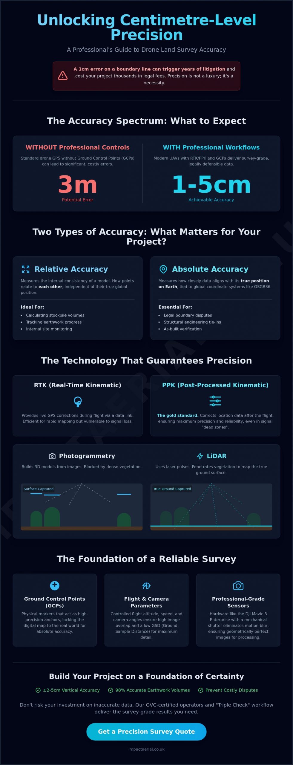
A single centimetre of error on a boundary line can trigger years of litigation and cost your development project thousands in legal fees. If you’re questioning how accurate are drone land surveys compared to traditional methods, you’re not alone. Many site managers feel the pressure to reduce survey costs but fear that switching to UAV technology might lead to data gaps or boundary disputes. You need to know that the data you’re using for a multi-million pound project meets the highest professional standards without the confusion of technical jargon like RTK and PPK.

Choosing the right sensor depends entirely on your terrain and required output. While photogrammetry is cost-effective for open sites and volume calculations, LiDAR is necessary for “bare-earth” models in wooded areas. By matching the sensor to the environment, we maintain the strict RICS-level standards expected in modern UK construction, and you can explore Drone Topographical Land Surveys options to find the ideal solution for complex site topographies.

This guide provides a professional look at the precise tolerances of modern UAV surveying and how to achieve centimetre-level accuracy for your UK construction or property project. We’ll explain how drone LiDAR systems in 2026 achieve a vertical accuracy of ±2-5 cm and why skipping ground control points can lead to errors of up to three metres. You’ll gain a clear understanding of the cost-to-accuracy trade-off and the confidence to hire GVC-certified operators who adhere to strict safety and regulatory protocols. We’ll also preview how automated feature extraction and 98% accurate earthwork volumes are transforming the industry standard for professional site monitoring.

Key Takeaways

  • Distinguish between relative accuracy for internal measurements and absolute accuracy for legal boundaries to prevent costly site disputes.
  • Evaluate the technical benefits of RTK and PPK workflows to maintain high-precision data even in areas with challenging signal coverage.
  • Understand how accurate are drone land surveys by comparing traditional methods against high-density point clouds that achieve 20mm horizontal tolerances.
  • Learn how flight altitude, camera angles, and the strategic use of Ground Control Points act as the foundation for reliable 3D site reconstruction.
  • Gain confidence in your survey data by adopting a “Triple Check” workflow that combines RTK technology with independent checkpoints and professional-grade sensors.

Defining Accuracy: Absolute vs. Relative Drone Data

Understanding how accurate are drone land surveys begins with a fundamental distinction between two types of measurement. In the professional surveying sector, we don’t treat “accuracy” as a generic term. By 2026, the industry standard for high-tier UAV data collection has reached a 1-3cm horizontal tolerance. This precision is achieved through a meticulous unmanned aerial photogrammetric survey workflow. Central to this is the Ground Sampling Distance (GSD), which represents the actual distance between two consecutive pixel centres on the ground. A smaller GSD means higher spatial resolution, allowing our team to identify smaller features with greater reliability. For example, a GSD of 1cm per pixel provides significantly more detail than a 5cm GSD, directly impacting the precision of the final digital twin.

What is Relative Accuracy?

Relative accuracy refers to the internal consistency of the 3D model or point cloud. It measures how points on the map relate to each other rather than their true position on the planet. If you’re managing a project focused on Construction Site Monitoring, relative accuracy is often your primary concern. It allows for highly precise calculations of stockpile volumes and site progress tracking. Photogrammetry software maintains this internal scale by stitching thousands of overlapping images together. While the entire map might be shifted a few metres from its true global position if uncorrected, every measurement within that map remains consistent. This is why relative data is sufficient for calculating the percentage of earth moved, even if the absolute GPS coordinates aren’t perfectly pinned.

The Importance of Absolute Accuracy

Absolute accuracy describes how closely the digital data aligns with its true position on the Earth’s surface. For UK property projects, this means linking drone data to global coordinate systems like OSGB36. This level of precision is non-negotiable when dealing with legal boundary disputes or structural ties. Achieving high absolute accuracy requires more than just high-end hardware; it demands a robust “verify” step. We use independent check-points, which are physical markers with known coordinates, to validate the final survey. This ensures the digital representation matches the physical world within centimetre-level tolerances. Without this verification, even the most visually impressive 3D model remains a “floating” map that lacks the legal or engineering weight required for professional certification.

The Tech Stack: RTK, PPK, and Sensor Selection

Precision isn’t just about the skill of the pilot; it’s about the integration of hardware and software. Modern UAV accuracy relies on a sophisticated tech stack that corrects satellite signals either in real time or during post-processing. When clients ask how accurate are drone land surveys in 2026, they’re often looking for assurance that the data can be trusted for multi-million pound developments. The industry has largely moved toward DJI Enterprise hardware, such as the Mavic 3 Enterprise, which features a mechanical shutter to eliminate motion blur. This hardware shift ensures that every pixel in a 4K HDR map is sharp and geometrically correct, providing the foundation for centimetre-level results.

RTK vs. PPK: Which Workflow Wins?

RTK (Real-Time Kinematic) provides live corrections to the drone’s position via a constant data link with a base station or network. It’s an efficient choice for rapid site mapping where immediate data verification is helpful. However, this connection can be fragile in remote UK locations or near high-rise urban structures where signal blockages occur. PPK (Post-Processed Kinematic) is the gold standard for these challenging environments. PPK is the process of correcting location data after the flight for maximum precision. The FHWA Tech Brief on sUAS for Land Surveying highlights how these workflows significantly outperform standard GPS, with PPK offering superior reliability in “dead zones” by removing the risk of mid-flight signal loss.

LiDAR: Penetrating Vegetation for Ground Accuracy

Photogrammetry relies on “seeing” a point from multiple angles to calculate its height. If a site is covered in dense woodland or thick scrub, photogrammetry only records the top of the vegetation. LiDAR (Light Detection and Ranging) is the essential tool for mapping the true ground surface on overgrown brownfield sites. It emits thousands of laser pulses per second that can travel through small gaps in the tree canopy to hit the earth below. This allows us to achieve vertical accuracy of ±2-5 cm even in areas where traditional cameras fail. If you’re planning a project on complex terrain, our Drone Commercial Property Surveys leverage this exact tech stack to ensure your data is boardroom-ready and engineering-grade.

Choosing the right sensor depends entirely on your terrain and required output. While photogrammetry is cost-effective for open sites and volume calculations, LiDAR is necessary for “bare-earth” models in wooded areas. By matching the sensor to the environment, we maintain the strict RICS-level standards expected in modern UK construction.

How Accurate Are Drone Land Surveys? A Professional Guide for 2026

Human and Environmental Factors Affecting Precision

While hardware determines the potential for precision, human and environmental variables dictate the actual outcome of every flight. When assessing how accurate are drone land surveys, we must look beyond the spec sheet of the UAV. Factors such as flight altitude, camera angles, and the distribution of ground markers can either validate or compromise the entire dataset. In the UK, environmental conditions like shifting light in Birmingham or sudden wind gusts can introduce sensor noise, making the role of a trained operator critical for data integrity. A professional workflow accounts for these variables before the propellers even start spinning, ensuring that the “digital twin” matches reality within millimetres.

Ground Control Points: The Anchor of Accuracy

Physical markers placed on-site, known as Ground Control Points (GCPs), serve as the definitive link between digital pixels and the physical earth. These markers are measured using traditional surveying equipment to establish a “truth” that the drone data must align with. For large-scale Construction Site Monitoring, the strategic distribution of GCPs is essential to prevent “bowl effects” or warping in the final 3D model. Even with advanced telemetry, GCPs act as a vital fail-safe against RTK signal drift or satellite geometry errors. Industry discussions on Accuracy in Drone Mapping often highlight that omitting these anchors can result in absolute errors of up to three metres, which is unacceptable for boundary-critical property projects. By “pinning” the map to these known coordinates, we ensure the survey remains georeferenced to the highest professional standards.

The Pilot’s Influence on Data Quality

The technical skill of the operator is the final layer of quality control. Achieving the 70-80% image overlap “sweet spot” is necessary for photogrammetry software to reconstruct 3D surfaces without warping or digital artifacts. A professional pilot also manages shutter speed to eliminate motion blur, a common issue when flying high-resolution DJI sensors in low-light UK winters. This level of meticulous planning is why CAA GVC certification is a mandatory requirement for our team. It ensures that the person behind the controls understands not just the flight physics, but the complex risk assessments and data-centric processes required to deliver RICS-standard results. Unlike prosumer operators, a certified professional can adjust flight paths from nadir (straight down) to oblique angles to capture the vertical faces of structures, significantly improving the depth and precision of the final 3D reconstruction.

By managing these human and environmental factors, we mitigate the risks that lead to data rejection. Whether it’s accounting for the specific wind resistance of a UAV or ensuring lighting conditions don’t wash out ground features, a meticulous approach is what separates a visual snapshot from a true survey-grade deliverable.

Drone Surveys vs. Traditional Methods: An Accuracy Comparison

Traditional land surveying relies on a total station to capture discrete points. While each point is highly precise, the spaces between them are often interpolated. This can lead to missed topographical nuances. When evaluating how accurate are drone land surveys, we must consider the density of the information. A drone captures millions of points across a site. This creates a high-density point cloud that reflects the actual contours of the land rather than an estimation. This density allows for 20mm horizontal tolerances while reducing field time by up to 70%. It also eliminates the need for surveyors to traverse hazardous slopes or unstable ground. This significantly improves site safety protocols.

Many complex projects now adopt a hybrid approach. We use drones for comprehensive site-wide data. We then rely on traditional total stations only for specific, high-precision “pins” or critical structural markers. This combination ensures the project benefits from both speed and micro-precision.

When Traditional Surveys Still Lead

There are specific scenarios where traditional methods remain the primary choice. If your project requires sub-5mm structural monitoring for sensitive heritage buildings, a total station offers a level of micro-precision that aerial sensors cannot currently match. Traditional methods are also essential for internal building surveys where GPS signals are blocked. If you need immediate, physical “hard-staked” boundary markers driven into the ground, a ground-based surveyor is necessary to perform the physical layout.

Why Drone Data is Often ‘Better’ for Large Sites

For large-scale developments, the visual context provided by an orthomosaic photo is superior to a standard CAD line drawing. A traditional survey might miss a small site error or a subtle depression. This happens because the surveyor didn’t happen to place their prism on that exact spot. Drone data captures everything. This provides a “complete” record of the site that is invaluable for Construction Site Monitoring. You can find more details on these methodologies in our complete guide to drone surveys.

If you’re ready to upgrade your data collection process, contact us to discuss our Drone Commercial Property Surveys and how we can integrate high-density mapping into your next project.

Guaranteeing Accuracy: The Impact Aerial Standard

Guaranteeing the precision of aerial data requires more than just high-end sensors; it demands a structured operational framework. We eliminate the guesswork surrounding how accurate are drone land surveys by employing a rigorous “Triple Check” workflow. This methodology integrates Real-Time Kinematic (RTK) corrections with physical Ground Control Points (GCPs) and independent check points. While the drone captures data, these independent markers verify the results, ensuring that the final output meets the centimetre-level tolerances required for modern engineering. We utilise DJI Enterprise hardware equipped with high-resolution 4K HDR sensors to capture every site detail with absolute clarity, supporting our commitment to technical excellence and data reliability.

Our operations are built on a foundation of compliance and risk mitigation. Every project is managed by CAA GVC certified pilots who maintain a deep understanding of current aviation regulations and safety protocols. To provide further reassurance to our clients, we carry £5m in public liability insurance, specifically tailored for commercial UAV operations. This professional rigour extends from the initial flight planning through to our sophisticated post-production pipeline, ensuring that the data we collect is not only accurate but also legally and operationally defensible for your project stakeholders.

Professional Data Delivery

We understand that raw data is only valuable if it integrates seamlessly with your existing software workflows. Our team provides deliverables in industry-standard formats, including AutoCAD, BIM, Point Clouds, and Digital Twin models. For West Midlands construction firms, this means high-accuracy data that can be imported directly into project management systems without conversion errors. Every survey we deliver includes a detailed accuracy report, providing transparent verification of the horizontal and vertical tolerances achieved during the mission. This documentation is essential for quality assurance and provides a clear audit trail for your Construction Site Monitoring or property survey needs.

Ready to Start Your Survey?

Choosing the right partner for your data collection is a critical decision for your project’s timeline and budget. We offer our regional expertise to businesses across Birmingham and the West Midlands, ensuring that local site conditions and specific regulatory requirements are always met. If you’re ready to discuss your specific accuracy needs or require a technical consultation for an upcoming project, our team is available to provide expert guidance. You can Request a professional drone survey quote today to see how our precision-driven approach can benefit your next development.

Securing Precision for Your 2026 Development Projects

The transition from traditional methods to UAV technology offers undeniable advantages in speed and data density. We’ve explored how the integration of RTK technology and Ground Control Points eliminates the uncertainty around how accurate are drone land surveys. By shifting from sparse traditional data to high-density point clouds, you gain a comprehensive digital record that protects against boundary disputes and costly site errors. This meticulous approach ensures that every deliverable meets the high standards required for engineering and legal purposes across the UK.

Reliability is guaranteed through our use of DJI Enterprise grade hardware and the professional oversight of CAA GVC certified pilots. Our team maintains £5m commercial liability insurance to provide maximum security for your site operations, ensuring you’re in expert hands from the first flight to the final data delivery. Whether you’re managing a large construction site or a complex property boundary, our structured workflow provides the psychological comfort and tangible benefits your business deserves. Book Your Precision Drone Survey Quote Today to receive an engineering-grade accuracy report for your next project. We look forward to helping you achieve centimetre-level precision with total confidence.

Frequently Asked Questions

Are drone surveys as accurate as traditional land surveys?

Drone surveys match traditional accuracy for topographical and volumetric requirements while providing a more complete site overview. While total stations remain the choice for sub-5mm structural pins, professional UAV systems achieve 20mm horizontal tolerances. This level of precision is sufficient for the vast majority of UK construction and property projects. The high density of data points often makes drone results more reliable for large-scale topographical mapping.

What is the typical margin of error for a professional drone survey?

When using professional hardware and ground control, the typical margin of error is ±1-3cm horizontally and ±2-5cm vertically. This is a significant improvement over uncorrected GPS data, which can be off by several metres. Achieving these tight tolerances depends on the ground sampling distance and the integration of RTK or PPK correction technology. When clients ask how accurate are drone land surveys, these centimetre-level figures are the professional benchmark.

Do I need Ground Control Points (GCPs) if my drone has RTK?

You should still use GCPs as independent checkpoints even with an RTK-enabled drone. While RTK provides real-time corrections to the aircraft’s position, GCPs act as a vital “truth” to verify the absolute accuracy of the digital model. This redundant workflow ensures the data remains georeferenced correctly. It also protects against potential satellite signal drift or telemetry errors during the flight, maintaining the integrity of the final survey.

Can drones survey accurately in high wind or rain?

High wind and rain negatively impact both data quality and operational safety. Wind speeds exceeding 20mph can cause sensor vibration and motion blur, while rain interferes with the optical clarity of the camera or LiDAR pulses. We strictly adhere to safety protocols and only fly during stable weather conditions. This ensures that the sensor noise is minimised and the integrity of the survey data remains uncompromised for professional use.

How does vegetation affect the accuracy of drone land surveys?

Dense vegetation presents a challenge for standard photogrammetry, as the camera cannot see the ground through the canopy. In these scenarios, we use LiDAR sensors that emit laser pulses to penetrate small gaps in the foliage. This technology allows us to map the true “bare-earth” surface with high precision on wooded or overgrown sites. It prevents the vertical errors that occur when a traditional camera only records the top of the treetops.

What file formats are drone survey results usually delivered in?

Deliverables are provided in industry-standard formats to ensure seamless integration with your existing software. Common outputs include .DWG for AutoCAD, .LAS or .LAZ for point clouds, and high-resolution GeoTIFFs for orthomosaic maps. We also provide BIM-compatible files and Digital Twin models. These formats support the specific needs of West Midlands construction teams and property managers who require how accurate are drone land surveys to be reflected in their CAD environments.

Does a drone survey meet RICS standards for land measurement?

Professional drone surveys can meet RICS-level standards when conducted by certified operators using survey-grade equipment. The high point density and centimetre-level accuracy of modern UAV data collection align with the professional requirements for land measurement and topographical mapping. We provide a detailed accuracy report with every survey. This documentation verifies that the rigorous standards expected by surveyors and engineers have been successfully achieved on-site.

How long does it take to process drone data into an accurate map?

Processing times typically range from 24 to 72 hours depending on the site size and data complexity. Large-scale projects involving millions of LiDAR points or thousands of high-resolution images require significant computing power to generate a precise 3D model. Our post-production pipeline ensures that every dataset undergoes rigorous quality checks. This ensures the final deliverables are accurate and boardroom-ready before they are handed over to the client.

Avoiding Common Drone Survey Mistakes: A Guide to Professional Data Collection

A Tier 1 contractor in Birmingham recently discovered that a single missed setting in their photogrammetry software rendered a £4,500 site survey completely unusable for planning. It’s a frustrating reality for many firms. While drones are transformative tools, the technical precision required means that even small oversights lead to significant project delays. You likely understand that accuracy is non-negotiable for site planning, yet the complexities of avoiding common drone survey mistakes can feel like a moving target.

This guide ensures your next flight delivers the professional results your clients expect by providing a roadmap to precision data collection. You’ll learn how to navigate UK Civil Aviation Authority (CAA) regulations and account for unpredictable British weather patterns that cause roughly 22% of all mission cancellations. We’ll break down the essential steps for capturing high-resolution, georeferenced data that keeps your projects on schedule and within budget.

Key Takeaways

  • Understand the critical importance of CAA regulations and commercial liability insurance to protect your business from the significant risks of non-compliant flight operations.
  • Master the technical distinction between relative and absolute accuracy, ensuring your data aligns perfectly through the strategic use of Ground Control Points (GCPs).
  • Learn how to mitigate the impact of unpredictable British weather and suboptimal lighting, a vital step in avoiding common drone survey mistakes that degrade sensor performance.
  • Adopt professional post-processing standards and rigorous data organisation techniques to prevent the “garbage in, garbage out” cycle that often stalls complex survey projects.
  • Evaluate the hidden financial risks of DIY drone operations and why partnering with a professional service provides the technical expertise required for high-quality, actionable data.

Regulatory and Planning Mistakes: More Than Just Flying

Successful data collection begins long before the drone leaves the ground. Many project managers assume that a pilot’s ability to manoeuvre a drone is the only metric that matters, but this oversight is a primary cause of project failure. Avoiding common drone survey mistakes requires a deep understanding of the Civil Aviation Authority (CAA) framework. Since the major regulatory overhaul in December 2020, the legal requirements for operating in UK airspace have become more stringent. Treating a survey as “just a quick flight” ignores the massive legal liability that follows a non-compliant operation.

To better understand how simple planning errors can derail a professional project, watch this helpful video:

Professional operators don’t just turn up and fly. They produce site-specific Risk Assessments and Method Statements (RAMS) that account for local hazards, nearby structures, and public safety. Without these documents, your site insurance is likely void. A meticulous pilot will also ensure their flight plan respects the principles of photogrammetry, as even slight deviations in altitude or overlap can render the entire dataset useless. Precision starts with planning, not just piloting.

The CAA GVC vs PfCO Confusion

The UK drone industry is currently transitioning from the old PfCO (Permission for Commercial Operation) to the GVC (General Visual Line of Sight Certificate). Many businesses mistakenly hire pilots with expired or irrelevant qualifications. You should always verify a pilot’s credentials by requesting their CAA Operator ID and flyer ID before they arrive on-site. Hiring an uncertified pilot isn’t just a safety risk; it’s a breach of health and safety protocols that can lead to five-figure fines for the hiring company.

Insurance Gaps and Liability

Standard public liability insurance rarely covers commercial drone operations. For added peace of mind, you must ensure your contractor holds specific commercial drone insurance that complies with EC 785/2004. In the UK construction and surveying sectors, a £5m liability cover is the industry standard. If an incident occurs and the pilot is found to be non-compliant with CAA regulations, the insurer will likely refuse the claim, leaving your business to shoulder the financial and legal fallout.

  • Verify Certification: Ensure the pilot holds a valid GVC or A2 CofC.
  • Check Insurance: Confirm the policy is specifically for commercial UAV operations.
  • Review RAMS: Don’t accept generic risk assessments; they must be site-specific.

Technical Accuracy Errors: Why Your Data Doesn’t Line Up

One of the most effective ways of avoiding common drone survey mistakes is understanding that high-quality visuals don’t always equate to high-quality data. Professional surveys require a clear distinction between relative and absolute accuracy. Relative accuracy ensures that the distance between two points on your map is correct; absolute accuracy ensures those points align perfectly with their real-world coordinates on the Earth’s surface. Relying solely on a drone’s internal GPS often leads to an absolute error margin of 3 to 5 metres, which is unacceptable for construction or boundary disputes.

Neglecting Ground Control Points (GCPs) remains a frequent pitfall for inexperienced operators. Even with advanced sensors, GCPs act as physical anchors that tie your digital model to the ground. Without at least five well-distributed GCPs per flight area, photogrammetry software lacks the necessary reference to correct “bowl effects” or scaling errors. Professionals also recognise the limitations of consumer-grade hardware. While a £1,000 hobbyist drone captures decent video, its rolling shutter creates “jello” distortion during movement. Commercial-grade platforms equipped with global shutters are essential for 99% of professional survey applications to ensure every pixel is captured simultaneously.

Incorrect camera settings frequently ruin datasets before the drone even lands. A shutter speed slower than 1/800th of a second introduces motion blur that prevents software from identifying tie points. Adhering to fundamental practices for drone remote sensing ensures that ISO remains low to prevent digital noise, which otherwise obscures fine details in 3D point clouds.

The Role of RTK and PPK Technology

Real-Time Kinematic (RTK) is a satellite navigation technique used to enhance the precision of position data derived from satellite-based positioning systems, providing centimetre-level accuracy in real-time. RTK is ideal for sites with strong telemetry links, while Post-Processed Kinematic (PPK) is superior for remote UK locations where signal dropouts are common. When setting up a drone survey, the most common base station error is failing to allow the unit to “soak” for at least 20 minutes to establish a stable position, leading to a shift in the entire dataset.

Flight Path and Overlap Issues

For high-quality 3D modelling, a minimum of 75% frontal overlap and 70% side overlap is non-negotiable. Reducing these values to save battery life is a false economy that results in “holes” in the final mesh. Most flight planning software uses a “mowing the lawn” grid pattern, but failing to account for wind resistance can cause the drone to tilt, altering the camera angle and skewing the Ground Sampling Distance (GSD). If your altitude fluctuates by even 5 metres, your GSD changes, meaning your resolution is no longer consistent across the site. For added peace of mind, hiring a CAA GVC certified specialist ensures these technical variables are managed with professional precision.

Environmental and Site Factors: Fighting the Elements

Operating in the United Kingdom presents a unique set of challenges for aerial data collection. Many operators fail because they don’t account for the subtle shifts in atmospheric conditions that compromise sensor accuracy. Successfully avoiding common drone survey mistakes requires a deep understanding of how the environment interacts with high-precision hardware. Professional data gathering isn’t just about the pilot’s skill; it’s about managing the unpredictable variables of the site itself.

Wind, Rain, and Sensor Integrity

Wind is the primary enemy of image sharpness. While a commercial drone might stay airborne in 25mph winds, gusts exceeding 15mph often introduce micro-vibrations. These vibrations result in motion blur that renders photogrammetry software unable to find tie points. We’ve seen projects where 40% of the data was discarded due to “light drizzle” flights. Unless a drone carries an IP45 rating or higher, moisture ingress will eventually lead to catastrophic mid-air failure. Temperature also dictates mission success. Below 5°C, LiPo battery chemical reactions slow down, reducing a standard 30-minute flight window to just 18 or 20 minutes. For added peace of mind, our team monitors local METAR reports before any deployment in Birmingham or the wider West Midlands.

Shadows and Contrast in Photogrammetry

It’s a common misconception that bright sunshine is ideal for surveying. Shooting at high noon creates harsh, vertical shadows that hide critical details in roof valleys or structural crevices. These “black holes” in the data prevent the software from generating a continuous point cloud. Overcast conditions provide diffused, even lighting that’s often superior for 3D modelling. To maintain high standards, we follow principles found in the USGS guidelines for UAS imagery to manage radiometric consistency. This is especially vital when surveying solar farms, where glare from panels can “blind” the sensor, creating 100% white pixels that contain zero usable data.

Magnetic interference is another silent project killer. Surveying near reinforced concrete, large steel structures, or 400kV power lines can confuse the drone’s internal compass. This leads to “toilet bowling” or erratic flight patterns. A professional survey must also account for site-specific obstructions like cranes or temporary scaffolding. Before we launch, we cross-reference the latest CAA NATS maps to ensure we aren’t infringing on restricted airspace or temporary “no-fly” zones. Overlooking these factors is a major hurdle in avoiding common drone survey mistakes and can lead to legal complications or compromised data sets.

Data Integrity and Post-Processing Blunders

Capturing high-resolution imagery is only half the battle. Professional data collection relies on the “garbage in, garbage out” principle; if the initial flight parameters or sensor calibrations are off, no amount of post-processing can fix the resulting inaccuracies. A critical part of avoiding common drone survey mistakes involves meticulous data management from the moment the SD card is removed from the aircraft.

Poor file naming and chaotic folder structures often lead to significant project friction. A 2023 industry report indicated that 14% of survey rework is caused by mislabelled data or lost files during transit. You should establish a consistent naming convention that includes the date, site location, and flight number. Establishing these protocols is a vital step in avoiding common drone survey mistakes that can cost a firm upwards of £1,500 in lost billable hours. Crucially, never leave a site without a verified backup. We recommend using a ruggedised field drive to mirror your data before you pack up your kit to ensure hardware failure doesn’t ruin your day.

  • Ensure output formats match client requirements, such as .LAS for point clouds or .DXF for CAD.
  • Verify coordinate systems, specifically OSGB36 for UK projects, to prevent alignment shifts.
  • Check for image gaps in the dataset before leaving the survey area.
  • Confirm all files are correctly indexed to avoid delays during the photogrammetry phase.

3D Modelling and Point Cloud Errors

Raw point clouds often contain “noise” from moving vehicles or vegetation. Failing to clean this data results in “ghosting” effects that compromise accuracy. Large-scale orthomosaics can suffer from stitching errors where images don’t align, creating visual breaks. To ensure compatibility with BIM software like Revit, you must verify decimation levels. Too much detail can crash a client’s system; too little renders the survey useless for engineering.

The Importance of Human Verification

Automated photogrammetry software isn’t a replacement for a trained eye. Software often struggles with vertical surfaces, causing “warping” on the sides of buildings. Spotting these anomalies requires a manual review of alignment logs. Using a professional survey drone expert in the editing suite ensures every centimetre is validated against Ground Control Points. This human-led approach separates a basic photo from a survey-grade asset.

Don’t let post-processing errors devalue your project data. Contact Impact Aerial today for professional drone survey services that guarantee precision and compliance.

Professional Drone Services vs DIY: Calculating the Real Cost

Many UK construction and surveying firms initially consider purchasing a consumer drone to handle inspections in-house. While a retail drone might only cost £1,200, the true operational cost of a DIY programme often exceeds £12,000 in the first year. This figure includes CAA GVC training, specialist photogrammetry software subscriptions, and high-tier commercial insurance. When you hire experts, you aren’t just paying for a pilot; you’re investing in a managed drone services workflow that covers everything from airspace clearing to complex data processing.

The financial logic of outsourcing rests on the ROI of precision. A single data error caused by an inexperienced internal pilot can lead to site delays costing upwards of £3,000 per day. Avoiding common drone survey mistakes means ensuring the data is actionable the moment it hits your desk. Professional operators provide a level of reliability that internal teams often struggle to match without years of flight experience. For added peace of mind, Impact Aerial carries £5 million in public liability insurance, protecting your project from the financial risks associated with site accidents or regulatory breaches.

Accessing Commercial-Grade Technology

Consumer drones like the DJI Mini series are excellent for photography but lack the hardware for professional surveying. These models use electronic shutters that cause “rolling shutter” distortion, ruining map accuracy at high speeds. Impact Aerial utilises the latest 4K HDR DJI Enterprise drones equipped with mechanical shutters and RTK (Real-Time Kinematic) modules. This technology delivers 2cm horizontal accuracy, something consumer models cannot achieve. Our fleet also supports thermal and multispectral sensors, allowing us to detect structural heat loss or moisture ingress that remains invisible to the naked eye.

Conclusion: Building a Robust Survey Strategy

Successfully avoiding common drone survey mistakes requires a commitment to quality over initial cost savings. Relying on outdated hardware or uncertified pilots puts your data and your reputation at risk. A robust strategy focuses on high-resolution outputs and strict adherence to CAA regulations. Use this final checklist when selecting your drone partner:

  • Verify their CAA GVC or PfCO certification status.
  • Confirm they use Enterprise-grade hardware with RTK capabilities.
  • Request proof of specific commercial drone liability insurance.
  • Check for a portfolio of similar surveying or inspection projects.
  • Ensure they can provide data in the specific formats your CAD or BIM software requires.

Don’t leave your site data to chance. Contact Impact Aerial for a professional consultation and ensure your next survey is delivered with centimetre-level precision and full regulatory compliance.

Secure Precision and Compliance for Your Next Survey

Achieving millimetre-accurate results isn’t just about owning a drone; it’s a matter of technical rigour and strict regulatory adherence. Avoiding common drone survey mistakes requires a deep understanding of how environmental variables and complex post-processing affect your final dataset. While DIY attempts might seem cheaper, they often result in costly data misalignment or legal risks that can stall a project for weeks. Professional services eliminate these variables, ensuring every flight delivers actionable, high-quality intelligence.

Impact Aerial brings expert-level certainty to your site. Our CAA GVC Certified Pilots operate a high-spec DJI Enterprise commercial fleet, capturing 4K HDR imagery that meets the most demanding industrial standards. For added peace of mind, we back our operations with £5m commercial liability insurance, protecting your assets and your reputation. We’re ready to help you navigate the complexities of modern aerial data collection with efficiency and precision. Your project deserves the reliability that only a vetted, professional operator can provide.

Request a Quote for Your Professional Drone Survey

Frequently Asked Questions

What is the most common mistake made during a drone survey?

Inadequate pre-flight planning and insufficient image overlap are the most frequent errors encountered in the field. Professional operators must maintain a minimum of 75% frontal and 60% side overlap to ensure the photogrammetry software can accurately stitch the data. Failing to account for these technical requirements is a primary factor in avoiding common drone survey mistakes during the initial data-gathering phase.

Do I need a special license to conduct a commercial drone survey in the UK?

You require a General Visual Line of Sight Certificate (GVC) issued by the Civil Aviation Authority (CAA) to operate drones commercially within the Specific Category. Since the regulatory transition in December 2020, professional pilots must also hold valid commercial liability insurance that complies with UK Regulation (EC) No 785/2004. This typically involves a minimum cover of £5 million to provide clients with total peace of mind during complex site operations.

How much accuracy can I expect from a professional drone survey?

A professional survey typically delivers a Ground Sampling Distance (GSD) of between 1cm and 3cm per pixel depending on flight altitude. When our team utilises high-specification sensors and Ground Control Points, you can achieve absolute global accuracy of 20mm to 50mm across the entire site. These precise figures are essential for topographical mapping where 95% of data points must fall within the specified project tolerances.

Can I use a standard DJI Mavic for a land survey?

A standard DJI Mavic lacks the mechanical shutter and RTK capabilities required for professional survey-grade precision. Consumer drones use electronic rolling shutters that cause “jello” distortion at high speeds, which can introduce spatial errors of 5 metres or more in 3D models. Professional land surveys demand enterprise-grade hardware like the DJI Matrice 350 RTK to ensure sub-centimetre data reliability and repeatable results.

What happens if a drone survey is conducted in poor lighting?

Poor lighting increases ISO noise and motion blur, which prevents photogrammetry software from identifying distinct tie points between images. Surveys conducted with less than 1,000 lux of ambient light often result in “noisy” point clouds and distorted digital twin reconstructions. Professional teams monitor solar noon and cloud cover to ensure a consistent 1/500th shutter speed for crisp, usable data collection.

Why are Ground Control Points (GCPs) so important?

Ground Control Points anchor your aerial data to real-world coordinates, ensuring the survey is geographically accurate rather than just internally consistent. Without at least 5 to 8 GCPs per flight area, a survey might suffer from a “bowl effect” or be displaced by several metres from its true location. Using these physical markers is a proven method for avoiding common drone survey mistakes related to global positioning and scaling.

How does wind speed affect drone survey data?

Wind speeds exceeding 15 knots significantly degrade battery life and gimbal stability, which often leads to blurred imagery and inconsistent data. High winds cause the aircraft to tilt aggressively to maintain its position, altering the camera angle and reducing the effective overlap of the flight path. Professional operators ground flights when gusts reach 20 knots to protect both the equipment and the integrity of the data.

What is the difference between RTK and standard GPS drones?

Real-Time Kinematic (RTK) drones provide centimetre-level positioning by constantly correcting satellite signals against a fixed base station or network. Standard GPS drones have a horizontal margin of error between 1.5 and 5 metres, which is unsuitable for high-precision engineering or construction projects. RTK technology reduces the number of physical ground markers needed while maintaining a 99.9% reliability rate for spatial coordinates.

Drone Survey Accuracy Standards: A UK Professional’s Guide

For UK professionals in construction, engineering, and land management, the question is no longer if drones can be used for surveying, but how to guarantee the data meets rigorous professional criteria. Navigating the complex world of drone survey accuracy standards is the critical first step, yet it’s an area often clouded by technical jargon and inconsistent operator claims. This uncertainty can lead to costly errors and project delays, leaving you unsure if your investment in aerial data is genuinely reliable.

This definitive guide is designed to provide clarity and peace of mind. We will demystify the essential metrics, from Ground Sample Distance (GSD) to Root Mean Square Error (RMSE), and explain the technologies like RTK and PPK that separate hobbyist results from professional, survey-grade data. By the end, you will understand the key standards and be equipped to confidently specify project requirements, choose a qualified CAA-certified operator, and make critical decisions based on precise and verifiable aerial intelligence.

Key Takeaways

  • Understand the critical difference between relative and absolute accuracy to correctly specify the data requirements for your project from the outset.
  • Learn how technologies like RTK, PPK, and Ground Control Points (GCPs) are the essential components for achieving verifiable, survey-grade precision.
  • Mastering key operational factors, from flight planning to weather conditions, is fundamental to meeting professional drone survey accuracy standards on every project.
  • Ensure your projects are compliant by aligning your drone survey outputs with established UK benchmarks, including guidance from RICS and PAS 128 specifications.

Foundations of Accuracy: Key Concepts in Drone Surveying

In a geospatial context, ‘accuracy’ is a precise, technical term. It moves beyond the subjective quality of a clear image to the objective, measurable precision of the data gathered. For project managers, understanding this distinction is crucial for evaluating the quality and reliability of a drone survey. It ensures that the final outputs-be they 3D models, topographical maps, or volume calculations-are not just visually impressive, but are built on a foundation of verifiable data. This section demystifies the core metrics and language that define professional drone survey accuracy standards.

To better understand these concepts in practice, the following video provides a clear overview of how survey accuracy is proven:

GSD (Ground Sampling Distance): The Building Block of Detail

Ground Sampling Distance is the real-world size represented by a single pixel in your aerial imagery. This value is determined by the drone’s flight altitude and the camera’s sensor and lens specifications. A lower GSD, such as 1cm, means each pixel covers a smaller area, resulting in a sharper, more detailed map. It is important to note that while GSD is fundamental to the resolution of your data and underpins the principles of photogrammetric surveys, it does not in itself guarantee positional accuracy.

Relative vs. Absolute Accuracy: The Critical Distinction

This is a critical concept in surveying. Relative accuracy means that measurements within the dataset are correct in relation to each other. For example, a survey could produce a perfectly proportioned floorplan of a building, with all wall lengths and angles correct. Absolute accuracy, however, means the entire dataset is correctly positioned on the Earth’s surface. Using our example, this would mean that the perfectly rendered floorplan is also placed in the correct location on a global coordinate system like the OS National Grid.

Understanding RMSE (Root Mean Square Error)

Root Mean Square Error is the industry-standard metric used to quantify the overall accuracy of a survey dataset. It represents the statistical difference between the coordinates of measured points and their ‘true’ known coordinates, established by ground control points. A lower RMSE value signifies higher accuracy. This is typically reported in three dimensions, giving you a clear, quantifiable measure of data quality:

  • X Error (Easting)
  • Y Error (Northing)
  • Z Error (Elevation)

The Technology Driving Survey-Grade Precision

Achieving centimetre-level accuracy with a drone survey is not accidental; it is the direct result of combining specialist hardware, meticulous flight planning, and robust data processing techniques. While a standard consumer drone can capture impressive images, it lacks the sophisticated systems required for survey-grade data gathering. To meet professional drone survey accuracy standards, operators utilise a suite of integrated technologies. These systems work in concert to elevate a drone from a simple aerial camera into a powerful geospatial tool, a principle detailed in the official Earth observation and aerial survey standards from the Royal Institution of Chartered Surveyors (RICS).

Photogrammetry vs. LiDAR: Choosing the Right Sensor

The primary data capture is performed by one of two sensor types. Photogrammetry is the science of creating highly detailed 3D models and maps from hundreds or thousands of overlapping 2D photographs. It is exceptionally effective for creating visually rich orthomosaic maps and digital surface models. In contrast, LiDAR (Light Detection and Ranging) uses a laser scanner to fire rapid pulses of light, directly measuring distances to create a point cloud. Its key advantage is the ability to penetrate vegetation, making it the superior choice for accurately mapping ground topography in wooded or overgrown areas.

RTK and PPK: The Game-Changers for GNSS Positioning

A drone’s standard GNSS (Global Navigation Satellite System, which includes GPS) receiver has an inherent positioning error of several metres. To correct this, professional survey drones are equipped with either RTK or PPK systems.

  • RTK (Real-Time Kinematic) uses a fixed ground base station to transmit live positioning corrections to the drone during flight, refining location data to within 1-2 centimetres.
  • PPK (Post-Processed Kinematic) records satellite and drone data separately, which is then corrected against base station data after the flight.

Both technologies dramatically improve positional accuracy and significantly reduce the number of Ground Control Points required on site.

Ground Control Points (GCPs) and Checkpoints: The Ultimate Verification

Even with RTK or PPK, physical ground-truthing is essential for guaranteeing absolute accuracy. Ground Control Points (GCPs) are clearly marked targets placed across the survey area with their precise coordinates measured by a survey-grade GNSS rover. This data is used during processing to anchor the entire drone dataset to the real world. In addition, Checkpoints-which are identical to GCPs but are not used in the initial processing-serve as an independent means of verifying the final accuracy of the model. A professional survey report will always detail the GCPs used and the final accuracy results measured against these independent checkpoints.

Factors That Influence Drone Survey Data Quality

Achieving centimetre-level accuracy with a drone survey is not an automated process; it is the result of meticulous planning and professional control over numerous variables. Understanding these factors helps clients appreciate the technical skill required to produce survey-grade data and allows for better project planning to meet stringent drone survey accuracy standards. A professional pilot actively manages these elements to ensure the final deliverables are reliable and precise.

Flight Planning and Execution

The foundation of any reliable survey is a comprehensive flight plan. This mission-critical phase dictates the quality of the raw data captured. Key considerations include:

  • Image Overlap: A high overlap, typically 70-80% both frontally and sideways, is crucial. This redundancy ensures photogrammetry software has sufficient common points between images to accurately reconstruct the 3D model.
  • Flight Altitude: This determines the Ground Sample Distance (GSD)-the real-world size of one pixel in an image. A lower altitude yields a smaller GSD and higher detail but takes longer to cover an area. We balance this to meet project specifications efficiently.
  • Flight Pattern: For flat, open land, a consistent grid pattern is effective. However, for complex sites with vertical structures or significant elevation changes, a crosshatch pattern (flying the grid twice, perpendicular to the first flight) is essential to minimise data gaps and building lean.

Throughout the flight, maintaining a consistent speed and fixed camera settings (aperture, ISO, shutter speed) is vital to prevent data inconsistencies that can compromise the final model.

Environmental and Site Conditions

A professional operator must assess and mitigate real-world site conditions. Weather is a primary concern; high winds can affect the drone’s stability and cause image blur, while poor or inconsistent light from fast-moving clouds can degrade image quality. Beyond the weather, site-specific features like dense vegetation can obscure the true ground level, while reflective surfaces such as water, glass, or wet asphalt can create errors and holes in the 3D data.

Equipment and Sensor Quality

The quality of the final data is fundamentally linked to the quality of the equipment. Consumer-grade drones are not built for the demands of professional surveying. For reliable and repeatable results that meet UK drone survey accuracy standards, professional-grade equipment is non-negotiable.

  • Professional Drones: Platforms must offer superior stability, flight endurance, and often RTK/PPK capabilities for centimetre-level georeferencing.
  • Camera Sensor: A larger sensor with a mechanical shutter produces far better results. Mechanical shutters prevent the ‘rolling shutter’ distortion common in consumer drones, which is critical for creating accurate orthomosaics and 3D models.
  • Regular Calibration: Ensuring the camera and Inertial Measurement Unit (IMU) are regularly calibrated is a core part of professional operations, guaranteeing the system performs as expected.

For added peace of mind, our CAA-certified pilots use state-of-the-art professional drones, selected by Impact Aerial, to ensure we capture the highest quality data for every project.

UK Industry Standards and Accuracy Benchmarks

While the principles of photogrammetry are universal, their application within the UK construction, engineering, and property sectors is governed by established professional frameworks. Understanding these UK-specific drone survey accuracy standards is crucial for ensuring that the data you receive is not just technically precise, but also legally compliant and fit for purpose within a professional context.

RICS Guidance on Aerial Surveying

The Royal Institution of Chartered Surveyors (RICS) provides an essential professional framework for survey data. Their guidance on aerial surveying using drones emphasises the importance of a clearly defined project specification, transparent methodology, and comprehensive accuracy reporting. RICS standards focus on ensuring the final deliverables are reliable and meet the client’s specific needs, positioning drone-captured data within the same rigorous context as traditional survey outputs.

Applying Accuracy Classes to Your Project

The required level of accuracy is dictated entirely by the project’s goals. A professional operator will tailor the data-gathering process to meet these specific benchmarks. Common examples include:

  • Topographic & As-Built Surveys: For site plans, design, and verification, an absolute accuracy of 2-5cm is the typical industry requirement. This demands the use of a robust GCP network.
  • Volumetric Calculations: When measuring stockpiles or earthworks, high relative accuracy is the priority. The focus is on ensuring the internal consistency of the 3D model to produce reliable volume reports, often to within 1-2% of traditional measurements.
  • Visual & Thermal Inspections: For asset condition reports, absolute positional accuracy is less critical than the Ground Sample Distance (GSD). A low GSD ensures high-resolution imagery where fine details like cracks or defects are clearly visible.

The Role of CAA Certification in Ensuring Quality

Technical skill must be paired with proven regulatory compliance. In the UK, any commercial drone operation is legally required to be conducted by a pilot holding a valid certification from the Civil Aviation Authority (CAA), such as the GVC (General VLOS Certificate). This certification is a non-negotiable standard that demonstrates a pilot’s operational competence, safety awareness, and understanding of UK airspace regulations. Working with a CAA-certified operator provides peace of mind that your survey is being conducted legally, safely, and professionally. To discuss how our fully certified services can meet your project’s accuracy needs, please contact our team of experts.

Partnering for Precision: Your Next Steps in Drone Surveying

Navigating the complexities of drone surveying in the UK requires a firm grasp of the principles that define data quality, from understanding Ground Sample Distance (GSD) to appreciating the transformative impact of RTK technology. Ultimately, adhering to professional drone survey accuracy standards is not merely a technical exercise; it is the fundamental requirement for delivering reliable, actionable data that project stakeholders can trust. The difference between acceptable and exceptional results lies in the combination of advanced equipment, meticulous planning, and certified operational expertise.

At Impact Aerial, we provide this exacting level of service for projects across the UK. Our CAA GVC Certified and fully insured pilots leverage professional DJI Enterprise drones with RTK capabilities, bringing extensive experience from demanding construction, property, and infrastructure sectors. Ensure your project’s success with verifiable, survey-grade data. Contact Impact Aerial for a consultation. Let us provide the precision and peace of mind your critical projects deserve.

Frequently Asked Questions About Drone Survey Accuracy

What is a realistic accuracy I can expect from a professional drone survey?

For a professionally executed drone survey utilising RTK/PPK technology and a robust network of Ground Control Points (GCPs), you can realistically expect accuracies in the range of 1-3cm horizontally and 2-5cm vertically. This level of precision is well within the tolerances required for most topographical mapping, construction progress monitoring, and volumetric calculation tasks. The final accuracy is always dependent on the project specification, equipment used, and the methodology applied by the certified drone operator.

Is a drone survey as accurate as traditional ground-based surveying methods?

Yes, for many applications, a high-quality drone survey can achieve accuracy comparable to traditional ground-based methods like GPS rovers or Total Stations. For large-scale topographical surveys, drone photogrammetry is often more efficient while delivering similar centimetre-level results. However, for specific high-precision tasks, such as establishing primary site control or deformation monitoring, traditional survey techniques remain the benchmark. The key is choosing the right tool for the specific project requirements.

If a drone has RTK/PPK, are Ground Control Points still necessary?

While RTK/PPK technology significantly improves the positional accuracy of the drone’s camera, we strongly advocate for the use of Ground Control Points (GCPs) as an essential quality assurance measure. GCPs provide an independent ground-truth reference that verifies the absolute accuracy of the final dataset. For projects where precision is critical and data must be defensible, using a combination of RTK/PPK and GCPs is the professional standard and ensures the highest level of confidence.

How can I verify the accuracy of the drone survey data I receive?

The most direct method is to review the comprehensive survey report provided by your drone services provider. This document should detail the Root Mean Square Error (RMSE) calculated from the Ground Control Points and independent Check Points. For added peace of mind, you can use a GPS rover to check the coordinates of several distinct features (e.g., manhole covers, building corners) on-site and compare them directly against the coordinates in the delivered 3D model or orthophoto.

What key information should be included in a drone survey accuracy report?

A professional accuracy report should be transparent and detailed, adhering to recognised drone survey accuracy standards. Key information must include the coordinate system used (e.g., OSGB36), the number and distribution of GCPs and Check Points, and a clear table showing the Root Mean Square Error (RMSE) for the X, Y, and Z axes. It should also contain a summary statement confirming the final achieved accuracy and its fitness for the intended purpose of the survey data.

Does the accuracy of a drone survey affect its cost?

Yes, the required level of accuracy is a significant factor in the overall cost of a drone survey. Achieving higher, centimetre-level accuracy necessitates more extensive fieldwork, including the placement and measurement of multiple Ground Control Points by a surveyor. It also requires more sophisticated RTK/PPK-enabled drones and longer data processing times. A survey for visual progress monitoring will cost considerably less than one required for precise as-built verification, with prices potentially varying by hundreds of pounds (£).

