A professional drone survey is won or lost on the ground before the rotors even spin. You likely recognize that high-precision aerial data is a game-changer for your project, yet the fear of receiving inaccurate results or falling foul of strict CAA regulations remains a significant hurdle. It’s frustrating to schedule a survey only to find that site access issues or ongoing work disruptions compromise the entire operation and lead to costly delays.
This guide provides a definitive framework on how to prepare a site for a drone survey, ensuring you master the physical and administrative requirements for a seamless, high-precision operation. By following these steps, you’ll gain the confidence that your site is ready for a safe, compliant mission. We will walk through essential ground control point placement, UK legal compliance under the 2026 standards, and strategies to maintain site productivity while GVC-certified pilots capture the technical data your business requires. Our goal is to provide a meticulously structured approach that ensures your data is accurate and your site remains fully operational throughout the process.
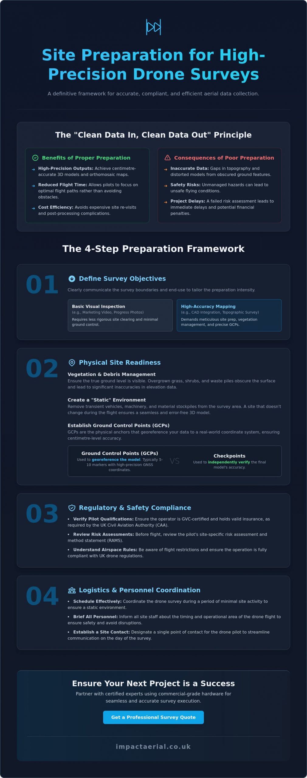
Key Takeaways
- Understand the “clean data in, clean data out” principle to ensure your survey results meet professional precision standards.
- Master the technical steps of how to prepare a site for a drone survey, including vegetation management and Ground Control Point (GCP) placement.
- Ensure full regulatory compliance by verifying pilot qualifications and reviewing site-specific risk assessments before operations begin.
- Coordinate site personnel effectively to maintain safety and productivity during the data collection process.
- Learn how commercial-grade hardware and GVC-certified expertise mitigate risks and deliver superior data density.
Why Site Preparation is Critical for Accurate Drone Data
Site preparation isn’t just a preliminary chore; it’s the technical foundation of every successful drone survey. If you want high-precision outputs, you have to adopt the “Clean Data In, Clean Data Out” mindset. This process involves clearing physical obstacles and establishing precise data markers before the aircraft ever leaves the ground. Without this meticulous groundwork, the raw images captured will contain “noise” that compromises the integrity of your 3D models and orthomosaic maps.
Professional surveyors use the science of photogrammetry to turn these images into measurable data. If the site is cluttered or markers are obscured, the software struggles to align pixels accurately, leading to distorted results. Proper preparation ensures the digital twin of your site is a faithful, centimetre-accurate representation of reality.
To better understand this concept, watch this helpful video:
Meticulous preparation significantly reduces flight time. It ensures the pilot can focus on the flight path rather than dodging unexpected machinery or searching for hidden markers. More importantly, it avoids the high costs associated with site re-visits, which occur when data is found to be insufficient during post-production. It’s far more efficient to clear the site once than to pay for multiple mobilisations.
The Consequences of Inadequate Preparation
When ground features are obscured by overgrown vegetation or debris, it creates significant gaps in topographic data. The drone cannot see through solid objects; if it can’t see the ground, it can’t measure it accurately. Beyond data quality, unmanaged hazards pose serious safety risks. If a pilot identifies uncoordinated site activity or physical dangers during their risk assessment, they may deem the site unsafe. This leads to immediate project delays and potential financial penalties for lost operational windows.
Defining Your Survey Objectives
You must clearly communicate the exact survey boundaries to the pilot to ensure the flight plan covers every necessary square metre without missing critical edge data. Understanding how to prepare a site for a drone survey also depends on whether you need a basic visual inspection or high-accuracy mapping. A marketing video requires different prep than a survey intended for CAD integration. Your “End Use” dictates the intensity of the preparation; high-accuracy engineering projects require a far more rigorous setup of ground markers than a simple progress photo.
Physical Site Readiness: Ground Control and Surface Conditions
Achieving sub-centimetre precision requires more than just launching a drone; it demands a “static” and controlled environment. Understanding how to prepare a site for a drone survey starts with meticulous vegetation management. If you are commissioning a topographic survey, overgrown grass, thick shrubs, or piles of green waste will obscure the true ground level. This leads to significant inaccuracies in your digital terrain model. You should ensure that the ground surface is as visible as possible, particularly in areas where elevation changes are critical for your engineering data.
Lighting and timing are equally vital considerations for data quality. Deep shadows cast by buildings or large trees can hide essential details and confuse the photogrammetry software. While our pilots manage the specific flight windows to align with UK Civil Aviation Authority (CAA) regulations, your assistance in clearing transient vehicles and machinery creates a consistent dataset. A site that remains stationary during the flight ensures that the “stitching” process in post-production is seamless and error-free.
Ground Control Points (GCPs) vs. Checkpoints
GCPs are the physical anchors of your survey. These are markers placed on the ground with coordinates measured by a high-precision GNSS rover. For most commercial drone mapping projects, five to ten ground control points provide sufficient control to ensure global accuracy. You should use high-contrast markers, such as black and white “checkerboard” targets, which are easily identifiable from a flight altitude of 120 metres. While GCPs are used to “pin” the map to the earth, separate “checkpoints” are used by our team to independently verify the final accuracy of the model.
Managing Site Obstructions and Hazards
A successful mission requires a clear and secure Take-off and Landing Area (TOLA). This zone must be cordoned off from personnel and moving equipment to ensure a safe environment. You should also identify and communicate the presence of temporary hazards like cranes, scaffolding, or high-reach platforms that may not be present on satellite imagery. Clearing scattered debris is also helpful; loose materials can often be mistaken for permanent site features in complex 3D models. If you are unsure about specific site risks, our specialists can help you coordinate a drone survey plan that accounts for every physical variable on your premises.
Regulatory and Safety Compliance in the UK
A professional operation is built on a foundation of rigorous compliance. When considering how to prepare a site for a drone survey, your first administrative priority is verifying the credentials of your chosen operator. In the UK, professional pilots must hold a UK drone license, specifically the General Visual Line of Sight Certificate (GVC). This qualification demonstrates that the pilot has undergone formal theory and flight assessments and is authorized by the Civil Aviation Authority (CAA) to conduct complex commercial operations. You should always request a copy of their GVC and their current Operational Authorisation before work begins.
The technical preparation involves more than just checking a badge; it requires a comprehensive Pre-flight Information Bulletin (PFIB) and a site-specific risk assessment. These documents aren’t mere formalities. They outline the operational parameters, emergency procedures, and safety mitigations tailored to your specific environment. Our pilots consult the latest Civil Aviation Authority drone guidance (CAP 722) to ensure every flight path respects national airspace standards and safety protocols. Furthermore, high-risk commercial sites require substantial protection; we maintain £5m in commercial liability insurance to provide absolute peace of mind for our clients.
CAA Regulations and Site Access
The UK regulatory framework distinguishes between the “Open” and “Specific” categories of flight. Most commercial surveys on busy construction sites or industrial areas fall under the “Specific” category, which allows for flight closer to people and buildings than the basic regulations permit. You’ll need to assist the pilot by managing public rights of way and notifying neighbouring properties if the flight path overlaps their boundaries. It is a legal requirement that the CAA-certified pilot retains final authority on all safety matters; they have the right to pause or cancel a flight if the environment becomes unsafe.
Conducting a Pre-Flight Walkthrough
A joint walkthrough between the site manager and the UAV pilot is an essential step in your preparation. This physical inspection allows you to identify “No-Fly Zones” or sensitive infrastructure, such as nearby railway lines, high-voltage substations, or telecommunications towers, which may cause electromagnetic interference. During this time, the pilot will perform a final check of the Remote ID broadcast and local NOTAMs (Notices to Airmen) to ensure no temporary flight restrictions have been issued for the area. This collaborative approach ensures that the flight is both legally compliant and operationally efficient.
Logistics and Personnel: Coordinating Your Site Team
While physical ground prep and regulatory checks are essential, the success of an aerial mission often hinges on the human element. Mastering how to prepare a site for a drone survey requires a structured approach to internal communication. You must brief all site staff, subcontractors, and visiting stakeholders on the specific flight schedule well in advance. This avoids the “spectator effect” and ensures that ground-level work continues safely without personnel inadvertently wandering into active flight zones or take-off areas.
Establishing a secure “Staging Area” is a non-negotiable requirement for professional operations. This zone serves as the pilot’s command centre, where equipment is calibrated and batteries are managed. It must be cordoned off from heavy machinery and foot traffic to prevent accidental damage or interference. By providing a dedicated, quiet space for the survey team, you allow the pilot to focus entirely on the technical execution of the flight and the integrity of the data being captured.
Internal Communication and Staff Safety
Issuing a “Site-Wide Alert” via email or during the morning toolbox talk is the most effective way to manage expectations. This alert should clearly define the duration of the survey and the specific areas where the drone will be operating. It’s vital to remind personnel to stay clear of the Take-off and Landing Area (TOLA) during active rotors-turning periods. Additionally, site managers should be prepared to manage curious visitors or delivery drivers; a drone can be a significant distraction, and maintaining site focus is paramount for overall safety compliance.
Site Access and Logistics
Logistical delays are easily avoided with a bit of foresight. You should ensure the pilot has all necessary gate access codes and security clearances before they arrive at the perimeter. Providing high-resolution site maps or CAD overlays in advance allows our team to integrate your site’s specific geometry into the flight software. On-site, the survey vehicle needs safe parking as close to the take-off point as possible to facilitate equipment swaps. If the survey is extensive, confirming access to a 240v power source for battery charging or mobile base stations will ensure the team maintains a high operational tempo throughout the day.
Appointing a dedicated site liaison to work alongside the pilot is highly recommended. This individual can provide real-time updates on moving hazards, such as crane movements or concrete pours, which might not be visible from the pilot’s perspective. This level of coordination is what separates a basic flight from a professional, high-precision survey operation. To ensure your next project is managed with this level of meticulous care, contact us to discuss our construction site monitoring services.
Partnering with Impact Aerial for Seamless Survey Execution
While understanding how to prepare a site for a drone survey is a critical responsibility for any site manager, the ultimate success of the data collection rests on the technical proficiency of your aerial partner. Impact Aerial bridges the gap between raw physical preparation and high-tier engineering outputs. We utilise commercial-grade DJI Enterprise drones, which are specifically engineered for superior data density and stability in challenging UK environments. These aircraft allow us to capture high-resolution imagery that forms the basis of centimetre-accurate digital twins.
Our operational framework is built on a foundation of safety and compliance. Every pilot at Impact Aerial is CAA GVC certified; this qualification is essential for navigating the complex regulatory requirements of active construction sites and industrial facilities. We manage every aspect of the project lifecycle, from the initial pre-flight risk assessment to the final delivery of processed data. This end-to-end management ensures that you don’t have to worry about the intricacies of aviation law or hardware maintenance. We offer an unparalleled level of security for our clients by maintaining £5m in commercial liability insurance, ensuring that every stakeholder on your site is fully protected.
Our Technology and Expertise
We leverage the latest advancements in aerial technology to deliver actionable insights. By using a specialised survey drone equipped with 4K HDR cameras and high-precision sensors, we capture the fine details required for professional-grade analysis. Our expertise extends beyond the flight; our post-production team processes raw aerial data into sophisticated 3D models, topographic maps, and orthomosaics. This multi-sector experience includes:
- Construction Site Monitoring: Tracking progress and identifying logistical bottlenecks in real-time.
- PV Solar Farm Thermal Surveys: Detecting cell defects and equipment inefficiencies with thermal imaging.
- Commercial Property Surveys: Providing high-resolution roof and facade inspections without the need for scaffolding.
Get Started with Your Professional Drone Survey
Choosing a professional drone service ensures that your site preparation efforts result in high-precision, usable data rather than just simple imagery. We understand the nuances of how to prepare a site for a drone survey and are ready to guide you through the administrative and physical requirements to ensure a successful mission. Our team is available to provide pre-survey consultations, helping you define your objectives and verify that your site is fully compliant before we mobilise.
Precision and safety are the core of our business. If you are ready to elevate your site data with professional aerial surveys, book your site assessment with Impact Aerial today.
Elevating Your Site Data with Professional Precision
A successful aerial mission is built on the rigorous groundwork established before the rotors even spin. By focusing on physical site readiness, ensuring strict CAA regulatory compliance, and maintaining clear internal communication, you eliminate the risks of data noise and operational delays. Mastering how to prepare a site for a drone survey transforms what could be a complex technical hurdle into a high-precision data asset for your project. This structured approach ensures that every flight is safe, efficient, and capable of producing the sub-centimetre accuracy your engineering or construction goals require.
Impact Aerial provides the technical expertise and operational security required for the most demanding UK sites. Based in the West Midlands and offering full UK coverage, our team utilizes a DJI Enterprise fleet and CAA GVC certified pilots to deliver superior data density. We provide total peace of mind through our £5m commercial liability insurance and end-to-end project management. Whether you require construction monitoring or a detailed topographic map, we ensure your data is accurate, compliant, and delivered on schedule.
Ready to capture high-precision insights for your next project? Request a Quote for Your Professional Drone Survey today and let our specialists manage the complexities of the airspace while you focus on your site’s success.
Frequently Asked Questions
Do I need to clear the entire site for a drone survey?
You don’t need to clear the entire premises, but you must ensure that the specific areas required for data collection are free from obstructions. For topographic mapping, the ground surface must be visible, so clearing overgrown vegetation and parked machinery in those zones is essential. If the survey is for a visual inspection of a roof or facade, clearing the ground level directly beneath the flight path is the priority to maintain safety cordons.
How long does a typical site preparation take?
Physical preparation usually takes a few hours to a full day, depending on the site’s complexity and size. Administrative tasks, such as securing permissions and notifying neighbours, should begin at least five working days before the flight. When planning how to prepare a site for a drone survey, it is best to complete debris removal and vegetation management forty-eight hours in advance to ensure the pilot has a clear environment upon arrival.
What happens if the weather is poor on the day of the survey?
The pilot makes a final “go or no-go” decision based on real-time weather data and safety parameters. High winds, typically exceeding 20mph, or any form of precipitation will usually result in a rescheduled flight to protect the equipment and ensure data integrity. We monitor forecasts closely in the forty-eight hours leading up to the mission to provide as much notice as possible if a delay is necessary due to adverse conditions.
Do I need to notify the police or CAA before the survey?
No, the responsibility for aviation notifications rests entirely with the drone operator. Professional pilots use specialized software to check for local flight restrictions and NOTAMs (Notices to Airmen) before every mission. If your site is located within an airport’s Flight Restriction Zone (FRZ), our team will coordinate directly with Air Traffic Control to secure the necessary flight permits and maintain legal compliance throughout the operation.
Can a drone survey be done while my staff are still working?
Yes, drone surveys are designed to minimize disruption, and work can usually continue as long as staff remain clear of the cordoned take-off and landing area. It is vital that all personnel are briefed on the flight schedule and understand the importance of staying outside the designated safety zones. Our pilots perform site-specific risk assessments to ensure that the flight path avoids active work areas where personnel density is highest.
What is the difference between a GCP and a checkpoint?
A Ground Control Point (GCP) is a marker used during the initial processing to “pin” the drone’s data to precise geographic coordinates. In contrast, a checkpoint is an independent marker used after the model is created to verify its accuracy. While GCPs build the map, checkpoints provide the mathematical proof that the survey meets the required precision standards. Using both ensures the highest level of data reliability for your project.
How much space does the pilot need for a take-off and landing area?
A clear, flat area of approximately 5m x 5m is generally sufficient for most DJI Enterprise drones used in commercial surveys. This Take-off and Landing Area (TOLA) must be free from overhead obstructions like power lines or tree branches and situated away from magnetic interference sources like large metal structures. The zone must be easily securable to prevent unauthorized personnel or vehicles from entering during the critical launch and recovery phases.
Is it necessary to have a site representative present during the flight?
It is highly recommended to have a dedicated site liaison available to assist the pilot with ground-level logistics. This representative manages personnel movements and provides the pilot with immediate updates on changing site hazards, such as crane activity or vehicle arrivals. Having a knowledgeable person on hand ensures the flight remains efficient and allows the pilot to focus entirely on the technical execution of the data capture.
