
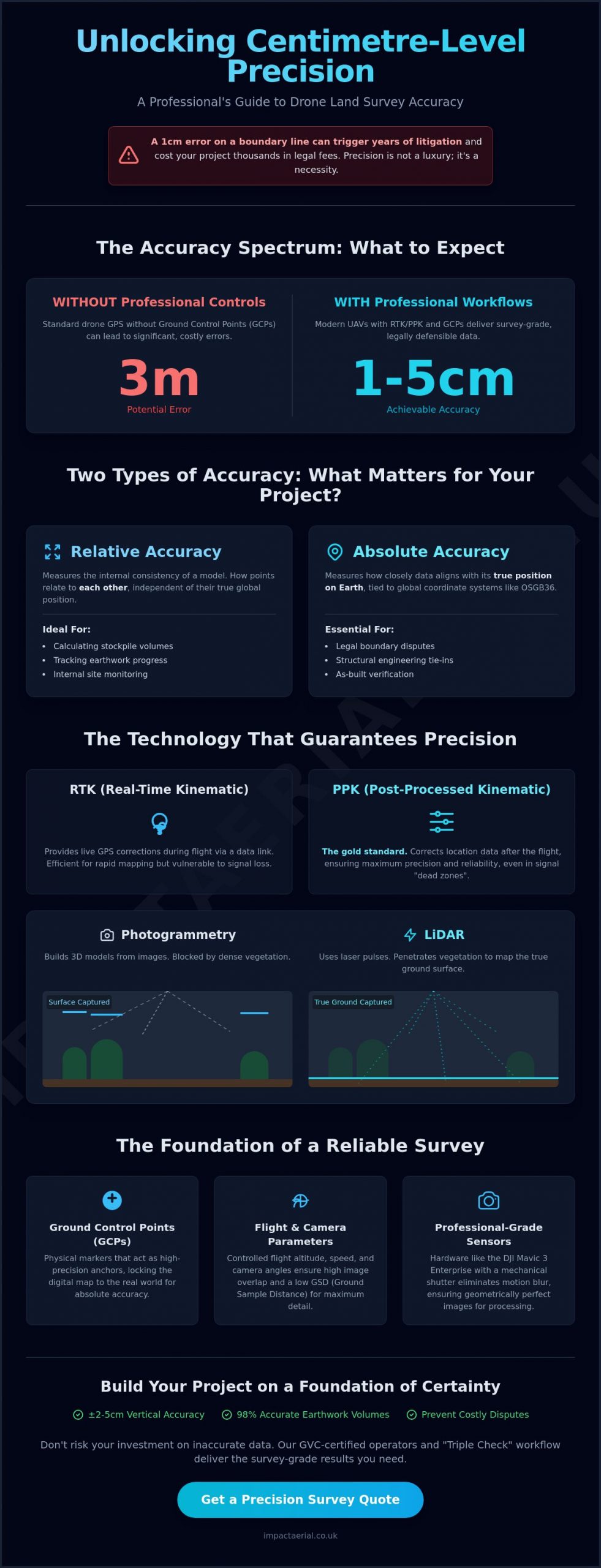
A single centimetre of error on a boundary line can trigger years of litigation and cost your development project thousands in legal fees. If you’re questioning how accurate are drone land surveys compared to traditional methods, you’re not alone. Many site managers feel the pressure to reduce survey costs but fear that switching to UAV technology might lead to data gaps or boundary disputes. You need to know that the data you’re using for a multi-million pound project meets the highest professional standards without the confusion of technical jargon like RTK and PPK.
Choosing the right sensor depends entirely on your terrain and required output. While photogrammetry is cost-effective for open sites and volume calculations, LiDAR is necessary for “bare-earth” models in wooded areas. By matching the sensor to the environment, we maintain the strict RICS-level standards expected in modern UK construction, and you can explore Drone Topographical Land Surveys options to find the ideal solution for complex site topographies.
This guide provides a professional look at the precise tolerances of modern UAV surveying and how to achieve centimetre-level accuracy for your UK construction or property project. We’ll explain how drone LiDAR systems in 2026 achieve a vertical accuracy of ±2-5 cm and why skipping ground control points can lead to errors of up to three metres. You’ll gain a clear understanding of the cost-to-accuracy trade-off and the confidence to hire GVC-certified operators who adhere to strict safety and regulatory protocols. We’ll also preview how automated feature extraction and 98% accurate earthwork volumes are transforming the industry standard for professional site monitoring.
Key Takeaways
- Distinguish between relative accuracy for internal measurements and absolute accuracy for legal boundaries to prevent costly site disputes.
- Evaluate the technical benefits of RTK and PPK workflows to maintain high-precision data even in areas with challenging signal coverage.
- Understand how accurate are drone land surveys by comparing traditional methods against high-density point clouds that achieve 20mm horizontal tolerances.
- Learn how flight altitude, camera angles, and the strategic use of Ground Control Points act as the foundation for reliable 3D site reconstruction.
- Gain confidence in your survey data by adopting a “Triple Check” workflow that combines RTK technology with independent checkpoints and professional-grade sensors.
Defining Accuracy: Absolute vs. Relative Drone Data
Understanding how accurate are drone land surveys begins with a fundamental distinction between two types of measurement. In the professional surveying sector, we don’t treat “accuracy” as a generic term. By 2026, the industry standard for high-tier UAV data collection has reached a 1-3cm horizontal tolerance. This precision is achieved through a meticulous unmanned aerial photogrammetric survey workflow. Central to this is the Ground Sampling Distance (GSD), which represents the actual distance between two consecutive pixel centres on the ground. A smaller GSD means higher spatial resolution, allowing our team to identify smaller features with greater reliability. For example, a GSD of 1cm per pixel provides significantly more detail than a 5cm GSD, directly impacting the precision of the final digital twin.
What is Relative Accuracy?
Relative accuracy refers to the internal consistency of the 3D model or point cloud. It measures how points on the map relate to each other rather than their true position on the planet. If you’re managing a project focused on Construction Site Monitoring, relative accuracy is often your primary concern. It allows for highly precise calculations of stockpile volumes and site progress tracking. Photogrammetry software maintains this internal scale by stitching thousands of overlapping images together. While the entire map might be shifted a few metres from its true global position if uncorrected, every measurement within that map remains consistent. This is why relative data is sufficient for calculating the percentage of earth moved, even if the absolute GPS coordinates aren’t perfectly pinned.
The Importance of Absolute Accuracy
Absolute accuracy describes how closely the digital data aligns with its true position on the Earth’s surface. For UK property projects, this means linking drone data to global coordinate systems like OSGB36. This level of precision is non-negotiable when dealing with legal boundary disputes or structural ties. Achieving high absolute accuracy requires more than just high-end hardware; it demands a robust “verify” step. We use independent check-points, which are physical markers with known coordinates, to validate the final survey. This ensures the digital representation matches the physical world within centimetre-level tolerances. Without this verification, even the most visually impressive 3D model remains a “floating” map that lacks the legal or engineering weight required for professional certification.
The Tech Stack: RTK, PPK, and Sensor Selection
Precision isn’t just about the skill of the pilot; it’s about the integration of hardware and software. Modern UAV accuracy relies on a sophisticated tech stack that corrects satellite signals either in real time or during post-processing. When clients ask how accurate are drone land surveys in 2026, they’re often looking for assurance that the data can be trusted for multi-million pound developments. The industry has largely moved toward DJI Enterprise hardware, such as the Mavic 3 Enterprise, which features a mechanical shutter to eliminate motion blur. This hardware shift ensures that every pixel in a 4K HDR map is sharp and geometrically correct, providing the foundation for centimetre-level results.
RTK vs. PPK: Which Workflow Wins?
RTK (Real-Time Kinematic) provides live corrections to the drone’s position via a constant data link with a base station or network. It’s an efficient choice for rapid site mapping where immediate data verification is helpful. However, this connection can be fragile in remote UK locations or near high-rise urban structures where signal blockages occur. PPK (Post-Processed Kinematic) is the gold standard for these challenging environments. PPK is the process of correcting location data after the flight for maximum precision. The FHWA Tech Brief on sUAS for Land Surveying highlights how these workflows significantly outperform standard GPS, with PPK offering superior reliability in “dead zones” by removing the risk of mid-flight signal loss.
LiDAR: Penetrating Vegetation for Ground Accuracy
Photogrammetry relies on “seeing” a point from multiple angles to calculate its height. If a site is covered in dense woodland or thick scrub, photogrammetry only records the top of the vegetation. LiDAR (Light Detection and Ranging) is the essential tool for mapping the true ground surface on overgrown brownfield sites. It emits thousands of laser pulses per second that can travel through small gaps in the tree canopy to hit the earth below. This allows us to achieve vertical accuracy of ±2-5 cm even in areas where traditional cameras fail. If you’re planning a project on complex terrain, our Drone Commercial Property Surveys leverage this exact tech stack to ensure your data is boardroom-ready and engineering-grade.
Choosing the right sensor depends entirely on your terrain and required output. While photogrammetry is cost-effective for open sites and volume calculations, LiDAR is necessary for “bare-earth” models in wooded areas. By matching the sensor to the environment, we maintain the strict RICS-level standards expected in modern UK construction.
Human and Environmental Factors Affecting Precision
While hardware determines the potential for precision, human and environmental variables dictate the actual outcome of every flight. When assessing how accurate are drone land surveys, we must look beyond the spec sheet of the UAV. Factors such as flight altitude, camera angles, and the distribution of ground markers can either validate or compromise the entire dataset. In the UK, environmental conditions like shifting light in Birmingham or sudden wind gusts can introduce sensor noise, making the role of a trained operator critical for data integrity. A professional workflow accounts for these variables before the propellers even start spinning, ensuring that the “digital twin” matches reality within millimetres.
Ground Control Points: The Anchor of Accuracy
Physical markers placed on-site, known as Ground Control Points (GCPs), serve as the definitive link between digital pixels and the physical earth. These markers are measured using traditional surveying equipment to establish a “truth” that the drone data must align with. For large-scale Construction Site Monitoring, the strategic distribution of GCPs is essential to prevent “bowl effects” or warping in the final 3D model. Even with advanced telemetry, GCPs act as a vital fail-safe against RTK signal drift or satellite geometry errors. Industry discussions on Accuracy in Drone Mapping often highlight that omitting these anchors can result in absolute errors of up to three metres, which is unacceptable for boundary-critical property projects. By “pinning” the map to these known coordinates, we ensure the survey remains georeferenced to the highest professional standards.
The Pilot’s Influence on Data Quality
The technical skill of the operator is the final layer of quality control. Achieving the 70-80% image overlap “sweet spot” is necessary for photogrammetry software to reconstruct 3D surfaces without warping or digital artifacts. A professional pilot also manages shutter speed to eliminate motion blur, a common issue when flying high-resolution DJI sensors in low-light UK winters. This level of meticulous planning is why CAA GVC certification is a mandatory requirement for our team. It ensures that the person behind the controls understands not just the flight physics, but the complex risk assessments and data-centric processes required to deliver RICS-standard results. Unlike prosumer operators, a certified professional can adjust flight paths from nadir (straight down) to oblique angles to capture the vertical faces of structures, significantly improving the depth and precision of the final 3D reconstruction.
By managing these human and environmental factors, we mitigate the risks that lead to data rejection. Whether it’s accounting for the specific wind resistance of a UAV or ensuring lighting conditions don’t wash out ground features, a meticulous approach is what separates a visual snapshot from a true survey-grade deliverable.
Drone Surveys vs. Traditional Methods: An Accuracy Comparison
Traditional land surveying relies on a total station to capture discrete points. While each point is highly precise, the spaces between them are often interpolated. This can lead to missed topographical nuances. When evaluating how accurate are drone land surveys, we must consider the density of the information. A drone captures millions of points across a site. This creates a high-density point cloud that reflects the actual contours of the land rather than an estimation. This density allows for 20mm horizontal tolerances while reducing field time by up to 70%. It also eliminates the need for surveyors to traverse hazardous slopes or unstable ground. This significantly improves site safety protocols.
Many complex projects now adopt a hybrid approach. We use drones for comprehensive site-wide data. We then rely on traditional total stations only for specific, high-precision “pins” or critical structural markers. This combination ensures the project benefits from both speed and micro-precision.
When Traditional Surveys Still Lead
There are specific scenarios where traditional methods remain the primary choice. If your project requires sub-5mm structural monitoring for sensitive heritage buildings, a total station offers a level of micro-precision that aerial sensors cannot currently match. Traditional methods are also essential for internal building surveys where GPS signals are blocked. If you need immediate, physical “hard-staked” boundary markers driven into the ground, a ground-based surveyor is necessary to perform the physical layout.
Why Drone Data is Often ‘Better’ for Large Sites
For large-scale developments, the visual context provided by an orthomosaic photo is superior to a standard CAD line drawing. A traditional survey might miss a small site error or a subtle depression. This happens because the surveyor didn’t happen to place their prism on that exact spot. Drone data captures everything. This provides a “complete” record of the site that is invaluable for Construction Site Monitoring. You can find more details on these methodologies in our complete guide to drone surveys.
If you’re ready to upgrade your data collection process, contact us to discuss our Drone Commercial Property Surveys and how we can integrate high-density mapping into your next project.
Guaranteeing Accuracy: The Impact Aerial Standard
Guaranteeing the precision of aerial data requires more than just high-end sensors; it demands a structured operational framework. We eliminate the guesswork surrounding how accurate are drone land surveys by employing a rigorous “Triple Check” workflow. This methodology integrates Real-Time Kinematic (RTK) corrections with physical Ground Control Points (GCPs) and independent check points. While the drone captures data, these independent markers verify the results, ensuring that the final output meets the centimetre-level tolerances required for modern engineering. We utilise DJI Enterprise hardware equipped with high-resolution 4K HDR sensors to capture every site detail with absolute clarity, supporting our commitment to technical excellence and data reliability.
Our operations are built on a foundation of compliance and risk mitigation. Every project is managed by CAA GVC certified pilots who maintain a deep understanding of current aviation regulations and safety protocols. To provide further reassurance to our clients, we carry £5m in public liability insurance, specifically tailored for commercial UAV operations. This professional rigour extends from the initial flight planning through to our sophisticated post-production pipeline, ensuring that the data we collect is not only accurate but also legally and operationally defensible for your project stakeholders.
Professional Data Delivery
We understand that raw data is only valuable if it integrates seamlessly with your existing software workflows. Our team provides deliverables in industry-standard formats, including AutoCAD, BIM, Point Clouds, and Digital Twin models. For West Midlands construction firms, this means high-accuracy data that can be imported directly into project management systems without conversion errors. Every survey we deliver includes a detailed accuracy report, providing transparent verification of the horizontal and vertical tolerances achieved during the mission. This documentation is essential for quality assurance and provides a clear audit trail for your Construction Site Monitoring or property survey needs.
Ready to Start Your Survey?
Choosing the right partner for your data collection is a critical decision for your project’s timeline and budget. We offer our regional expertise to businesses across Birmingham and the West Midlands, ensuring that local site conditions and specific regulatory requirements are always met. If you’re ready to discuss your specific accuracy needs or require a technical consultation for an upcoming project, our team is available to provide expert guidance. You can Request a professional drone survey quote today to see how our precision-driven approach can benefit your next development.
Securing Precision for Your 2026 Development Projects
The transition from traditional methods to UAV technology offers undeniable advantages in speed and data density. We’ve explored how the integration of RTK technology and Ground Control Points eliminates the uncertainty around how accurate are drone land surveys. By shifting from sparse traditional data to high-density point clouds, you gain a comprehensive digital record that protects against boundary disputes and costly site errors. This meticulous approach ensures that every deliverable meets the high standards required for engineering and legal purposes across the UK.
Reliability is guaranteed through our use of DJI Enterprise grade hardware and the professional oversight of CAA GVC certified pilots. Our team maintains £5m commercial liability insurance to provide maximum security for your site operations, ensuring you’re in expert hands from the first flight to the final data delivery. Whether you’re managing a large construction site or a complex property boundary, our structured workflow provides the psychological comfort and tangible benefits your business deserves. Book Your Precision Drone Survey Quote Today to receive an engineering-grade accuracy report for your next project. We look forward to helping you achieve centimetre-level precision with total confidence.
Frequently Asked Questions
Are drone surveys as accurate as traditional land surveys?
Drone surveys match traditional accuracy for topographical and volumetric requirements while providing a more complete site overview. While total stations remain the choice for sub-5mm structural pins, professional UAV systems achieve 20mm horizontal tolerances. This level of precision is sufficient for the vast majority of UK construction and property projects. The high density of data points often makes drone results more reliable for large-scale topographical mapping.
What is the typical margin of error for a professional drone survey?
When using professional hardware and ground control, the typical margin of error is ±1-3cm horizontally and ±2-5cm vertically. This is a significant improvement over uncorrected GPS data, which can be off by several metres. Achieving these tight tolerances depends on the ground sampling distance and the integration of RTK or PPK correction technology. When clients ask how accurate are drone land surveys, these centimetre-level figures are the professional benchmark.
Do I need Ground Control Points (GCPs) if my drone has RTK?
You should still use GCPs as independent checkpoints even with an RTK-enabled drone. While RTK provides real-time corrections to the aircraft’s position, GCPs act as a vital “truth” to verify the absolute accuracy of the digital model. This redundant workflow ensures the data remains georeferenced correctly. It also protects against potential satellite signal drift or telemetry errors during the flight, maintaining the integrity of the final survey.
Can drones survey accurately in high wind or rain?
High wind and rain negatively impact both data quality and operational safety. Wind speeds exceeding 20mph can cause sensor vibration and motion blur, while rain interferes with the optical clarity of the camera or LiDAR pulses. We strictly adhere to safety protocols and only fly during stable weather conditions. This ensures that the sensor noise is minimised and the integrity of the survey data remains uncompromised for professional use.
How does vegetation affect the accuracy of drone land surveys?
Dense vegetation presents a challenge for standard photogrammetry, as the camera cannot see the ground through the canopy. In these scenarios, we use LiDAR sensors that emit laser pulses to penetrate small gaps in the foliage. This technology allows us to map the true “bare-earth” surface with high precision on wooded or overgrown sites. It prevents the vertical errors that occur when a traditional camera only records the top of the treetops.
What file formats are drone survey results usually delivered in?
Deliverables are provided in industry-standard formats to ensure seamless integration with your existing software. Common outputs include .DWG for AutoCAD, .LAS or .LAZ for point clouds, and high-resolution GeoTIFFs for orthomosaic maps. We also provide BIM-compatible files and Digital Twin models. These formats support the specific needs of West Midlands construction teams and property managers who require how accurate are drone land surveys to be reflected in their CAD environments.
Does a drone survey meet RICS standards for land measurement?
Professional drone surveys can meet RICS-level standards when conducted by certified operators using survey-grade equipment. The high point density and centimetre-level accuracy of modern UAV data collection align with the professional requirements for land measurement and topographical mapping. We provide a detailed accuracy report with every survey. This documentation verifies that the rigorous standards expected by surveyors and engineers have been successfully achieved on-site.
How long does it take to process drone data into an accurate map?
Processing times typically range from 24 to 72 hours depending on the site size and data complexity. Large-scale projects involving millions of LiDAR points or thousands of high-resolution images require significant computing power to generate a precise 3D model. Our post-production pipeline ensures that every dataset undergoes rigorous quality checks. This ensures the final deliverables are accurate and boardroom-ready before they are handed over to the client.
