
A drone map looks incomplete, a roof image appears blurred, or a model shows unexpected gaps. Does that mean the flight failed? Not necessarily. The issue may have arisen during capture, file transfer or review. Identifying where the symptom appears is the first step in troubleshooting common issues with drone data.
Missing or unclear information can affect an inspection, design or construction decision. But a display setting or transfer problem can look like a genuine data-quality issue. Trace the symptom before deciding whether anything needs to be repeated.
This guide explains how to identify the affected files, areas or outputs, then distinguish capture concerns from transfer errors and interpretation issues. You’ll learn what to inspect, when a different way of viewing the data may help, and when professional data collection or review is appropriate. For built-environment projects, clear requirements and a structured handover help keep drone data aligned with the decisions it needs to support.
Key Takeaways
- Use the visible symptom to guide your investigation, but don’t treat appearance alone as proof of a failed flight.
- Check potential causes in sequence: capture conditions, file transfer and organisation, then output interpretation.
- Compare affected files and areas with the intended coverage to identify what evidence to inspect and what to do next.
- When troubleshooting common issues with drone data, record the specific concern and affected material before requesting a review.
- Clear project requirements and a structured handover help align data collection with the decisions your project needs to support.
Troubleshooting Common Drone Data Issues: What Does the Symptom Tell You?
Drone data can include still imagery, thermal outputs, 3D imaging and detailed topological graphics. Each type provides different information, so a concern in one output may not affect the others. A roof image might be difficult to interpret, for example, while the corresponding 3D material shows the area clearly. The first step in troubleshooting common issues with drone data is to describe what you can see without deciding too soon why it happened.
Typical warning signs include an area that seems absent, blurred imagery, inconsistent views of the same feature, or an output that differs from what you expected. These are symptoms, not diagnoses. A gap might indicate missing coverage, but it could also reflect how an output is displayed or which files are open. Similarly, information may be present but difficult to interpret in the current view.
Assess usability against the project’s purpose and agreed deliverables. Images intended to document visible roof condition serve a different purpose from thermal outputs or 3D imaging. If the required location, detail or output type isn’t available, the issue may affect how the project can use the data. For general context on the aircraft and systems involved, see this overview of understanding drone technology.
Which drone data problems can you spot during review?
Describe the concern precisely. A blank or uncovered portion of a map may indicate an apparent coverage gap. An image that is present but blurred is a clarity concern. Inconsistent views can make a feature difficult to compare, while unexpected files or unfamiliar output types may point to an organisation or handover question rather than a capture fault.
- Record the affected file name or output.
- Note the location or feature, such as a roof section or façade.
- Describe whether the area appears absent, unclear or inconsistent.
This record helps distinguish an area with no visible information from one that has been captured but is hard to interpret.
Is the issue in the data or only in its presentation?
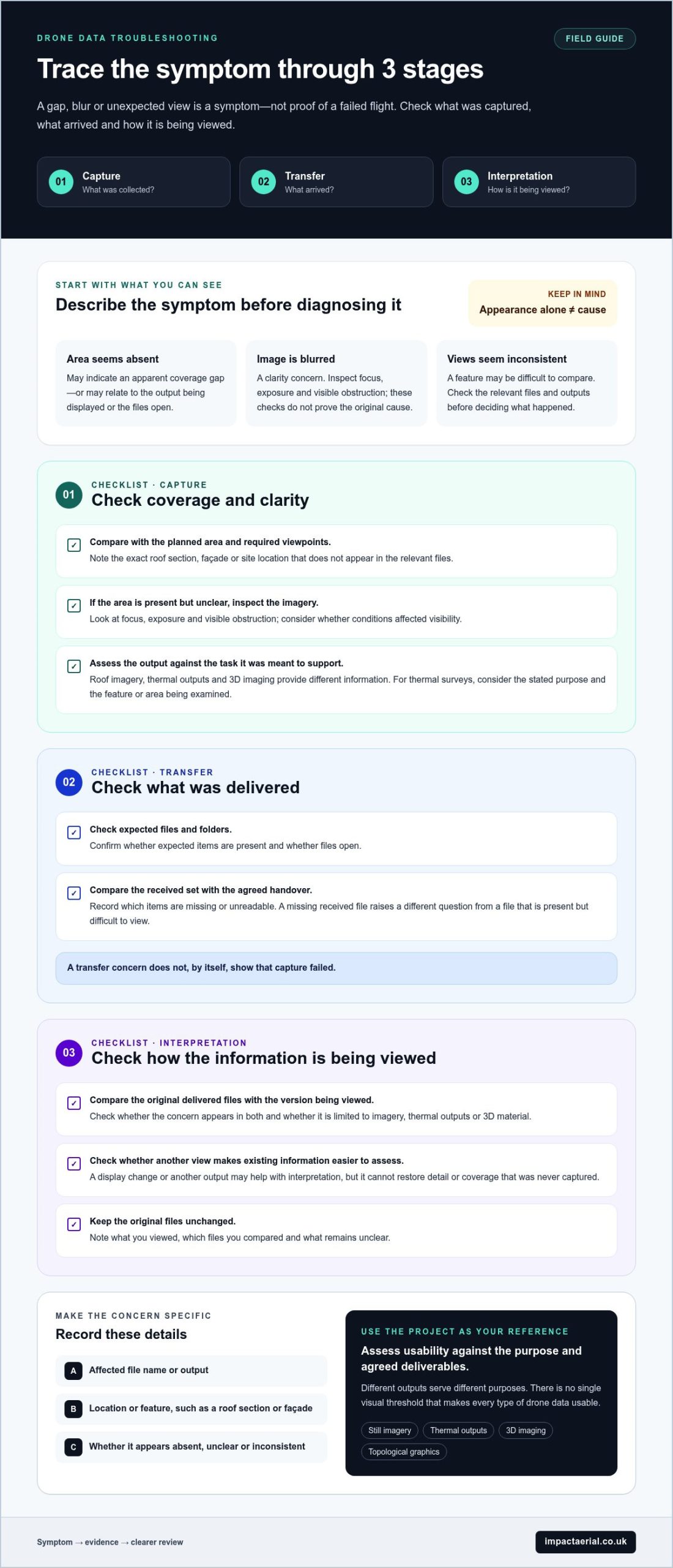
Compare the original delivered files with the version you’re viewing. Check whether the concern appears in both, and whether it affects imagery, thermal outputs or 3D material specifically. A difference between versions may point to presentation or file handling. A repeated gap across the relevant material needs closer review. The symptom alone can’t confirm the cause.
Keep the original files unchanged while documenting the concern. Adjusting a display or reviewing another output may make existing information easier to assess, but it can’t restore detail or coverage that was never captured. Note what you viewed, which files you compared and what remains unclear. This gives the next review a precise starting point instead of relying on a general impression that the data “looks wrong.”
Why Drone Data Problems Happen: Capture, Transfer and Interpretation
A concern in a delivered output can begin at different points in the data process. The material may not show the required area clearly because of capture conditions. A file may be missing or unreadable after transfer. Or the output may be difficult to interpret in its current form. Separating these stages makes troubleshooting common issues with drone data more methodical: check what was collected, what arrived and how it is being viewed before settling on a cause.
These are possible factors, not automatic explanations. Weather, camera setup or flight coverage may be relevant in one case but not another. Use the project purpose and agreed deliverables as your reference. Requirements for roof imagery may differ from those for a thermal image survey or 3D imaging. There is no single visual threshold that makes every type of drone data usable.
Capture-stage causes: coverage, clarity and conditions
Start by comparing the collected material with the planned area and required viewpoints. If a specific roof section, façade or site location doesn’t appear in the relevant files, note the exact location and output affected. If the area is present but difficult to assess, inspect the imagery for focus, exposure and visible obstruction. These checks may help explain unclear imagery, but none proves the original cause on its own.
Environmental conditions and flight coverage may also be relevant. Consider whether conditions affected visibility and whether the available views show the detail needed for the task. For thermal image surveys, assess the output against the stated survey purpose and the feature or area the project set out to examine. Don’t infer a technical fault from appearance alone. Identify what information is unclear and where it occurs.
Transfer and interpretation: where information can appear to go wrong
Check whether the expected files and folders are present, whether files open, and whether the delivered set matches the agreed handover. A file that’s absent from the received folder raises a different question from one that is present but difficult to view. If a transfer appears incomplete, record which items are missing or unreadable rather than assuming the capture itself failed. Impact Aerial delivers data and final work through a shared Google Private Cloud Drive or WeTransfer Pro.
Interpretation can change how information appears. Compare original imagery with edited or presented work if the two look different, and identify whether the concern is limited to one output. Post-production tools such as Adobe Lightroom, Adobe Premiere Pro and DaVinci Resolve may be used to prepare or present work, but reviewing a different version cannot recreate detail that wasn’t captured in the first place.
Keep your checks tied to the agreed requirements, not a universal expectation of accuracy or coverage. If the output needs to support a built-environment decision, a clear project brief helps establish which data types and views matter. For projects requiring planned drone data collection and defined outputs, Impact Aerial’s drone survey services provide a structured starting point.
How to Diagnose Drone Data Issues: Compare the Symptom with the Evidence
A useful diagnosis starts with a comparison, not a conclusion. Match the visible symptom to the project brief, required coverage and intended inspection or survey use. A missing-looking area might reflect a file that wasn’t included in the handover, an unclear view or information that isn’t present in the collected material. Each possibility calls for a different next step.
Use the table as a guide. The likely stage is a starting point for investigation, not proof of where the issue began.
A practical symptom-to-check diagnostic table
| Symptom | Evidence to inspect | Likely stage | Sensible next action |
|---|---|---|---|
| An area appears missing | Compare the affected location with required coverage and the available files or outputs. | Capture or transfer | Check whether any relevant material exists in the delivered set. Record the location if it remains absent. |
| Imagery looks unclear | Inspect original files and the specific views showing the concern. Compare affected views with other material from the same area. | Capture or presentation | Determine whether the issue affects one file, a group of views or the current display before assessing the whole dataset. |
| A 3D or topological output seems unexpected | Compare the output with the agreed project requirement and intended use. | Interpretation or output preparation | Describe what differs from the requirement and identify the relevant output or location for review. |
| Expected material can’t be found or opened | Check the delivered folders, file names and readability against the handover. | Transfer or organisation | List the affected files and check whether another relevant item is present before concluding that capture is incomplete. |
Keep the comparison specific. If an inspection requires a view of a particular roof feature, confirm whether that feature appears in the files intended for that use. If a 3D output looks different from what you expected, first check what deliverable was agreed. An unfamiliar presentation doesn’t by itself establish that the underlying data is defective.
This evidence-led approach is central to troubleshooting common issues with drone data. Note the file names, locations and output types involved, then state what the project needed and what you can currently see. Avoid broad conclusions such as “the survey failed” until you’ve compared the relevant material.
When is a review enough, and when might further capture be needed?
A file or organisation check may resolve a concern if relevant material exists but is difficult to locate, open or compare. If the required information appears absent from all available material, further capture may be considered in light of the project requirements and the evidence. Neither outcome can be assumed from a single symptom.
For technical or safety-critical decisions, use appropriate professional judgement. A visual review can help identify the question, but it shouldn’t replace the expertise required to assess data for its intended purpose. Document the evidence and the decision it needs to support so any review can focus on the affected area and deliverable.
A Drone Data Quality Checklist for Review, Handover and Escalation
A disciplined review starts with the project requirement, not a general impression that the files look wrong. Before escalating a concern, check the delivered material against the intended inspection or survey use, then record what is affected. This helps distinguish a presentation preference from missing evidence that could matter to a project decision.
Use this checklist to organise your review:
- Purpose: Identify the inspection, survey or decision the data needs to support.
- Files: Check that expected files and folders are present and open as intended.
- Coverage: Compare the available views and outputs with the locations and features required.
- Clarity: Note whether information is absent, present but difficult to interpret, or inconsistent between views.
- Output format: Confirm that the delivered types of material match the agreed requirement.
- Handover: Record which delivered items you reviewed and retain the original materials.
These checks make troubleshooting common issues with drone data more precise. A different viewing preference is not necessarily a data-quality failure. If the project needs evidence of a specific feature and that information isn’t available in the relevant material, describe the gap clearly for review.
Review files against the original project requirement
Compare the received deliverables with the agreed survey or inspection purpose. Note the affected location, view and output type, and leave original files unchanged. Describe the concern as missing data, unclear data or a presentation issue. For broader context on planning and using aerial data, see this drone survey guide.
Prepare a useful issue report for professional review
Keep the report factual and concise. Include the project purpose, affected file names or locations, output type and what you observed. State what inspection task or decision the data needs to support. Keep original materials alongside any edited or presented versions so the reviewer can understand the concern in context.
A specific report is more useful than a broad request to check everything. Identify the location and file where a required detail is difficult to assess, then explain why that detail matters to the project. If the concern relates to several outputs, list each one separately. This gives the review a defined scope and helps distinguish a presentation question from a possible information gap.
For built-environment projects, requirements can shape the data collected and how it is handed over. Discuss your drone data collection requirements with Impact Aerial to define project outputs around their intended use.
How Professional Drone Data Collection Can Reduce Repeat Problems
Clear project requirements established before a flight give the team a practical reference for capture, review and handover. Consultation and a site survey help define the purpose of the work, the locations or features of interest, and the outputs needed. This makes it easier to assess whether the delivered material addresses the brief, rather than relying on assumptions about what a drone survey should contain.
A defined brief can help reduce avoidable gaps between what a project needs and what the collected data is expected to show. For built-environment work, required outputs may include high-resolution roof and façade imagery, 3D imaging or detailed topological graphics. The appropriate combination depends on the project’s purpose and agreed deliverables.
What happens when Impact Aerial collects drone data?
Impact Aerial follows a structured seven-stage workflow, from defining project needs to final handover:
- Consultation
- Site Survey
- Safety Assessment
- Flight
- Post-Production
- Presentation
- Handover & Sign-Off
Each stage supports a clear process for planning and delivering the agreed work. Impact Aerial’s pilots are CAA-GVC Certified, and the company holds full UK CAA Operational Authorisation and £5 million commercial liability insurance. For readers comparing survey approaches, this guide to professional drone survey information offers additional context.
From collected material to a usable project handover
The capture platform and presentation are considered in relation to the project requirements. Impact Aerial uses the DJI Matrice 210 Enterprise platform, with 4K HDR video capability. The collected material can support agreed outputs such as high-resolution imagery, 3D imaging and detailed topological graphics, helping make the handover relevant to the work the data needs to inform.
Data and final work are delivered through a shared Google Private Cloud Drive or WeTransfer Pro. A clear handover helps the recipient understand what has been provided and how it relates to the project brief. If a question arises during review, identifying the output and requirement makes it easier to explain the concern precisely, rather than treating every difference in appearance as a capture problem. This structured approach supports troubleshooting common issues with drone data by linking the evidence to the project purpose.
If you’re planning a survey or need outputs defined around a built-environment project, request a quote for your project and outline the information you need the data to support.
Make Your Next Data Decision with Confidence
Before acting on an unclear output, decide what information the next project decision depends on. A concise brief that identifies the purpose, required views and intended use gives data collection and review a shared reference point. It also makes future handovers easier to assess, because the question is specific: does the material support the task it was collected for?
That clarity is useful whether you’re planning a new survey or determining what evidence an existing inspection needs. If an issue remains uncertain, document the affected material and the decision it relates to. A focused review can help establish a sensible next step without assuming that every visual concern means the flight must be repeated.
For built-environment projects, troubleshooting common issues with drone data is ultimately about making sure the information is fit for its intended role. Define what you need the data to show, and let that purpose guide the process from planning through handover.
Request a free, no-obligation quote for your project and outline the decision your data needs to support.
Frequently Asked Questions
Why do drone images look blurry or unclear?
Drone images may look unclear because of focus, movement during capture, limited visibility or how a file is displayed. Check the original file at a suitable viewing size, then compare the particular view with other images of the same feature. One unclear roof image doesn’t necessarily mean every view is unusable. Note which files and areas are affected before deciding whether the issue concerns the data or its display.
Can missing drone data be recovered after a flight?
Sometimes the information exists but is misplaced or wasn’t included in the transfer. Information that was never captured is a different matter. Check the delivered folders and other available project files for the relevant area or output before concluding it’s missing. Recovery depends on the source material and what remains available. If the required evidence isn’t present in any collected material, don’t assume it can be recreated after the flight.
Does GPS trouble always make drone survey data unusable?
No. A GPS concern doesn’t automatically make every drone survey output unusable. The effect depends on the project requirement and the evidence available in the collected material. A visual record may still be useful for one purpose, while a decision that depends on location-specific survey information may need closer assessment. For consequential technical or safety-related decisions, have the relevant evidence assessed using appropriate professional judgement.
Can drone data be corrected after it has been collected?
Some file organisation or presentation issues may be addressed by locating the correct material or reviewing another version of an output. That’s different from missing source information. Post-production may change how existing material is prepared or presented, but it can’t reliably recreate a feature or detail that wasn’t recorded. Before making changes, retain the original files and identify whether the concern is about how information appears or whether it’s absent.
What should I send when reporting a drone data problem?
Provide the project purpose, affected files or locations, the output you expected and a plain description of what seems wrong. For example, identify the building elevation and image where a feature is difficult to assess, then explain the inspection task it relates to. Keep the original files available alongside any edited versions. This gives a reviewer useful context without assuming a particular file format or claiming what caused the issue.
How do I know whether drone data is suitable for a building inspection?
Suitability depends on the inspection purpose, required views and evidence available in the delivered material. Consider whether the relevant building areas and features can be assessed in the outputs provided, and whether any limitations affect the inspection task. Aerial imagery can inform a review, but it doesn’t replace professional judgement or a formal inspection where one is needed. For significant decisions, assess the data in the context of the full inspection requirements.
How are completed drone survey files delivered by Impact Aerial?
Impact Aerial provides completed drone survey files through a shared Google Private Cloud Drive or WeTransfer Pro. The project handover follows a structured workflow that begins with consultation and proceeds through to Handover & Sign-Off. To make review straightforward, keep track of the project outputs received and relate any questions to the relevant work.
 2 Norton Drive, Wythall, Birmingham, B47 6HH Company registration number: 11138586. VAT Number: 366 9068 55


