

What can a drone tell you about a commercial building when its roof and upper elevations are difficult to reach? A commercial property drone survey captures aerial views of visible external surfaces, creating a practical visual record without requiring someone to access each area directly. It can also help limit disruption to routine site operations.
Aerial images are useful evidence, but they don’t answer every property question. They can help identify areas for closer attention, but they can’t reveal concealed defects or replace a hands-on assessment when one is needed.
This guide explains where drone surveys add value, how the process works and how aerial evidence can complement traditional property inspections. It also covers what to define before a flight, from the areas to document to reporting needs and site-specific safety arrangements. Impact Aerial provides property imagery and survey data collection across the UK, using CAA GVC certified pilots and commercial-grade enterprise drones. A clear brief helps shape the capture plan around the information your team needs.
Key Takeaways
- See how a commercial property drone survey can document roofs, façades and other elevated areas for a useful visual record.
- Learn the stages of planning and delivery, from defining the survey objective to organising findings around the building’s needs.
- Compare drone imagery with conventional inspections to understand which questions each method can help answer.
- Use a practical preparation checklist to account for access, occupied areas, site activity and conditions that may affect flight planning.
- Discover how Impact Aerial’s UK-wide property survey service can support your project, with scope and deliverables shaped around its requirements.
What a commercial property drone survey can show you
A commercial property drone survey is planned aerial image capture focused on areas relevant to a specific property-management question. From suitable viewpoints, it can document visible parts of roofs, façades, chimneys and other elevated or difficult-to-access areas, building a visual record without requiring direct access to each location.
The value comes from connecting the images to a decision. A roof overview can help a facilities team prioritise areas for closer inspection. Façade views may support maintenance records or help an asset manager review visible changes before planning works. The imagery shows what is visible from the captured angles; it doesn’t automatically explain the cause or extent of a concern.
This video offers a look at the preparation that can take place before a commercial drone flight:
Which commercial property questions can aerial imagery help answer?
Useful survey questions are specific and tied to a next step, rather than expecting images to diagnose every defect. For example:
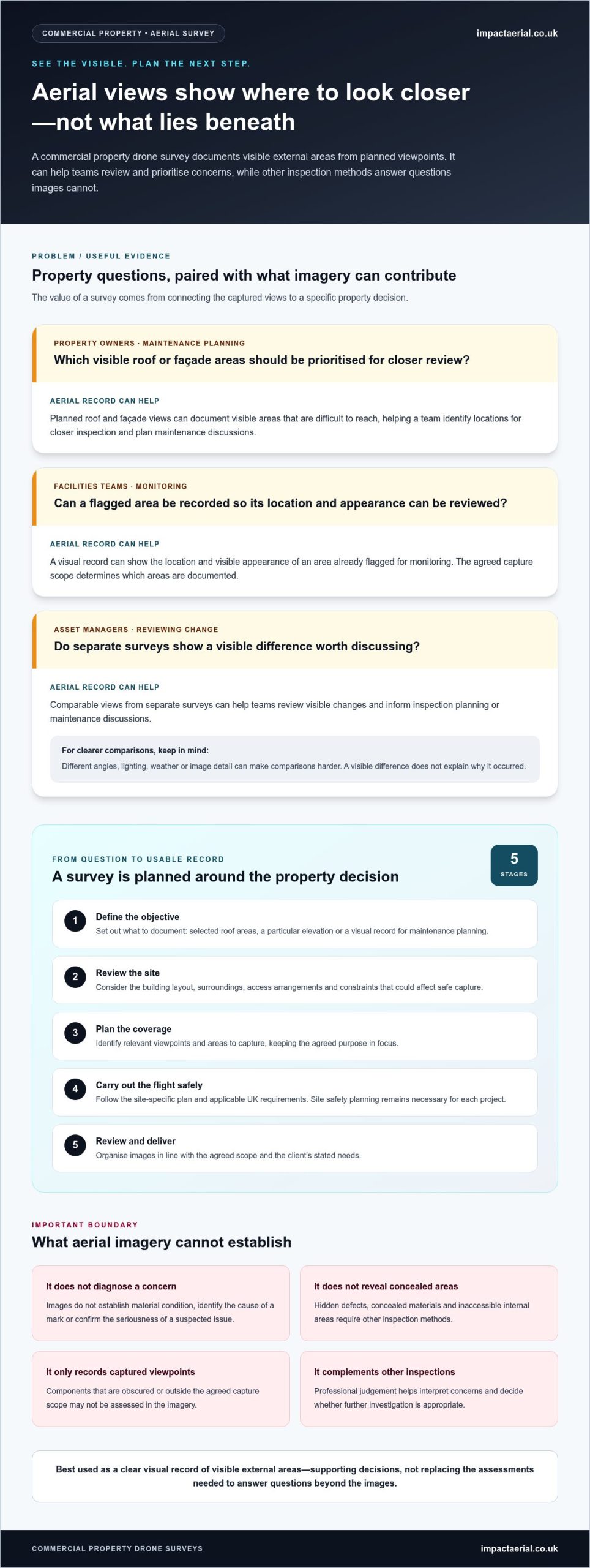
- Property owners: Which visible roof or façade areas should be prioritised for closer review when planning maintenance?
- Facilities teams: Can a visual record help track the location and appearance of an area already flagged for monitoring?
- Asset managers: Do comparable views from separate surveys show a visible change that should inform inspection planning or maintenance discussions?
Repeat surveys using comparable viewpoints can help teams review visible differences over time. Consistency matters: changes in angle, lighting, weather or image detail can make comparisons harder. An unmanned aerial photogrammetric survey uses overlapping aerial images to support the creation of mapped or modelled records. The right approach depends on the project objectives and required outputs.
What a drone survey does not replace
Aerial documentation is not a comprehensive building condition assessment. Images show visible surfaces from the captured viewpoints, but they don’t establish material condition, identify the cause of a mark or confirm the seriousness of a suspected issue. Professional judgement remains important when interpreting concerns and deciding whether further investigation is appropriate.
Concealed materials, hidden defects and inaccessible internal areas require other inspection methods. A drone view also can’t assess components that are obscured or outside the agreed capture scope. Used appropriately, aerial evidence complements other property inspections: it documents external areas and informs next steps, while other assessments address questions that images alone cannot answer.
How a commercial property drone survey is planned and delivered
A useful survey starts with the property question, not the flight path. The building, areas of interest and intended use of the imagery shape the scope, capture plan and final record. A well-defined scope clarifies which areas the imagery can document and how that information may support a property decision.
Impact Aerial manages commercial property survey projects from initial consultation through to delivery. The process is tailored to the site and may include these stages:
- Define the objective. Set out what the survey should document, such as selected roof areas, a particular elevation or a visual record for maintenance planning.
- Review the site. Consider the building layout, surroundings, access arrangements and constraints that could affect safe capture.
- Plan the coverage. Identify relevant viewpoints and areas to capture, keeping the agreed purpose in focus.
- Carry out the flight safely. The pilot follows the project’s site-specific plan and applicable UK requirements. Impact Aerial’s CAA GVC certified pilots and commercial liability insurance provide relevant reassurance, but don’t replace the safety planning required for each site.
- Review and deliver. Images are organised in line with the agreed scope, so the resulting record reflects the client’s stated needs.
Scoping the building and the information required
Before capture, identify the property type, the roof areas or elevations of interest, access constraints and the decision the survey should inform. A warehouse roof survey may need different coverage from a multi-storey office façade record. Building access, tenant activity and routine site operations also matter. Coordinating the work around these conditions helps define practical viewpoints and avoid unnecessary disruption.
For wider context on aerial data collection and how survey approaches differ, explore this complete guide to drone surveys. Each property project needs a scope based on its site and information requirements.
From aerial capture to usable property records
Planned flight paths and viewpoints direct attention to the agreed areas and support a coherent visual record. If future comparison is a goal, noting important locations and angles during scoping can help inform later capture planning. It doesn’t guarantee identical conditions or explain why a visible difference has occurred.
Image review and reporting after the flight should stay within the agreed scope. The project brief can establish which areas to document and how to organise the findings, without assuming a particular file format, measurement or diagnosis. For UK operations, current Civil Aviation Authority requirements and site-specific permissions must guide planning. The FAA regulations for commercial drone operations relate to the United States, so they should not be treated as UK rules.
For a project-specific discussion about commercial property survey planning with Impact Aerial, start with the building, the areas of interest and the decision the visual record needs to support.
Drone survey or conventional commercial property survey: which fits?
The right method depends on the property question and the evidence required. A drone survey documents selected external areas from the air, while a conventional inspection may involve closer physical examination, internal access or a broader assessment. The methods are not interchangeable. Combining them can provide a fuller picture when a project needs both aerial records and detailed assessment.
| Consideration | Drone survey | Conventional survey or inspection |
|---|---|---|
| Access | Captures external views from planned aerial viewpoints, including some elevated areas that may be difficult to reach directly. | Access depends on the inspection method. It may involve ground-level review, physical access to building areas or entry indoors. |
| Visible coverage | Documents the agreed visible external areas, such as selected roof sections and façades. | Coverage depends on the survey scope and method. Closer inspection may allow a practitioner to examine specific accessible components. |
| Internal inspection | Doesn’t document internal spaces or concealed building elements through aerial imagery. | Can include internal areas when they fall within the agreed inspection scope and access is available. |
| Typical purpose | Builds a visual record of external areas or helps identify locations for further review. | May address broader condition questions, internal concerns or closer examination of particular components. |
When aerial property imagery is a useful first step
A commercial property drone survey can suit an initial visual review of elevated or difficult-to-access areas, particularly when a team wants to see what is visible before deciding where to direct further attention. An asset manager, for example, could use roof imagery to mark areas for follow-up. A facilities team might add façade views to its maintenance records. These records support planning, but they don’t confirm a defect or its cause.
The value of the imagery depends on the viewpoints captured and the agreed scope. Plant, parapets, neighbouring structures or other obstructions may hide areas from view. Treat the images as evidence of what was documented, not as a complete account of every building element.
When a broader building survey is still needed
If the question concerns internal condition, concealed defects, material performance or the cause of a visible concern, aerial imagery alone won’t provide the answer. Other inspection methods may be needed to access, test or assess the relevant components. The appropriate approach depends on the issue and the professional judgement required.
An aerial survey and a condition survey can serve complementary purposes: one records agreed external views, while the other addresses broader or more detailed condition questions. The commercial property drone survey guide explores property-focused applications and how aerial documentation can fit into asset management.
How to prepare a commercial site for a drone survey
Good preparation helps the survey team focus on the right areas and plan around an occupied site. Before a commercial property drone survey, share clear objectives and practical site information. Weather, surrounding structures and activity on the day can all influence flight planning, so the capture plan needs to account for conditions at the property.
Use this checklist to prepare:
- Define the survey objective: Explain what decision the imagery should support and which parts of the building matter most.
- Identify the property and priority areas: Note relevant roofs, façades or other external areas, and flag any known concerns that need visual documentation.
- Share access arrangements: Set out how the team can reach the site and any access limits that could affect setup or safe coordination.
- Describe occupancy and activity: Identify occupied spaces, tenant operations, busy areas and site routines to consider when planning capture.
- Provide site contacts and constraints: Share relevant contact details and explain operational restrictions that could affect where or when the survey can take place.
Information to share before the site visit
Start with the property address or site identification, the survey purpose and the areas that need attention. A marked-up plan or clear written description can distinguish priority locations from areas outside the intended scope. Include known access restrictions, occupied spaces and the contact responsible for site coordination. Clear objectives help the team plan useful aerial coverage instead of capturing views that don’t support the property decision.
Safety, permissions and operating conditions
Every site needs a project-specific assessment. Nearby structures may affect available viewpoints, while site activity can influence how the flight is coordinated. Weather may also affect whether planned capture can be carried out safely and effectively. The operator must assess applicable aviation requirements and permissions for the specific operation, rather than relying on a generic plan.
Impact Aerial’s CAA GVC certified pilots and £5m commercial liability insurance provide relevant reassurance, but credentials and insurance don’t replace site-specific safety planning. Current CAA rules and any required permissions should be considered for each operation. The UK drone licence and CAA rules guide provides additional regulatory background.
Before the visit, align survey priorities with the site contact and communicate any occupancy or operational constraints. This gives the team a clearer basis for planning and helps the property team prepare staff and site areas. To plan a survey around your building and its operational needs, discuss your commercial property drone survey with Impact Aerial.
Book a commercial property drone survey with Impact Aerial
Aerial surveys are well suited to documenting visible external areas, particularly roofs and façades that are difficult to view from the ground. They give property owners, facilities teams and asset managers a visual record to inform maintenance planning or identify areas for closer review. They don’t provide a full condition assessment: internal spaces, concealed defects and detailed diagnosis may require other inspection methods.
Impact Aerial provides commercial property drone surveys across the UK, based in Birmingham and the West Midlands. The team manages each project from initial consultation through to delivery, shaping the scope around the building, survey purpose and areas that need attention. CAA GVC certified pilots use commercial-grade DJI Enterprise drones with 4K HDR cameras. Impact Aerial also holds £5m commercial liability insurance. These credentials support the work, alongside the site-specific planning every operation requires.
What to include in a survey enquiry
A clear brief helps establish what the survey should document and how to plan around the property. Include practical site details as well as the reason for the survey, so the proposed scope reflects your priorities rather than capturing unnecessary views.
- Property location and building type: Identify the site and describe the building, such as an office, warehouse or other commercial premises.
- Survey objective: Explain what decision the imagery should support, for example creating an external visual record or reviewing selected roof areas.
- Priority areas: Specify relevant elevations, roof sections or other external locations that need attention.
- Access and occupancy: Note access arrangements, occupied spaces, tenant activity and relevant site contacts.
- Operating conditions: Describe site activity or operational constraints that may affect planning and coordination.
These details give the project team a useful starting point for discussing coverage and defining a project-specific scope. They also bring site considerations into view before the capture plan is developed.
What clients can expect from Impact Aerial
From the initial consultation through to project delivery, Impact Aerial works with the client to define the survey purpose and plan aerial data collection around the property. The agreed scope guides what is captured and how the imagery is organised. The survey records agreed visible areas, rather than providing a guaranteed diagnosis or replacing a full building assessment.
With UK-wide coverage, certified pilots and commercial-grade equipment, Impact Aerial provides aerial documentation for property teams. To discuss your requirements, discuss a commercial property drone survey with Impact Aerial.
Turn aerial evidence into a clearer next step
Before commissioning a commercial property drone survey, decide how the visual record will support your property-management work. It might help prioritise areas for closer attention, brief colleagues or provide context for a maintenance discussion. Giving the imagery a defined role connects the survey to practical decisions rather than leaving it as a standalone record.
Then identify who needs to use the information and what action it should help them consider. If the images raise questions beyond visible external conditions, they can inform the next stage of assessment without being mistaken for a complete diagnosis. That distinction helps asset teams use aerial evidence appropriately and make follow-up decisions in light of the issue.
Impact Aerial can discuss your property, priorities and intended use for the imagery as a starting point for project planning. Discuss your commercial property drone survey with Impact Aerial to plan a focused visual record for your building.
Frequently Asked Questions
What is a commercial property drone survey?
A commercial property drone survey uses a planned drone flight to collect aerial images of specified areas of a building. The resulting record helps property teams review external features beyond ground-level views. Its usefulness depends on the areas captured and the question the survey is intended to inform. It documents visible evidence, rather than automatically measuring every component or diagnosing the cause of a concern.
Can a drone survey replace a commercial building survey?
No. A drone survey provides aerial evidence of visible external areas, while a commercial building survey may investigate wider condition questions, including internal spaces and building elements that images can’t reveal. Roof imagery, for example, could help indicate where a closer inspection may be useful, but it can’t establish the condition of concealed materials. The approaches can complement each other when a property decision needs both visual records and professional assessment.
What areas of a commercial building can a drone survey capture?
Depending on the agreed scope, a drone may capture visible sections of roofs, façades, chimneys and other elevated external features. The survey plan can focus on particular elevations or areas relevant to a property-management question. Obstructions, site conditions or the available viewpoint can limit coverage, so not every feature will necessarily be visible. Share priority locations in advance to help shape the capture plan.
Are commercial property drone surveys safe and legal in the UK?
They can be carried out safely and lawfully when the operation is planned in line with current UK aviation requirements and any site-specific permissions. The operator needs to assess the location, surroundings and conditions for each flight, rather than assuming one approach fits every site. Impact Aerial uses CAA GVC certified pilots. Certification supports professional operation, but it doesn’t remove the need for site-specific safety planning.
How do I prepare a commercial property for a drone survey?
Provide the property location, building type, survey purpose and priority areas, along with access restrictions and relevant site contacts. Also flag tenant activity, occupied spaces and operational constraints that could affect coordination. If particular views matter, describe their location clearly. This information helps the survey team plan around the site and focus capture on imagery that serves a defined purpose.
Can drone survey images help with property maintenance planning?
Yes. Images can give maintenance teams a visual reference when reviewing external areas, discussing priorities or planning where a closer inspection may be useful. A facilities manager, for example, could use captured views to show colleagues the location of a visible concern. Images can support decisions, but they don’t confirm the cause, severity or repair required. Use them alongside appropriate professional assessment when the issue needs diagnosis.
What equipment does Impact Aerial use for commercial property drone surveys?
Impact Aerial uses commercial-grade DJI Enterprise drones equipped with 4K HDR cameras for its property survey work. The equipment captures aerial imagery for review of the areas included in the project scope. The building and survey objective determine which views are useful, so the intended coverage should guide planning. The imagery documents visible conditions; it shouldn’t be treated as a guarantee of measurements, defect identification or a particular finding.
 2 Norton Drive, Wythall, Birmingham, B47 6HH Company registration number: 11138586. VAT Number: 366 9068 55


