
The Hidden Costs of Inaccurate Survey Data: What UK Projects Need to Know

What if a survey that looked like a saving became the reason a project had to pause, change direction or repeat work? The hidden costs of inaccurate survey data can surface long after capture, when teams rely on information for design, procurement or construction. A missing area or unclear reference may be manageable early on, but harder to resolve once decisions and site activity depend on the data.

It’s reasonable to want a survey that fits the project budget and programme. The lowest initial fee, however, doesn’t always mean the most economical approach overall. A useful comparison starts with the decision the information needs to support, then considers the required coverage, detail, checks and deliverables.

This article explains how unreliable or unsuitable data can contribute to rework, delays, budget pressure and disputes, and how to reduce those risks. You’ll learn how to compare survey approaches, match data requirements to project decisions and agree practical quality checks before work begins. For property, building and construction projects, clear planning helps make aerial data collection more useful to the people who need to act on it.

Key Takeaways

  • The hidden costs of inaccurate survey data can extend beyond the survey itself, emerging when teams act on information that doesn’t suit the project.
  • Assess reliability by looking at the survey scope, capture, processing and coverage, not just the finished files.
  • Compare drone capture, ground-based methods and existing records by access, coverage and intended outputs. No single approach is right for every project.
  • Before commissioning, identify who will use the data, which decisions it must support and how the deliverables will be reviewed.
  • A clear capture plan, agreed outputs and practical quality checks can help make drone data collection more useful for property, building and construction projects.

How inaccurate survey data creates hidden costs across a UK project

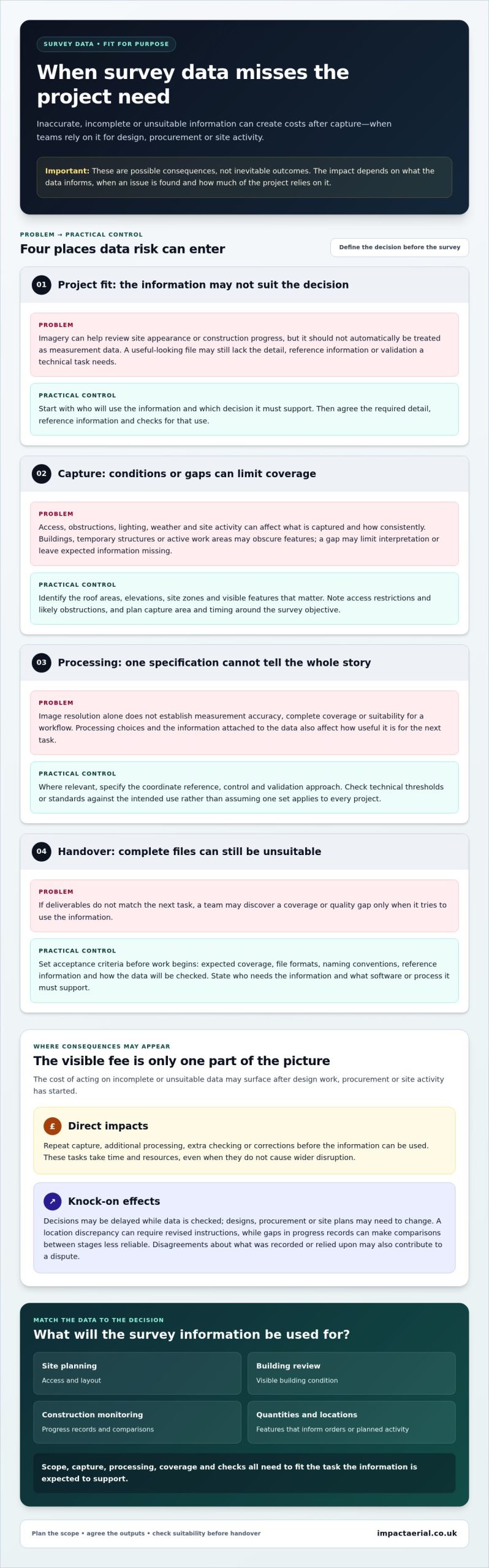
The survey fee is visible in a project budget. The costs of acting on incomplete, unsuitable or unreliable data may appear later, after design work, procurement or site activity has begun. A missing roof area, obscured feature or unclear location could mean repeating capture, revising a design or correcting work. If the information informs quantities or positions, errors may also affect what is ordered or where activity is planned.

Hidden survey-data costs are downstream costs arising from decisions made using data that isn’t suitable for its intended use. They are possible consequences, not inevitable results. The impact depends on what the data informs, when a problem is found and how much of the project relies on it.

Clear communication about findings matters too. This video discusses how to present disappointing data without losing credibility:

Which project decisions depend on survey data?

Teams may use survey information to plan site access and layout, review visible building condition, monitor construction progress or understand the quantity and location of features. Each task needs information suited to that decision. For example, imagery may help a team review site appearance or progress, but it should not automatically be treated as measurement data. The required level of detail, reference information and validation depends on how the results will be used.

Errors can arise at any stage, from defining what needs to be recorded through to capture, measurement and processing. The Total Survey Error framework offers an overview of how different error sources can affect data. For a project team, the practical test is whether the agreed scope and resulting information match the task. Ask which areas and features must be covered, what decisions depend on them and what checks will show that the deliverables are suitable.

Direct costs and knock-on costs are not the same

Direct impacts may include repeat capture, additional processing, extra checking or corrections before the information can be used. These tasks take time and resources, even when they don’t cause wider disruption.

Knock-on effects can follow when a decision is delayed while data is checked, or when design, procurement or site plans need to change. A location discrepancy, for example, may mean coordinating revised instructions. A gap in progress records may make comparisons between stages less reliable. Disagreements about what was recorded or relied upon can also contribute to a dispute. None of these outcomes is automatic, but each shows why the hidden costs of inaccurate survey data depend on the decisions connected to it.

Why survey data becomes unreliable: capture, processing, and project fit

Survey data is fit for purpose when it suits a clearly stated project decision and the way the information will be used. Images that work well for reviewing visible site conditions may not provide the measurement or reference information needed for a technical design decision. Define the intended use first, then specify the capture approach and deliverables that support it.

Survey quality must be judged against the intended use, not one isolated specification. Image resolution alone, for example, doesn’t establish measurement accuracy, complete coverage or suitability for a particular workflow. Those depend on the project requirements and the full capture and processing approach.

Capture conditions and coverage can affect usefulness

Access, obstructions, lighting, weather and site activity can all affect what a survey captures and how consistently. Buildings, temporary structures or active work areas may obscure features. Changing conditions can also make records harder to compare. A gap doesn’t automatically make a dataset unusable, but it may limit interpretation or leave the team without information it expected.

Plan the capture area and timing around the survey objective. Identify which elevations, roof areas, site zones or visible features matter, and note access restrictions or likely obstructions. That gives the capture team a practical basis for planning coverage and helps the project team identify constraints before they affect the usefulness of the data.

Processing, reference information, and acceptance criteria

Capture is only one part of the workflow. Processing choices and the information attached to the data can affect whether it works for the next task. Where relevant, define the required coordinate reference, control and validation approach in the project specification. Check any technical thresholds or standards against the intended use rather than assuming that one set of requirements applies to every project.

Set acceptance criteria before work begins. Specify expected coverage, file formats, naming conventions, reference information and how the data will be checked before handover. State who needs to use the information and what software or process it must support. Clear criteria help distinguish a genuine coverage or quality gap from a delivery that is complete but unsuitable for the next task.

RICS provides guidance on professional data handling, a useful reference when considering how project information is managed. Impact Aerial can plan drone data collection around the decisions the information needs to inform. Explore drone survey planning with Impact Aerial as part of defining those requirements.
The Hidden Costs of Inaccurate Survey Data: What UK Projects Need to Know

How to compare survey methods and data-quality controls

Start with the decision the data must support and the consequences if key information is missing or wrong. Aerial capture, ground-based approaches and existing records have different strengths and limitations. None is automatically the cheapest, most accurate or most suitable option for every site.

Use the comparison below to frame a project discussion. The right approach may involve one method or a combination, depending on access, coverage, purpose and required outputs.

Project need Data requirement Validation question Method considerations
Site-wide planning A current overview of relevant areas and features Does the dataset cover the areas needed for the plan? Aerial capture can provide broad visual context; ground-based work may be needed for details that require close inspection.
Building condition review Records of visible features on specified parts of a structure Are the required areas visible and documented consistently? Access, obstructions and the level of detail needed may influence whether aerial, ground-based or combined capture is appropriate.
Repeat progress documentation Comparable records across agreed dates or stages Can the records be reviewed consistently over time? Repeat aerial capture may suit broad site documentation; existing records can provide context but may differ in date or coverage.
Measurement or location decision Information with agreed reference and validation requirements Does the data meet the project’s specified checks for this use? Method selection should follow the technical requirement. Visual review alone may not be enough.

When can aerial data collection suit a project?

Aerial data collection can be useful when a project needs a site overview, documentation of hard-to-access areas or repeat records. It can support property, building and construction work when the capture plan is tailored to the required areas and purpose. Suitability still depends on site conditions, outputs and intended use. For more background, read Drone Survey: The Complete Guide to Aerial Data Collection.

What should a meaningful quality check cover?

Checks should reflect the agreed acceptance criteria. Consider whether the dataset is complete, consistent, current and traceable, and whether its format supports the intended next step. A visual review can confirm that imagery is legible and relevant. Measurement or technical decisions may call for specified sample checks or independent validation. Agree the checks before capture, including who reviews the results and how exceptions are recorded.

A proportionate quality plan helps address the hidden costs of inaccurate survey data by focusing effort where an error could affect a decision. The goal isn’t to apply every possible check. It’s to agree checks that match the project’s risks and intended use.

How to prevent hidden costs before commissioning a survey

A clear brief helps make survey data useful to the people who need to act on it. Before commissioning, bring the project team together to identify who will use the information, what decisions it must support and how the results will feed into later work. This turns a general request for site data into a scope that can be planned, delivered and assessed.

Build a brief around decisions, not equipment

Start with the project question, not a preferred capture method. Record the area, intended users, required timing and downstream workflow, then describe the outputs in plain language. Note access arrangements, active works, obstructions and whether repeat surveys are needed. These details help shape a capture plan around the project’s practical requirements.

  • 1. Define the decision. State the question the survey must help answer, such as documenting a specified area or informing a planned project activity.
  • 2. Identify the users. Name the teams or individuals who will review and use the data, and explain what each needs from it.
  • 3. Set the scope. Mark the areas and features to include, relevant access constraints, site activity and preferred capture timing.
  • 4. Specify outputs and workflow. Describe the information required, file formats and where each output will be used, including any important software or handover process.
  • 5. Agree reference and validation needs. Document relevant coordinate, control, measurement or accuracy requirements in the project specification. Don’t rely on assumptions about technical thresholds.
  • 6. Set acceptance and review arrangements. Define how coverage and completeness will be assessed, who will review the outputs, and how limitations, inaccessible areas, questions or requested revisions will be recorded and handled.

Agree validation and acceptance before capture

Make acceptance criteria specific enough for the project team to decide whether the deliverables are usable for their intended purpose. If a location or measurement decision depends on the data, define the relevant checks rather than treating a visual review as sufficient. Agree who signs off the work and how exceptions will be reported. This preparation can help prevent the hidden costs of inaccurate survey data by making requirements clear before they affect downstream decisions.

For a project-specific discussion about scope, capture planning and intended outputs, discuss a drone survey for your project.

Choosing a professional drone survey partner to reduce data risk

A productive working relationship starts with a shared understanding of the project, not a promise that one technology will solve every data challenge. Consider whether the survey partner understands the intended use, plans capture around site conditions, agrees outputs and checks in advance, and communicates clearly about scope and limitations. These are practical ways to assess whether the resulting data is appropriate for the decisions it needs to support.

What professional survey planning contributes

Planning connects site conditions and project objectives to the capture approach. A discussion before work begins can bring out practical requirements such as access constraints, areas of interest, timing, repeat capture needs and how the outputs will be used. That gives the capture plan a clear basis and helps avoid a mismatch between what the project needs and what the survey is set up to record.

Impact Aerial plans and carries out drone data collection for property, building and construction projects across the UK. Its CAA GVC certified pilots use commercial-grade drones with 4K HDR cameras. Impact Aerial also states that it holds £5m commercial liability insurance. These operational credentials are relevant, but agreeing the project scope, outputs and quality checks remains essential.

From captured data to a usable project deliverable

Before capture, agree what will be delivered, how it will be presented and what checks will be applied. Clear reporting of covered areas, inaccessible locations and other limitations helps users interpret the information appropriately. The project team can then plan how the outputs fit its review, reporting or planning workflow, rather than receiving files without a defined next step.

For further context on the wider range of applications, see A Complete Guide to Professional Drone Services in the UK. As with any survey, the method and checks should reflect the intended use. Image quality or equipment credentials alone can’t confirm that data is suitable for every measurement or technical decision.

A considered scope, planned capture, agreed outputs, proportionate quality checks and open communication provide a practical framework for reducing data risk. They also help teams address the hidden costs of inaccurate survey data before decisions depend on information that doesn’t meet the project’s needs.

Discuss your survey data requirements with Impact Aerial to plan drone data collection around your project’s objectives and intended use.

Make your next survey a sound basis for decisions

The hidden costs of inaccurate survey data often arise when project teams act on information that wasn’t scoped for its intended use. The practical safeguards are straightforward: define the decisions the survey must support, match the method and level of detail to those needs, and agree deliverables and quality checks before capture begins.

For property, building and construction projects, Impact Aerial plans and carries out drone data collection across the UK. Its CAA GVC certified pilots use commercial-grade drones with 4K HDR cameras, and the business states that it holds £5m commercial liability insurance. These credentials support the service, while project planning keeps the focus on your site, requirements and intended use.

Start with a clear brief and a shared understanding of how the resulting data will be reviewed and used. Discuss your survey data requirements with Impact Aerial to plan an approach around your project objectives. With the right scope and checks in place, your team can move forward with greater clarity.

Frequently Asked Questions

What are the hidden costs of inaccurate survey data?

Potential hidden costs include repeat capture, additional checking, redesign, rework, delayed decisions and disputes. These are possible risks, not guaranteed outcomes. The impact depends on the project, the data’s intended use and when an issue is found. To assess exposure, trace each consequence to a decision or workflow that relies on the survey, such as design coordination, procurement or planning site work.

Can inaccurate survey data delay a construction project?

Yes. Inaccurate or incomplete information can contribute to delays if teams discover a problem after decisions or work have progressed. The effect depends on the issue, project sequence and available alternatives. A clear brief, agreed deliverables and timely review can help surface gaps earlier, but no survey process can guarantee that every project risk or delay will be avoided.

How can I tell if survey data is accurate enough for my project?

Start by defining the decision the data must support, then set requirements for coverage, format, reference information and acceptance. A dataset may be suitable for visual review but not for a measurement-led task. Document the relevant requirements and validation methods before capture, then compare the delivered information with those criteria. Resolve unclear requirements with the project team before relying on the data.

Is drone survey data suitable for construction and property projects?

Drone data can support aerial documentation and data collection for construction, building and property work. Its suitability depends on site conditions, access, required information and how the outputs will be used. Aerial capture shouldn’t be assumed to replace every ground-based or specialist survey method. Define the project question and deliverables first, then assess whether drone capture alone or as part of a wider approach fits the task.

What should a survey brief include to reduce data-quality risks?

A useful brief identifies the project decision, site area, intended users, timing, access constraints, required outputs and file formats. Include acceptance criteria and relevant reference or validation requirements, particularly if the data will inform measurement or technical decisions. State how coverage gaps or limitations should be reported, who will review the deliverables and how questions will be handled. Clear requirements help align capture and delivery with the intended use.

Does higher-resolution imagery guarantee more accurate survey data?

No. Image resolution describes visual detail, but doesn’t by itself establish positional accuracy, completeness or suitability for a particular measurement. Capture planning, site conditions, processing, reference information and validation may also matter. Specify the intended use and required checks rather than relying on a single equipment or image specification. Assess the resulting data against the project’s agreed requirements before using it for technical decisions.

How do I compare drone surveys with traditional survey methods?

Compare methods against the project objective, site access, coverage, required outputs, validation needs and consequences of error. Drone capture may suit aerial documentation or some data-collection tasks, while other work may need ground-based methods or complementary inputs. Avoid judging options by headline price or speed alone. Set consistent project requirements for each approach, then assess how well each can meet them and support the decisions the data must inform.
Drone Survey Cost UK: What Shapes Your Quote in 2026?

Why can two quotes for a drone survey of the same site cover very different work? The drone survey cost UK projects face depends on more than time in the air. The data you need, site conditions, access and permissions, and the processing and deliverables included can all shape the final quote.

It’s understandable to want a clear figure and confidence that nothing important is missing. A low headline price may not include the outputs your project requires, while a higher quote may cover additional planning, data processing or reporting. Comparing quotes is easier when each provider is pricing the same scope.

This guide explains the main factors that affect drone survey costs, what to check in a professional quote, and what information to provide so a provider can scope your project. It includes practical examples for property and construction work, plus ways to clarify deliverables, access arrangements and site requirements before commissioning a survey. That makes it easier to assess quotes on equal terms and request a scope suited to your project.

Key Takeaways

  • There’s no reliable single rate for a drone survey cost uk without a defined scope. The purpose, site conditions and processing all influence the work quoted.
  • Check whether repeat visits, deadlines or coordination with site operations could change the scope before comparing proposals.
  • Ask providers to separate capture, processing, reporting, travel and repeat visits so you can see what each quote covers.
  • Share the location, access details, site constraints and intended use of the survey to help providers scope the work accurately.
  • Before appointing a provider, check relevant project experience, pilot credentials, insurance and how they’ll communicate about deliverables.

What determines drone survey cost in the UK?

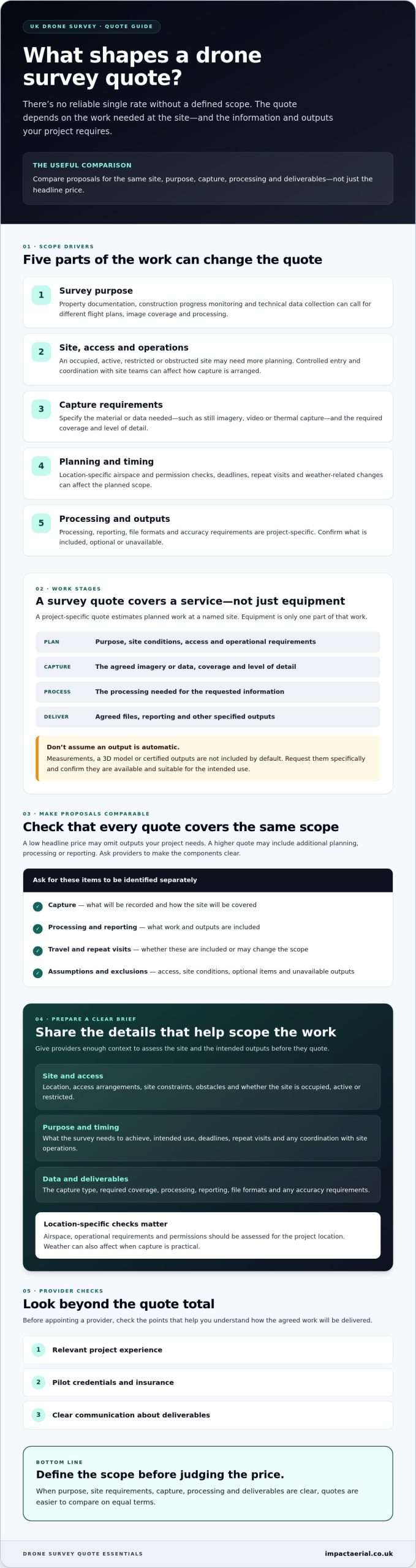
There’s no reliable single rate for a drone survey without first defining the scope. The site, the survey’s purpose, the data capture required and the processing involved determine what work a provider is being asked to deliver. As a result, the drone survey cost uk clients are quoted can vary even when projects seem similar at first glance.

A project-specific drone survey quote is an estimate for the planned work at a named site, based on the information needed and the agreed outputs. It should describe a survey service, not the purchase or operating cost of drone equipment. Equipment is only one part of the work. Planning, capture and processing also shape the scope.

A roof survey video can help illustrate the level of visual detail aerial capture may provide:

Why survey purpose changes the scope

Property documentation may focus on recording visible building conditions, while construction progress monitoring may involve capturing a site at agreed intervals. A technical data-collection project may need a different flight plan, image coverage or processing approach. The intended use matters: information for a visual review may not need the same level of detail as data intended to support a specific project decision.

Photogrammetry, the process of deriving information from overlapping photographs, is one method used to create survey data. Learn more about the science of photogrammetry. The capture plan and image quality influence what can be produced. However, a drone survey doesn’t automatically include measurements, a 3D model or certified outputs. Request these specifically and confirm they’re available and suitable for the intended use.

What a drone survey quote should describe

Before comparing proposals, check that each one identifies the same site and purpose, explains the planned capture, and lists the included deliverables. Ask the provider to distinguish confirmed outputs from optional items and anything they can’t supply. Clarify assumptions about access and site conditions so the quote reflects the work you actually need.

Data formats, accuracy levels and processing requirements can be project-specific, so confirm them directly rather than assuming they’re standard. A project consultation can help define the scope and deliverables. For a broader overview of aerial data collection, see the complete drone survey guide.

Which project factors can change a UK drone survey quote?

Survey scope grows with site complexity and the level of detail, processing and delivery the project requires. The area to cover is only one part of the picture. A compact but obstructed site may take more planning than a larger, open area. A request for processed information also involves different work from a request for basic visual capture.

For a clearer estimate, describe what the survey needs to achieve and what the team will encounter on site. A search for “drone survey cost uk” can return broad figures, but only a project-specific assessment can account for factors such as access, flight planning and deliverables.

Site access, location and operational planning

Tell the provider whether the site is occupied, active, restricted or difficult to access. Construction activity, nearby obstacles, controlled entry or the need to coordinate with site teams can affect how capture is planned. Location matters too. UK airspace and operational requirements need to be assessed for each project, rather than assumed from another site.

Weather can affect when capture is practical, so ask how weather-related changes to the plan are handled. Permissions and airspace checks are also project-specific. Providers should assess the location and consult current UK drone flight regulations rather than quote a fixed permission requirement without checking the circumstances.

Capture, processing and delivery requirements

Be specific about the material or data you need. A project might require still imagery, video, thermal capture or another defined data type. The amount of coverage, level of detail, processing, reporting and file formats can all affect the work. Ask the provider to confirm what’s available for your project, and treat unconfirmed outputs as subject to verification.

Repeat monitoring differs from a one-off visit. Capturing a site at planned intervals may involve coordinating multiple visits and keeping the capture approach consistent enough for useful comparison. Deadlines can also affect scheduling and site coordination. Explain any time constraints early, and ask the provider to identify assumptions or additional visits that aren’t included in the proposed scope.

For property or construction work, a project-specific discussion can help turn the objective into a practical capture and delivery plan. If you’re defining a survey for one of these settings, you can discuss your project scope with Impact Aerial.

Drone Survey Cost UK: What Shapes Your Quote in 2026?

How to compare drone survey quotes fairly

A fair comparison starts with a like-for-like brief. Ask each provider to quote for the same site, survey purpose, coverage and deliverables. If one proposal covers a visual record and another includes extensive processing or reporting, the headline figures don’t describe equivalent work. A lower quote may reflect a narrower scope, not better value.

Request an itemised breakdown where applicable, separating:

  • Site planning and survey capture
  • Data processing and reporting
  • Travel or site-related expenses
  • Repeat visits and any ongoing monitoring

This makes differences easier to spot and gives you a basis for focused questions before appointing a provider. For a wider overview of service types and how they’re used, read this guide to professional drone services in the UK.

Questions to ask every survey provider

Confirm who plans and conducts the flight, and ask what relevant qualifications and operational experience support the work. Check that insurance is appropriate for the project, and clarify how the provider will coordinate access and activity with your site team. For example, Impact Aerial’s pilots hold CAA GVC certification, and the company has £5m commercial liability insurance.

Also agree who can use or share the deliverables, how and when they’re expected to be supplied, and what happens if site conditions affect the plan. Ask for a written scope that lists inclusions, exclusions and assumptions. This helps prevent optional or unavailable outputs being mistaken for confirmed deliverables.

How to assess the survey outputs

Start with the decision or record the survey must support. Then check that each proposed output is relevant to that need. If you require a particular image resolution, report format or data specification, ask the provider to confirm it in writing. Don’t assume a technical output is included just because it’s possible in principle. Availability depends on the project and should be verified.

Flight duration alone is a poor measure of value. It doesn’t show the planning, coverage, processing or delivery included in the work. Compare the complete scope instead. That’s the clearest way to judge drone survey cost uk proposals on equal terms and choose a service that fits the project rather than simply selecting the lowest headline fee.

What to prepare before requesting a UK drone survey quote

A clear brief helps a provider understand the work, identify what’s still unknown and prepare a proposal around your actual requirements. You don’t need to have every technical detail settled. Explain the project in plain language, share useful site information, and ask the provider to flag assumptions before you compare quotes.

A short project brief that improves quote clarity

Use this checklist to organise your request. Include what you know, and mark anything that still needs confirming:

  • 1. Location: Give the site address or location, and describe the area or buildings to be covered.
  • 2. Purpose: State whether the work concerns a property, construction site, building or another application. Explain what you need the survey to help you understand or decide.
  • 3. Access and constraints: Note how site access is arranged and whether the site is occupied, active, restricted or subject to operational constraints.
  • 4. Schedule: Share your preferred timing, any project deadlines and whether you expect a one-off visit or repeat monitoring.
  • 5. Required outputs: Describe the coverage and deliverables you need, such as imagery or other specified data. Ask the provider to confirm which formats and outputs are available for your project.

Available plans, site maps or reference information can help explain boundaries and areas of interest. Share these if you have them, and ask the provider what formats or level of detail they need. Request that the proposal lists its assumptions and any information still required, so you can resolve gaps before agreeing the scope.

When a site consultation can help

A discussion with the provider can be useful if you’re unsure which capture approach or deliverables fit your objective. For example, a property documentation brief and a construction monitoring brief may call for different coverage and scheduling. A consultation can clarify the intended use, site conditions and outputs to consider. It doesn’t guarantee a lower quote or a particular result.

Impact Aerial provides project support from consultation through to delivery for property and construction clients across the UK. Sharing project details early can help establish a scope and identify questions to answer before a proposal is prepared. This makes it easier to assess the drone survey cost uk quotes you receive against the same requirements.

If you’re preparing a brief for a property or construction project, discuss your survey requirements with Impact Aerial.

Choosing a drone survey provider and taking the next step

A suitable provider should be able to connect the project brief to a clear operational plan and useful deliverables. Scope matters, but so does confidence that the provider understands your site, communicates clearly and has experience relevant to the work. These checks help you look beyond the headline figure when assessing drone survey cost uk proposals.

Before appointing a provider, check that the proposed capture and outputs fit your intended use. If you need a particular data format, level of detail or type of imagery, ask whether it can be supplied for your project and have the answer recorded in the proposal. Don’t assume every drone or survey service is suited to every application.

Credentials and service fit to verify

Ask who will plan and conduct the flight, what relevant pilot qualifications they hold, and whether their insurance is appropriate for the work. Check experience with similar property, construction or other project requirements, then confirm that the proposed equipment and deliverables match your brief. Impact Aerial provides UK-wide coverage, with CAA GVC certified pilots and £5m commercial liability insurance.

Equipment is one part of the solution, not a guarantee of a particular output. Confirm that the proposed capture equipment and approach suit your project, and verify the available deliverables directly with the provider before treating them as included.

Request a project-specific proposal

To help a provider assess the work, share the site location, survey purpose, preferred timeline and deliverables you’re requesting. Include access arrangements or known constraints, and say whether the work is a one-off or part of repeat monitoring. A provider may need to clarify site conditions or technical details before confirming the scope and quote.

A written proposal should make clear what work is included, what is excluded, and which details remain subject to confirmation. This gives you a sound basis for checking that the proposed scope supports your intended decision or record. Impact Aerial supports projects from consultation through to delivery, helping define scope and deliverables for property and construction work.

Ready to outline your site and requirements? Request a drone survey discussion to discuss a project-specific scope.

Set a clear scope for your next survey

The best way to assess drone survey cost uk quotes is to define the work before comparing figures. Site conditions and operational planning shape what can be captured, while processing and deliverables determine what you’ll receive. Compare proposals against the same purpose, coverage and outputs, and check what’s included or excluded.

A concise brief with the location, access details, intended use, timing and requested deliverables gives providers a stronger basis for scoping the project. Before appointing one, check relevant experience, pilot credentials, insurance and how the team will communicate about the work.

Impact Aerial provides UK-wide coverage, with CAA GVC certified pilots and £5m commercial liability insurance. A project-specific discussion can help clarify requirements for property and construction surveys, with outputs confirmed for the needs of each project.

Ready to define your survey scope? Discuss your drone survey requirements with Impact Aerial and take the next step with a clearer brief and a more informed decision.

Frequently Asked Questions

How much does a drone survey cost in the UK?

There isn’t one reliable figure without knowing the site, survey purpose, capture requirements and agreed outputs. Searches for “drone survey cost uk” may show broad estimates, but quotes can cover different work. Ask providers to price the same written scope, including any processing and reporting you need, and compare inclusions and exclusions rather than headline fees alone. Impact Aerial can discuss your project requirements before confirming a suitable scope.

What affects the cost of a drone survey?

The site, access, survey purpose and required coverage all affect the work involved. Processing, reporting and other deliverables can also change the scope, as can operational planning, timing or repeat visits. For example, a one-off site visit and ongoing construction monitoring involve different schedules. Ask the provider to list assumptions, exclusions and any additional work separately so you can understand what the proposed service covers.

Are drone surveys cheaper than traditional surveys?

Not necessarily. The comparison depends on the site, the information needed and the methods being assessed. Drone capture can be useful for aerial views, but it doesn’t automatically replace ground-based or specialist surveying. Compare providers against the same objectives, accuracy requirements, outputs and limitations. If the project requires a particular level of precision or a defined professional assessment, ask a suitably qualified surveyor which method is appropriate.

What should a drone survey quote include?

A clear quote should identify the site and objective, describe the planned capture, and specify the deliverables and any processing or reporting included. It should also set out assumptions, exclusions, access requirements, repeat visits and relevant operational considerations. Check how the outputs will be supplied and whether they suit your intended use. If a format, accuracy level or other requirement isn’t clear, ask for written confirmation before accepting.

Do UK drone surveys need CAA permission?

Requirements depend on the proposed operation, location and applicable UK aviation rules, so there isn’t one answer for every survey. The provider should assess the planned flight and relevant operational conditions rather than assume the same permissions apply across sites. Ask who is responsible for planning and compliance, and consult current Civil Aviation Authority guidance where needed. A quote alone shouldn’t be treated as confirmation that every requirement has been met.

How do I get an accurate drone survey quote?

Give providers the site location, access details, survey objective, intended use, preferred timing and required outputs. Share relevant plans or reference information if available, and say whether repeat visits may be needed. Ask each provider to confirm the scope, assumptions, inclusions and exclusions in writing. A clear brief helps them propose work that fits your project and lets you compare their quote fairly with alternatives.

Can a drone survey provide measurements or 3D models?

Some projects may include processed data or models, but these outputs aren’t standard for every drone survey. What can be supplied depends on the agreed capture method, equipment, processing and required accuracy. Don’t assume measured plans, 3D models or a specific data format are included. Describe how you intend to use the information, state any technical specifications you have, and ask the provider to confirm what’s suitable and available for your project.

Drone Progress Monitoring: Construction Tracking Guide

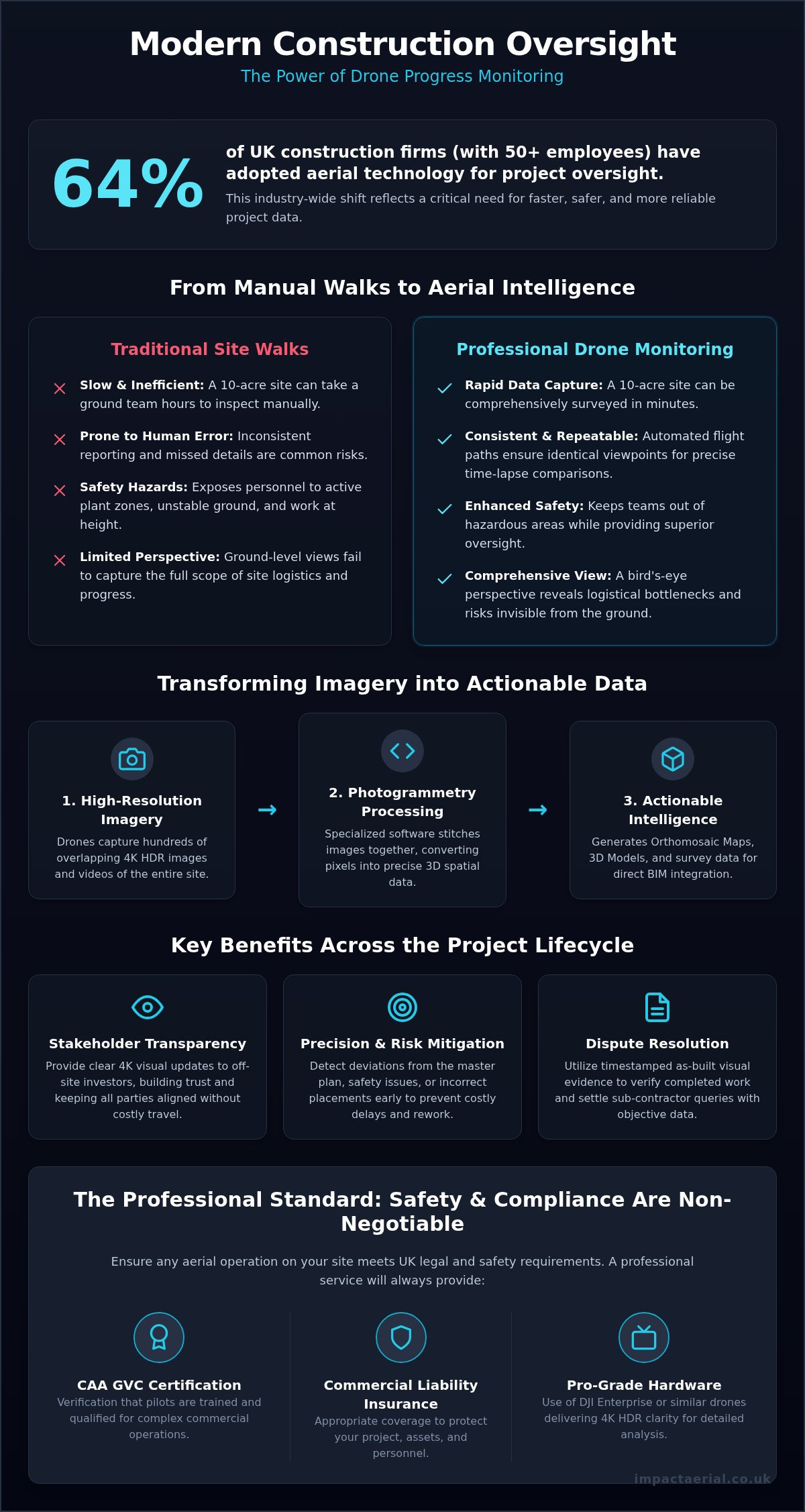
Did you know that 64% of UK construction firms with more than 50 employees now use aerial technology for project oversight? It’s a shift that reflects the industry’s need for faster, more reliable data. If you’ve spent hours on manual site walks only to find your reporting is still inconsistent or prone to human error, you’re not alone. Managing a complex build requires precision that traditional methods often struggle to provide. Integrating a professional drone for progress monitoring allows you to replace those tedious inspections with high-resolution, actionable data that keeps every stakeholder informed.

This guide explores how professional drone services provide the accurate, real-time insights needed to keep your projects on schedule and within budget. We’ll examine the transition from simple visual imagery to advanced survey data, including how digital twins and BIM integration can reduce site visit requirements for off-site stakeholders. By adopting a meticulous, safety-conscious approach to aerial data, you can detect deviations from the master plan early and mitigate risks before they become costly delays. From CAA regulations to the latest advancements in professional drone technology, we’ll cover everything you need to know about modern construction tracking.

Key Takeaways

  • Move beyond simple photography to capture repeatable site intelligence that provides a consistent record of every project phase.
  • Understand the technical transition from raw imagery to actionable survey data that integrates directly with your existing BIM workflows.
  • Utilise a drone for progress monitoring to perform precise volumetric analysis and topographical surveys, reducing the need for manual site walks.
  • Ensure project safety and legal compliance by verifying that pilots hold the correct CAA GVC certification and appropriate commercial liability insurance.
  • Discover how commercial-grade DJI Enterprise hardware delivers the 4K HDR clarity required for high-tier visual documentation and stakeholder reporting.

What is Drone Progress Monitoring for Construction?

Drone progress monitoring is far more than just taking photographs from the sky. It’s the systematic use of an Unmanned Aerial Vehicle (UAV) to capture consistent, repeatable data across a construction site. In 2026, the UK industry has moved beyond simple imagery toward true site intelligence. This technical approach uses high-frequency aerial data to establish a Golden Thread of information. This digital record is now a critical standard for maintaining safety and accountability throughout a project’s lifecycle, ensuring that every structural decision is documented and traceable.

Professional drones provide a bird’s-eye view that manual surveys cannot match. They offer a comprehensive perspective of the entire site in a single flight, allowing project managers to spot logistical bottlenecks or safety risks that remain invisible from ground level. Adopting a drone for progress monitoring ensures every phase of the build is documented with commercial-grade precision. This isn’t just about seeing the site; it’s about having a reliable, high-resolution data stream that bridges the gap between the field and the office.

To better understand how these digital models are generated, watch this practical demonstration:

The Core Advantages Over Traditional Site Walks

Manual inspections are notoriously slow and prone to human error. Efficiency is a major driver for the switch to aerial tech; a qualified pilot can survey a 10-acre site in minutes, whereas a ground team might spend hours navigating the same terrain. Safety is another non-negotiable benefit. By deploying drones, you keep personnel out of active plant zones and away from hazardous heights or unstable excavations. Consistency is the final technical advantage. Adopting a professional drone for progress monitoring allows us to use automated flight paths to ensure identical viewpoints for every visit, creating perfect time-lapse comparisons that accurately track the master plan’s execution.

Stakeholder Transparency and Communication

Effective communication is often the biggest hurdle on large-scale UK developments. Providing off-site investors and owners with 4K HDR visual updates builds immediate trust and keeps stakeholders aligned without the need for constant travel. This reduction in site visits directly supports corporate sustainability goals and reduces project overheads. Additionally, these records are vital for dispute resolution. Having visual as-built evidence allows you to verify work completed and settle sub-contractor queries with objective, timestamped data rather than hearsay.

Technical Deliverables: Transforming Imagery into Actionable Data

Raw footage provides a visual record, but it lacks the spatial accuracy required for engineering decisions. A professional drone survey bridges this gap by converting pixels into precise coordinates. Using a high-specification drone for progress monitoring equipped with 4K HDR cameras allows project teams to identify minor snags or safety issues, such as missing edge protection or incorrect rebar placement, from a desktop. This transformation of imagery into actionable data is what enables modern construction sites to operate with such high levels of oversight. It moves the conversation from ‘what does it look like’ to ‘is it built correctly’.

Photogrammetry and Orthomosaic Maps

Photogrammetry is the science of making measurements from photographs. By stitching together hundreds of overlapping aerial images, we create an orthomosaic map. This is a distortion-free, top-down view of the entire site that is geometrically corrected to be as accurate as a traditional map. These 2D deliverables are invaluable for planning site logistics, managing material storage, and tracking plant movement. They provide a clear, measurable canvas for project managers to overlay design plans and verify ‘as-built’ progress against the master schedule. Because these maps are scaled and georeferenced, you can measure distances and areas directly on the digital file with confidence.

LiDAR and 3D Point Clouds

While photogrammetry is excellent for visual site documentation, LiDAR (Light Detection and Ranging) provides a deeper level of technical insight. LiDAR sensors emit laser pulses that penetrate vegetation and scaffolding, providing hyper-accurate terrain models even in complex environments. This data is processed into 3D point clouds, which act as high-fidelity digital twins of the structure. These models allow for the early detection of deviations that would be impossible to spot on a standard site walk.

Integrating these point clouds into Building Information Modelling (BIM) workflows, often via .rvt or .ifc formats, allows for the direct overlay of 3D structural models onto real-world foundations. This level of precision is why many firms now choose professional Construction Site Monitoring to ensure their digital and physical worlds remain perfectly aligned. By using these high-accuracy data formats, you can maintain a meticulous record of every structural phase, ensuring the Golden Thread of information remains unbroken throughout the build.

Drone Progress Monitoring: Construction Tracking Guide

Strategic Applications Throughout the Project Lifecycle

Integrating a drone for progress monitoring offers a chronological record that matures alongside the project. This isn’t a one-off service but a strategic tool used from initial site appraisal to final handover. By capturing data at every major milestone, project managers maintain a continuous digital history that supports the Golden Thread of information required for modern UK developments. This ensures that every stakeholder has access to the same high-tier visual evidence at any point in the build.

In the pre-construction phase, a survey drone establishes a precise topographical baseline. This allows for accurate site planning and helps identify potential drainage or access issues before heavy machinery arrives. It ensures that the design team works with real-world elevations rather than outdated maps, reducing the risk of costly design revisions later in the schedule. Establishing this baseline is the first step in a data-centric approach to risk mitigation.

Volumetric Measurements and Earthworks

During groundworks, aerial data becomes essential for managing complex earthworks. We use photogrammetry to calculate stockpile volumes in seconds with high precision, removing the need for manual measurements on active sites. This data allows site managers to track excavation progress against design levels, which is critical for preventing over-digging and reducing expensive material waste. Improved material management ensures that cut-and-fill operations remain balanced, keeping the project on budget and ensuring plant equipment is used efficiently.

As the build moves into the structural phase, the focus shifts to monitoring steel frames, concrete pours, and facade installation. High-resolution imagery allows for the verification of structural alignment and the timing of key trades. It provides a clear record of sub-surface works before they’re covered, offering peace of mind for both contractors and clients. This transparency helps settle sub-contractor queries and ensures that work meets the specified quality standards before the next phase begins.

High-Resolution Snagging and Roof Inspections

During the final stages and handover, drones are the most efficient tool for creating comprehensive snagging lists. We use 4K zoom cameras to conduct detailed drone inspections of hard-to-reach areas like high-level cladding and roof membranes without the cost of scaffolding. This process documents the integrity of solar installations and waterproofing, creating a digital record for the O&M manual. Regular aerial audits after handover also support long-term maintenance, identifying issues like gutter blockages or thermal anomalies before they lead to structural damage.

UK Compliance: Why Professional Certification is Non-Negotiable

Operating a drone commercially in the UK is strictly regulated by the Civil Aviation Authority (CAA). For any construction firm, ensuring their provider holds a valid drone license is the first step in responsible site management. Using an unlicensed operator doesn’t just risk heavy fines; it invalidates insurance and creates significant liability for the main contractor. A professional drone for progress monitoring service must operate under a specific Operational Authorisation, which requires rigorous training and documented safety protocols.

The General Visual Line of Sight Certificate (GVC) is the industry standard for construction sites. It demonstrates that the pilot has the technical competency to handle hardware in complex, high-risk environments. Beyond the pilot’s skills, professional firms provide detailed Risk Assessments and Method Statements (RAMS) tailored to the specific hazards of an active site. This documentation ensures that aerial operations don’t interfere with cranes, plant machinery, or ground crews, maintaining a safe working environment for everyone involved.

High-value construction projects demand robust protection that consumer-grade policies cannot provide. We carry £5m commercial liability insurance as standard, providing the psychological comfort and financial security that Tier 1 contractors require. This level of coverage is a hallmark of a meticulous operator who understands the scale of modern development risks. It ensures that in the unlikely event of an incident, the project’s financial interests remain fully protected.

This comprehensive approach to risk management often extends to ground assets, where insurance approved vehicle tracker installation UK provides an additional layer of security for the high-value plant machinery used across the site.

Managing CAA Regulations in Urban Environments

Flying in congested areas like Birmingham or London requires advanced planning and strict adherence to ground safety zones. Pilots must navigate complex airspace restrictions and coordinate with local authorities when necessary. A CAA GVC certified pilot is legally required for most commercial site monitoring to ensure flights remain compliant with UK law. The pilot’s role extends beyond the controls; they manage the safety of the public and site personnel by establishing clear take-off and landing areas and maintaining a sterile flight zone.

Data Security and Privacy (GDPR)

Capturing high-resolution imagery for a drone for progress monitoring schedule near public highways or residential areas triggers strict GDPR requirements. Professional firms implement clear protocols to manage privacy concerns, such as blurring faces or car registrations when they appear in the background of site data. Secure data storage and encrypted sharing platforms are non-negotiable for sensitive project information. We ensure all data handling aligns with UK data protection laws, protecting the project’s reputation and legal standing from initial capture to final archiving.

To ensure your next project meets these rigorous safety and legal standards, partner with a CAA-certified drone specialist today.

Implementing Drone Progress Monitoring with Impact Aerial

Impact Aerial provides a managed service that removes the operational and regulatory burden from your project team. We offer bespoke schedules tailored to the specific complexity of your build, whether you require weekly, fortnightly, or monthly data captures to meet your reporting deadlines. By deploying a professional drone for progress monitoring, we ensure that your site intelligence is consistent, repeatable, and high-quality. Our use of commercial-grade DJI Enterprise hardware ensures that every aerial filming drone mission delivers superior 4K HDR output. This provides the technical clarity needed for identifying minor snags and safety issues while also creating high-end visual assets for stakeholder presentations.

Our Professional Workflow

Our professional workflow begins with a comprehensive site audit and the establishment of fixed Ground Control Points (GCPs). These physical markers are essential for achieving centimetre-level accuracy and ensuring that data captured across months or years can be perfectly overlaid for precise time-lapse comparisons. We use advanced automated flight planning to maintain identical camera angles, heights, and speeds throughout the project’s duration. This meticulous approach allows us to deliver rapid data turnarounds, providing you with ready-to-use reports and videos that integrate seamlessly with your existing project management or BIM platforms. We don’t just provide raw data; we handle the post-production and analysis to ensure you receive actionable intelligence.

Why Choose a UK-Based Specialist?

Choosing a UK-based specialist offers strategic advantages that self-service software platforms often lack. Based in the West Midlands, we provide nationwide UK coverage and possess deep local knowledge of regional airspace regulations and safety standards. You gain direct access to our senior pilots and data analysts who provide expert oversight on every flight. This human-in-the-loop approach means that your data is interpreted by specialists who understand the nuances of UK construction, rather than relying solely on automated AI algorithms. Getting started is straightforward. We begin with an initial consultation and a detailed site feasibility study to ensure the most effective data capture strategy for your specific location and project goals. You can contact our team to request a tailored aerial filming price UK for your specific project.

Advancing Site Intelligence with Professional Aerial Data

Adopting a professional drone for progress monitoring is no longer just a visual luxury; it’s a critical component of the modern construction workflow. By transitioning from simple snapshots to actionable, survey-grade data, you establish a reliable Golden Thread of information that spans the entire project lifecycle. This technical oversight improves stakeholder transparency, reduces manual site walk requirements, and ensures that deviations from the master plan are detected before they become costly delays.

Impact Aerial provides the meticulous, safety-conscious support required for high-value UK developments. Our team of CAA GVC certified pilots utilizes high-tier DJI Enterprise technology and carries £5m commercial liability insurance to ensure your project remains compliant and protected. We handle everything from automated flight planning to post-production, delivering the precise site intelligence you need to stay on schedule.

Request a Professional Site Monitoring Quote from Impact Aerial today to secure high-resolution documentation for your next build. We’re ready to help you optimize your site oversight with precision and reliability.

Frequently Asked Questions

How often should drones fly for construction progress monitoring?

Weekly, fortnightly, or monthly intervals are the industry standard. Fast-paced phases like groundworks often require weekly flights to track rapid volumetric changes and earthworks. For long-term structural builds, monthly visits are usually sufficient to provide a reliable record. Consistent scheduling is vital for creating accurate time-lapse comparisons using a drone for progress monitoring.

Are drones for progress monitoring legal in UK cities?

Yes, they’re legal provided the operator holds a valid CAA GVC and follows strict safety protocols. Urban environments like Birmingham or London require meticulous planning and detailed RAMS. We manage all airspace permissions and ground safety zones to ensure every flight remains fully compliant with UK law and doesn’t disrupt the surrounding public.

Can drone data be integrated with BIM software like Revit?

Yes, professional drone data integrates directly with BIM platforms like Revit. We provide exports in industry-standard formats such as .rvt or .ifc. This allows project teams to overlay 3D structural models onto real-world point clouds. It’s a powerful way to ensure the physical build matches the original design and identifies deviations early.

What is the accuracy of drone-based volumetric measurements?

Drone-based volumetrics provide centimetre-level accuracy when using professional-grade hardware. By establishing fixed Ground Control Points (GCPs) and using RTK-enabled drones, we achieve results that far exceed traditional manual estimates. This precision is essential for managing cut-and-fill operations and tracking material stockpiles with confidence throughout the project lifecycle.

Do I need to clear the site before a drone survey takes place?

You don’t need to clear the site or stop work during the flight. Drones are designed to document active construction environments without causing disruption to ground crews. We only require a small, sterile take-off and landing zone. Pre-flight briefings ensure that plant operators and site personnel are aware of the aerial activity.

How much does a professional drone progress monitoring service cost?

Pricing depends on site complexity, flight frequency, and the specific technical deliverables you require. Factors like the total site acreage and the choice between LiDAR or photogrammetry also influence the final investment. We recommend an initial consultation to establish a bespoke monitoring schedule that fits your project’s specific budget and reporting needs.

What happens if the weather is too poor for a scheduled flight?

Safety is our primary concern, so we don’t fly in heavy rain or high winds. If the weather exceeds the operational limits of our DJI Enterprise hardware, we simply reschedule the flight for the next available clear window. There’s typically no additional charge for weather-related delays, ensuring your project documentation remains consistent.

Is the data captured by drones secure and GDPR compliant?

Data security is managed through encrypted storage and strict handling protocols. We ensure all captures are GDPR compliant by anonymising any public faces or car registrations that appear outside the site boundary. This meticulous approach protects your sensitive project information and ensures full compliance with UK data protection laws from capture to archiving.

