
Why can two quotes for a drone survey of the same site cover very different work? The drone survey cost UK projects face depends on more than time in the air. The data you need, site conditions, access and permissions, and the processing and deliverables included can all shape the final quote.
It’s understandable to want a clear figure and confidence that nothing important is missing. A low headline price may not include the outputs your project requires, while a higher quote may cover additional planning, data processing or reporting. Comparing quotes is easier when each provider is pricing the same scope.
This guide explains the main factors that affect drone survey costs, what to check in a professional quote, and what information to provide so a provider can scope your project. It includes practical examples for property and construction work, plus ways to clarify deliverables, access arrangements and site requirements before commissioning a survey. That makes it easier to assess quotes on equal terms and request a scope suited to your project.
Key Takeaways
- There’s no reliable single rate for a drone survey cost uk without a defined scope. The purpose, site conditions and processing all influence the work quoted.
- Check whether repeat visits, deadlines or coordination with site operations could change the scope before comparing proposals.
- Ask providers to separate capture, processing, reporting, travel and repeat visits so you can see what each quote covers.
- Share the location, access details, site constraints and intended use of the survey to help providers scope the work accurately.
- Before appointing a provider, check relevant project experience, pilot credentials, insurance and how they’ll communicate about deliverables.
What determines drone survey cost in the UK?
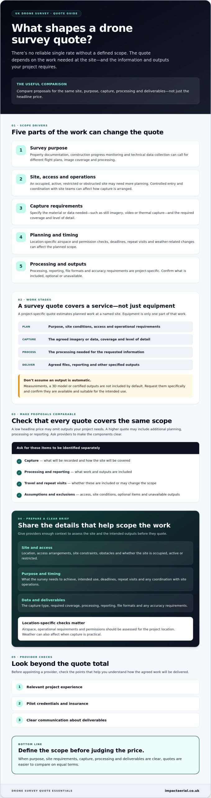
There’s no reliable single rate for a drone survey without first defining the scope. The site, the survey’s purpose, the data capture required and the processing involved determine what work a provider is being asked to deliver. As a result, the drone survey cost uk clients are quoted can vary even when projects seem similar at first glance.
A project-specific drone survey quote is an estimate for the planned work at a named site, based on the information needed and the agreed outputs. It should describe a survey service, not the purchase or operating cost of drone equipment. Equipment is only one part of the work. Planning, capture and processing also shape the scope.
A roof survey video can help illustrate the level of visual detail aerial capture may provide:
Why survey purpose changes the scope
Property documentation may focus on recording visible building conditions, while construction progress monitoring may involve capturing a site at agreed intervals. A technical data-collection project may need a different flight plan, image coverage or processing approach. The intended use matters: information for a visual review may not need the same level of detail as data intended to support a specific project decision.
Photogrammetry, the process of deriving information from overlapping photographs, is one method used to create survey data. Learn more about the science of photogrammetry. The capture plan and image quality influence what can be produced. However, a drone survey doesn’t automatically include measurements, a 3D model or certified outputs. Request these specifically and confirm they’re available and suitable for the intended use.
What a drone survey quote should describe
Before comparing proposals, check that each one identifies the same site and purpose, explains the planned capture, and lists the included deliverables. Ask the provider to distinguish confirmed outputs from optional items and anything they can’t supply. Clarify assumptions about access and site conditions so the quote reflects the work you actually need.
Data formats, accuracy levels and processing requirements can be project-specific, so confirm them directly rather than assuming they’re standard. A project consultation can help define the scope and deliverables. For a broader overview of aerial data collection, see the complete drone survey guide.
Which project factors can change a UK drone survey quote?
Survey scope grows with site complexity and the level of detail, processing and delivery the project requires. The area to cover is only one part of the picture. A compact but obstructed site may take more planning than a larger, open area. A request for processed information also involves different work from a request for basic visual capture.
For a clearer estimate, describe what the survey needs to achieve and what the team will encounter on site. A search for “drone survey cost uk” can return broad figures, but only a project-specific assessment can account for factors such as access, flight planning and deliverables.
Site access, location and operational planning
Tell the provider whether the site is occupied, active, restricted or difficult to access. Construction activity, nearby obstacles, controlled entry or the need to coordinate with site teams can affect how capture is planned. Location matters too. UK airspace and operational requirements need to be assessed for each project, rather than assumed from another site.
Weather can affect when capture is practical, so ask how weather-related changes to the plan are handled. Permissions and airspace checks are also project-specific. Providers should assess the location and consult current UK drone flight regulations rather than quote a fixed permission requirement without checking the circumstances.
Capture, processing and delivery requirements
Be specific about the material or data you need. A project might require still imagery, video, thermal capture or another defined data type. The amount of coverage, level of detail, processing, reporting and file formats can all affect the work. Ask the provider to confirm what’s available for your project, and treat unconfirmed outputs as subject to verification.
Repeat monitoring differs from a one-off visit. Capturing a site at planned intervals may involve coordinating multiple visits and keeping the capture approach consistent enough for useful comparison. Deadlines can also affect scheduling and site coordination. Explain any time constraints early, and ask the provider to identify assumptions or additional visits that aren’t included in the proposed scope.
For property or construction work, a project-specific discussion can help turn the objective into a practical capture and delivery plan. If you’re defining a survey for one of these settings, you can discuss your project scope with Impact Aerial.
How to compare drone survey quotes fairly
A fair comparison starts with a like-for-like brief. Ask each provider to quote for the same site, survey purpose, coverage and deliverables. If one proposal covers a visual record and another includes extensive processing or reporting, the headline figures don’t describe equivalent work. A lower quote may reflect a narrower scope, not better value.
Request an itemised breakdown where applicable, separating:
- Site planning and survey capture
- Data processing and reporting
- Travel or site-related expenses
- Repeat visits and any ongoing monitoring
This makes differences easier to spot and gives you a basis for focused questions before appointing a provider. For a wider overview of service types and how they’re used, read this guide to professional drone services in the UK.
Questions to ask every survey provider
Confirm who plans and conducts the flight, and ask what relevant qualifications and operational experience support the work. Check that insurance is appropriate for the project, and clarify how the provider will coordinate access and activity with your site team. For example, Impact Aerial’s pilots hold CAA GVC certification, and the company has £5m commercial liability insurance.
Also agree who can use or share the deliverables, how and when they’re expected to be supplied, and what happens if site conditions affect the plan. Ask for a written scope that lists inclusions, exclusions and assumptions. This helps prevent optional or unavailable outputs being mistaken for confirmed deliverables.
How to assess the survey outputs
Start with the decision or record the survey must support. Then check that each proposed output is relevant to that need. If you require a particular image resolution, report format or data specification, ask the provider to confirm it in writing. Don’t assume a technical output is included just because it’s possible in principle. Availability depends on the project and should be verified.
Flight duration alone is a poor measure of value. It doesn’t show the planning, coverage, processing or delivery included in the work. Compare the complete scope instead. That’s the clearest way to judge drone survey cost uk proposals on equal terms and choose a service that fits the project rather than simply selecting the lowest headline fee.
What to prepare before requesting a UK drone survey quote
A clear brief helps a provider understand the work, identify what’s still unknown and prepare a proposal around your actual requirements. You don’t need to have every technical detail settled. Explain the project in plain language, share useful site information, and ask the provider to flag assumptions before you compare quotes.
A short project brief that improves quote clarity
Use this checklist to organise your request. Include what you know, and mark anything that still needs confirming:
- 1. Location: Give the site address or location, and describe the area or buildings to be covered.
- 2. Purpose: State whether the work concerns a property, construction site, building or another application. Explain what you need the survey to help you understand or decide.
- 3. Access and constraints: Note how site access is arranged and whether the site is occupied, active, restricted or subject to operational constraints.
- 4. Schedule: Share your preferred timing, any project deadlines and whether you expect a one-off visit or repeat monitoring.
- 5. Required outputs: Describe the coverage and deliverables you need, such as imagery or other specified data. Ask the provider to confirm which formats and outputs are available for your project.
Available plans, site maps or reference information can help explain boundaries and areas of interest. Share these if you have them, and ask the provider what formats or level of detail they need. Request that the proposal lists its assumptions and any information still required, so you can resolve gaps before agreeing the scope.
When a site consultation can help
A discussion with the provider can be useful if you’re unsure which capture approach or deliverables fit your objective. For example, a property documentation brief and a construction monitoring brief may call for different coverage and scheduling. A consultation can clarify the intended use, site conditions and outputs to consider. It doesn’t guarantee a lower quote or a particular result.
Impact Aerial provides project support from consultation through to delivery for property and construction clients across the UK. Sharing project details early can help establish a scope and identify questions to answer before a proposal is prepared. This makes it easier to assess the drone survey cost uk quotes you receive against the same requirements.
If you’re preparing a brief for a property or construction project, discuss your survey requirements with Impact Aerial.
Choosing a drone survey provider and taking the next step
A suitable provider should be able to connect the project brief to a clear operational plan and useful deliverables. Scope matters, but so does confidence that the provider understands your site, communicates clearly and has experience relevant to the work. These checks help you look beyond the headline figure when assessing drone survey cost uk proposals.
Before appointing a provider, check that the proposed capture and outputs fit your intended use. If you need a particular data format, level of detail or type of imagery, ask whether it can be supplied for your project and have the answer recorded in the proposal. Don’t assume every drone or survey service is suited to every application.
Credentials and service fit to verify
Ask who will plan and conduct the flight, what relevant pilot qualifications they hold, and whether their insurance is appropriate for the work. Check experience with similar property, construction or other project requirements, then confirm that the proposed equipment and deliverables match your brief. Impact Aerial provides UK-wide coverage, with CAA GVC certified pilots and £5m commercial liability insurance.
Equipment is one part of the solution, not a guarantee of a particular output. Confirm that the proposed capture equipment and approach suit your project, and verify the available deliverables directly with the provider before treating them as included.
Request a project-specific proposal
To help a provider assess the work, share the site location, survey purpose, preferred timeline and deliverables you’re requesting. Include access arrangements or known constraints, and say whether the work is a one-off or part of repeat monitoring. A provider may need to clarify site conditions or technical details before confirming the scope and quote.
A written proposal should make clear what work is included, what is excluded, and which details remain subject to confirmation. This gives you a sound basis for checking that the proposed scope supports your intended decision or record. Impact Aerial supports projects from consultation through to delivery, helping define scope and deliverables for property and construction work.
Ready to outline your site and requirements? Request a drone survey discussion to discuss a project-specific scope.
Set a clear scope for your next survey
The best way to assess drone survey cost uk quotes is to define the work before comparing figures. Site conditions and operational planning shape what can be captured, while processing and deliverables determine what you’ll receive. Compare proposals against the same purpose, coverage and outputs, and check what’s included or excluded.
A concise brief with the location, access details, intended use, timing and requested deliverables gives providers a stronger basis for scoping the project. Before appointing one, check relevant experience, pilot credentials, insurance and how the team will communicate about the work.
Impact Aerial provides UK-wide coverage, with CAA GVC certified pilots and £5m commercial liability insurance. A project-specific discussion can help clarify requirements for property and construction surveys, with outputs confirmed for the needs of each project.
Ready to define your survey scope? Discuss your drone survey requirements with Impact Aerial and take the next step with a clearer brief and a more informed decision.
Frequently Asked Questions
How much does a drone survey cost in the UK?
There isn’t one reliable figure without knowing the site, survey purpose, capture requirements and agreed outputs. Searches for “drone survey cost uk” may show broad estimates, but quotes can cover different work. Ask providers to price the same written scope, including any processing and reporting you need, and compare inclusions and exclusions rather than headline fees alone. Impact Aerial can discuss your project requirements before confirming a suitable scope.
What affects the cost of a drone survey?
The site, access, survey purpose and required coverage all affect the work involved. Processing, reporting and other deliverables can also change the scope, as can operational planning, timing or repeat visits. For example, a one-off site visit and ongoing construction monitoring involve different schedules. Ask the provider to list assumptions, exclusions and any additional work separately so you can understand what the proposed service covers.
Are drone surveys cheaper than traditional surveys?
Not necessarily. The comparison depends on the site, the information needed and the methods being assessed. Drone capture can be useful for aerial views, but it doesn’t automatically replace ground-based or specialist surveying. Compare providers against the same objectives, accuracy requirements, outputs and limitations. If the project requires a particular level of precision or a defined professional assessment, ask a suitably qualified surveyor which method is appropriate.
What should a drone survey quote include?
A clear quote should identify the site and objective, describe the planned capture, and specify the deliverables and any processing or reporting included. It should also set out assumptions, exclusions, access requirements, repeat visits and relevant operational considerations. Check how the outputs will be supplied and whether they suit your intended use. If a format, accuracy level or other requirement isn’t clear, ask for written confirmation before accepting.
Do UK drone surveys need CAA permission?
Requirements depend on the proposed operation, location and applicable UK aviation rules, so there isn’t one answer for every survey. The provider should assess the planned flight and relevant operational conditions rather than assume the same permissions apply across sites. Ask who is responsible for planning and compliance, and consult current Civil Aviation Authority guidance where needed. A quote alone shouldn’t be treated as confirmation that every requirement has been met.
How do I get an accurate drone survey quote?
Give providers the site location, access details, survey objective, intended use, preferred timing and required outputs. Share relevant plans or reference information if available, and say whether repeat visits may be needed. Ask each provider to confirm the scope, assumptions, inclusions and exclusions in writing. A clear brief helps them propose work that fits your project and lets you compare their quote fairly with alternatives.
Can a drone survey provide measurements or 3D models?
Some projects may include processed data or models, but these outputs aren’t standard for every drone survey. What can be supplied depends on the agreed capture method, equipment, processing and required accuracy. Don’t assume measured plans, 3D models or a specific data format are included. Describe how you intend to use the information, state any technical specifications you have, and ask the provider to confirm what’s suitable and available for your project.
 2 Norton Drive, Wythall, Birmingham, B47 6HH Company registration number: 11138586. VAT Number: 366 9068 55


