
Aerial filming UAV services for TV and feature films

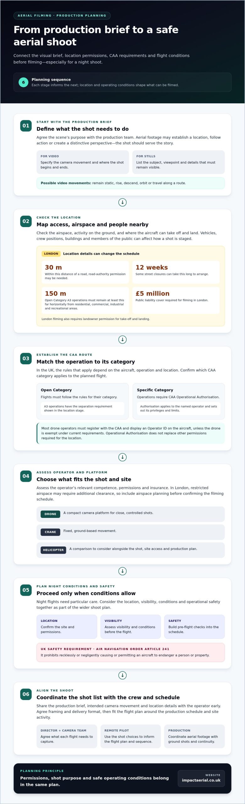
Night-time aerial filming with a UAV can be planned, but a flight should proceed only when the location, airspace, visibility and safety conditions allow. The shoot also needs close coordination with the production team so the footage serves the scene and fits the schedule.

That balance matters: aerial footage can bring distinctive perspectives to television programmes and films, but safe, usable results depend on preparation as much as camera work. Night shoots call for particular care, so the flight plan, conditions and production needs must be considered together.

This guide explains how aerial filming supports photography and video production, what to consider for night flights, and how pre-flight planning shapes a practical shoot. It also covers equipment, location requirements and operational decisions, helping you prepare before adding UAV footage to a production.

Key Takeaways

  • Plan permissions around the location, airspace and take-off and landing arrangements before setting a filming date.
  • Match the aerial shots to the production’s visual brief, from establishing views to specific photographic or video sequences.
  • Night flights need careful consideration of conditions, visibility and operational safety as part of the wider shoot plan.
  • Build pre-flight checks into the schedule: the UK Government’s Air Navigation Order article 241 prohibits recklessly or negligently causing or permitting an aircraft to endanger a person or property.

Do you take aerial photographs?

Yes. Aerial photographs can support campaign imagery, public relations and marketing, while drone video can capture moving shots for broadcast or film. In the UK, the CAA rules that apply depend on the aircraft, operation and location.

For a commercial shoot, plan around the airspace, people nearby, and take-off and landing locations. Most drone operators must register with the CAA and display an Operator ID on the aircraft, unless the drone is exempt under current requirements. Open Category flights must follow their category rules; Specific Category operations require CAA Operational Authorisation.

Location affects permissions. In London, flights within 30 metres of a road may need road-authority permission, and some street closures can take 12 weeks to arrange. Open Category A3 operations must remain at least 150 metres horizontally from residential, commercial, industrial and recreational areas. Filming in London also requires landowner permission for take-off and landing, and at least £5 million public liability cover is required.

Broadcast and Film Production

For television, commercials, drama and feature films, aerial footage can establish a location, follow action or give a scene a distinctive perspective. Share the production brief, intended camera movement and location details with the operator early, so they can inform the flight plan and shot sequence.

Campaign and PR teams can use still images in press materials, while marketing productions may need coordinated stills and video. Agree the framing and delivery format with the production team before the operation. Commercial aerial filming is one civilian use of drones; property imagery and site records are other applications, each shaped by the purpose and setting of the flight.

Operator and Aircraft Choices

When hiring a UK operator, establish which CAA category applies to the planned flight, then assess the operator’s relevant competence, permissions and insurance. A CAA Operational Authorisation applies to the named operator and sets out its privileges and limits; it does not replace other permissions required for the location.

Compared with helicopters, drones can provide a compact camera platform for close, controlled shots; cranes provide fixed, ground-based movement. The right option depends on the shot, site access and production plan. In London, restricted airspace may require additional clearance, so include airspace planning before confirming the filming schedule.

Aerial filming for television, commercials, drama and feature films

For a television programme, a drone can show how a location connects with its surroundings. In a drama, a controlled approach towards a building can establish the setting before the next scene. Commercials may use a moving aerial view to introduce a product, venue or landscape. The shot should serve the story, not simply add height.

Aerial cinematography starts with the production brief. Identify the scene’s purpose, the required camera movement and where the shot begins and ends. A wide coastline view needs different framing from a tracking shot above a road or a slow reveal over a film set. Share these choices with the remote pilot before the shoot, then fit the flight plan around the production schedule and location.

Commercial filming is one civilian use of unmanned aircraft. Other uses include capturing campaign stills or recording a site for visual documentation. In broadcast and film, the aircraft’s movement, camera angle and background all affect how footage edits alongside ground-based shots. A practical shot list helps the director, camera team and pilot agree what each flight needs to capture.

Airspace and activity on the ground also shape the shoot. Vehicles, crew positions, buildings and members of the public can affect where an aircraft can fly and how a shot is staged. In the UK, CAA rules apply to the drone operation, while location permissions may also be needed. Include these considerations in production planning rather than leaving them until the last minute.

For a production brief that calls for specialist aerial images or footage, professional aerial filming and photography can help turn the intended shots into a coordinated filming plan.
Aerial filming UAV services for TV and feature films

Aerial photography and videography

Aerial photography and video serve different production needs. A still image can provide a campaign’s lead visual, document a property from above or show how a site fits its surroundings. Moving footage can create a sense of direction, revealing a building as the camera passes it. Define the intended use first, then plan the framing and movement around it.

For aerial still photography, give the drone pilot a concise shot list. Include the subject, preferred viewpoint and details that must remain visible, such as an entrance, roofline or surrounding landscape. A high, wide frame can establish context; a lower oblique angle can emphasise a building’s shape. The pilot can then plan a safe position and camera direction for each image.

Drone photography uses an unmanned aircraft, allowing the pilot to position the camera without placing a photographer in the air. But this does not remove the need to plan permissions and the flight operation. The CAA category, location, airspace and people nearby all shape what is practical. For commercial property imagery, agree which elevations and site features the final record must show.

For video, specify whether the shot should remain static, rise, descend, orbit or travel along a route. A slow reveal of a building, for example, may need a clear start and end point to make the movement useful in the edit. Coordinate the shot with ground-based photography and filming so changes in light or site activity do not disrupt continuity.

Before the flight, confirm the shot list, permissions, intended use and delivery requirements with the production team. Separate still-image needs from video requests, and identify essential views. This gives the drone pilot a clear brief and helps the aerial photography serve its purpose, whether for a campaign, production or visual site record.

Flight planning and pre-flight inspections

Plan each mission around its location, airspace, intended shots and people nearby. A practical sequence is to assess the site, prepare the flight plan, inspect the aircraft and review conditions before flying.

Flight Plans and Location Feasibility

Start by identifying the launch and landing points, planned route, obstacles and areas where the public may be present. Check airspace restrictions and location permissions, then decide whether the proposed flight can be carried out safely within the operation’s limits. Flight-planning software can help map routes and record site constraints. Intelligent modes may support repeatable camera movements, but pilots remain responsible for managing the flight.

Pre-Flight Inspections and Risk Assessments

Before take-off, inspect the aircraft, propellers, battery, camera and control equipment for damage or faults. Compare the actual site with the risk assessment, including nearby people, vehicles and changes to the planned operating area. The Air Navigation Order article 241 prohibits recklessly or negligently causing or permitting an aircraft to endanger a person or property, according to the UK Government. Drone operators should not proceed if safety concerns remain.

Weather and Flight Conditions

Review wind, precipitation, cloud and visibility before each flight, then reassess if conditions change. One example pre-flight checklist recommends a precipitation chance below 10%, wind under 15 knots, a cloud base of at least 500 feet and visibility of at least 3 statute miles. These are checklist recommendations, not a universal forecast for every mission. Conditions at the location and the aircraft’s limits inform the pilot’s decision.

For a site-focused operation, explore commercial property drone surveys as part of planning aerial work.

Impact Aerial: Aerial Filming and Photography

Impact Aerial provides Aerial Filming and Photography for productions, campaigns and projects that need professional aerial images or video. Its CAA GVC certified pilots use commercial-grade professional drones equipped with 4K HDR cameras, backed by £5m commercial liability insurance.

Turn to Impact Aerial when you have a defined shot list, filming location or visual brief and need aerial capture planned around the project. The team also provides related services, including Drone Commercial Property Surveys, Construction Site Monitoring and PV Solar Farm Thermal Surveys.

Share your intended shots, location and production needs to discuss how aerial filming and photography could support your project. Contact Impact Aerial for a free, no-obligation quote.

Shape your next shoot around the story

The strongest next step is to turn your creative idea into a clear visual brief. Decide what viewers should notice, where the footage will appear, and how aerial filming with a UAV will support the wider production. A defined purpose helps the aerial material feel considered and gives the production team a useful starting point for shot planning and editing.

Impact Aerial provides Aerial Filming and Photography, alongside PV Solar Farm Thermal Surveys and Drone Commercial Property Surveys. These services support different project needs, from creating visual content to capturing property or solar-site information. When you get in touch, outline the project location, intended use and key requirements.

Contact Impact Aerial to discuss your project and plan a practical next step. A well-shaped brief can help your team move forward with confidence.

Frequently Asked Questions

Can you fly at night?

Yes, night flights can be planned when the operator can meet applicable aviation rules and safe operating conditions. An aerial-filming UAV plan should account for visibility, the launch and landing area, airspace, nearby activity and crew coordination. For example, a production filming after dark should agree shot positions and communication procedures before take-off, rather than adapting the plan mid-flight.

Can you fly over water?

Yes, a drone can be used for aerial filming over water when the route and recovery plan suit the location. The pilot should consider where the aircraft can take off and land, how far the shot extends from shore, and how to end the flight safely if the plan needs to change. Water reflections can also affect exposure, so test framing and camera settings before recording key footage.

How does weather affect flight operations?

Weather affects flight conditions and the quality of footage. Wind can make a planned camera movement less steady, while rain can affect visibility and equipment. Before a coastal shoot, for example, review the local forecast and observe conditions at the launch site. Reassess if the weather changes and adapt the shot plan to the conditions.

How long can you fly for?

Flight time depends on the aircraft, battery condition, weather, route and camera workload. A close, simple shot may need a different plan from a longer tracking sequence across a site. Plan each mission around the required footage, allowing for positioning and a safe return. For a production, divide a complex sequence into separately planned shots rather than relying on one uninterrupted flight.

How much do you charge?

The price depends on the project and is provided after a quote request. Factors include the location, filming requirements, operational planning and any post-production work needed. A straightforward set of still images has different requirements from a multi-shot film sequence involving several locations. Impact Aerial offers a free, no-obligation quote, so you can outline the intended use and receive project-specific pricing.

How safe is it?

Safe operation depends on planning, competent piloting and responding to conditions at the location. For example, a filming site with moving vehicles or members of the public needs clear separation from the aircraft’s operating area. The pilot assesses risks before flight and monitors the operation as it progresses. If site conditions change, the plan should be adjusted to protect people and property.
Professional Sky Services: The Ultimate Guide to Drones in Business

The world of commercial drones offers incredible opportunities, yet navigating this new landscape can be daunting for any business. You may be wondering what’s truly possible, how to distinguish between cinematic filming and technical surveys, or-most importantly-how to ensure you’re hiring a safe and legally compliant operator. Understanding the full spectrum of professional sky services is the first step towards leveraging this technology effectively. It’s not just about flying a drone; it’s about deploying a powerful tool for data collection, marketing, and operational efficiency with complete confidence.

In this ultimate guide, we demystify the industry for you. We will break down the key categories of professional drone services, from breathtaking aerial videography to precision-based 3D modelling and structural inspections. You will learn how to identify the right service for your specific project, understand the critical importance of CAA GVC certification and commercial liability insurance, and gain the confidence to select a provider that offers not just top-quality results, but complete peace of mind. Discover how to unlock the cost savings, improved safety, and superior data that professional drone operations can bring to your business.

Defining Sky Services: A Modern Perspective on Aerial Operations

When we discuss professional sky services, we are referring to a sophisticated range of commercial operations conducted using advanced drone technology. It’s important to clarify that this is entirely distinct from the telecommunications and media company, Sky Group Ltd. Our focus is on leveraging the capabilities of the modern Unmanned Aerial Vehicle (UAV) to capture high-resolution data and imagery from the air. This technology forms the backbone of a new era in aerial work, offering precision, safety, and efficiency that was once unimaginable.

To see these services in action, the video below offers a glimpse into the world of professional drone operations:

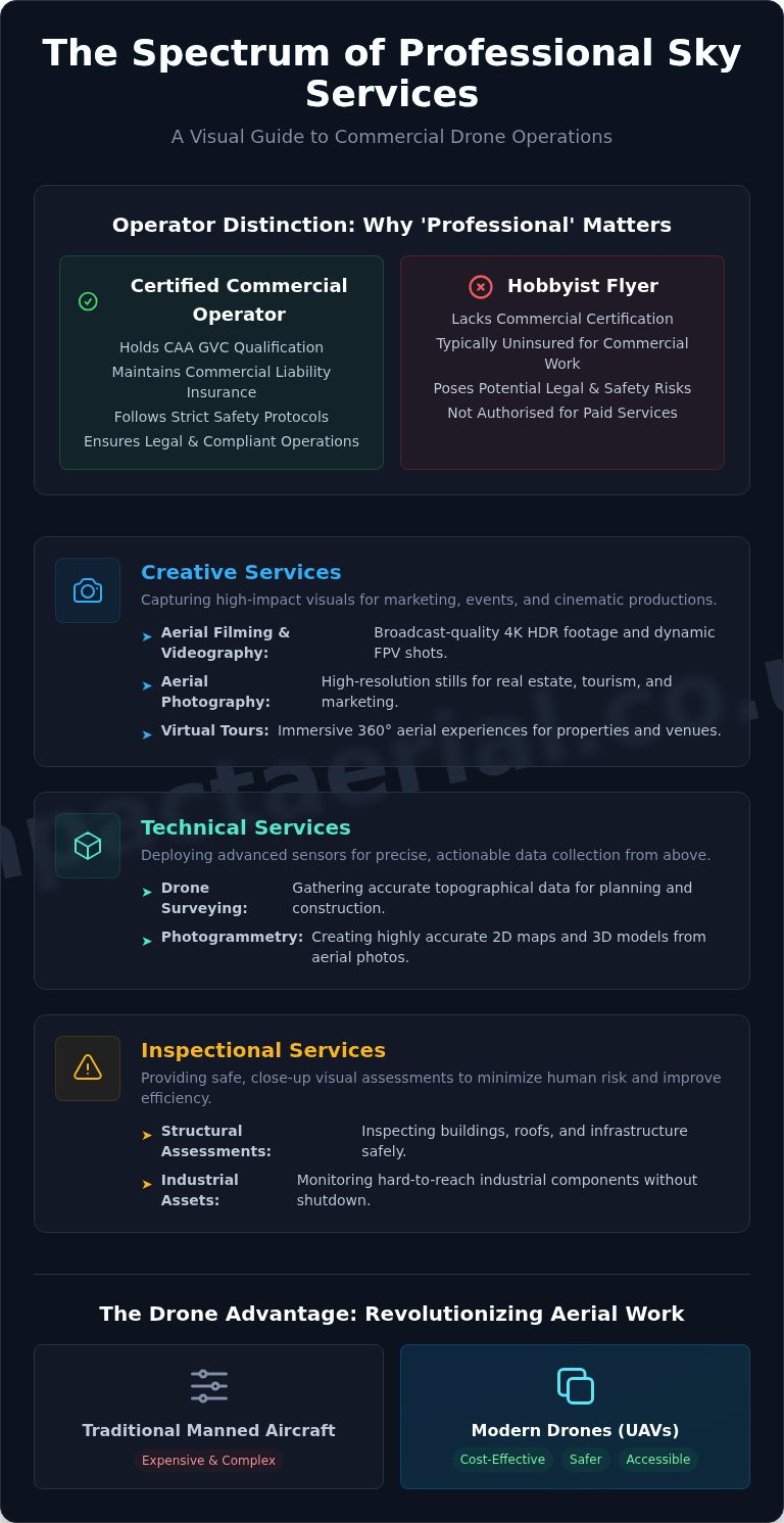
These services can be broadly categorised into three main areas. Creative services include cinematic aerial filming and photography for marketing and events. Technical services involve precise data-gathering for applications like photogrammetry and 3D modelling. Finally, inspectional services provide safe, close-up visual assessments of buildings, infrastructure, and industrial assets, minimising risk to human life.

The Evolution from Manned Aircraft to Drones

Historically, aerial data capture required the use of expensive and logistically complex manned aircraft like helicopters or planes. Drones have revolutionised this landscape by offering a safer, more accessible, and highly cost-effective alternative. This shift has democratised access to top-quality aerial perspectives, enabling businesses of all sizes to benefit from data and visuals that were previously reserved for large-scale productions or major civil engineering projects.

Why ‘Professional’ Matters: Hobbyist vs. Commercial Operator

The distinction between a hobbyist flyer and a certified commercial operator is critical. Professional sky services are governed by strict regulations set by the UK’s Civil Aviation Authority (CAA). A commercial operator must hold a GVC (General Visual Line of Sight Certificate), undergo rigorous training, and maintain comprehensive commercial liability insurance. This framework ensures that all operations are conducted safely and legally, providing clients with the essential peace of mind that their project is in expert hands.

Creative Sky Services: Capturing High-Impact Visuals

Beyond technical inspections and surveys, our professional sky services offer transformative creative potential for businesses across the UK. Drones provide a unique vantage point, capturing high-impact visuals that were once prohibitively expensive or simply impossible. While aerial photography captures stunning, high-resolution still images to provide context, aerial videography brings these perspectives to life with dynamic motion. Adherence to strict operational standards, such as those mandated by the UK’s Civil Aviation Authority (CAA), is paramount for any creative flight. Understanding the global regulatory landscape, including the comprehensive FAA regulations for commercial drones in the US, further highlights why choosing a certified, knowledgeable operator is crucial for project success and safety.

Aerial Filming & Videography

Our creative sky services deliver broadcast-quality footage for promotional videos, television, and cinematic productions. Utilising the latest 4K HDR cameras, we produce crystal-clear, vibrant visuals that command attention. For dynamic sequences, we deploy cinematic FPV (First Person View) drones to fly through structures and follow moving subjects with unparalleled agility. This technology enables breath-taking shots that immerse the viewer in the action. Every project benefits from professional post-production, including colour grading and editing, to ensure a polished final cut.

To see how we bring cinematic vision to life, explore our dedicated Aerial Filming services.

Aerial Photography for Business

For industries like commercial real estate, tourism, and event management, a single aerial photograph can convey more than a dozen ground-level shots. Our high-resolution images showcase properties in their entirety, highlighting key features, boundaries, and surrounding amenities. This elevated perspective provides essential context and a sense of scale, giving potential buyers or visitors a complete and compelling overview. These visuals are invaluable assets for marketing brochures, websites, and planning documents.

View examples of our work in our Drone Photography portfolio.

Virtual Tours and Immersive Experiences

We elevate property and venue marketing by creating fully interactive 360-degree virtual tours from the air. By capturing a series of panoramic images, we stitch together an immersive digital experience that allows users to explore a location from a unique aerial viewpoint. This technology is particularly effective for construction site progress monitoring, hospitality showcases, and large-scale property listings, offering stakeholders a detailed and engaging way to interact with a site from anywhere in the world.

Technical Sky Services: Precision Data from Above

Beyond capturing stunning visuals, our drones are sophisticated data-gathering platforms. We deploy advanced sensor technology to provide industries with precise, actionable intelligence from an aerial perspective. These technical sky services transform how businesses approach surveying, asset management, and safety compliance, delivering significant gains in both efficiency and accuracy across sectors like construction, energy, and infrastructure management.

Drone Surveying and Photogrammetry

Photogrammetry is the science of creating highly accurate 3D models and maps from overlapping aerial photographs. Our CAA-certified pilots conduct meticulous flights to capture data that is then processed into valuable outputs. This includes detailed orthomosaic maps for site planning, digital elevation models (DEMs) for terrain analysis, and precise stockpile volume calculations for the construction and quarrying industries, eliminating hazardous and time-consuming manual measurements.

Aerial Inspections for Safety and Maintenance

The foremost benefit of using drones for asset inspection is the dramatic improvement in safety. By deploying unmanned aerial vehicles (UAVs), we remove the need for personnel to work at height, operate near live electrical components, or access structurally compromised areas. Our services cover detailed inspections of:

  • Building facades and roofing systems
  • Telecommunication towers and wind turbines
  • Bridges, railways, and other critical infrastructure

This remote approach not only mitigates risk but also minimises operational downtime and reduces costs associated with scaffolding or rope access teams.

Specialised Surveys: Thermal and Agricultural

Equipped with radiometric thermal cameras, our drones can detect temperature variations invisible to the naked eye. This capability is invaluable for solar farm inspections, quickly identifying malfunctioning panels, and for conducting building heat loss surveys to improve energy efficiency. In agriculture, multispectral sensors allow us to monitor crop health, identify irrigation issues, and help farmers optimise yields with targeted interventions.

Our commitment to delivering top-quality data is underpinned by a rigorous adherence to operational standards. This professional approach is a global benchmark; just as commercial operators in the United States must follow strict FAA Part 107 Guidelines, our operations are fully compliant with UK Civil Aviation Authority regulations. To learn more about how our detailed data can benefit your project, explore our Commercial Drone Surveys.

Professional Sky Services: The Ultimate Guide to Drones in Business

Choosing a Sky Services Provider: A Checklist for Success

In a niche but increasingly diverse market, selecting the right drone operator is paramount to the success and safety of your project. Commissioning illegal or unqualified pilots exposes your business to significant liability and risk. This straightforward checklist provides the essential criteria for vetting a professional provider, ensuring your chosen partner for sky services operates with the highest standards of safety, legality, and technical expertise.

Essential Legal & Safety Requirements

Before discussing project specifics, a provider must meet these non-negotiable legal and safety benchmarks. Failure to produce any of this documentation is an immediate red flag.

  • CAA GVC Certification: The pilot must hold a valid General Visual Line of Sight Certificate (GVC) issued by the Civil Aviation Authority (CAA). This is the current UK legal requirement for most commercial drone operations and proves the pilot is trained in safe flight procedures. For more detail, you can review the official UK Drone Laws.
  • Commercial Drone Insurance: For your peace of mind, verify they hold specialist commercial drone insurance with a minimum of £5 million in public liability coverage. Ask to see a current certificate of insurance.
  • Risk Assessment Method Statements (RAMS): A professional operator will always conduct a thorough pre-flight survey and provide a detailed RAMS document. This is a clear sign of a meticulous and safety-conscious approach to every operation.

Evaluating Equipment and Expertise

Once legal compliance is established, you can assess if the company has the right tools and experience to deliver the high-quality results your project demands. A capable provider will be transparent about their technology and proud to showcase their work.

  • Professional Drone Fleet: Ask about the drones they use. A leading provider will operate a fleet of commercial-grade aircraft, such as the DJI Enterprise series, equipped for specific data-gathering tasks.
  • High-Quality Payloads: Enquire about camera quality (e.g., 4K HDR video) and whether they offer specialised sensors like thermal imaging for detailed inspections or LiDAR for advanced surveying.
  • Relevant Industry Experience: The most crucial step is to ask for a portfolio or case studies relevant to your sector. Proven experience in construction, surveying, or commercial property demonstrates they understand your specific challenges and can deliver breath-taking, actionable results.

Following this checklist will help you confidently select a competent and professional partner. For a complete overview of what to look for, see our guide on How to Hire a Drone Pilot. At Impact Aerial, we pride ourselves on transparency and exceeding industry standards. See our credentials and commitment to safety.

Partnering for Success: The Future of Your Aerial Strategy

As we’ve explored, the potential of drone technology is vast and transformative. From capturing breathtaking marketing visuals to gathering precise data for inspections and surveys, professional sky services offer a significant competitive advantage. The key to unlocking this potential lies not just in the technology itself, but in partnering with a provider who combines technical expertise with a deep commitment to safety and regulatory compliance.

At Impact Aerial, our experience across the Construction, Property, and Marketing sectors is backed by the highest industry standards. Our pilots are fully CAA GVC Certified and insured, providing you with complete peace of mind. By utilising state-of-the-art 4K HDR DJI Enterprise drones, we deliver top-quality, actionable insights tailored to your specific objectives.

Ready to see your project from a new perspective? Discuss your project with our certified aerial experts today. Take the first step towards elevating your business operations and achieving unparalleled results.

Frequently Asked Questions

What are the main types of professional sky services available?

Professional sky services encompass a wide range of data-gathering and media creation applications. Key services include high-resolution aerial photography and 4K videography for marketing and events. We also specialise in technical services like thermal imaging inspections for detecting heat loss, detailed roof and building surveys for maintenance, and advanced photogrammetry to create accurate 3D models and orthomosaic maps for construction and land management.

How much do professional drone services typically cost in the UK?

The cost of professional drone services in the UK varies based on project complexity, risk, and required deliverables. A straightforward half-day aerial photography project might start from £300-£500. However, more complex survey work requiring specialist equipment, extensive pre-flight planning, and detailed data processing will be quoted on a project-by-project basis. We always provide a detailed, transparent quote outlining all costs before any work commences.

What is the difference between a hobby drone pilot and a certified commercial operator?

The primary difference is legal and professional accountability. A certified commercial operator holds a CAA-issued Operational Authorisation (such as a GVC), undergoes rigorous training in flight safety and regulations, and carries comprehensive commercial liability insurance. Hobbyists operate under a different, more restrictive set of rules and cannot legally fly for commercial gain. Hiring a certified professional ensures your project is conducted safely, legally, and with complete peace of mind.

What industries benefit most from using sky services like drone surveys?

A diverse range of industries leverage professional sky services for efficiency and safety. The construction and engineering sectors use drone surveys for site monitoring and asset management. Estate agents and property developers benefit from compelling aerial marketing materials. Furthermore, building management and roofing companies rely on drones for safe, high-access inspections, while the agricultural sector uses them for crop health analysis and land mapping.

How do I verify if a drone company is legally certified by the CAA?

Any legitimate commercial drone operator in the UK must hold a valid Operational Authorisation issued by the Civil Aviation Authority (CAA). You should always ask to see a copy of this certificate before commissioning any work. For added assurance, you can also check for membership in professional bodies like the Drone Safe Register or ARPAS-UK, which vet their members to confirm they hold the correct certifications and insurance.

What kind of deliverables can I expect from an aerial filming or survey project?

Deliverables are tailored to your project’s specific goals. For creative projects, you can expect professionally edited, high-resolution 4K video clips and high-quality still photographs. For technical surveys and inspections, deliverables typically include detailed PDF reports with annotated imagery, orthomosaic maps, 3D point cloud data for use in CAD software, and digital elevation models (DEMs). We discuss all output formats with you during the initial consultation.