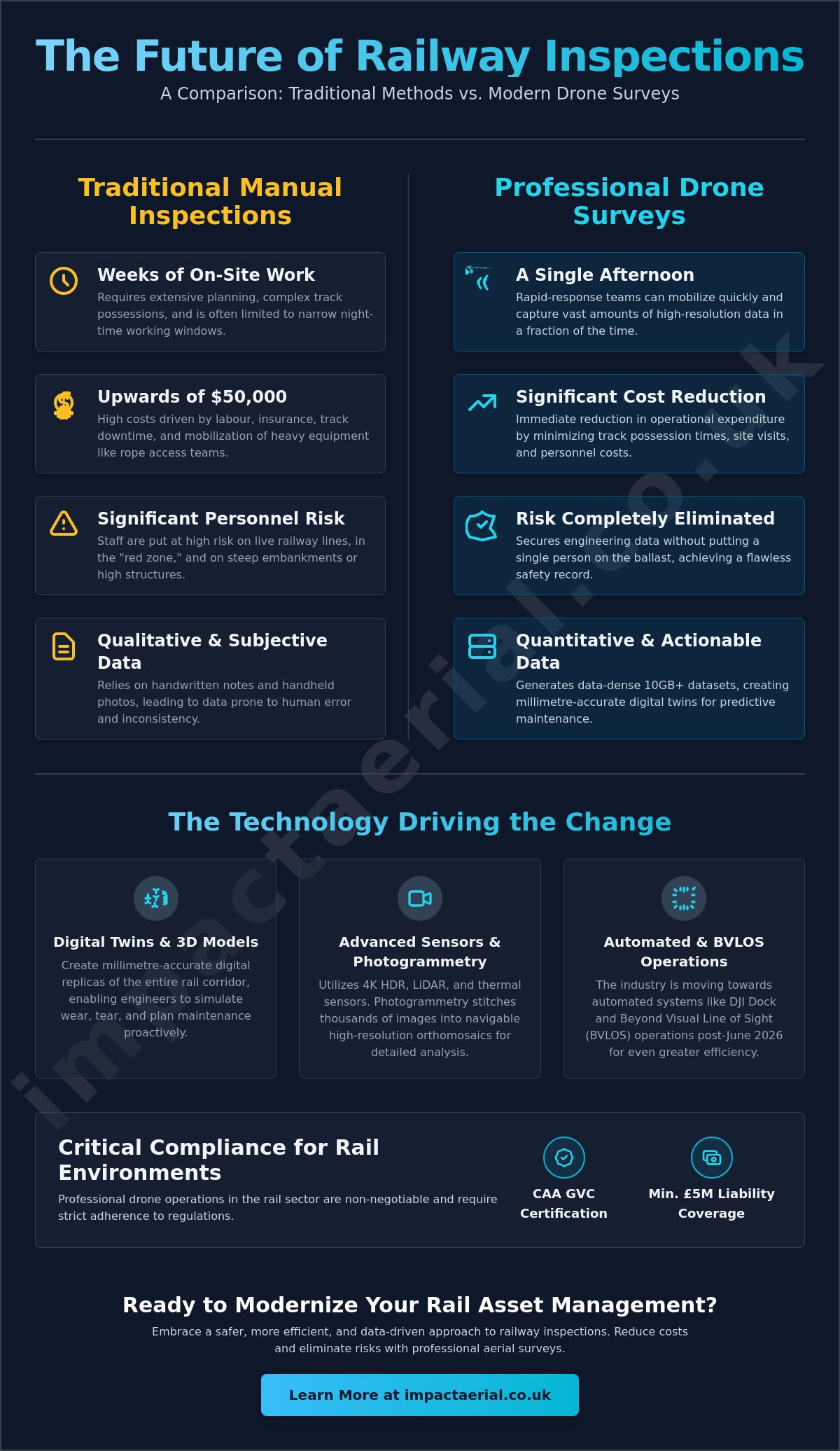
A manual bridge inspection can take weeks and cost upwards of $50,000, yet a professional drone survey for railway inspections can often complete the same high-resolution data capture in a single afternoon. Traditional rail asset management frequently demands complex track possessions and puts staff at significant risk on live lines, creating a logistical bottleneck for maintenance schedules. You’re likely all too familiar with the cost of track downtime and the inherent danger of putting personnel in high-risk environments just to gather basic structural data.
It’s clear that the industry is shifting toward a more data-centric, safety-first approach. By leveraging professional aerial technology, operators can now secure millimetre-accurate engineering data without putting a single person on the ballast. This transition is no longer experimental; it’s a mandatory shift for those who prioritize precision and regulatory compliance. This guide provides an authoritative overview of how drones are revolutionising rail asset management. You’ll discover the impact of the June 2026 Beyond Visual Line of Sight (BVLOS) policy changes, the deployment of automated docking systems like the DJI Dock 3, and the technical standards required to maintain a flawless safety record while significantly reducing operational costs.
Key Takeaways
- Understand how a professional drone survey for railway inspections enables proactive asset management through the creation of high-fidelity digital twins and 3D corridor models.
- Learn about the transition from manual, qualitative reports to data-dense 10GB datasets using 4K HDR sensors and advanced photogrammetry.
- Discover why aerial surveys reduce track downtime and eliminate the safety risks associated with putting staff on live rails.
- Identify the critical regulatory and insurance requirements, including CAA GVC certification and minimum £5m liability coverage, necessary for rail environments.
- Explore the logistical advantages of rapid-response drone teams capable of mobilising faster than traditional rope access or heavy plant equipment.
The Evolution of Railway Inspections: Why Drones are Essential in 2026
In 2026, the definition of asset management has fundamentally changed. Aerial rail inspection involves the deployment of an Unmanned aerial vehicle (UAV) to capture high-resolution imagery and granular sensor data of tracks, embankments, and critical infrastructure. This technology has facilitated a critical shift from reactive maintenance, where repairs happen after a fault is found, to proactive asset management using digital twins. By creating a millimetre-accurate digital replica of the rail corridor, engineers can simulate wear and tear before it impacts service.
The deployment of a drone survey for railway inspections is now the primary data source for many operators. Traditional manual walkouts haven’t disappeared, but they’ve evolved into a secondary verification method. Instead of staff spending hours on live tracks for routine checks, they only enter the “red zone” to address specific issues identified by the drone. This significantly reduces staff exposure to live tracks and improves the overall safety record of the inspection team.
To better understand how this technology is applied in the field, watch this video of a railway survey project:
Challenges of Traditional Manual Rail Inspections
Traditional methods present a constant logistical nightmare. Securing track possessions often requires months of planning and narrow night-time working windows that limit the scope of what can be inspected. Beyond logistics, manual reporting is prone to human error and subjectivity. An engineer’s handwritten notes or handheld photos don’t provide the objective, repeatable digital data that modern systems require. Inspecting steep embankments or high-bridge structures manually carries immense physical risk and often requires expensive rope access teams or heavy plant machinery that’s slow to mobilise.
The ROI of Aerial Rail Monitoring
The financial argument for aerial monitoring is undeniable. By reducing possession times and the frequency of site visits, operators see an immediate reduction in operational expenditure. A drone survey for railway inspections can identify ballast issues or track fatigue months before they lead to a catastrophic failure or an unplanned line closure. The real value lies in long-term data trending. By comparing 2026 survey data with previous datasets, asset managers can perform predictive maintenance with a level of accuracy that was previously impossible. This methodical approach ensures that every pound spent on maintenance is targeted where it’s needed most.
Technical Capabilities: Sensors and Data for Modern Rail Assets
A professional drone survey for railway inspections produces more than just aerial photographs. It generates a comprehensive, multi-layered data suite that serves as the foundation for modern maintenance. By deploying a variety of sensors, from 4K HDR visual cameras to LiDAR and thermal arrays, operators capture high-density datasets that manual walkouts simply cannot replicate. This shift moves the industry away from qualitative “best guesses” toward quantitative, repeatable engineering facts. It’s about turning raw pixels into actionable insights for the permanent way.
High-Resolution Visual Inspection & Photogrammetry
High-fidelity visual data is the cornerstone of structural assessment. Modern sensors capture the minute detail of rail clips, sleepers, and fasteners with millimetre-level precision. This isn’t just about identifying a missing bolt; it’s about using photogrammetry to stitch thousands of images into a single, navigable high-resolution orthomosaic. According to the International Union of Railways, these digital advancements are vital for maximizing line capacity while ensuring absolute safety. These datasets allow for the creation of digital twins. Remote engineering teams can then perform crack propagation analysis or head wear measurements from the safety of the office. This creates a permanent, time-stamped record of the asset’s condition that can be audited at any time.
Thermal and Multi-Spectral Analysis
Thermal imaging adds a critical layer of preventative insight. By identifying thermal anomalies in overhead lines and electrical substations, teams can detect overheating components before they reach critical failure. This level of detail is now a standard component of a professional drone survey workflow. Beyond the tracks, multi-spectral sensors monitor slope stability. They detect subtle changes in soil moisture levels that might indicate drainage issues or potential landslips long before they are visible to the naked eye. This allows for targeted intervention before a minor drainage problem becomes a major operational disruption.
LiDAR and Clearance Monitoring
LiDAR technology completes the technical picture by providing accurate clearance monitoring. It maps vegetation growth against the track with laser precision, ensuring that clearance zones remain compliant with strict safety standards. Unlike manual measurements, LiDAR creates a full 3D point cloud of the rail corridor. This allows engineers to measure distances between the track and surrounding structures with absolute confidence. This data-centric approach ensures that every maintenance action is backed by objective evidence rather than subjective opinion. If you’re looking to transition your asset management to a digital-first model, the specialists at Impact Aerial can help you architect a bespoke data collection strategy.
Comparing Drone Surveys to Traditional Rail Inspection Methods
Comparing a drone survey for railway inspections to traditional manual methods reveals a stark contrast in both efficiency and output quality. Traditional inspections often require heavy plant machinery or specialised rope access teams; both involve significant lead times for mobilisation and complex logistics. In contrast, a drone team can be on-site and operational within minutes of arrival. This speed of deployment is a game-changer for emergency structural assessments following extreme weather events or reported track faults, where time is of the essence.
The difference in data volume is equally significant. A traditional manual walkout typically results in a 10-page PDF report containing subjective observations and a handful of static photographs. Conversely, a single aerial mission generates a 10GB digital dataset. This data is objective, granular, and capable of being re-interrogated by various engineering disciplines long after the flight is complete. Because professional drones follow GPS-guided, repeatable flight paths, the data captured is consistent every time. This allows for precise temporal analysis, where the exact same centimetre of track can be compared month-over-month to monitor degradation.
Reducing Track Access Requirements
One of the most valuable aspects of modern aerial surveys is the ability to operate from outside the rail boundary. Professional teams can often capture all necessary data without ever stepping onto the ballast, which eliminates the need for track access entirely. In specific safety-approved cases, drones can even monitor assets while traffic remains active, providing a unique perspective on how infrastructure behaves under load. This approach removes the reliance on narrow “short possession windows” at night, which often restrict the depth and quality of manual inspections due to time pressure and poor lighting conditions.
Safety Enhancements and Risk Mitigation
Safety remains the primary driver for adopting aerial technology across the UK rail network. By removing personnel from hazardous environments like tunnels, high-span bridges, and steep cuttings, operators significantly lower their risk profile. We often refer to this as the “eyes on the track, feet in the van” approach. It provides a massive psychological benefit for inspection teams, who can focus on data quality from a safe, controlled environment rather than worrying about working at height or near live electrical lines. These professional drone services align directly with Network Rail’s safety-first initiatives, ensuring that every inspection contributes to a better safety record for the entire industry.
Implementing Drone Surveys: Compliance, Safety, and Planning
A professional drone survey for railway inspections is a highly regulated operation that demands more than just technical piloting skills. Success in this sector depends on a meticulous approach to risk mitigation and a deep understanding of the UK’s rigid aviation laws. It isn’t a task for hobbyists or uncertified operators. Every mission must be underpinned by a robust safety management system that accounts for the unique hazards of the rail environment, from high-voltage overhead lines to the complex electromagnetic interference found near traction power stations.
Data security is equally paramount. Railway infrastructure is sensitive national data, and the way this information is stored and processed must meet stringent cybersecurity standards. Professional operators ensure that high-resolution imagery and 3D models are handled through secure, encrypted pipelines. This prevents unauthorised access to critical asset details while ensuring that engineering teams can access the data they need without delay.
Navigating UK CAA Regulations
The regulatory landscape for drone operations has evolved significantly. Securing a drone license through the CAA GVC (General Visual Line of Sight Certificate) pathway is the absolute minimum requirement for commercial rail work. As of 2026, compliance standards require new drones to carry specific UK class markings and Remote ID capabilities. Most rail surveys fall into the ‘Specific’ category, especially when operating near congested areas or sensitive rail hubs. This requires a detailed Operational Authorisation from the Civil Aviation Authority, proving the operator has the necessary safety protocols to manage the increased risk levels of high-consequence environments.
Insurance requirements are also non-negotiable. Standard commercial policies are often insufficient for the rail sector. Professional surveyors carry a minimum of £5 million in public liability insurance specifically tailored for aviation activities in industrial settings. This provides the necessary reassurance to stakeholders that all potential risks are financially indemnified.
The Professional Survey Workflow
A structured workflow is what separates a successful survey from a failed mission. The process is typically divided into three distinct phases:
- Phase 1: Desktop Study and Authorisation. This involves identifying flight paths, checking airspace restrictions, and notifying local stakeholders or landowners. We conduct a thorough site survey to identify physical hazards before any hardware arrives on-site.
- Phase 2: On-Site Capture. We utilise DJI Enterprise hardware equipped with high-precision RTK GPS for centimetre-level accuracy. This phase focuses on capturing the exact data points defined during the planning stage, ensuring full coverage of the asset.
- Phase 3: Post-Production and Reporting. Raw data is processed into actionable engineering reports, 3D point clouds, or orthomosaic maps. This ensures the final delivery provides tangible value to maintenance teams.
If you require a compliant, safety-first partner for your next project, explore how Impact Aerial manages complex rail survey deployments across the UK network.
Partnering with Impact Aerial for National Railway Drone Surveys
Impact Aerial provides a methodical, safety-conscious approach to every drone survey for railway inspections we undertake. Based in Birmingham, our team is strategically positioned to provide rapid response services across the West Midlands and the wider United Kingdom. We understand that rail asset management requires more than just high-quality imagery; it demands a partner who respects the operational complexities and safety protocols of the permanent way. Our commitment to professional excellence ensures that every flight is conducted with the precision required by civil engineering standards.
We exclusively utilise commercial-grade DJI Enterprise hardware to ensure maximum reliability and data accuracy. These systems are designed for industrial environments, featuring redundant systems and high-precision GPS that consumer drones simply cannot match. Once the data is captured, our post-production services transform raw aerial footage into detailed technical surveys. This expert processing allows your engineering teams to identify minute structural anomalies or vegetation encroachments with absolute confidence, providing a clear path for proactive maintenance planning.
Expert Pilots and Meticulous Safety Standards
Our reputation is built on a foundation of compliance and risk mitigation. All Impact Aerial pilots are CAA GVC certified and possess extensive experience in complex commercial surveying. We don’t just follow regulations; we integrate them into every stage of our workflow. To provide total peace of mind for our rail clients, we maintain £5 million in commercial liability insurance specifically tailored for high-consequence environments. Our goal is to act as a trusted technical consultant, offering the reassurance that your project is in safe, expert hands from initial desktop study to final data delivery.
Scalable Solutions for UK Rail Infrastructure
The requirements of the rail network are diverse, and our services are designed to be fully scalable. We handle everything from the detailed inspection of a single bridge structure to multi-mile track corridor mapping projects. By integrating our high-end aerial filming capabilities with technical survey drone technology, we provide a comprehensive documentation package that serves both engineering and stakeholder communication needs. This dual approach ensures that you have both the technical data for maintenance and the visual assets for project reporting. Contact Impact Aerial today to discuss your specific railway inspection requirements and discover how our meticulous approach can improve your asset management strategy.
Advancing Rail Safety Through Digital Innovation
The adoption of aerial technology is no longer a luxury for rail operators; it’s a fundamental requirement for maintaining a modern, safe, and efficient network. By transitioning from manual walkouts to a data-driven approach, you secure millimetre-accurate insights while eliminating the need for hazardous track possessions. This shift enables your engineering teams to move from reactive repairs to predictive asset management using high-fidelity digital twins that capture every detail of the permanent way.
Commissioning a professional drone survey for railway inspections ensures your project meets the highest UK safety and regulatory standards. Impact Aerial provides the technical expertise and operational reassurance needed for high-consequence environments. Our services are underpinned by CAA GVC certified pilots, £5m commercial liability insurance, and the latest DJI Enterprise commercial hardware. This meticulous approach guarantees that your data is both legally compliant and technically superior.
Take the next step in modernising your asset management strategy. Request a Professional Rail Survey Quote from Impact Aerial today and discover how aerial precision can transform your maintenance outcomes. We look forward to supporting your infrastructure goals with unparalleled technical reliability.
Frequently Asked Questions
Are drones allowed to fly over live railway lines in the UK?
Yes, drones are permitted to fly over live railway lines provided the operator holds a valid Operational Authorisation from the Civil Aviation Authority (CAA). For a drone survey for railway inspections, pilots must operate within the ‘Specific’ category and adhere to strict safety cases. Recent June 2026 policy changes have further streamlined Beyond Visual Line of Sight (BVLOS) flights for infrastructure, allowing for more efficient remote monitoring without disrupting active train services.
How accurate is drone data for railway track inspections?
Modern aerial data collection provides millimetre-level accuracy, often surpassing the precision of manual measurements. By using DJI Enterprise hardware equipped with Real-Time Kinematic (RTK) GPS, we ensure that every pixel and 3D point cloud coordinate is correctly georeferenced. This level of detail allows engineers to detect minute structural shifts, track fatigue, or ballast degradation that might be missed during a traditional manual walkout.
Do drone surveys require track possessions or closures?
Most aerial inspections don’t require track possessions or line closures, which is a significant operational advantage for network managers. We typically operate from outside the rail boundary, capturing high-resolution data while trains continue to run. This eliminates the logistical complexity of scheduling night-time working windows and ensures that asset management doesn’t interfere with passenger or freight timetables.
What are the safety benefits of using drones for rail inspections?
The primary benefit is the total elimination of “red zone” working for inspection personnel. By using drones, staff remain in a safe, controlled environment away from live tracks, high-voltage overhead lines, and steep embankments. This approach significantly reduces the risk of on-site accidents and helps maintain a flawless safety record for maintenance teams while providing superior data quality for structural analysis.
What kind of sensors are used for railway drone surveys?
We utilise a sophisticated array of sensors tailored to the specific asset being inspected. High-resolution 4K HDR cameras capture visual detail of sleepers and fasteners, while LiDAR sensors generate precise 3D point clouds for clearance monitoring. Additionally, thermal sensors detect overheating electrical components, and multi-spectral sensors can identify soil moisture issues that might compromise embankment stability before a failure occurs.
How much does a drone railway survey cost compared to traditional methods?
While specific project costs vary, the overall expenditure for a drone survey for railway inspections is significantly lower than traditional methods. Traditional bridge inspections often involve massive costs for scaffolding, rope access teams, and plant machinery. Aerial surveys remove these requirements, offering a substantial return on investment through reduced site hours, fewer personnel, and the prevention of expensive emergency repairs through earlier fault detection.
What qualifications do drone pilots need for rail work?
For commercial rail work, pilots must hold a CAA GVC (General Visual Line of Sight Certificate) and be registered with both Flyer and Operator IDs. As of 2026, they must also ensure their hardware meets current class markings and Remote ID standards. Beyond these legal requirements, professional rail pilots should have specific training in risk mitigation and be covered by high-level commercial liability insurance.
How long does it take to process the data from a rail survey?
Processing times depend on the complexity of the dataset, but initial actionable reports are typically delivered within 48 to 72 hours. Large-scale corridor mapping involving 10GB or more of raw data requires intensive post-production to stitch orthomosaics or generate 3D digital twins. This timeline is still considerably faster than the weeks often required to compile, verify, and distribute complex manual engineering reports.
