
Why spend weeks on a manual topographic survey when a professional drone survey for environmental impact assessment can capture high-precision data for a 20-acre site in a single day? You’re likely familiar with the high costs and safety risks associated with traditional ground-based ecological surveys, especially when dealing with inaccessible or hazardous terrain. It’s often difficult to provide the visual evidence required for stakeholder engagement when you’re relying on limited ground-level perspectives.
This 2026 guide will show you how to streamline your Environmental Impact Assessments (EIA) by providing project-ready data for planning submissions while ensuring full CAA compliance. You’ll learn how to reduce survey time and improve site safety through advanced aerial capture. We’ll also examine the latest industry shifts, including the transition toward beyond-visual-line-of-sight (BVLOS) operations and the increasing importance of NDAA-compliant hardware for sensitive projects.
Key Takeaways
- Understand the technical distinctions between LiDAR and photogrammetry to ensure your data meets the specific precision requirements of your ecological baseline.
- Discover how a drone survey for environmental impact assessment can reduce operational costs by up to 75% while significantly improving site safety in hazardous environments.
- Learn to integrate high-resolution aerial data into your planning workflow by aligning flight schedules with critical ecological survey windows.
- Identify why professional credentials, including CAA GVC certification and £5m liability insurance, are non-negotiable for mitigating risk in commercial projects.
The Role of Drone Technology in Modern Environmental Impact Assessments
Traditional methods for conducting an Environmental Impact Assessment (EIA) often rely on multi-person teams traversing complex sites on foot. This approach faces significant hurdles when sites feature hazardous terrain, dense vegetation, or vast acreage that makes ground-level observation difficult. A professional drone survey for environmental impact assessment provides a more efficient alternative, capturing comprehensive site data while maintaining a safe distance from potential hazards. This shift toward digital-first assessments is gaining momentum within the UK planning system as authorities demand more precise, transparent, and easily shareable data.
To better understand the practical application of this technology, watch this helpful video:
Beyond the obvious speed advantages, aerial technology offers a strictly non-invasive methodology. Traditional surveys can inadvertently disturb sensitive flora and fauna through heavy foot traffic or equipment transport. Drones operate from a safe altitude, allowing for meticulous data collection without physical contact with the environment. High-resolution aerial perspectives also help project managers identify ecological constraints, such as hidden watercourses or specific habitat types, early in the planning phase. This early detection prevents costly delays and allows for better-informed site design from the outset.
Meeting 2026 Environmental Standards
By 2026, the requirements for Biodiversity Net Gain (BNG) documentation have become more complex, making a drone survey for environmental impact assessment the preferred method for establishing a reliable baseline. Professional surveys provide a defensible, high-accuracy dataset that is essential for long-term environmental monitoring. Using time-stamped and geo-referenced evidence ensures that every data point is verifiable and repeatable for future comparisons. This level of detail is vital for regulatory audits and provides planning authorities with the confidence that environmental mitigation claims are backed by rigorous, scientific precision.
Scalability Across Diverse UK Landscapes
The versatility of drone hardware allows it to adapt to various environments across the UK. Whether you are assessing compact urban brownfield sites or expansive peatlands in the West Midlands, the technology remains consistent. Professionals can now capture data across dozens of hectares in just a few hours, a task that would take weeks of traditional foot-surveys. The resulting high-end visual output helps stakeholders, including local communities and planning boards, visualize the site context and the proposed project impact with absolute clarity.
Advanced Data Capture: From LiDAR to Multispectral Imaging
The efficacy of a drone survey for environmental impact assessment hinges on selecting the correct sensor for the target environment. LiDAR is a remote sensing method that uses light pulses to measure ranges to the Earth. While photogrammetry is excellent for creating visually rich, color-accurate models of open landscapes, LiDAR remains the industry standard for penetrating dense woodland canopies to generate accurate Digital Terrain Models (DTMs). This technical distinction is critical for flood risk assessments and archaeological site evaluations where the ground surface is often obscured by thick vegetation.
Beyond terrain mapping, multispectral imaging offers a scientific approach to assessing habitat health. By capturing data across specific light bands, including Near-Infrared and Red Edge, sensors can detect early signs of plant stress or disease that are invisible to the naked eye. This capability is invaluable for habitat classification and monitoring Biodiversity Net Gain (BNG) metrics over time. Thermal imaging further extends these capabilities. It allows for the non-invasive identification of protected species, such as bats or nesting birds, by detecting their heat signatures against cooler backgrounds. It’s also a vital tool for identifying thermal discharge or heat signatures in water bodies near industrial sites.
High-Resolution Mapping and Orthomosaics
Creating project-ready, scale-accurate 2D maps requires the use of 4K HDR cameras and precision flight planning. The resulting orthomosaics provide a comprehensive view of the entire survey area with sub-centimetre resolution. Because this imagery is geo-referenced, it integrates directly into Geographic Information Systems (GIS), allowing ecological consultants to layer their findings on top of a highly detailed, current base map. This level of detail ensures that every feature, from individual trees to subtle changes in ground cover, is documented for regulatory audits.
3D Modelling for Visual Impact Analysis
Generating digital twins provides a powerful tool for visualising how a proposed development will sit within the natural landscape. These 3D models are built from dense point clouds, which allow for precise volumetric measurements of earthworks, stockpiles, or coastal erosion. Using 3D data in public consultations helps demystify complex projects for stakeholders and local planning authorities. To ensure your raw data is converted into high-tier evidence, professional post-production services are often required to clean and refine these complex models for final EIA reporting.
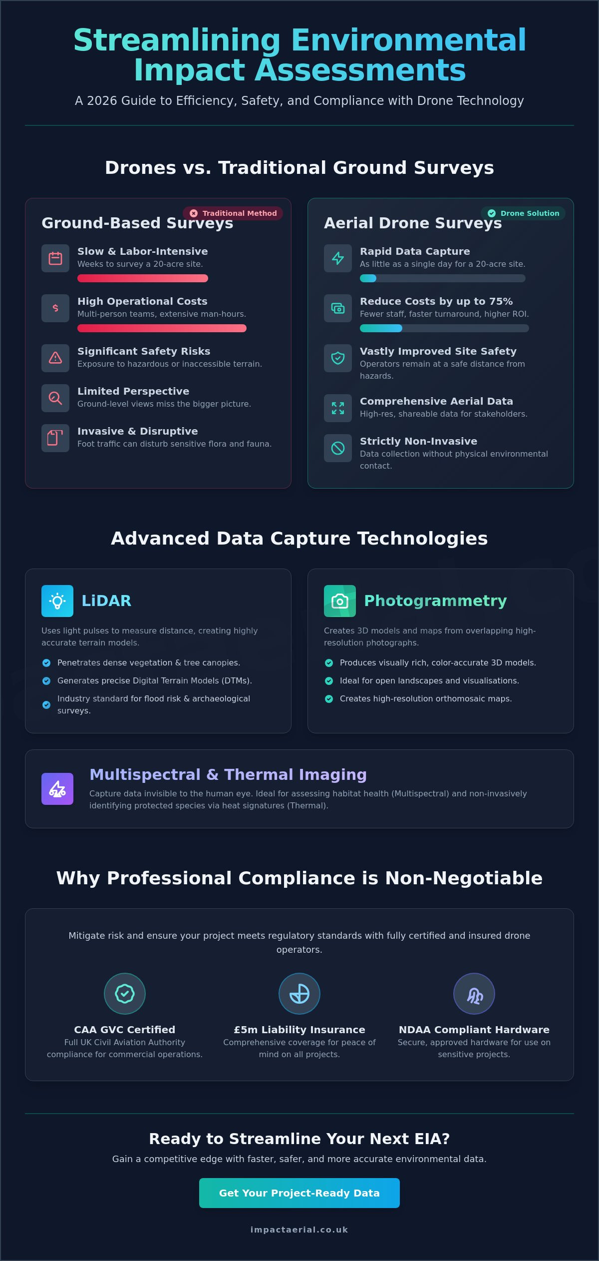
Drones vs. Traditional Ground Surveys: Efficiency, Safety, and Accuracy
Comparing a professional drone survey for environmental impact assessment to traditional ground-based methods reveals a significant gap in both operational efficiency and data depth. Manual surveys often require multi-person teams to spend weeks on-site, manually recording data points with total stations or handheld GPS units. This process is inherently slow and exposes staff to hazardous environments such as steep cliffs, tidal marshes, or unstable structures. Drones eliminate these risks by capturing the same data from the air, keeping personnel safely on stable ground while covering the same area in a fraction of the time.
Industry data suggests that drone surveys can be 50% to 75% less expensive than traditional ground-based surveys for the same project area. For example, a traditional topographic survey of a 20-acre site typically takes one to two weeks to complete. A drone can capture that same 20-acre site in a single day. This speed doesn’t just save money; it allows project managers to meet tight planning deadlines that would be impossible with manual methods. Automated flight paths also remove the risk of human error in manual mapping, ensuring that every centimetre of the site is documented with high-precision GPS positioning.
Repeatability is another critical advantage for long-term projects. Because drones use pre-programmed flight paths, they can return to the exact same coordinates months or years later. This ensures perfect data consistency for seasonal monitoring, allowing environmental consultants to track habitat changes or vegetation growth with absolute confidence. This level of temporal accuracy is nearly impossible to replicate with manual ground teams over multiple site visits.
Safety and Risk Mitigation on Site
Drones provide a safer alternative by removing the need for surveyors to work at height or enter deep, fast-moving water. This reduction in physical risk is a cornerstone of professional operations. A reputable operator will always carry £5m commercial liability insurance, which is the industry standard for high-stakes environmental projects. Beyond human safety, aerial surveys protect the environment itself. By removing foot traffic from sensitive areas, drones mitigate the risk of habitat trampling or the accidental spread of invasive species during the data collection process.
Data Accuracy and RTK Precision
Modern surveying drones often utilize Real-Time Kinematic (RTK) technology to achieve centimetre-level accuracy without the need for extensive ground control points. This precision is vital when defending EIA findings in court or during rigorous planning inquiries. While a traditional surveyor might collect hundreds of individual points, a LiDAR drone survey captures millions of points per flight. This incredible data density provides a much more detailed and reliable representation of the terrain, ensuring that no ecological constraint is overlooked.
Integrating Drone Data into Your Planning and Compliance Workflow
Successful integration of a drone survey for environmental impact assessment begins long before the aircraft leaves the ground. A pre-survey consultation is essential to align flight paths with specific ecological survey windows, ensuring data collection doesn’t interfere with protected species’ breeding seasons. This meticulous planning ensures that the resulting data satisfies the rigorous requirements of local planning authorities. In the UK, the synergy between CAA GVC certification and planning authority expectations is critical. Planners require data that is not only accurate but collected by an operator who understands the strict legal framework of commercial airspace.
The transition from raw data capture to a final EIA report involves a structured technical workflow. After the flight, raw imagery and sensor data undergo intensive processing to ensure they’re compatible with the software used by architects and planning officers, such as AutoCAD or ArcGIS. Collaborating with ecologists at this stage is vital. They use the high-resolution and multispectral imagery to classify habitats and identify ecological constraints with a level of detail that ground surveys can’t match. To ensure your datasets are refined for maximum impact, professional post-production services transform raw captures into project-ready evidence.
Seasonal Monitoring and Change Detection
Maintaining environmental compliance requires more than a single snapshot. Scheduling repeat surveys allows for automated change detection, which is essential for monitoring the spread of invasive species or tracking coastal erosion over time. Using ‘before and after’ overlays provides visual proof that environmental mitigation strategies are being followed during the construction phase. This temporal data is increasingly required to satisfy Biodiversity Net Gain (BNG) monitoring obligations, which often span several years.
Legal and Regulatory Evidence
Drone data creates a permanent, unalterable audit trail for every stage of a project. When presenting evidence to the Planning Inspectorate during appeals or inquiries, high-resolution aerial imagery provides a level of clarity that traditional reports lack. It’s a powerful tool for defending environmental strategies against public or regulatory scrutiny. Throughout this process, all data collection must strictly adhere to UK GDPR and privacy regulations. Professional operators ensure that any identifiable personal data is handled or redacted according to current legal standards, protecting both the client and the public.
Professional EIA Drone Services: Why Compliance and Certification Matter
Hiring a professional for a drone survey for environmental impact assessment is about more than just capturing high-resolution images. It’s a matter of regulatory compliance and rigorous risk management. In the UK, commercial drone operations are strictly governed by the Civil Aviation Authority (CAA). For complex EIA projects, hiring pilots who hold a General Visual Line of Sight Certificate (GVC) is essential. This certification proves the operator has passed rigorous theoretical and practical assessments, ensuring they can safely manage commercial flights in the challenging environments often found on development sites.
Safety is the primary concern for any project manager or ecological consultant. This is why £5m commercial liability insurance is the industry standard for professional drone surveys. It provides the necessary reassurance that all parties are protected against unforeseen events during the data collection process. Beyond the legalities, the choice of hardware directly impacts the quality of the final EIA report. We utilize high-end commercial platforms specifically engineered for the precision required in surveying. These systems provide the flight stability and sensor accuracy needed to deliver reliable data that planning officers and stakeholders can trust.
Regional knowledge is equally important for a successful survey. Having local expertise in Birmingham and the West Midlands allows an operator to navigate the specific geographical and regulatory nuances of the area. Local planning authorities often have specific expectations for data presentation. A partner who understands these regional requirements can significantly streamline the planning submission process and reduce the likelihood of data rejection.
The Impact Aerial Standard
Our approach centers on delivering high-tier quality through the use of commercial-grade drones equipped with 4K HDR cameras. This hardware ensures maximum clarity for habitat identification and detailed terrain mapping. Every project begins with a meticulous risk assessment and a commitment to safety-first operations that protect both people and sensitive environments. You can explore our broader drone survey capabilities to see how we apply these professional standards across various industrial sectors.
Choosing a Verified Partner
Vetting a drone provider requires looking beyond a simple portfolio of aerial photos. Professional affiliations and industry registers act as a non-verbal signature of quality and operational reliability. It’s important to understand the current UK drone license requirements for 2026 to ensure your chosen partner is fully compliant with the latest CAA rules. This due diligence protects your project from legal complications and ensures the data is admissible in formal planning inquiries.
If you’re ready to improve your site safety and data accuracy, contact us to request a tailored quote for your next environmental impact assessment project. We provide detailed consultations to ensure our flight paths and sensor choices align perfectly with your ecological requirements and planning deadlines.
Securing Your Project’s Future with Aerial Precision
Transitioning to a digital-first approach is no longer optional for complex planning submissions. By choosing a professional drone survey for environmental impact assessment, you gain access to centimetre-level data that traditional ground teams simply cannot match in the same timeframe. These surveys mitigate site risks while providing the high-resolution evidence required for Biodiversity Net Gain audits and long-term monitoring across the project lifecycle.
Success depends on working with a partner who prioritizes regulatory rigor as much as technical output. Our team utilizes advanced commercial-grade 4K HDR technology to deliver the clarity your stakeholders expect. With CAA GVC certified pilots and £5m commercial liability insurance, we ensure your data collection is both legally sound and operationally safe, providing psychological comfort and tangible business benefits.
Get a professional drone survey quote for your EIA project today and ensure your planning application is supported by the highest standard of aerial data. We look forward to helping you achieve your environmental goals with precision and reliability.
Frequently Asked Questions
What are the main benefits of using drones for an Environmental Impact Assessment?
Drones provide superior data density and safety compared to traditional ground methods. A drone survey for environmental impact assessment allows you to capture millions of data points across hazardous or inaccessible terrain without putting staff at risk. This non-invasive approach also ensures that sensitive habitats remain undisturbed during the data collection process.
Are drone surveys accurate enough for UK planning applications?
Yes, professional drone surveys meet the rigorous accuracy standards required by UK planning authorities. By using Real-Time Kinematic (RTK) technology, we achieve centimetre-level precision that is suitable for topographic mapping and ecological baseline reporting. This high-grade data provides a defensible evidence base for planning submissions and public inquiries.
How much does a drone survey for EIA cost in the UK?
The cost of an aerial survey depends on several factors, including the total acreage of the site and the specific sensors required, such as LiDAR or multispectral cameras. While drones generally offer significant savings over multi-week ground surveys, prices vary based on project complexity. It’s best to request a tailored quote to ensure the survey plan matches your specific EIA requirements.
Can drones perform surveys in bad weather or high winds?
Enterprise-grade drones are designed with specific IP ratings for moisture resistance and can operate safely in moderate winds. Most professional systems can fly in sustained winds of up to 22-27mph. However, for maximum data clarity and safety, we monitor weather windows closely to ensure flights take place during optimal conditions that won’t compromise the high-resolution output.
What data deliverables should I expect from an EIA drone survey?
Standard deliverables include high-resolution orthomosaic maps, 3D point clouds, and Digital Terrain Models (DTMs). These files are provided in formats compatible with common GIS and CAD software used by architects and environmental consultants. Depending on the project, you may also receive multispectral health maps or thermal signatures for protected species identification.
Is a special license required to fly drones for environmental monitoring?
Commercial drone operations in the UK require a GVC (General Visual Line of Sight Certificate) issued by the Civil Aviation Authority. This ensures the pilot is trained in complex flight planning and risk mitigation. Using a licensed and insured operator is a legal requirement for commercial work and provides the necessary audit trail for regulatory compliance.
How do drones identify specific plant or animal species?
Drones use a combination of 4K HDR visual imagery and multispectral sensors to identify ecological features. Multispectral cameras detect specific light wavelengths to assess vegetation health and habitat types. Thermal sensors are used to locate heat signatures from animals, such as bats or nesting birds, which might be obscured from view at ground level.
How long does it take to process drone data for an EIA report?
Initial data processing for standard 2D mapping typically takes between 48 and 72 hours following the site visit. More complex outputs, such as dense LiDAR point clouds or detailed 3D digital twins, may require additional time for post-production. This rapid turnaround allows environmental teams to begin their analysis much faster than traditional manual mapping allows.
 2 Norton Drive, Wythall, Birmingham, B47 6HH Company registration number: 11138586. VAT Number: 366 9068 55


