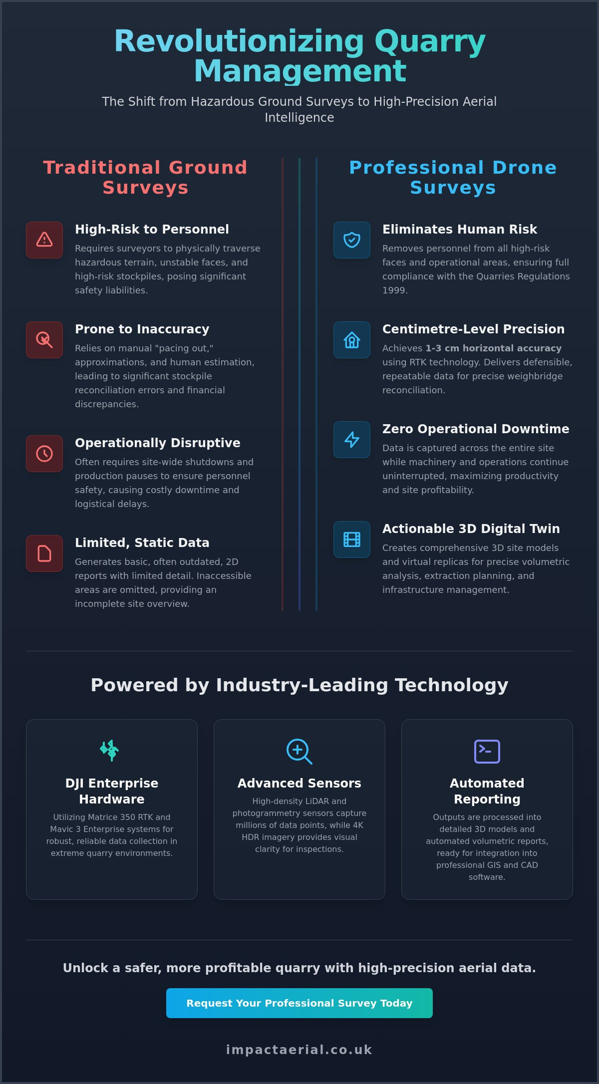
Drone Survey for Quarry Management: Optimising Safety and Volumetric Accuracy in 2026

What if the most hazardous and time-consuming task on your site could be completed with 1-3 cm horizontal accuracy without a single person setting foot on a high-risk face? For many site managers, the traditional approach to inventory and safety inspections is a slow process that often results in reconciliation errors. Relying on manual stockpile estimates isn’t just inefficient; it’s a liability. Integrating a professional drone survey for quarry management into your workflow changes this dynamic by delivering high-precision geospatial assets that bridge the gap between site safety and financial clarity.

We understand that maintaining operational continuity while meeting the strict demands of the Quarries Regulations 1999 is your top priority. You need data that is both defensible and actionable. This guide demonstrates how the latest 2026 aerial technology, from LiDAR-equipped Matrice systems to automated volumetric reporting, provides a safer and more cost-effective alternative to ground-based surveys. You’ll discover how to leverage precise 3D site models to eliminate downtime, satisfy stakeholders, and ensure your site remains at the forefront of industry compliance.

Key Takeaways

  • Learn how DJI Enterprise hardware and RTK technology provide centimetre-level geospatial accuracy for complex, high-output quarry environments.
  • Understand how a professional drone survey for quarry management ensures full compliance with the Quarries Regulations 1999 by removing personnel from high-risk faces.
  • Discover the workflow for achieving precise weighbridge reconciliation through automated volumetric analysis and detailed 3D site modelling.
  • Explore how high-resolution aerial filming and virtual tour creation streamline stakeholder reporting and support environmental reclamation initiatives.

The Evolution of Drone Surveys for Quarry Management

The modern drone survey for quarry management is a sophisticated, multi-layered data collection process. It has moved far beyond simple aerial snapshots. Today, professional operators use high-resolution sensors to capture millions of data points, creating a comprehensive digital record of the site. The Evolution of Drone Surveys has its roots in advanced remote sensing, allowing managers to analyze geological structures and material volumes with unprecedented detail. This shift from reactive photography to proactive geospatial mapping is fundamental for high-output UK quarries.

By moving to this data-centric approach, site managers can now support the “Digital Twin” concept. This involves creating a virtual replica of the physical quarry that evolves throughout its lifecycle. This model allows for precise planning of extraction phases, environmental monitoring, and infrastructure management. It’s an essential tool for long-term site viability and operational efficiency. The transition from basic photography to high-density LiDAR and photogrammetric mapping means we aren’t just looking at the site; we’re measuring it in three dimensions with surgical precision.

To better understand how precision is maintained on-site, watch this helpful video regarding ground control:

Overcoming Traditional Surveying Limitations

Traditional ground-based surveying is quickly becoming obsolete in modern industrial environments. Historically, surveyors had to physically traverse hazardous terrain, often requiring site-wide shutdowns or production pauses to ensure personnel safety. Drone technology eliminates these disruptions. We can now capture data across the entire site while machinery remains in operation. This approach also removes the human error associated with manual “pacing out” methods for stockpile estimation. Instead of relying on approximations, managers receive accurate, repeatable data from areas that were previously inaccessible, such as unstable faces or high-risk stockpiles.

Meeting Modern Industry Standards in 2026

In 2026, the standard for site documentation has reached a new level of technical sophistication. High-resolution 4K HDR imagery is now a baseline requirement for rigorous site documentation and compliance audits. These visuals provide the clarity needed for detailed face inspections and environmental monitoring. We align all aerial data with current UK geospatial standards for mining and excavation, ensuring that our outputs are ready for integration into professional GIS and CAD software. Essentially, we define drone quarry surveying as the integration of aerial photogrammetry with site-specific safety protocols. This technical synergy ensures that every flight contributes to both the safety and the profitability of the operation.

Technical Precision: DJI Enterprise Hardware and Data Collection

Achieving the highest levels of Technical Precision in a drone survey for quarry management requires more than just a standard aerial platform. It demands the DJI Enterprise ecosystem, specifically designed for industrial applications where environmental variables are extreme. By utilising platforms like the Matrice 350 RTK or the Mavic 3 Enterprise, we ensure centimetre-level geospatial accuracy through Real-Time Kinematic (RTK) technology. This system communicates directly with base stations or network corrections to eliminate the drift common in consumer-grade GPS. It’s this level of reliability that allows site managers to trust the resulting 3D models for critical financial and safety decisions.

Beyond positioning, the choice of sensor determines the quality of the geological data. High-resolution 4K HDR cameras, such as those found on the Zenmuse P1, capture fine-detail geological features and infrastructure wear that traditional methods might miss. These sensors provide the visual clarity needed to identify hairline fractures in rock faces or subtle erosion on haul roads. This level of detail is essential for maintaining a rigorous safety audit trail and supporting long-term site maintenance strategies.

Why Commercial-Grade Hardware Matters in Quarries

Quarries are notoriously difficult environments for flight. High winds, heavy dust, and magnetic interference from massive steel structures can compromise lesser equipment. DJI Enterprise models are built with IP-rated weather resistance and advanced redundancy systems, including dual vision and Time-of-Flight sensors on all six sides. This ensures the aircraft remains stable and safe even in the most exposed sites across the West Midlands and the wider UK. These platforms integrate seamlessly with professional surveying software, allowing for rapid data processing and a turnaround that keeps pace with high-output production schedules.

LiDAR vs. Photogrammetry for Topographical Mapping

Choosing the right sensor is as vital as the aircraft itself. We deploy LiDAR sensors, like the Zenmuse L3, when we need to penetrate thick vegetation on site boundaries or map areas obscured by heavy dust. LiDAR provides a high-density point cloud that can be “cleaned” to reveal the true ground level. Conversely, photogrammetry is the superior choice for high-detail 3D visual models and realistic textures. For the most complex sites, we often combine both methods to deliver a comprehensive drone survey that covers every technical requirement. Our team at Impact Aerial specializes in selecting the exact hardware configuration needed to meet your specific site objectives.

Drone Survey for Quarry Management: Optimising Safety and Volumetric Accuracy in 2026

Safety Compliance and Volumetric Accuracy

The technical precision established in the hardware phase directly translates into tangible financial and safety benefits. A drone survey for quarry management provides the objective, repeatable evidence required to satisfy both internal financial auditors and external health and safety inspectors. While traditional methods rely on manual measurements that introduce risk and uncertainty, aerial data offers a comprehensive view of the entire site without placing staff in harm’s way. Research published by the Society for Mining, Metallurgy & Exploration demonstrates how integrated aerial data supports Safety Compliance and Volumetric Accuracy through systematic site analysis and risk mitigation.

By keeping personnel away from high-risk quarry zones, operators can significantly reduce the potential for RIDDOR incidents. High-resolution data allows for the documentation of face stability and blast patterns over time, creating a historical record that helps predict and prevent potential failures. This proactive approach to safety is no longer an optional extra; it’s a core component of modern quarry operations. We use these visual assets to identify rock mass discontinuities and monitor the effectiveness of blast designs, ensuring that every phase of the extraction process is documented and reviewed.

Stockpile Management and Tonnage Reconciliation

Achieving weighbridge reconciliation is often the primary financial driver for aerial surveying. Our software calculates stockpile volumes by comparing the current high-density point cloud against a known “base” surface or previous survey data. This automated volumetric analysis provides end-of-month inventory figures that are far more accurate than manual “pacing” or visual estimates. By comparing this drone data with weighbridge records, site managers can create rigorous audit trails and monitor extraction rates against planned production targets. This level of detail allows for better forecasting and ensures that stock levels are always accurately reflected in financial reporting.

Aligning with Quarries Regulations 1999

The primary legislation governing health and safety in the UK is the Quarries Regulations 1999. Aerial surveys support these regulations by providing visual evidence for mandatory site safety health checks and geotechnical assessments. Our CAA GVC certified pilots are trained to operate within these strict industrial safety protocols, ensuring every flight is compliant and low-risk. Beyond pilot certification, commercial drone insurance is non-negotiable for professional quarry operators. We maintain comprehensive liability coverage specifically tailored for industrial environments, providing the reassurance and reliability that site managers require for long-term partnership.

Advanced Data Visualisation for Stakeholders

Raw geospatial data is invaluable for site engineers, but its inherent complexity can often alienate non-technical stakeholders. A high-quality drone survey for quarry management bridges this communication gap by transforming dense point clouds and technical orthomosaics into immersive, interactive visualisations. We move beyond simple spreadsheets to provide board members and investors with a clear, visual understanding of site progress. By annotating 3D models with specific hazard identifiers and operational notes, we create a living document that supports internal safety reporting and strategic planning. These assets ensure that everyone, regardless of their technical background, understands the current status of the site.

Cloud-based platforms now allow for seamless data sharing across multiple UK quarry sites. This enables a regional manager to review the volumetric accuracy of a site in one county while based in a central hub elsewhere. It’s a level of oversight that was previously impossible without significant travel time and expense. These models aren’t static; they are dynamic assets that allow for precise hazard identification and the documentation of site-specific safety protocols in real-time. This digital accessibility fosters a culture of transparency and accountability across the entire management structure.

Virtual Tours as a Remote Management Tool

Immersive 3D tours provide a unique perspective for remote management. Stakeholders can virtually “walk the site” from any location, inspecting specific faces or equipment without the need for high-vis gear or site inductions. We integrate our survey data with virtual tour creation to deliver board-level reporting that is both engaging and technically accurate. These tours also serve as a vital historical archive. By comparing tours over months or years, you can track reclamation progress and environmental changes with absolute clarity. This evidence is crucial for maintaining social license and proving compliance with planning conditions.

Post-Production and High-Resolution Reporting

The value of professional aerial filming drone footage extends far beyond simple site monitoring. High-resolution cinematic video is an essential tool for planning applications and community PR projects. It allows you to demonstrate your commitment to environmental reclamation and site safety in a way that technical reports cannot. We provide custom report formats designed for internal auditing and environmental compliance, ensuring that non-technical stakeholders receive clear, concise data visualisations. This level of post-production ensures that your data is not just accurate, but also persuasive and easy to digest for those making high-level financial decisions.

If you need to improve your stakeholder communication through high-end data visualisation, contact us to discuss our professional drone data visualisations.

Partnering with Impact Aerial for Quarry Success

Choosing a partner for a drone survey for quarry management requires more than just finding a pilot with a camera. It involves selecting a technical consultant who understands the unique complexities of high-output industrial environments. From our central Birmingham hub, Impact Aerial provides comprehensive aerial data services to quarry operators across the entire UK. We don’t just capture imagery; we deliver an end-to-end service that spans from the initial site survey to professional post-production and data delivery. This holistic approach ensures that the volumetric accuracy and safety data you receive is ready for immediate integration into your management workflows.

Our team consists of fully CAA GVC certified pilots who possess extensive experience in industrial and mineral extraction sites. We understand that trust is the foundation of any commercial partnership. That’s why we maintain £5m in commercial liability insurance, providing complete peace of mind for site managers and owners. This high level of coverage reflects our commitment to professional standards and our understanding of the scale of the operations we support. We aren’t an aggregator or a generalist agency; we’re specialists dedicated to providing the technical precision your business demands.

A Safety-First Approach with CAA GVC Certified Pilots

Every project begins with a rigorous risk assessment tailored specifically to your active site. We recognize that quarries are dynamic environments where safety protocols are paramount. Our pilots work closely with site managers to ensure our operations have zero impact on your production cycles. We don’t require site shutdowns or pauses in machinery movement. By continuously investing in the latest DJI Enterprise technology, we guarantee data reliability while maintaining the highest safety standards. This meticulous planning ensures that we remain compliant with all current aviation and site-specific regulations.

Getting Started with Your Quarry Survey Project

Your journey toward optimized site management starts with a detailed initial consultation. We’ll define your specific data requirements, whether you need centimetre-level volumetric calculations for tonnage reconciliation or high-resolution 3D models for stakeholder reporting. Our scheduling is designed to be flexible, allowing us to match your production cycles and wait for the ideal weather windows to ensure data consistency. This bespoke approach ensures you get the exact geospatial assets you need without unnecessary overhead. You can discuss your drone survey project with our technical team today to request a quote and see how we can transform your site data.

Advancing Your Site Operations with Aerial Precision

The transition toward digital site management is a present necessity for competitive quarry operators. By integrating a professional drone survey for quarry management, you replace manual guesswork with centimetre-level accuracy and robust safety evidence. We’ve explored how DJI Enterprise hardware and immersive data visualisations provide the clarity needed for weighbridge reconciliation and compliance with the Quarries Regulations 1999. These tools don’t just improve your data; they protect your workforce and your bottom line.

Impact Aerial brings technical expertise and a safety-first mindset to every industrial project. Our team of CAA GVC Certified Pilots and DJI Enterprise Hardware Specialists is ready to transform your site data while providing the security of £5m Commercial Liability Insurance. We handle the technical complexities so you can focus on high-output production and strategic growth.

Book your professional drone quarry survey with Impact Aerial and take the first step toward a safer, more accurate future for your site.

Frequently Asked Questions

How accurate are drone surveys for quarry stockpile volumes?

RTK-equipped drones achieve 1-3 cm horizontal accuracy, which translates to volumetric calculations that are typically within 1-2% of actual totals. This high level of precision provides a reliable audit trail for weighbridge reconciliation and financial reporting. By using dense point clouds instead of manual approximations, a drone survey for quarry management eliminates the significant margins of error found in traditional “pacing” methods.

Do drone surveys require the quarry to stop production during the flight?

No, professional drone surveys do not require site shutdowns or production pauses. Because the aircraft operates at a safe altitude, it remains entirely clear of active haulage routes and heavy machinery. We coordinate closely with site managers to integrate our flight plans into your existing production cycles. This ensures you receive high-quality geospatial data without any impact on your daily output or operational efficiency.

What UK regulations govern the use of drones in active quarries?

Operations are governed by Civil Aviation Authority (CAA) regulations and the Quarries Regulations 1999. Pilots must hold a valid GVC (General Visual Line of Sight Certificate) to operate commercially in these environments. Additionally, as of 2026, all aircraft must adhere to specific UK class-marking and Remote ID requirements. We ensure every flight is fully compliant with these legal standards and your specific site safety protocols.

How often should a quarry conduct a drone survey for effective management?

Most high-output sites conduct a drone survey for quarry management on a monthly or quarterly basis. Monthly surveys are ideal for accurate end-of-month inventory and tonnage reconciliation. However, for safety-critical monitoring or tracking extraction rates in rapidly changing sections, some operators prefer more frequent inspections. Regular data collection allows for better forecasting and maintains a continuous historical record for safety audits.

Can drones help with quarry environmental reclamation and planning?

Drones provide essential visual and topographical data for environmental reclamation and planning applications. High-resolution orthomosaics allow managers to track vegetation growth and terrain restoration progress with absolute clarity over several years. This data is invaluable for proving compliance with planning conditions to local authorities. Immersive 3D models also help stakeholders visualize future reclamation phases during the initial planning and consultation stages.

What is the difference between LiDAR and photogrammetry for quarry mapping?

LiDAR uses laser pulses to penetrate vegetation and dust, making it superior for mapping ground levels in overgrown or obscured areas. Photogrammetry uses high-resolution overlapping images to create detailed 3D visual models and textures. While LiDAR is excellent for terrain modelling, photogrammetry is often the preferred choice for visual inspections and creating immersive virtual tours for stakeholder reporting and community PR.

Do I need special insurance to have a drone fly over my quarry site?

The drone operator must provide specialist commercial insurance that covers aerial operations. Standard business or public liability insurance rarely includes aviation risks. We maintain £5m in commercial liability insurance specifically tailored for industrial environments. This ensures that the quarry operator is fully protected against any aviation-related risks, providing the reassurance and reliability required for professional site management.

How long does it take to receive the processed survey data and reports?

Processed survey data and volumetric reports are typically delivered within 24 to 72 hours of the flight. While the raw data is captured in just a few hours, professional post-production and rigorous volumetric analysis require specialized software processing. This rapid turnaround ensures that site managers can use the data for immediate operational decisions, financial reconciliation, and internal safety reporting without delay.

Measuring Stockpile Volumes with a Drone: The Ultimate Guide to Precision Volumetrics

Could an invisible 15% error margin in your bulk inventory be quietly draining your company’s annual profits? For a UK quarry or construction site managing £1 million in aggregate, traditional manual estimation often results in a £150,000 discrepancy that complicates financial reporting. Measuring stockpile volumes with a drone eliminates this uncertainty by replacing inconsistent ground-based measurements with high-precision, survey-grade aerial data.

You already know that asking staff to climb unstable stockpiles with GPS rovers is a significant safety liability that slows down your entire operation. It’s a frustrating trade-off between site safety and data frequency that many site managers struggle to balance. This guide will teach you how to leverage professional drone technology to turn stockpile auditing into a precise, digital-first financial asset. We’ll examine the specific photogrammetry workflows, CAA-compliant safety protocols, and data processing techniques that deliver millimetre-level accuracy and provide total peace of mind for your next inventory audit.

Key Takeaways

  • Discover how transitioning from manual “walking the pile” methods to aerial photogrammetry turns rough estimates into precise, digital-first financial assets.
  • Understand the technical differences between LiDAR and photogrammetry and how point cloud data provides the foundation for millimetre-accurate calculations.
  • Master a professional five-step workflow for measuring stockpile volumes with a drone, ensuring repeatable accuracy through automated data capture and meticulous planning.
  • Ensure your site operations remain fully compliant with UK Civil Aviation Authority (CAA) regulations, including the essential GVC and A2 CofC certifications for added peace of mind.
  • Learn how to integrate high-quality volumetric data into Building Information Modelling (BIM) and use change detection to monitor site progress over time.

The Evolution of Volumetric Analysis: Why Drones are Replacing Manual Methods

Measuring stockpile volumes with a drone has transformed from a niche technological experiment into a core requirement for UK construction, mining, and aggregate sectors. This methodology relies on drone photogrammetry, a sophisticated science where specialized software triangulates thousands of points from aerial images to create a high-density 3D model. Unlike legacy methods that rely on sparse data, this digital approach captures every contour and depression of a pile with millimetre-level detail.

To better understand this concept, watch this helpful video:

For decades, site managers relied on “walking the pile” with a GPS rover or, in some cases, visual estimations. These manual techniques are increasingly viewed as operational liabilities. The shift toward aerial data collection is driven by the need for financial transparency and a rigorous commitment to site safety.

The Limitations of Traditional Surveying

Traditional surveying methods carry a significant margin of error, often ranging between 10% and 25% depending on the complexity of the pile. When a surveyor walks a stockpile, they only capture a few dozen data points. The software then interpolates, or guesses, the volume between those points, which leads to massive discrepancies on uneven surfaces.

Health and safety is another primary concern. The Health and Safety Executive (HSE) consistently identifies falls and unstable ground as major risks in industrial environments. Sending staff to climb 15-metre tall piles of loose aggregate is a high-risk activity that is difficult to justify when safer alternatives exist. Additionally, manual surveys are slow; a large site can take days to map, creating a significant time lag between data collection and the final report.

Primary Benefits of Drone-Based Measurements

Transitioning to drone-led volumetrics provides immediate, tangible improvements to site management:

  • Unmatched Speed: A CAA GVC certified pilot can capture data for an entire 50-acre quarry in under 30 minutes, a task that would take a ground crew several days.
  • Extreme Accuracy: While a manual survey captures dozens of points, measuring stockpile volumes with a drone involves millions of data points. This reduces the margin of error to below 2%, providing a “digital twin” of the inventory.
  • Cost-Effectiveness: Drones operate without requiring site downtime. Heavy machinery can continue to move while the drone stays safely overhead, eliminating the expensive productivity losses associated with ground-based surveys.

The Science of Precision: How Drone Photogrammetry and LiDAR Calculate Volume

Accurate volume calculation relies on two distinct methods: Photogrammetry and Light Detection and Ranging (LiDAR). Both technologies serve the same goal of creating a “Point Cloud.” This is a dense collection of millions of individual data points, each assigned specific X, Y, and Z coordinates. By stitching these points together, software generates a high-resolution 3D digital twin of your site. When measuring stockpile volumes with a drone, the software identifies the “base” of the pile, which is the floor or surface the material sits on. It then calculates the exact cubic area between this digital base and the top surface of the point cloud.

To achieve this, drone pilots must manage two critical variables: image overlap and Ground Sampling Distance (GSD). We typically maintain an 80% frontal and 70% side overlap to ensure the software can triangulate every feature from multiple angles. GSD represents the actual distance on the ground between the centres of two consecutive pixels. A GSD of 1cm means each pixel in the map represents one square centimetre. Lower GSD numbers mean higher resolution and more reliable data for your inventory reports.

Photogrammetry vs. LiDAR: Which is Right for Your Site?

Photogrammetry uses high-resolution 2D images to reconstruct 3D models through complex mathematical triangulation. It’s an excellent, cost-effective choice for light-coloured materials like sand, gravel, or crushed concrete. However, it struggles with “featureless” surfaces or dark materials that absorb light. LiDAR uses active laser pulses to measure distances. It’s superior for measuring coal, which is notoriously difficult for standard cameras to resolve. The Science of Drone-Assisted Volumetrics demonstrates that LiDAR also penetrates gaps in vegetation, making it the preferred choice for overgrown sites or stockpiles stored under partial tree cover.

The Role of RTK and Ground Control Points (GCPs)

Precision depends on how well the drone knows its own position in space. We use RTK (Real-Time Kinematic) technology, which provides centimetre-level positioning by communicating with a base station or satellite network during flight. While RTK handles relative accuracy, we use Ground Control Points (GCPs) for absolute geographical accuracy. These are physical markers placed on the ground with known coordinates. They anchor the entire 3D model to the real world, ensuring your 2024 data aligns perfectly with surveys from previous years. Impact Aerial utilises specialised survey drones to capture this data, providing the meticulous detail required for commercial audits and financial reporting. If you’re unsure which technology fits your specific material type, our team can provide a technical consultation to ensure you get the most accurate results for your next survey.

A 5-Step Workflow for Measuring Stockpile Volumes with a Drone

Achieving sub-5cm accuracy when measuring stockpile volumes with a drone requires a repeatable, professional workflow. It’s not simply a matter of taking photos from the air; it’s about data integrity and technical precision. We follow a strict five-step protocol to ensure every cubic metre is accounted for and every report is audit-ready.

Pre-flight Planning and Site Assessment

Before any rotors spin, our team conducts a thorough site assessment. This involves checking UK airspace through NATS or Drone Assist to identify temporary flight restrictions or nearby aerodromes. We verify weather forecasts, ensuring wind speeds remain below 20mph for stable imagery. Flight altitude is calculated based on the required Ground Sampling Distance (GSD) for the project. For most UK construction and quarry sites, we aim for a GSD of 1cm to 2cm per pixel. We also identify physical hazards like tower cranes, high-voltage lines, or conveyor systems to ensure a safe flight path.

Data Capture and Overlap Strategies

We use automated flight software to maintain consistent image overlap. A minimum of 80% frontal and 75% side overlap is non-negotiable for high-quality photogrammetry. While nadir (top-down) shots are sufficient for flat material, oblique imagery is essential for complex, steep-sided piles or overhangs. GSD is the distance between pixel centres on the ground. Lower GSD values provide higher resolution, which is vital for calculating small granular changes in material. Our pilots monitor the live feed to ensure every angle of the stockpile is captured without gaps.

Data Processing and 3D Modelling

Once the flight is complete, we process the raw imagery using industry-leading software like DJI Terra or Pix4D. These platforms stitch thousands of 2D images into a dense 3D point cloud and a Digital Surface Model (DSM). A critical part of this stage is removing “noise” from the data. We manually “clean” the model by removing plant machinery, vehicles, or stray vegetation that would otherwise inflate the volume calculations. We then validate the digital model against known ground control points or checkpoints to guarantee the results meet professional survey standards.

Analysis and Reporting

The final stage involves calculating volumes, slopes, and material densities based on the cleaned 3D model. We define the base plane for each pile to ensure the calculation only includes the material above the ground level. We then export this data into formats your site managers can use immediately. Common deliverables include:

  • .CSV files: For direct import into inventory spreadsheets.
  • .DXF or .DWG files: For integration with AutoCAD and engineering software.
  • .OBJ or .PLY files: For detailed 3D visualisations and digital twins.
  • PDF Summary Reports: Providing a clear overview of total volumes and site conditions.

This structured approach ensures your site remains compliant and your inventory records remain 99% accurate, providing the peace of mind that comes with professional data gathering.

Operational Safety and UK Compliance in Drone Surveying

Commercial drone operations in the United Kingdom are governed by strict legal frameworks enforced by the Civil Aviation Authority (CAA). For industrial clients, compliance isn’t just a legal checkbox; it’s a critical component of site risk management. When measuring stockpile volumes with a drone, the primary advantage is the immediate improvement in personnel safety. Traditional surveying often requires staff to climb unstable material piles or navigate “red zones” where heavy plant machinery and 40-tonne dump trucks operate. Drones eliminate this risk by capturing high-precision data from the air, keeping your team safely away from active hazards.

Operating a drone for commercial gain without the correct permissions is illegal and can void your site insurance. Impact Aerial maintains a meticulous approach to compliance, ensuring every flight meets the latest UK standards. This professional rigour provides the reliability needed for high-stakes industrial environments like quarries, ports, and construction sites.

CAA GVC Certification and Why It Matters

The regulatory landscape changed significantly on 31 December 2020, moving away from the old PfCO system. All Impact Aerial pilots hold a professional drone license known as the General Visual Line of Sight Certificate (GVC). This qualification is essential for complex commercial work. It demonstrates that the pilot has undergone rigorous theoretical and practical examinations. Hiring an uncertified operator exposes your business to massive legal liabilities and potential fines from the CAA. Our GVC status allows us to operate in more demanding environments where precision and safety are paramount.

Managing Site Risks and Public Safety

Every project begins with a comprehensive pre-site survey and a bespoke Risk Assessment and Method Statement (RAMS). We don’t just show up and fly; we evaluate airspace restrictions, ground hazards, and local weather patterns to ensure a safe mission. For added peace of mind, we carry £5m commercial liability insurance specifically tailored for drone operations. This level of cover is often a mandatory requirement for Tier 1 contractors and major industrial firms. While we operate in controlled industrial settings, we still adhere to the fundamental principles of the UK Drone Code to protect public safety and maintain the highest professional standards.

  • Removing Foot Traffic: Surveyors no longer need to walk on stockpiles, reducing the risk of falls or engulfment.
  • Data Precision: Using drones for measuring stockpile volumes with a drone provides millions of data points without interrupting site production.
  • Legal Security: Full CAA compliance ensures your data is gathered legally and is admissible for audits or financial reporting.

Our commitment to safety and regulation ensures that your data collection is seamless and risk-free. If you need a compliant, professional partner for your next survey, contact Impact Aerial today.

Transforming Data into Actionable Insights for Construction and Mining

Measuring stockpile volumes with a drone offers more than just a snapshot of current inventory. It provides a high-fidelity data stream that integrates directly into the modern project lifecycle. For UK construction firms and quarry operators, this precision translates into better resource allocation and reduced operational risk. The ability to capture millions of data points in a single flight turns a hazardous manual task into a streamlined digital process.

Integrating Drone Data into BIM and ERP Systems

The transition from raw aerial imagery to actionable BIM (Building Information Modelling) data is seamless when using professional workflows. We export data in industry-standard formats such as .LAS, .DXF, .OBJ, and .XYZ. This ensures full compatibility with Revit, AutoCAD, and Civil 3D. Site managers can overlay 3D stockpile models onto original design plans to identify discrepancies immediately, ensuring the project stays within its original scope.

Creating a Digital Twin of your site allows for ongoing monitoring without pausing operations. These models are used to simulate site logistics, plan haul roads, or assess drainage patterns. It’s a meticulous approach that ensures your digital records match the physical reality of the site at every stage. This level of detail is essential for complex projects where space is limited and material placement is critical for safety and efficiency.

Real-Time Inventory Management and ROI

The financial benefits of measuring stockpile volumes with a drone are quantifiable and immediate. Traditional ground surveys often carry a margin of error between 5% and 10%, which can lead to significant inventory write-offs. In recent 2023 industry benchmarks, precise aerial volumetrics helped firms reduce these discrepancies to under 2%. For a site holding £1,000,000 in raw materials, that’s a potential £30,000 saving by avoiding tax errors and stock adjustments.

Change detection is a vital tool for site audits. By comparing surveys from two different dates, you can visualize exactly where and how much material has been moved. This provides a timestamped, visual record that satisfies both internal stakeholders and external auditors. Partnering with professional drone services ensures these surveys meet CAA GVC standards, providing peace of mind alongside technical accuracy. For those needing a broader site analysis, our comprehensive drone survey guide explains how these data-gathering techniques apply to larger infrastructure and commercial property projects across the West Midlands and beyond.

Optimise Your Site Intelligence with High-Precision Data

Moving away from traditional ground-based surveys to measuring stockpile volumes with a drone reduces data collection time by up to 80% while significantly improving worker safety. By integrating DJI Enterprise grade hardware with sophisticated LiDAR or photogrammetry workflows, your business gains access to volumetric data that is both repeatable and highly accurate. These digital insights allow for more precise financial forecasting and tighter inventory control across construction and mining projects throughout the UK.

Impact Aerial provides the technical expertise required to navigate complex airspace regulations with ease. Our CAA GVC Certified pilots maintain £5m commercial liability insurance, ensuring every survey meets the highest standards of safety and professionalism. We don’t just capture images; we deliver the meticulous data needed for added peace of mind in a competitive market. It’s time to replace guesswork with engineering-grade precision that protects your bottom line.

Contact Impact Aerial for a Precision Volumetric Quote to see how our professional drone services can transform your operational workflow.

Frequently Asked Questions

How accurate are drone stockpile measurements?

Drone surveys achieve volumetric accuracy between 1% and 3% when compared to traditional ground-based surveying methods. By using High Dynamic Range (HDR) sensors and Ground Control Points (GCPs), we maintain vertical accuracy within 20mm to 50mm. This precision is vital for measuring stockpile volumes with a drone in construction and mining sectors. Our CAA GVC certified pilots follow strict data-gathering protocols to ensure every calculation meets RICS standards.

Do I need to stop site operations during a drone survey?

You don’t need to halt site operations while we conduct the aerial survey. Our enterprise drones operate at a safe altitude, allowing plant machinery and personnel to continue working without any interruption. This provides a massive efficiency gain over ground-based surveys where staff must walk near heavy equipment. For added peace of mind, we conduct full site risk assessments to ensure our flight path remains clear of active zones.

What file formats will I receive after the survey?

We provide data in industry-standard formats including .DXF, .DWG, and .CSV for seamless integration with CAD and BIM software. You’ll also receive high-resolution orthomosaic maps in .TIFF or .JPG formats and 3D point clouds in .LAS or .OBJ files. These outputs integrate directly into platforms like AutoCAD or Revit. This ensures your site managers can immediately use the precise data for inventory reporting and financial audits.

Is a drone survey cheaper than traditional methods?

Drone surveys are typically 40% to 60% more cost-effective than traditional ground-based topographic surveys. The primary savings come from reduced man-hours, as a drone can capture a 10-hectare site in under 30 minutes. You also eliminate the need for expensive safety equipment or site shutdowns. While we don’t provide fixed pricing without a site assessment, the ROI is evident through faster data turnaround and increased worker safety.

How long does it take to get the volume results?

You can expect to receive your finalised volume reports within 24 to 48 hours after the flight is completed. Processing thousands of high-quality images through photogrammetry software takes several hours of computational time. Once the data-gathering phase is complete, our technical team verifies the point cloud before generating the final volumetric calculations. This rapid delivery allows for real-time inventory management that traditional methods simply cannot match.

Can drones measure stockpiles inside warehouses or sheds?

Yes, we use specialised Elios drones or LiDAR-equipped units to measure stockpiles within indoor facilities and sheds. These drones feature protective cages and collision-avoidance technology to navigate confined spaces where GPS signals are unavailable. This capability is essential for managing bulk materials like grain or salt stored in dark environments. Measuring stockpile volumes with a drone indoors provides a safer alternative to manual measurements in dusty or hazardous areas.

What weather conditions prevent a drone stockpile survey?

We cannot fly in sustained winds exceeding 22mph or during periods of heavy rain and snow. Our DJI Enterprise fleet is IP-rated, but moisture on the lens degrades the photogrammetry quality required for precise volumes. Low cloud cover or fog also prevents the drone from maintaining the necessary visibility for safe operation. We monitor Met Office forecasts closely to schedule flights during optimal windows, ensuring the highest data integrity for your project.

Do I need a special license to fly a drone on my own site?

You need a GVC (General Visual Line of Sight Certificate) from the CAA if you intend to fly drones over 250g for commercial purposes in the UK. Operating without this certification or valid commercial liability insurance can lead to legal penalties and voided site insurance. Most site owners prefer to hire our certified professionals to handle the regulatory compliance and safety risk assessments. This ensures all data-gathering follows current UK drone legislation and provides total peace of mind.