
Drone Photogrammetry Services UK for Construction Projects

Drone photogrammetry services in the UK are only as dependable as the planning behind the data capture. For a construction team, that means defining the information needed and planning a safe flight suited to the site.

Look beyond the images: ask who will fly, what insurance is in place and how the work will be coordinated around an active site. Survey outputs can help teams document conditions, monitor change and compare progress with drawings, but the capture plan must suit the project.

This guide explains what construction drone surveys can deliver, how pilots approach CAA authorisation and insurance, and how privacy and site safety are considered. It also introduces common outputs, including orthomosaics and 3D models, and the factors that shape a survey brief, so you can understand what to expect before planning aerial monitoring for your project.

Key Takeaways

  • Match the survey plan to the construction task, whether you need progress records, measurements or comparisons with drawings.
  • Choose the right output for the work: orthomosaics, point clouds, 3D meshes and surface models serve different project needs.
  • Plan image capture with residents and neighbouring properties in mind, and consider how the site layout affects data collection.
  • Before a flight, understand how the pilot handles CAA authorisation, insurance and safety around an active construction site.

Drone surveying for construction and house building

Construction teams use aerial surveys to record site conditions and monitor changes as work progresses. Photogrammetry can support measurements, earthwork calculations and comparisons with project drawings.

Survey Deliverables and Turnaround

Deliverables depend on the survey brief and may include precision imagery, site recordings, orthomosaics or 3D models. For example, teams can compare repeat surveys to quantify earth moved, or inspect roof and façade imagery for visible condition changes.

The work includes planning, on-site capture, processing and preparing the agreed outputs. Clarify the delivery schedule and whether you need a single site record or repeat monitoring at construction milestones.

CAD Drawings and Survey-Ready Data

Survey data can be compared with CAD or PDF drawings to review site conditions against the design. Before capture, identify the drawing revision, survey area and comparison required. This helps ensure the resulting data supports a defined project task.

For house building, teams can compare completed work with architects’ drawings and flag discrepancies for review. Agree which data and drawing references to use, then make sure the final deliverables suit the project team’s review process.

Weather Considerations for Drone Surveys

Weather affects when a flight can take place and the quality of the imagery. Wind can affect flight stability, while rain or poor visibility can make safe capture and clear site records more difficult.

Build flexibility into the site programme, especially when earthworks or access conditions are changing. Review the forecast and site conditions before capture, and plan for a suitable flight window rather than relying on a fixed date regardless of conditions.

Project Cost and Turnaround Factors

Project cost and turnaround depend on the survey area, site complexity, access, required outputs and processing scope. A single progress record differs from repeat monitoring or a survey that needs CAD comparisons, roof imagery and façade coverage.

To plan the work, define the site boundary, purpose, deliverables and required delivery date in the brief. Those details help set the capture and processing scope; weather and site readiness can also affect scheduling and completion time.

Orthomosaics, point clouds, 3D meshes and surface models

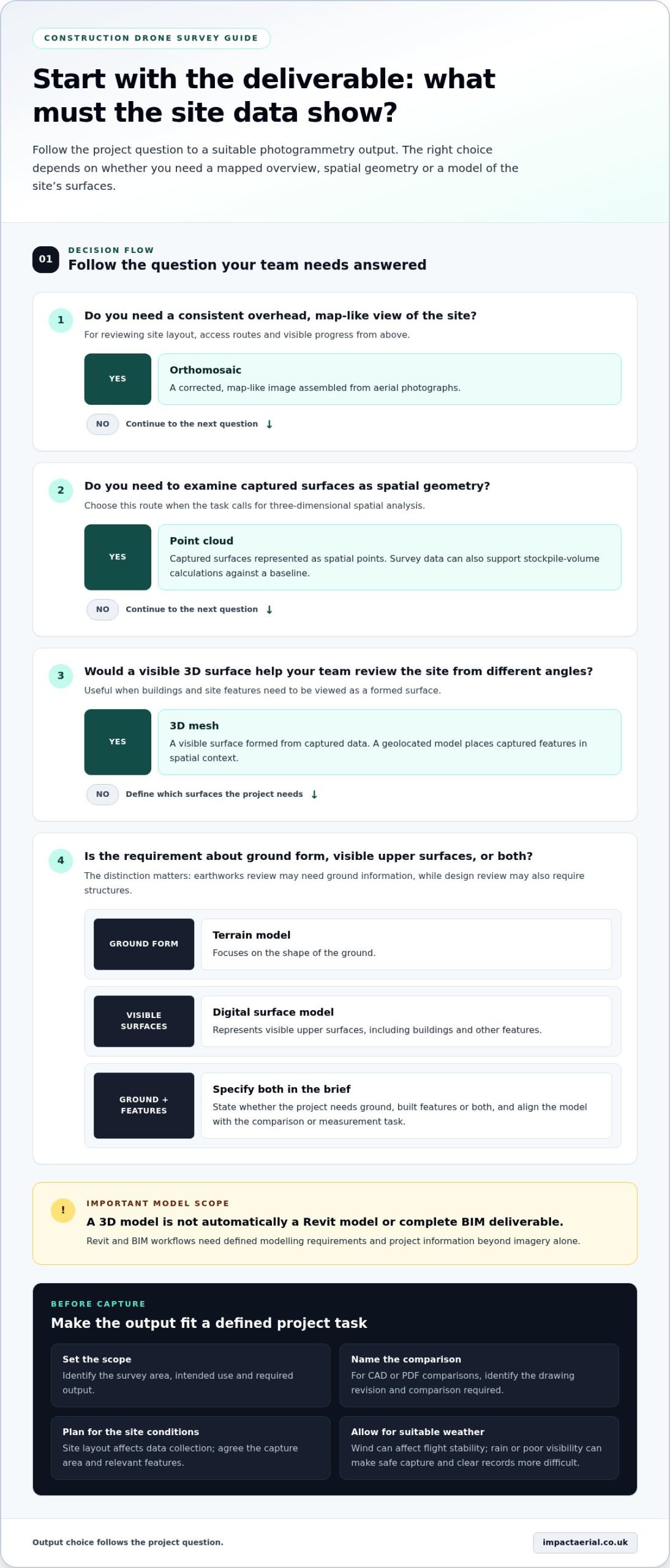
UK drone photogrammetry can produce orthomosaics, point clouds, 3D meshes and surface models. The right output depends on whether the project needs a mapped overview, measurable geometry or a digital representation.

Orthomosaics and Point Clouds

An orthomosaic combines aerial images into a corrected, map-like view of a site. Construction teams can use it to review the layout, access routes and visible progress from a consistent overhead perspective. A point cloud represents captured surfaces as spatial points, helping teams examine geometry in three dimensions.

Choose the output to match the task: an orthomosaic suits visual site review, while a point cloud supports spatial analysis. Drone survey data can also be used to calculate stockpile volume against a baseline, helping teams track material quantities between surveys.

3D Meshes and Geolocated Models

A 3D mesh forms a visible surface from captured data, making buildings and site features easier to view from different angles. Geolocated models place captured features in a spatial context, which helps project teams compare locations and communicate findings. Specify the area and intended use before capture so the model addresses a defined project need.

For example, a modular housing development model was created using more than 2,500 drone images. A model can support visual review, but it does not automatically constitute a Revit model or a complete BIM deliverable. Revit and BIM workflows need defined modelling requirements and project information beyond imagery alone. For property review, survey outputs for commercial properties can help teams assess what visual data will serve their project.

Surface and Terrain Models

A digital surface model represents visible upper surfaces captured across an area, including buildings and other features. A terrain model focuses on ground form. This distinction matters: a house-building team reviewing earthworks needs ground information, while a design review may also require structures to be represented.

Topographical survey information can be converted from 2D into 3D and displayed as a 3D surface. Define whether the project needs ground, built features or both, then align the requested model with the comparison or measurement task. That gives the survey team a clear basis for preparing useful digital data.
Drone Photogrammetry Services UK for Construction Projects

Will the drone photograph residents or neighbouring properties?

Photogrammetry records images across a planned survey area, so the flight plan should define the construction boundary and relevant features. Accuracy depends on image quality, coverage, processing and project control data. LiDAR and traditional surveying use different measurement methods, so no method is universally more accurate.

For a construction site beside homes, agree the capture area before the flight. Plan the route and camera direction around the required land, buildings or access areas, rather than collecting broad imagery without a project purpose. This keeps capture focused while recording the features needed for the work.

Photogrammetry uses overlapping photographs to create measurable outputs, such as a surface model. Clear, consistent imagery helps represent visible surfaces, while obscured ground, repetitive textures or moving objects can affect the results. Open ground with visible earthworks presents different capture conditions from a crowded plot with trees and active plant.

LiDAR collects distance measurements using laser returns and can be useful for land topography and terrain information. It can support cut-and-fill calculations alongside photogrammetry; the right approach depends on site cover, required detail and intended analysis. For example, a team assessing earth moved can compare repeat survey data with a baseline.

To account for residents and neighbouring properties, mark the work boundary and sensitive viewpoints in the survey brief. The operator can plan the flight path and camera framing around the required site features, then review the captured material against the agreed deliverable. For a roof survey near adjacent homes, the plan can prioritise the target roof and avoid unnecessary views beyond it.

Traditional surveying remains useful when a project needs specific ground measurements or established control points. Drone imagery offers broader visual coverage, while LiDAR provides another route to spatial data. Define the accuracy requirement, area, surface conditions and intended use first. These criteria help determine the collection method and data checks that fit the survey.

CAA authorisation, insurance and site safety

Commissioning a survey starts with the site, purpose and required outputs. The operator then plans the flight, reviews airspace and access, assesses site risks and agrees the capture arrangements before attending.

Ask about pilot qualifications and how the planned operation will be assessed. Impact Aerial’s pilots are CAA-GVC Certified, and the company holds full UK CAA Operational Authorisation. Authorisation and operational planning need to be considered for the specific location and task, rather than treated as generic permission for every flight.

Insurance is another practical part of commissioning. Construction teams should establish how survey activity fits the site’s access arrangements, working zones and contractor coordination. For example, a flight over an active build needs a clear plan for people, plant and the drone’s operating area.

Key operational considerations include changing weather, nearby airspace constraints, privacy and activity on the ground. Wind or poor visibility can affect capture conditions; site teams can help by identifying moving plant, restricted areas and schedule changes. A neighbouring property or occupied building calls for a focused capture plan that limits imagery to what the survey requires.

Before commissioning, provide the site location, boundary, purpose, preferred date and required deliverables. Identify access points, active work areas, nearby residents and known airspace concerns. The operator can use these details to plan the flight and explain the authorisation and safety arrangements for that operation. Insurance documents and pilot credentials can also be discussed as part of the project.

Keep the decision practical: establish who coordinates site access, how workers are informed, and what happens if conditions change. These steps connect the flight plan to real construction activity, rather than treating aerial capture as separate from site management. Discuss a construction drone survey with the team before setting the site programme.

Impact Aerial: Aerial Filming and Photography

Impact Aerial provides aerial filming and photography for construction teams that need clear visual records of a site. Construction Site Monitoring helps teams review changing conditions and communicate updates. Drone Commercial Property Surveys are suited to visual inspections of commercial buildings, while PV Solar Farm Thermal Surveys address a different specialist inspection need.

Choose the service to match the project outcome: scheduled site visuals, building imagery or thermal survey information. A clear brief covering the site, intended use and required output helps shape the work. Impact Aerial’s aerial services are a practical option when a construction team needs professionally captured views for monitoring, review or communication.

To discuss aerial filming and photography for your project, contact Impact Aerial or visit impactaerial.co.uk.

Plan your next project with confidence

Turn your survey requirement into a practical project brief by identifying the decision the data needs to support. For example, specify whether you need to document construction progress, assess a commercial property or inspect a solar farm. This helps define the scope for drone photogrammetry services in the UK and keeps the project focused on useful outcomes.

Impact Aerial offers Aerial Filming and Photography, Drone Commercial Property Surveys and PV Solar Farm Thermal Surveys. Consider which service matches your site and intended use, then share the project context, access considerations and preferred deliverables. A clear brief gives the discussion a useful starting point without assuming every site needs the same approach.

Contact Impact Aerial about your site to discuss the right aerial service for your project. A considered first step can help you move forward with clarity.

Frequently Asked Questions

Are your pilots licensed and insured?

Yes. For a construction project, include the site location and intended flight in the planning discussion. Pilot credentials sit alongside operational planning, helping site managers coordinate drone activity with access arrangements and existing site controls.

Do you cover the whole UK?

Impact Aerial is based in Birmingham and the West Midlands and provides services across the UK. For a project elsewhere, include the site location, access arrangements and preferred survey dates in your initial brief. These details help shape travel and capture planning, while construction activity and local surroundings inform how the survey is organised.

What happens if the weather is bad?

Wind, rain or poor visibility can make a planned flight unsuitable for safe operation or clear image capture. Build flexibility into the site programme and coordinate a suitable alternative capture window with the project team. Keep access details and deliverable priorities to hand so a weather-related schedule change can be managed alongside site activity.

Which UK companies provide drone photogrammetry services, and where do they operate?

Impact Aerial provides drone services across the UK from its base in Birmingham and the West Midlands. Relevant services include Construction Site Monitoring, Drone Commercial Property Surveys and Aerial Filming and Photography. The right service depends on whether the project needs recurring progress visuals, commercial property imagery or another defined aerial outcome. Include the site location and intended use in your enquiry.

What deliverables do UK drone photogrammetry services provide, such as orthomosaics, 3D models and point clouds?

A survey brief can specify an orthomosaic for mapped site viewing, a point cloud for spatial analysis, or a 3D mesh or model for visualising form. Surface models can support terrain or built-feature review, and data can be compared with drawings or earlier captures. Impact Aerial’s stated capabilities include 3D imaging and detailed topological graphics; the requested format should suit the project’s intended use.

What UK CAA rules and permissions apply to commercial drone photogrammetry?

CAA requirements and authorisation should be considered for the planned operation and site, rather than inferred from commercial purpose alone. Impact Aerial’s pilots are CAA-GVC Certified, and the company holds full UK CAA Operational Authorisation. Site location, surrounding airspace, people and ground activity are practical planning considerations. Include the precise site and survey task in your project brief.

Aerial Photography for Landscape Design: 2026 Guide

High-resolution drone imagery isn’t merely a visual asset to impress prospective clients; it is an indispensable technical foundation for modern site planning. Integrating aerial photography for landscape design allows practices to capture precise spatial context, uncover subtle grade changes, and eliminate the manual measurement errors that routinely stall early master planning.

Every landscape architect knows the frustration of conventional site walkovers, where hidden drainage paths go unnoticed and static CAD drawings fail to convey real-world scale during critical pitches. In this 2026 guide, you’ll discover how high-resolution aerial photography transforms landscape design workflows from initial topographical site assessment through to client presentations. We detail how to integrate georeferenced orthomosaic data directly into your CAD environment, communicate complex concepts with clarity, and ensure rigorous UK CAA regulatory compliance across every flight operation.

Key Takeaways

  • Discover how integrating commercial aerial photography for landscape design accelerates baseline site assessments, replacing tedious ground walkovers with comprehensive spatial data.
  • Identify hidden site drainage issues, microclimates, and canopy shadow patterns early to inform resilient planting plans and master designs.
  • Learn the exact workflow required to export georeferenced orthomosaics, digital elevation models, and textured 3D meshes directly into standard CAD and BIM software.
  • Evaluate the measurable operational efficiencies of continuous photogrammetry compared to traditional manual spot-height surveys.
  • Understand essential UK CAA legal requirements, including GVC qualifications and why minimum £5m public liability insurance is vital for commercial site operations.

What Is Aerial Photography for Landscape Design?

Modern landscape architecture requires far more than basic ground-level photography and traditional hand-drawn appraisals. In contemporary practice, aerial photography for landscape design serves as a high-precision, technical methodology bridging initial site evaluations with sophisticated spatial design. Historically defined under general remote sensing principles, as outlined in the overview of What is Aerial Photography?, unmanned aerial systems have transitioned from niche survey instruments to standard planning tools. They eliminate the blind spots of manual walkovers by capturing accurate overhead data across complex terrain.

Unlike standard marketing photographs that prioritise dramatic lighting, technical aerial imaging provides dimensionally sound visual records. By capturing imagery calibrated to real-world coordinates, landscape practices establish an exact baseline that links preliminary concepts, active site groundworks, and long-term portfolio archives.

To see how dynamic aerial angles reveal scale and physical context across complex grounds, watch this helpful video:

The Role of Aerial Imaging Across Project Stages

Deploying aerial surveys delivers measurable efficiencies throughout every design and construction phase:

  • Preliminary Site Analysis: Unmanned aircraft map steep embankments, boundary anomalies, and natural vegetation patterns before initial earthworks commence.
  • Active Construction Monitoring: Regular aerial updates track drainage installation, grading, and structural hardscaping, verifying that contractors follow the master plan.
  • Post-Completion Portfolios: High-resolution 4K overhead captures record finished softscaping schemes, creating polished imagery for client handover and design award submissions.

Distinguishing High-Angle Visuals from Orthomosaic Mapping

Understanding the distinction between oblique and nadir aerial datasets is essential for landscape architects. Oblique photography captures sites at an angle, making it ideal for evaluating solar exposure, tree canopy shadows, and aesthetic client presentations. Nadir imagery points straight down at a 90-degree angle to produce georeferenced, stitched orthomosaics. Adhering to professional standards for drone photography ensures every pixel is mathematically corrected for lens distortion and elevation shifts, delivering true-to-scale assets that fit seamlessly into CAD coordinate systems.

Key Benefits of Drone Surveys in Landscape Architecture

Traditional land surveying methods often demand multi-day site visits, heavy equipment transit, and extensive field crew hours. By adopting professional aerial photography for landscape design, practices capture comprehensive visual and spatial records in a single morning. High-altitude imaging reveals critical landscape features that ground observers miss entirely, including subtle moisture retention zones, natural overland flow routes, and microclimatic exposure across large estates.

Drones deliver immediate context for both client discussions and contractor coordination. Rather than interpreting fragmented ground sketches, earthwork contractors and planting teams can reference uniform overhead orthomosaics. This reduces site setting-out errors, prevents costly redesigns, and keeps complex installations aligned with the original spatial plan.

Site Analysis, Topography, and Boundary Assessment

Overhead imaging establishes clarity across complex plots. Flying systematic grid paths allows remote pilots to capture uniform elevation variations, helping landscape architects identify natural pooling areas and subtle slopes before grading plans are finalised. The analytical application of Technical Data in Site Assessment underscores how aerial sensors reliably identify land-use limits and surface trends that escape ground-level inspection.

Integrating high-resolution aerial datasets into a full drone survey workflow enables designers to map mature tree canopies, calculate accurate Root Protection Areas (RPAs), and confirm legal boundaries against title deeds with exceptional precision.

Elevating Client Presentations and Stakeholder Sign-Off

Abstract 2D architectural drawings often fail to communicate conceptual vision to domestic clients or commercial developers. Overlaying proposed softscaping, terracing, and lighting schemes onto high-resolution overhead captures creates an intuitive presentation asset. Homeowners understand scale instantly when they can see their actual property grounds beneath the design render.

  • Transparent Boundary Consultations: Show adjoining property owners exact sightlines, privacy screening heights, and shared boundary treatments to avoid disputes.
  • Streamlined Local Authority Approvals: Submit factual overhead evidence to support planning permissions, Tree Preservation Order (TPO) reviews, and conservation area applications.
  • Contractor Grounding: Equip sub-contractors with accurate, real-world visual baselines that ensure excavation machinery works to precise site boundaries.

For practices seeking to elevate their presentation materials and remove site ambiguity, partnering with experienced aerial specialists like Impact Aerial ensures safe, fully compliant data collection that supports every phase of your project lifecycle.

Aerial Photography for Landscape Design: 2026 Guide

Technical Data Integration: Bringing Aerial Imagery into CAD and 3D Software

Modern design practices cannot rely on uncalibrated overhead images pasted arbitrarily onto a title block. When commissioning aerial photography for landscape design, the objective is to generate mathematically sound, geo-referenced spatial datasets that integrate straight into standard industry software like Vectorworks Landmark and AutoCAD. Photogrammetric processing turns overlapping aerial imagery into Digital Surface Models (DSMs), Digital Elevation Models (DEMs), and dense 3D textured meshes. These layers provide an authentic digital twin of the terrain before drafting begins.

For detailed hardscape detailing and planting plan drafting, achieving an adequate Ground Sampling Distance (GSD) is vital. Operating at a target GSD of sub-2cm per pixel ensures that kerb edges, existing tree canopies, retaining walls, and drainage grates are legible for direct tracing and 3D terrain modelling.

Step-by-Step Aerial to CAD Data Pipeline

Transforming raw sensor inputs into drafting layers follows a rigorous technical workflow designed to preserve real-world coordinates:

  • Coordinate Anchoring: Deploy high-visibility Ground Control Points (GCPs) across the boundary perimeter, measured using RTK GNSS receivers to tie aerial positions to the British National Grid.
  • Automated Flight Paths: Execute pre-programmed grid flights using commercial-grade professional aircraft equipped with 4K HDR sensors, maintaining optimal camera overlap (typically 75% frontal and 70% lateral). Flight paths must strictly adhere to the Drone and Model Aircraft Code established under UK Drone Regulations.
  • Photogrammetry Processing: Align thousands of high-definition frames within photogrammetric engines to produce orthorectified GeoTIFF rasters alongside DXF contour outputs.
  • Vector Layer Drafting: Import the georeferenced GeoTIFF directly into AutoCAD or Vectorworks, establishing an accurate, dimensionally stable basemap for concept development.

Elevating Designs with 3D Terrain Meshes and Point Clouds

Raw photography captures colour, but point clouds provide true depth. Reviewing how a technical survey drone from Impact Aerial gathers millions of coordinate points reveals how quickly designers can evaluate steep gradients. Importing LAS or DXF surface models into software like Vectorworks 2026 allows practices to calculate cut-and-fill volumes with precision, preventing costly earth-moving miscalculations during bulk excavation.

Beyond excavation, 3D meshes allow designers to conduct accurate solar and shadow simulations. By replicating site structures and surrounding tree heights in your digital model, you can analyse seasonal sun paths across terraces and outdoor seating areas long before construction begins.

Comparing Site Assessment Methods: Drones vs Traditional Ground Surveys

Commissioning a baseline site survey often creates an operational dilemma between conventional total station methods and unmanned aerial photogrammetry. While traditional ground surveying remains a recognised approach for isolated boundary disputes, it relies on manual spot measurements taken at individual rod locations. In contrast, aerial photography for landscape design captures continuous surface textures across entire estates in a fraction of the time, delivering both visual clarity and high-density spatial measurements.

Where a ground crew might record several hundred individual laser coordinates over multiple field days, drone photogrammetry routinely produces between 100 and over 500 elevation points per square metre. This massive data density ensures that micro-depressions, undulating banks, and subtle surface anomalies are permanently mapped rather than interpolated between sparse survey points.

Speed, Safety, and Site Disruption Analysis

Operational efficiency on active or private plots often dictates project feasibility. Unmanned aerial systems fundamentally alter baseline timelines:

  • Minimal On-Site Presence: A remote pilot can map a complex multi-acre garden or suburban parcel in under an hour, eliminating the days of physical disruption associated with traditional survey crews walking through residential grounds.
  • Access to Challenging Terrain: Drones capture steep embankments, water features, and dense scrubland effortlessly, removing the physical fall risks and access bottlenecks that surveyors encounter on foot.
  • Complete Crown Geometry: Ground-based total stations often struggle to capture the full crown spread of mature trees accurately. Overhead imagery records exact canopy perimeters and lateral branch expansion directly from above.

Data Richness and Long-Term Value

Traditional topographic surveys output abstract, monochrome 2D CAD line work. If an existing feature is omitted during the initial physical walkover, a surveyor must return to the plot to take additional readings. A photogrammetric survey, however, creates an exhaustive, photorealistic visual archive. Designers can re-examine tree health, identify forgotten surface utilities, or inspect paving textures years later without another site visit.

This historical record proves invaluable when managing principal contractors during groundworks. Having a timestamped visual archive provides irrefutable baseline evidence if pre-existing boundary damage or sub-base conditions are contested later. Engaging experienced operators for comprehensive drone services ensures you retain both technical measurement precision and visual documentation for the life of the development.

If you’re ready to accelerate your initial site appraisals and eliminate spatial blind spots, book an aerial site survey with Impact Aerial today.

Selecting a Certified Aerial Partner: UK Regulations and Compliance

Commissioning aerial photography for landscape design involves strict statutory oversight that design practices cannot afford to treat casually. In the UK, commercial drone operations are governed directly by the Civil Aviation Authority (CAA). Engaging an uncertified operator or attempting in-house flights without the correct authorisations introduces severe legal exposure, including vicarious liability for the commissioning landscape architect if an incident occurs over adjacent properties.

A professional aerial partner does not simply launch an aircraft and capture images. They manage site-specific risk assessments, confirm local airspace permissions near Flight Restriction Zones (FRZs), and implement clear privacy mitigation measures before arriving on site.

Understanding UK CAA Certifications: GVC and Operational Authorisations

Recreational drone qualifications do not grant permission to perform commercial site surveys or client photography. Commercial operations in built-up areas require remote pilots holding a General Visual Line of Sight Certificate (GVC), operating under an active CAA Operational Authorisation in the Specific Category. This certification confirms the pilot has undergone formal flight assessments, written examinations, and rigorous operations manual audits. To understand the transition of industry standards and certification paths, consult the comprehensive UK drone license framework.

Risk Mitigation, Insurance, and Professional Standards

Landscape studios must verify three fundamental compliance markers before contracting an aerial survey provider:

  • Specialist Commercial Insurance: Standard consumer drone cover is void during commercial operations. Vetted operators maintain dedicated commercial public liability insurance of at least £5m, compliant with EC Regulation 785/2004, protecting your practice against accidental structural damage or third-party claims.
  • Airspace and Environmental Mitigation: Certified pilots evaluate temporary flight restrictions, overhead utility cables, and regional aerodrome buffers well in advance of site mobilisation.
  • Data Protection and Neighbour Privacy: Robust pre-flight protocols ensure that sensors avoid overlooking surrounding domestic living spaces, maintaining complete compliance with UK GDPR guidelines.

By partnering with Impact Aerial, landscape architects secure end-to-end service from CAA GVC certified pilots operating commercial DJI Enterprise aircraft. Equipped with 4K HDR sensors and supported by £5m public liability protection, we handle all regulatory planning and post-production processing, giving your team accurate, measurement-ready site context with complete legal peace of mind.

Elevate Your Landscape Practice with Precision Aerial Data

Adopting professional aerial photography for landscape design eliminates the guesswork of manual site walkovers, seamlessly integrating millimeter-accurate orthomosaics and 3D terrain meshes straight into your CAD drafting environment. From uncovering concealed drainage channels during early feasibility studies to presenting true-to-scale visualisations that secure rapid planning approvals, high-resolution aerial datasets give modern practices an undeniable technical advantage. You don’t have to compromise between aesthetic client presentation and rigorous dimensional precision.

Navigating UK airspace safely requires absolute operational diligence and verified expertise. By deploying CAA GVC certified remote pilots, £5m commercial public liability insurance cover, and commercial DJI Enterprise platforms equipped with 4K HDR sensors, Impact Aerial ensures every flight operation remains completely compliant and risk-free. Transform how you evaluate topography, manage contractors, and pitch ambitious schemes: commission a precision aerial survey for your next landscape design with Impact Aerial today.

Frequently Asked Questions

Can aerial photography replace a traditional topographical land survey?

Aerial surveys replace traditional methods for most visual planning, surface level grading, and master layout design. By deploying high-resolution photogrammetry, pilots capture thousands of continuous elevation points alongside clear visual context. For projects requiring sub-surface utility tracing or sub-centimetre structural boundary dispute resolution, practices often combine drone data with terrestrial boundary markers for complete site coverage.

How accurate is drone photogrammetry when used for landscape design grading?

When anchored by RTK positioning and surveyed ground control points, aerial photography for landscape design achieves vertical and horizontal accuracies within ±20mm to ±50mm. This dimensional precision provides more than enough surface detail to calculate cut-and-fill volumes, establish patio falls, and map retaining terrace steps accurately within your chosen CAD workspace.

Do I need planning permission or council approval to fly a drone over a residential garden?

No formal council planning permission is required to operate drones over private land, but flights must comply with UK Civil Aviation Authority regulations. Remote pilots must secure property owner consent for take-off and landing. Commercial operations also require specific risk assessments to ensure privacy protection and safe separation distances from neighbouring uninvolved structures.

What file formats do commercial drone operators provide for CAD and Vectorworks software?

Operators supply georeferenced GeoTIFF raster files for direct plan underlays, alongside DWG or DXF vector files containing 3D contour lines. For complex grading and BIM workflows, you can also receive dense LAS or LAZ point cloud files and OBJ textured 3D mesh models, ensuring seamless drag-and-drop compatibility across AutoCAD, Vectorworks Landmark, and Rhino.

Can drones capture clear landscape imagery beneath dense woodland or heavy tree canopies?

Standard photogrammetry captures the visible crown of mature tree canopies rather than the hidden ground surface underneath. For heavily wooded properties or dense copses, flights are typically scheduled during winter leaf-off periods to maximise ground visibility. Alternatively, projects with continuous evergreen undergrowth can pair photogrammetry with aerial LiDAR sensors to penetrate dense foliage down to true bare earth.

What weather conditions prevent professional aerial photography flights from taking place?

Commercial flights are halted by heavy continuous rain, dense ground fog, high humidity that compromises camera lenses, and sustained wind speeds exceeding aircraft manufacturer tolerances (typically around 22 to 27 mph). Professional pilots monitor local aviation meteorological forecasts constantly, rescheduling operations to preserve sensor performance, flight safety, and optimal lighting balance across your project site.

Why should a landscape architect hire a CAA GVC certified pilot rather than flying a consumer drone?

Hiring a CAA GVC certified pilot guarantees that your operational data collection complies fully with UK aviation law, eliminating serious vicarious legal liability for your design studio. Professional operators carry dedicated £5m commercial public liability insurance, conduct formal airspace risk assessments, and deploy commercial DJI Enterprise platforms equipped with calibrated 4K HDR sensors designed specifically for dimensionally accurate drafting.

Aerial Photography Guide for Environmental Consultants

For years, aerial imagery was viewed as a luxury visual extra for final reports, but in the current UK planning landscape, it has become a non-negotiable data layer for defensible environmental consultancy. Relying on manual habitat mapping often leads to inaccuracies, while traditional ground surveying in hazardous or inaccessible terrain presents significant safety risks and high operational costs. You likely find that these traditional methods struggle to keep pace with the rigorous demands of modern project timelines and the precision required for high-stakes reporting.

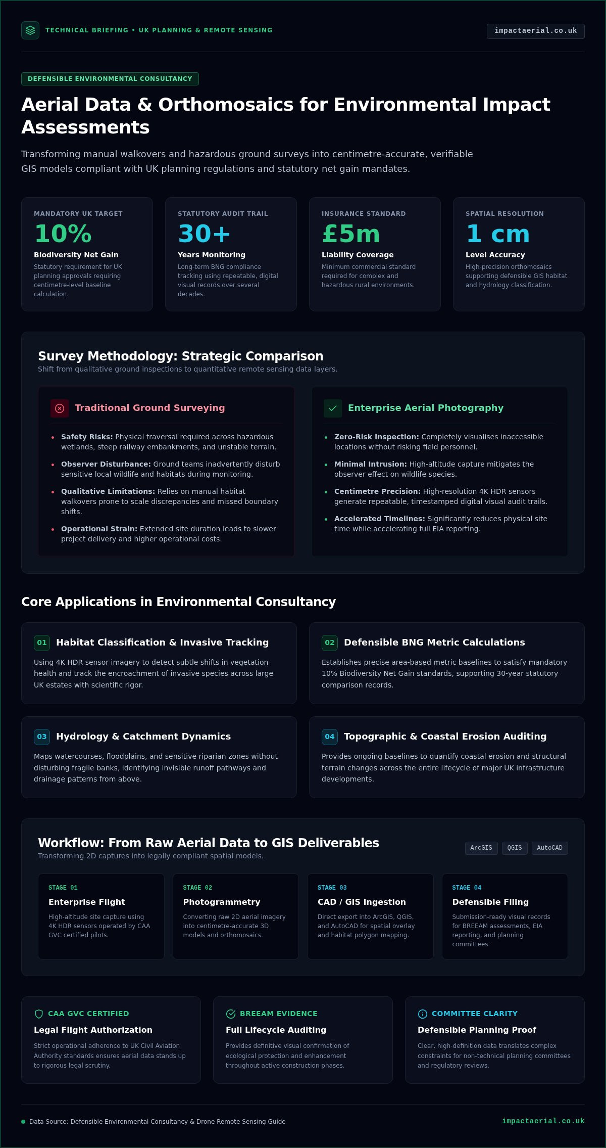
This guide demonstrates how professional aerial photography for environmental consultants transforms these challenges into streamlined, high-resolution workflows. By integrating advanced drone data, you can achieve the accuracy required for mandatory 10% Biodiversity Net Gain (BNG) assessments while significantly reducing site time. We will explore the shift toward centimetre-accurate orthomosaic maps for GIS, faster Environmental Impact Assessment (EIA) delivery, and the necessity of using CAA GVC certified pilots. You’ll learn how to secure legally compliant data that strengthens planning applications and ensures your projects remain on schedule and within budget.

Key Takeaways

  • Learn how high-resolution data ensures compliance with the mandatory 10% Biodiversity Net Gain (BNG) requirement for UK planning applications.
  • Discover how professional aerial photography for environmental consultants produces centimetre-accurate orthomosaics for precise habitat and hydrology mapping.
  • Understand why advanced enterprise-grade drone hardware is essential for maintaining data integrity and meeting rigorous technical reporting standards.
  • Master the workflow of converting raw 2D aerial imagery into actionable 3D models compatible with ArcGIS, QGIS, and AutoCAD.
  • Identify the critical safety credentials, including CAA GVC certification and £5m liability insurance, required for surveying complex or hazardous rural environments.

The Strategic Value of Aerial Photography for Environmental Consultants

High-resolution data serves as more than just a visual aid; it’s the technical foundation for a robust Environmental Impact Assessment (EIA). While traditional ground-based surveys have their place, they’re increasingly insufficient for the scale and complexity of modern UK developments. The industry is seeing a decisive shift from qualitative visual checks toward quantitative remote sensing data. By integrating professional aerial photography for environmental consultants, teams gain access to precise, measurable insights that ground teams simply can’t match within the same timeframe. This transition to a data-first approach reduces site time and drastically improves consultant safety by removing the need to physically traverse hazardous or unstable terrain. Clear, high-definition imagery also enhances stakeholder communication, making complex environmental constraints easy to understand for non-technical planning committees.

Overcoming Traditional Survey Limitations

Professional drone hardware allows environmental teams to visualise inaccessible areas like deep wetlands, dense ancient woodland, or steep railway embankments without risking personnel. It also mitigates the “observer effect” on local wildlife. Ground-based teams often inadvertently disturb the very species they’re trying to monitor. In contrast, high-altitude capture using aerial photography allows for ecological monitoring that’s far less intrusive. This technology creates a repeatable, timestamped visual record. You can return to the exact same coordinates month after month to provide a verifiable audit trail for long-term monitoring projects. Having this consistent data set is vital for identifying subtle changes in vegetation health or habitat encroachment over several seasons. Precision matters.

Meeting Modern Compliance Standards

The introduction of mandatory 10% Biodiversity Net Gain (BNG) in England has raised the bar for data accuracy. Professional aerial photography for environmental consultants provides the high-resolution baseline needed to calculate these gains with confidence. This data serves as defensible evidence during planning committees and regulatory reviews, where vague descriptions aren’t enough. For projects targeting BREEAM certification, comprehensive site documentation from the air offers a clear record of ecological protection and enhancement measures throughout the construction lifecycle. Relying on CAA GVC certified pilots ensures that all data is captured within the strict legal frameworks required for formal planning submissions. This level of compliance is essential for mitigating risk and ensuring that project data stands up to legal scrutiny.

Core Applications: From Habitat Mapping to Hydrology

The application of aerial photography for environmental consultants extends far beyond simple site overviews. High-resolution orthomosaics allow for meticulous habitat classification that manual walkovers often miss due to scale or perspective. By using 4K HDR sensors, consultants can identify subtle changes in vegetation health or track the encroachment of invasive species across large UK estates with precision. This data provides a technical baseline for topographic changes and coastal erosion monitoring throughout a project’s lifecycle, ensuring that environmental shifts are documented with scientific rigor. Digital surveys capture every detail of the terrain, enabling a level of analysis that traditional methods simply can’t replicate within the same budget.

Biodiversity Net Gain (BNG) Monitoring

Establishing an accurate baseline is the most critical step in meeting the mandatory 10% Biodiversity Net Gain (BNG) requirement for UK developments. Aerial data allows you to calculate area-based metrics with centimetre-level precision, providing a defensible starting point for planning applications. Because BNG requires ongoing monitoring for at least 30 years, having a repeatable, digital visual record is invaluable. It’s a tool that allows for consistent comparison over decades, proving that the promised ecological enhancements are actually being delivered on the ground. This long-term data integrity is vital for maintaining project compliance and stakeholder trust.

Hydrology and Catchment Management

Managing watercourses and floodplains requires a comprehensive understanding of catchment dynamics. Aerial surveys identify drainage patterns and potential runoff risks that are invisible from ground level. You can map sensitive riparian zones and assess watercourse health without disturbing fragile banks or local ecosystems. This non-invasive approach is particularly useful for visualising floodplain dynamics during the early stages of environmental planning. When you need to present complex hydrological data to regulatory bodies, professional aerial photography for environmental consultants offers the clarity required for successful planning approvals. Utilising professional aerial data collection ensures your GIS outputs are built on a foundation of accuracy and regulatory compliance.

Aerial Photography Guide for Environmental Consultants

Technical Standards: Hardware, Sensors, and UK Compliance

Precision in environmental reporting starts with the hardware. While hobbyist drones produce visually pleasing images, professional data collection requires industrial-grade equipment designed for repeatability and accuracy. High-resolution 4K HDR sensors are non-negotiable in this field. These sensors provide the dynamic range necessary to distinguish between subtle vegetation shades or identify small invasive species in varying light conditions. Relying on DJI Enterprise hardware ensures flight stability and data integrity, offering integrated GPS accuracy that consumer models simply cannot match. This technical distinction is vital when your findings must stand up to scrutiny during a public inquiry or a formal planning committee meeting.

Risk mitigation is equally important. Professional operators carry £5m commercial liability insurance as an industry standard. This coverage provides the necessary reassurance for consultants working on large-scale infrastructure projects or sensitive habitats. It ensures that every aspect of the operation, from take-off to data delivery, is backed by a framework of professional accountability. When you commission aerial photography for environmental consultants, you aren’t just buying images; you’re investing in a compliant, technical service that prioritises site safety and data precision.

The Necessity of CAA GVC Certification

The UK drone regulatory framework has undergone significant changes, transitioning from the old PfCO (Permission for Commercial Operations) to the current GVC (General Visual Line of Sight Certificate) and A2 CofC standards. For environmental consultants, hiring a pilot with the correct GVC certification is a legal requirement for many complex operations. This is particularly true when flying near congested areas, public infrastructure, or construction sites. A GVC-certified pilot has demonstrated the advanced flight skills and safety knowledge required to operate within these strict legal boundaries. This certification is your guarantee that the data collection process is fully compliant with Civil Aviation Authority (CAA) regulations, protecting your project from legal delays or liabilities.

Sensor Selection for Environmental Data

Different environmental assessments demand specific sensor capabilities. Standard RGB sensors are the primary tool for high-resolution habitat mapping and general site monitoring. However, complex projects often require more specialised data. Thermal imaging is essential for monitoring nocturnal species or identifying heat signatures in PV solar farm surveys. Multispectral sensors take this further by capturing data across different light wavelengths to assess plant health through NDVI (Normalised Difference Vegetation Index). This level of technical detail allows aerial photography for environmental consultants to provide deep analytical insights into ecosystem vitality and moisture levels that are impossible to capture through traditional photography alone.

Workflow Integration: From Raw Data to GIS Insights

Raw imagery is only the starting point. The true value of aerial photography for environmental consultants lies in the post-production phase, where technical expertise converts thousands of 2D images into centimetre-accurate 3D models and georeferenced maps. This process, known as photogrammetry, uses advanced algorithms to triangulate points across overlapping photos. The result is a high-density point cloud that provides a foundation for detailed environmental analysis. These data sets are designed for immediate use, exporting seamlessly into industry-standard software such as ArcGIS, QGIS, and AutoCAD. This ensures that your environmental findings are integrated into the existing project ecosystem without manual digitisation errors.

Beyond technical mapping, virtual tours provide stakeholders with immersive site walkthroughs that static photos can’t match. These tours allow planning committees and clients to visit the site remotely, viewing environmental constraints from any angle. For long-term projects, archiving this data creates a robust audit trail for environmental compliance. It provides an indisputable record of site conditions at specific intervals, which is essential for defending against potential regulatory challenges or verifying mitigation measures years after project completion.

Creating Accurate Orthomosaics

Developing a reliable orthomosaic requires a methodical three-step technical workflow. First, we plan autonomous flight paths to ensure consistent overlap, typically 75% to 80%, which is critical for stitching accuracy. Second, the imagery is processed through photogrammetry software to create a single, georeferenced map that accounts for lens distortion and terrain relief. Finally, this aerial data is overlaid with existing topographical surveys to provide a comprehensive view of the site. This layered approach ensures that your GIS insights are both visually clear and spatially accurate.

Interactive Data and Reporting

Modern environmental reporting demands more than just text and tables. High-impact aerial videography and 3D terrain models bring client reports to life, making them more persuasive during stakeholder engagement and public consultations. These interactive assets help non-experts visualise complex environmental data, such as flood risk zones or habitat corridors. By integrating high-resolution data into your existing drone survey workflows, you ensure that every project phase is backed by defensible, technical evidence. If you’re ready to enhance your reporting precision, you can book a consultation for our technical data collection services today.

Choosing an Aerial Partner for Environmental Projects

Selecting a provider for aerial photography for environmental consultants requires a shift in perspective. You aren’t simply hiring a photographer; you’re engaging a technical partner who understands the rigours of Environmental Impact Assessments (EIAs) and the legal weight of planning data. The UK’s rural environments present unique challenges, from unpredictable weather patterns to complex airspace near infrastructure. A partner must demonstrate more than just flight skill. They need a deep understanding of how to capture data that is spatially accurate and legally defensible. This expertise ensures that the data collected serves as a reliable foundation for your professional reporting.

What to Look for in a Drone Service Provider

The first step in your evaluation is verifying regulatory compliance. You must check for CAA GVC certified status and ensure the provider carries at least £5m in commercial liability insurance. Beyond paperwork, scrutinise their portfolio for technical environmental data collection rather than just cinematic marketing shots. High-resolution habitat mapping requires different flight parameters than creative filming, such as specific overlap percentages and consistent altitudes. Finally, ensure they utilise commercial-grade DJI Enterprise hardware. These platforms are built for the stability and sensor precision required to produce centimetre-accurate orthomosaics. Using consumer drones for professional environmental reporting risks data degradation and project delays.

Partnering with Impact Aerial

Impact Aerial operates as a technical consultant to your environmental team. We don’t just provide raw files; we deliver actionable insights through meticulous post-production and data processing. Our pilots are experts in navigating hazardous or inaccessible terrain, ensuring that your ground teams remain safe while we capture the necessary site data. With our national UK coverage and local expertise from our West Midlands base, we provide a responsive service that aligns with your project timelines. This local grounding allows us to understand regional planning nuances while maintaining a national standard of excellence.

We integrate seamlessly with your existing workflows, providing data that slots directly into your GIS or CAD software. Our commitment to safety and precision means you can trust the integrity of every map, model, and report we generate. This professional approach provides the psychological comfort and tangible business benefits needed to secure planning approvals and meet BNG targets. If you’re ready to elevate your project data, Contact Impact Aerial for a professional drone survey quote to discuss your specific requirements.

Elevating Environmental Data with Precision Aerial Insights

The shift toward data-driven environmental reporting is no longer optional for UK consultants. High-resolution orthomosaics and 3D terrain models provide the defensible evidence required for mandatory 10% Biodiversity Net Gain (BNG) targets and complex planning applications. By moving beyond traditional ground surveys, you eliminate safety risks in hazardous terrain while gaining centimetre-accurate insights that integrate directly into your GIS workflows. These technical assets ensure your findings stand up to the most rigorous regulatory scrutiny.

Implementing aerial photography for environmental consultants requires a partner who prioritises technical compliance and data integrity. Working with CAA GVC certified pilots ensures your project adheres to strict UK aviation regulations, while £5m public liability insurance provides the necessary operational reassurance. Our use of DJI Enterprise 4K HDR drones guarantees that every pixel contributes to a robust, professional report. This meticulous approach to data collection allows your team to focus on analysis rather than manual mapping.

Precision data is the foundation of successful environmental stewardship and project approval. We are ready to help you transform your site surveys into powerful analytical assets. Request a Technical Consultation for Your Environmental Project today and secure the high-tier data your consultancy deserves. We look forward to supporting your next project with expert aerial insights.

Frequently Asked Questions

Is a specific drone license required for environmental surveys in the UK?

Yes, a specific qualification is necessary for professional environmental surveys in the UK. Commercial operators must hold a General Visual Line of Sight Certificate (GVC) or an A2 Certificate of Competence (A2 CofC) issued by the Civil Aviation Authority. These certifications ensure the pilot understands the legal framework and safety protocols required for complex site work. Hiring a GVC certified pilot provides the legal assurance that your data collection is compliant with current national aviation standards.

How accurate is drone data for land-use mapping compared to traditional methods?

Drone data offers significantly higher precision than traditional manual walkovers, especially across large or complex terrains. When using professional hardware, we achieve centimetre-level accuracy in our orthomosaic maps. This level of detail is essential for aerial photography for environmental consultants who need to calculate precise habitat areas for Biodiversity Net Gain (BNG) assessments. It replaces the estimations of ground surveys with georeferenced, technical data that integrates directly into GIS software for exact land-use classification.

Can drones be used for nocturnal wildlife monitoring?

Yes, drones equipped with advanced thermal sensors are highly effective for monitoring nocturnal species without causing significant disturbance. These sensors detect heat signatures against the cooler ground, allowing consultants to track wildlife movement or identify roosting sites in total darkness. This non-invasive method provides a safer and more efficient alternative to traditional night-time ground surveys. It’s particularly useful for protected species surveys where maintaining a distance is critical for ethical and legal compliance.

What insurance coverage should an aerial photographer have for commercial sites?

A professional aerial service provider should carry a minimum of £5m in commercial liability insurance for work on environmental or commercial sites. This level of coverage is considered the industry standard for commercial operations in the UK. It protects both the consultant and the client against unforeseen incidents during data collection. We maintain this high level of indemnity to provide psychological comfort and ensure our operations meet the strict risk assessment requirements of large-scale infrastructure projects.

How does weather affect aerial photography for environmental projects?

Weather conditions play a critical role in flight safety and data quality. High winds, heavy rain, or thick fog generally prevent drone operations to protect the hardware and ensure data integrity. However, overcast conditions are often ideal for aerial photography for environmental consultants because they provide soft, consistent lighting without harsh shadows. This uniformity makes it easier to stitch images together and accurately identify vegetation types across a site. We monitor local forecasts meticulously to schedule flights during optimal windows.

What file formats are typically provided for GIS integration?

We provide data in various industry-standard formats to ensure seamless integration with your existing software. For 2D mapping and orthomosaics, GeoTIFF files are the standard for ArcGIS and QGIS. If you require 3D terrain models or topographic data, we can deliver files in .obj, .dxf, or .las formats for use in AutoCAD. These technical outputs allow environmental consultants to overlay aerial data with historical site maps and topographical surveys without any loss of spatial accuracy.

Are drones allowed to fly over protected SSSI sites?

Drones can operate over Sites of Special Scientific Interest (SSSI), but the process requires careful planning and specific permissions. You often need to secure consent from Natural England or the relevant local authority before take-off. Professional operators conduct thorough risk assessments to ensure the flight doesn’t disturb sensitive habitats or nesting birds. Using a certified pilot ensures that these legal requirements are managed correctly, providing a non-invasive way to monitor these protected areas without physical site entry.

How much does a professional aerial survey cost for a consultant?

Professional survey costs vary based on the site’s geographic size, the complexity of the terrain, and the specific data outputs required. A simple habitat map for a small planning application involves different resources than a multi-day survey of a large industrial estate. We provide bespoke quotes tailored to your project’s technical needs. Factors like sensor selection and post-production processing time also influence the total investment. Requesting a specific project estimate ensures your budget aligns with the data quality needed.