
Drone photogrammetry services in the UK are only as dependable as the planning behind the data capture. For a construction team, that means defining the information needed and planning a safe flight suited to the site.
Look beyond the images: ask who will fly, what insurance is in place and how the work will be coordinated around an active site. Survey outputs can help teams document conditions, monitor change and compare progress with drawings, but the capture plan must suit the project.
This guide explains what construction drone surveys can deliver, how pilots approach CAA authorisation and insurance, and how privacy and site safety are considered. It also introduces common outputs, including orthomosaics and 3D models, and the factors that shape a survey brief, so you can understand what to expect before planning aerial monitoring for your project.
Key Takeaways
- Match the survey plan to the construction task, whether you need progress records, measurements or comparisons with drawings.
- Choose the right output for the work: orthomosaics, point clouds, 3D meshes and surface models serve different project needs.
- Plan image capture with residents and neighbouring properties in mind, and consider how the site layout affects data collection.
- Before a flight, understand how the pilot handles CAA authorisation, insurance and safety around an active construction site.
Drone surveying for construction and house building
Construction teams use aerial surveys to record site conditions and monitor changes as work progresses. Photogrammetry can support measurements, earthwork calculations and comparisons with project drawings.
Survey Deliverables and Turnaround
Deliverables depend on the survey brief and may include precision imagery, site recordings, orthomosaics or 3D models. For example, teams can compare repeat surveys to quantify earth moved, or inspect roof and façade imagery for visible condition changes.
The work includes planning, on-site capture, processing and preparing the agreed outputs. Clarify the delivery schedule and whether you need a single site record or repeat monitoring at construction milestones.
CAD Drawings and Survey-Ready Data
Survey data can be compared with CAD or PDF drawings to review site conditions against the design. Before capture, identify the drawing revision, survey area and comparison required. This helps ensure the resulting data supports a defined project task.
For house building, teams can compare completed work with architects’ drawings and flag discrepancies for review. Agree which data and drawing references to use, then make sure the final deliverables suit the project team’s review process.
Weather Considerations for Drone Surveys
Weather affects when a flight can take place and the quality of the imagery. Wind can affect flight stability, while rain or poor visibility can make safe capture and clear site records more difficult.
Build flexibility into the site programme, especially when earthworks or access conditions are changing. Review the forecast and site conditions before capture, and plan for a suitable flight window rather than relying on a fixed date regardless of conditions.
Project Cost and Turnaround Factors
Project cost and turnaround depend on the survey area, site complexity, access, required outputs and processing scope. A single progress record differs from repeat monitoring or a survey that needs CAD comparisons, roof imagery and façade coverage.
To plan the work, define the site boundary, purpose, deliverables and required delivery date in the brief. Those details help set the capture and processing scope; weather and site readiness can also affect scheduling and completion time.
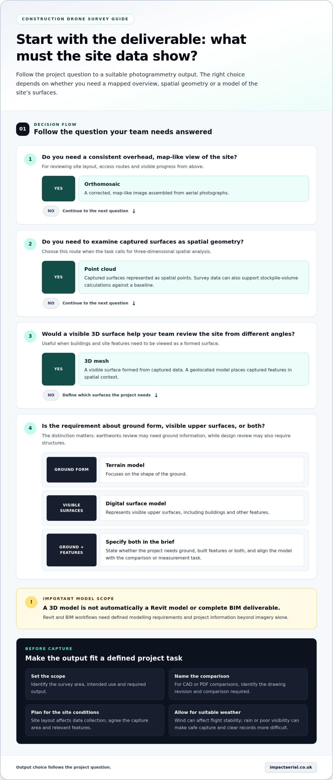
Orthomosaics, point clouds, 3D meshes and surface models
UK drone photogrammetry can produce orthomosaics, point clouds, 3D meshes and surface models. The right output depends on whether the project needs a mapped overview, measurable geometry or a digital representation.
Orthomosaics and Point Clouds
An orthomosaic combines aerial images into a corrected, map-like view of a site. Construction teams can use it to review the layout, access routes and visible progress from a consistent overhead perspective. A point cloud represents captured surfaces as spatial points, helping teams examine geometry in three dimensions.
Choose the output to match the task: an orthomosaic suits visual site review, while a point cloud supports spatial analysis. Drone survey data can also be used to calculate stockpile volume against a baseline, helping teams track material quantities between surveys.
3D Meshes and Geolocated Models
A 3D mesh forms a visible surface from captured data, making buildings and site features easier to view from different angles. Geolocated models place captured features in a spatial context, which helps project teams compare locations and communicate findings. Specify the area and intended use before capture so the model addresses a defined project need.
For example, a modular housing development model was created using more than 2,500 drone images. A model can support visual review, but it does not automatically constitute a Revit model or a complete BIM deliverable. Revit and BIM workflows need defined modelling requirements and project information beyond imagery alone. For property review, survey outputs for commercial properties can help teams assess what visual data will serve their project.
Surface and Terrain Models
A digital surface model represents visible upper surfaces captured across an area, including buildings and other features. A terrain model focuses on ground form. This distinction matters: a house-building team reviewing earthworks needs ground information, while a design review may also require structures to be represented.
Topographical survey information can be converted from 2D into 3D and displayed as a 3D surface. Define whether the project needs ground, built features or both, then align the requested model with the comparison or measurement task. That gives the survey team a clear basis for preparing useful digital data.
Will the drone photograph residents or neighbouring properties?
Photogrammetry records images across a planned survey area, so the flight plan should define the construction boundary and relevant features. Accuracy depends on image quality, coverage, processing and project control data. LiDAR and traditional surveying use different measurement methods, so no method is universally more accurate.
For a construction site beside homes, agree the capture area before the flight. Plan the route and camera direction around the required land, buildings or access areas, rather than collecting broad imagery without a project purpose. This keeps capture focused while recording the features needed for the work.
Photogrammetry uses overlapping photographs to create measurable outputs, such as a surface model. Clear, consistent imagery helps represent visible surfaces, while obscured ground, repetitive textures or moving objects can affect the results. Open ground with visible earthworks presents different capture conditions from a crowded plot with trees and active plant.
LiDAR collects distance measurements using laser returns and can be useful for land topography and terrain information. It can support cut-and-fill calculations alongside photogrammetry; the right approach depends on site cover, required detail and intended analysis. For example, a team assessing earth moved can compare repeat survey data with a baseline.
To account for residents and neighbouring properties, mark the work boundary and sensitive viewpoints in the survey brief. The operator can plan the flight path and camera framing around the required site features, then review the captured material against the agreed deliverable. For a roof survey near adjacent homes, the plan can prioritise the target roof and avoid unnecessary views beyond it.
Traditional surveying remains useful when a project needs specific ground measurements or established control points. Drone imagery offers broader visual coverage, while LiDAR provides another route to spatial data. Define the accuracy requirement, area, surface conditions and intended use first. These criteria help determine the collection method and data checks that fit the survey.
CAA authorisation, insurance and site safety
Commissioning a survey starts with the site, purpose and required outputs. The operator then plans the flight, reviews airspace and access, assesses site risks and agrees the capture arrangements before attending.
Ask about pilot qualifications and how the planned operation will be assessed. Impact Aerial’s pilots are CAA-GVC Certified, and the company holds full UK CAA Operational Authorisation. Authorisation and operational planning need to be considered for the specific location and task, rather than treated as generic permission for every flight.
Insurance is another practical part of commissioning. Construction teams should establish how survey activity fits the site’s access arrangements, working zones and contractor coordination. For example, a flight over an active build needs a clear plan for people, plant and the drone’s operating area.
Key operational considerations include changing weather, nearby airspace constraints, privacy and activity on the ground. Wind or poor visibility can affect capture conditions; site teams can help by identifying moving plant, restricted areas and schedule changes. A neighbouring property or occupied building calls for a focused capture plan that limits imagery to what the survey requires.
Before commissioning, provide the site location, boundary, purpose, preferred date and required deliverables. Identify access points, active work areas, nearby residents and known airspace concerns. The operator can use these details to plan the flight and explain the authorisation and safety arrangements for that operation. Insurance documents and pilot credentials can also be discussed as part of the project.
Keep the decision practical: establish who coordinates site access, how workers are informed, and what happens if conditions change. These steps connect the flight plan to real construction activity, rather than treating aerial capture as separate from site management. Discuss a construction drone survey with the team before setting the site programme.
Impact Aerial: Aerial Filming and Photography
Impact Aerial provides aerial filming and photography for construction teams that need clear visual records of a site. Construction Site Monitoring helps teams review changing conditions and communicate updates. Drone Commercial Property Surveys are suited to visual inspections of commercial buildings, while PV Solar Farm Thermal Surveys address a different specialist inspection need.
Choose the service to match the project outcome: scheduled site visuals, building imagery or thermal survey information. A clear brief covering the site, intended use and required output helps shape the work. Impact Aerial’s aerial services are a practical option when a construction team needs professionally captured views for monitoring, review or communication.
To discuss aerial filming and photography for your project, contact Impact Aerial or visit impactaerial.co.uk.
Plan your next project with confidence
Turn your survey requirement into a practical project brief by identifying the decision the data needs to support. For example, specify whether you need to document construction progress, assess a commercial property or inspect a solar farm. This helps define the scope for drone photogrammetry services in the UK and keeps the project focused on useful outcomes.
Impact Aerial offers Aerial Filming and Photography, Drone Commercial Property Surveys and PV Solar Farm Thermal Surveys. Consider which service matches your site and intended use, then share the project context, access considerations and preferred deliverables. A clear brief gives the discussion a useful starting point without assuming every site needs the same approach.
Contact Impact Aerial about your site to discuss the right aerial service for your project. A considered first step can help you move forward with clarity.
Frequently Asked Questions
Are your pilots licensed and insured?
Yes. For a construction project, include the site location and intended flight in the planning discussion. Pilot credentials sit alongside operational planning, helping site managers coordinate drone activity with access arrangements and existing site controls.
Do you cover the whole UK?
Impact Aerial is based in Birmingham and the West Midlands and provides services across the UK. For a project elsewhere, include the site location, access arrangements and preferred survey dates in your initial brief. These details help shape travel and capture planning, while construction activity and local surroundings inform how the survey is organised.
What happens if the weather is bad?
Wind, rain or poor visibility can make a planned flight unsuitable for safe operation or clear image capture. Build flexibility into the site programme and coordinate a suitable alternative capture window with the project team. Keep access details and deliverable priorities to hand so a weather-related schedule change can be managed alongside site activity.
Which UK companies provide drone photogrammetry services, and where do they operate?
Impact Aerial provides drone services across the UK from its base in Birmingham and the West Midlands. Relevant services include Construction Site Monitoring, Drone Commercial Property Surveys and Aerial Filming and Photography. The right service depends on whether the project needs recurring progress visuals, commercial property imagery or another defined aerial outcome. Include the site location and intended use in your enquiry.
What deliverables do UK drone photogrammetry services provide, such as orthomosaics, 3D models and point clouds?
A survey brief can specify an orthomosaic for mapped site viewing, a point cloud for spatial analysis, or a 3D mesh or model for visualising form. Surface models can support terrain or built-feature review, and data can be compared with drawings or earlier captures. Impact Aerial’s stated capabilities include 3D imaging and detailed topological graphics; the requested format should suit the project’s intended use.
What UK CAA rules and permissions apply to commercial drone photogrammetry?
CAA requirements and authorisation should be considered for the planned operation and site, rather than inferred from commercial purpose alone. Impact Aerial’s pilots are CAA-GVC Certified, and the company holds full UK CAA Operational Authorisation. Site location, surrounding airspace, people and ground activity are practical planning considerations. Include the precise site and survey task in your project brief.
 2 Norton Drive, Wythall, Birmingham, B47 6HH Company registration number: 11138586. VAT Number: 366 9068 55


