
Drone Surveyor Birmingham: The Professional Guide to Aerial Inspections

The traditional roof survey is rapidly becoming an expensive relic for Birmingham’s commercial property sector. You’ve likely felt the frustration of paying for weeks of scaffolding or hiring MEWPs just to identify a minor leak, all while worrying about the safety risks of manual inspections. Partnering with a professional drone surveyor birmingham allows you to bypass these high-cost, high-disruption methods that often feel outdated in a modern, data-driven world.

Professional aerial inspections solve these logistical bottlenecks by delivering precision data without the site downtime. We agree that your priority is maintaining site safety while securing accurate, actionable building reports. This guide demonstrates how drone technology provides 4K HDR visual clarity and thermal insights with zero disruption to your daily operations. You’ll learn about the technical requirements, from CAA GVC certifications to £5m liability insurance, ensuring your project remains fully compliant, meticulously documented, and safer for everyone involved.

Key Takeaways

  • Discover how aerial inspections significantly reduce project lead times and overheads by removing the need for costly scaffolding and heavy machinery.
  • Understand the technical advantages of using DJI Enterprise hardware with 4K HDR sensors to identify minute structural defects that are often missed by ground-based surveys.
  • Identify the essential regulatory requirements for hiring a professional drone surveyor birmingham, including the necessity of CAA GVC certification and £5m commercial liability insurance.
  • Explore how professional drone surveying ensures zero-disruption to site operations, allowing your business to continue as normal during complex structural assessments.
  • Learn how high-resolution survey data is processed through professional post-production to create detailed, authoritative, and actionable building reports.

Why Drone Surveying is Essential for Birmingham Property & Construction

Birmingham’s skyline is a complex mosaic of Victorian heritage, brutalist landmarks, and glass-fronted skyscrapers. Traditional surveying methods often struggle with these tight urban spaces, where erecting scaffolding is both logistically difficult and prohibitively expensive. A professional drone surveyor birmingham provides the agility required to capture data from perspectives that are physically impossible for ground-based teams to reach safely. This technology has transitioned from a niche alternative to a core industry standard across the West Midlands, offering a fusion of technical precision and operational efficiency.

The primary advantage of aerial data collection lies in its non-invasive nature and the unprecedented depth of information it provides. By utilizing high-resolution UAVs, surveyors can identify hairline fractures, displaced tiles, or blocked guttering in a fraction of the time it takes to mobilize a manual inspection team. This speed does not come at the cost of quality; instead, it delivers a level of visual clarity that allows for more informed decision-making and long-term asset management.

To better understand how this technology is applied in professional surveying projects, watch this helpful video:

The Shift in West Midlands Site Management

A drone survey is a non-invasive aerial inspection method that uses unmanned aerial vehicles to capture high-resolution imagery and structural data. In Birmingham, construction leads are increasingly adopting this method for progress monitoring, allowing stakeholders to oversee multi-million pound developments through weekly visual updates. This data is vital for urban planning and large-scale regeneration projects, as it provides a comprehensive overview of how new structures interact with the city’s existing infrastructure and transport links.

Key Applications for Local Commercial Property

The application of drone technology is particularly effective for historic city-centre structures where traditional access might damage fragile masonry. By using photogrammetry, surveyors can create accurate 3D models of listed buildings to plan restoration works with surgical precision. Industrial zones around the city also utilize these surveys for thermal imaging to conduct energy efficiency audits. Meanwhile, in rapidly developing areas like Digbeth, drone data is essential for initial site investigations, providing developers with clear topographical insights before the first shovel hits the ground.

The Technology Behind High-Precision Aerial Data Collection

Precision in aerial surveying isn’t just about the pilot’s skill; it’s about the technical capabilities of the hardware. For a drone surveyor birmingham, the choice of equipment determines whether a structural defect is identified or overlooked. DJI Enterprise drones represent the industry gold standard because they combine airframe stability with sophisticated sensor payloads. These systems are designed to operate within strict Civil Aviation Authority (CAA) regulations, ensuring that every flight is both legal and safe while capturing high-fidelity data.

Hardware Spotlight: DJI Enterprise Capabilities

The ability to maintain flight stability is critical when navigating Birmingham’s narrow urban corridors and high-rise wind tunnels. DJI Enterprise hardware excels here, providing a steady platform for high-zoom lenses that allow for detailed asset inspection from a safe standoff distance. This means surveyors don’t need to fly dangerously close to structures to capture minute details. If you’re interested in the specific technical specs of these aircraft, you can read our guide on survey drones to see how they differ from consumer models.

While some competitors focus solely on laser scanning, the value of 4K HDR visual data shouldn’t be underestimated. High dynamic range sensors capture details in both deep shadows and bright highlights, which is essential for spotting hairline fractures in masonry or corrosion on metal roofing. This visual clarity is complemented by thermal imaging sensors, which are indispensable for PV solar farm surveys. These sensors detect “hot spots” in solar panels or identify significant heat loss in industrial units, providing a layer of data that the human eye simply cannot see.

From Raw Data to Post-Production Excellence

Every professional drone surveyor birmingham knows that raw footage is rarely enough for a commercial stakeholder to make a critical decision. The transition from raw data to an actionable report happens in post-production. Professional editing clarifies findings, highlights areas of concern, and organizes hours of flight time into concise, high-impact video summaries. This process makes the data easier for stakeholders to digest and act upon quickly.

This technical workflow often includes creating immersive virtual tours, which allow property managers to remotely inspect a site from any location. This level of documentation provides a permanent, high-resolution record of a building’s condition that traditional methods cannot match. If you need this level of detail for your next project, our team provides comprehensive drone commercial property surveys tailored to the specific needs of the West Midlands market.
Drone Surveyor Birmingham: The Professional Guide to Aerial Inspections

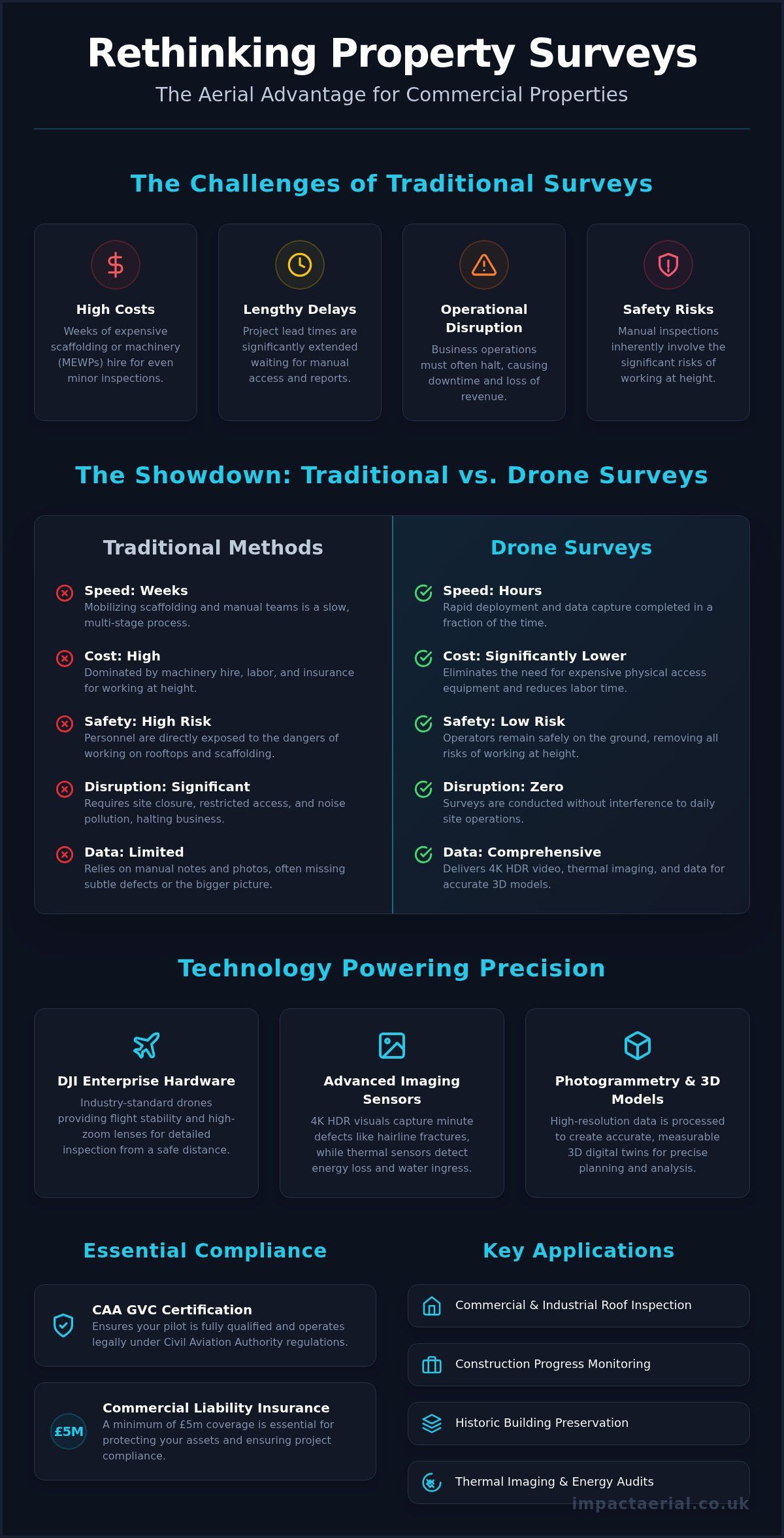
Drone Surveys vs. Traditional Access: Cost, Safety, and Speed

Choosing a drone surveyor birmingham transforms how structural health is assessed by removing the single greatest liability in the construction industry: working at height. Traditional inspections often require personnel to navigate precarious rooflines or balance on ladders to get a clear view of defects. By keeping boots on the ground, property managers significantly reduce their risk profile while obtaining superior data from angles that were previously inaccessible.

Speed is another critical differentiator that makes aerial methods the modern standard. While a manual inspection of a large Birmingham warehouse might take days of preparation and execution, an aerial survey is often completed in just a few hours. This rapid turnaround allows for faster reporting and quicker remedial action, which is vital when dealing with active leaks or structural instability that could worsen during the time it takes to organize traditional access.

Financial efficiency is perhaps the most tangible benefit for commercial clients. Some industry professionals report that drone surveys typically cost between 60% and 70% less than traditional scaffolding or MEWP (Mobile Elevated Work Platform) hire. This financial saving is coupled with the benefit of zero disruption; your business remains fully operational without the sight of steel poles or the obstruction of essential parking spaces and site access routes.

The Safety Advantage

Safety isn’t just about avoiding falls; it’s about data integrity and liability management. Using professional drone services ensures that even the most unreachable areas, such as church spires or high-rise facades, are inspected without physical contact that could damage fragile historic masonry. All operations are conducted under strict Civil Aviation Authority regulations, providing an additional layer of professional reassurance and legal compliance for corporate clients and insurers.

Economic Impact for Property Managers

For property managers, the return on investment for aerial monitoring is found in early defect detection. Identifying a loose tile or a blocked valley gutter through regular surveys prevents the catastrophic costs of internal water damage and business interruption. Often, these maintenance tasks require the expertise of tradespeople who have qualified through an intensive plumbing course UK to ensure long-term property maintenance. Additionally, drones eliminate the logistical nightmare and high fees associated with city-centre road closures often required for large cherry pickers. A drone can be deployed and complete a full roof survey in the time it takes a scaffolding team to merely unload their equipment and begin assembly.

Operating a drone in a densely populated urban centre like Birmingham requires more than just technical skill; it demands a deep understanding of the legal framework established by the Civil Aviation Authority (CAA). For a drone surveyor birmingham, compliance isn’t a checkbox but a prerequisite for every flight. Urban environments present unique challenges, such as proximity to pedestrians and the complexities of Birmingham City Council’s specific land-use policies. A professional operator must conduct rigorous risk assessments to mitigate these factors before the aircraft even leaves the ground.

The city’s geography adds layers of complexity that hobbyists simply aren’t equipped to handle. From the high-rise corridors of the city centre to the sensitive airspace surrounding Birmingham Airport, every flight path must be meticulously planned. Professional surveyors use specialized software to identify “No Fly Zones” and temporary flight restrictions, ensuring that your project doesn’t inadvertently breach national aviation laws. This level of preparation provides the psychological comfort that your business is protected from both legal repercussions and safety incidents.

The Importance of CAA Certification

The General Visual Line of Sight Certificate (GVC) is the non-negotiable standard for commercial drone operations in the UK. Unlike hobbyist flyers, GVC-certified pilots have undergone rigorous theoretical and practical examinations to prove their competence in complex environments. This certification is particularly vital when managing flights within controlled airspace or near congested areas. For a detailed breakdown of these requirements, you can consult our UK drone license guide, which explains the current 2026 standards and what they mean for commercial clients.

Commercial liability insurance is the bedrock of professional reassurance. While basic cover might suffice for rural flights, the industry minimum for urban surveying is £5m. This level of protection ensures that property owners and site managers are fully shielded against unforeseen incidents. It’s essential to verify that your chosen surveyor holds specific commercial drone insurance rather than a generic public liability policy, as the latter often excludes aviation-related risks.

A Checklist for Hiring Your Drone Surveyor

To ensure your project is handled with the necessary technical and legal precision, follow this vetting process:

  • Verify CAA credentials: Ask for the operator’s Flyer ID and Operator ID, and confirm their GVC status is current.
  • Review Birmingham-based projects: Experience in the local West Midlands landscape ensures they understand specific city-centre flight corridors and local restrictions.
  • Confirm sensor capabilities: Ensure their hardware, such as DJI Enterprise models, matches the specific data depth you require for structural or thermal analysis.
  • Evaluate the data delivery plan: Confirm how the raw footage will be processed into an actionable survey report that your stakeholders can easily interpret.

If you require a fully compliant aerial inspection for your site, our team provides drone commercial property surveys that adhere to the highest safety and regulatory standards in the West Midlands.

Impact Aerial: Your Leading Drone Survey Partner in the West Midlands

Impact Aerial operates as a specialized drone surveyor birmingham, providing a seamless bridge between raw technical data and high-end visual reporting. Being based directly in the West Midlands gives us an intimate understanding of the local architectural landscape and the specific regulatory requirements of the region. We don’t just capture imagery; we provide a comprehensive end-to-end service that manages every aspect of your project, from the initial airspace risk assessment to the final post-production edit.

Our methodology focuses on delivering psychological comfort through meticulous compliance. We understand that commercial clients require more than just a drone in the air; they need the assurance that comes with CAA GVC certified pilots and £5m commercial liability insurance. This professional foundation allows us to operate in complex Birmingham city-centre environments while maintaining the “zero disruption” standard that modern site management demands.

Our Local Expertise

Our track record in Birmingham includes a wide range of commercial property surveys and large-scale construction site monitoring projects. We utilize DJI Enterprise 4K HDR hardware to ensure that every pixel of data is sharp, clear, and actionable for your engineering teams. Beyond technical surveys, our expertise in drone photography for construction allows us to provide stakeholders with visually stunning progress reports that are as cinematic as they are accurate. This combination of technical precision and visual excellence ensures that findings are easily understood by all project stakeholders.

We offer specialized solutions tailored to the needs of the West Midlands industrial and energy sectors. This includes PV solar farm thermal surveys to identify underperforming cells and detailed property condition reports for historic city-centre assets. By combining technical precision with professional post-production, we turn complex aerial data into immersive virtual tours and structured reports that simplify your decision-making process.

Ready to Start Your Project?

Every site in Birmingham has its own set of challenges, from urban congestion to sensitive airspace near the airport. We begin every project with a thorough consultation to define your specific data and visual requirements. This ensures that the flight plan we develop is optimized for both safety and data depth, providing you with the most relevant information for your asset management needs. If you’re ready to secure faster, safer, and more accurate building data, you can Contact Impact Aerial for a Professional Drone Survey today to request a tailored quote for your site.

Future-Proofing Your Property Strategy with Aerial Intelligence

The transition to drone-led inspections represents a significant advancement for the West Midlands’ property and construction sectors. By replacing slow, hazardous manual methods with high-resolution 4K data, you gain a level of structural insight that was previously unattainable. Choosing a qualified drone surveyor birmingham ensures that your site remains fully operational while you benefit from technical precision that reduces overheads significantly. It’s no longer just an alternative; it’s the professional standard for modern asset management.

We combine deep local knowledge with the highest safety standards to deliver actionable reports. Our team of CAA GVC Certified Pilots operates with £5m Public Liability Insurance, providing the professional reassurance your business requires in complex city-centre environments. You don’t have to compromise on safety or data depth to achieve speed. Book Your Professional Birmingham Drone Survey Today and take the first step toward a safer, more efficient site monitoring process. We look forward to helping you elevate your next project.

Frequently Asked Questions

Do I need a permit for a drone survey in Birmingham city centre?

Professional drone operations in Birmingham city centre require strict adherence to CAA regulations and often specific permissions from the local authority if taking off from public land. A qualified drone surveyor birmingham will conduct a comprehensive risk assessment and handle all necessary notifications before the flight. This meticulous planning ensures your project remains fully compliant with national aviation laws while avoiding potential fines or legal complications associated with unauthorized urban flights.

How much does a professional drone survey cost in the UK?

Professional survey costs are determined by the specific requirements of your site, including the total acreage and the technical depth of the data required. Factors such as the proximity to sensitive airspace and the need for specialized thermal sensors will influence the final investment. We focus on providing a cost-effective alternative to heavy machinery, ensuring the price reflects the high-tier hardware used and the expert post-production necessary to create actionable building reports.

Can drones perform roof surveys in bad weather?

Flight safety and data quality are our primary concerns, so we don’t operate in heavy rain or high winds. Most enterprise-grade drones have specific wind resistance limits, typically around 22mph. If the weather conditions are unsuitable, we reschedule the survey to ensure the 4K HDR imagery is clear and the aircraft remains stable. This commitment to quality ensures the structural defects we identify are captured with absolute precision.

What is the difference between a drone survey and drone photography?

The primary difference lies in the technical intent and the equipment used. Drone photography focuses on aesthetic visuals for marketing or promotional use. In contrast, a survey conducted by a professional drone surveyor birmingham utilizes technical sensors to identify structural defects, thermal leaks, or maintenance requirements. The output is a data-centric report designed for engineers and property managers rather than a creative agency, emphasizing accuracy and structural integrity over visual flair.

How accurate is drone data for topographical land surveys?

When integrated with Ground Control Points (GCPs) and RTK technology, drone data is exceptionally accurate for topographical mapping. It can achieve sub-centimetre horizontal and vertical precision, providing developers with detailed terrain models. This level of accuracy is essential for initial site investigations and construction monitoring, allowing for precise volume calculations and structural alignment checks that match or exceed the results of traditional ground-based surveying methods.

Is drone surveying safer than traditional methods?

Drone surveying is inherently safer because it removes the requirement for staff to work at height. By keeping surveyors on the ground, you eliminate the risks associated with ladders, fragile roof surfaces, and scaffolding. This proactive approach to safety reduces your corporate liability and insurance burden while ensuring that even unreachable structural elements are inspected thoroughly without putting human life at risk during the data collection process.

How long does a typical drone inspection take to complete?

Efficiency is a hallmark of aerial inspections. A typical survey for a commercial warehouse or office block in Birmingham is often completed in two to four hours. This speed allows for minimal site disruption, as there is no need for lengthy equipment setup or road closures. Once the flight is finished, the data is moved into post-production, significantly reducing the total project lead time compared to traditional manual inspection methods.

What deliverables will I receive after a drone survey?

You will receive a comprehensive suite of digital assets tailored to your project goals. This typically includes:

  • High-resolution 4K HDR imagery of structural defects
  • Edited video summaries highlighting areas of concern
  • Thermal maps for energy efficiency audits
  • 3D models or orthomosaic maps for construction sites

All data is processed through professional post-production to ensure the final report is organized, authoritative, and ready for immediate review by your technical stakeholders.

Professional Drone Roof Survey in London: The 2026 Guide to Cost, Safety, and Data

Why are London property managers still paying upwards of £3,000 just to erect scaffolding for a simple visual inspection? In a city where access is restricted and lead times often stretch beyond 21 days, the traditional approach to maintenance is becoming a significant financial liability. A professional drone roof survey london offers a smarter alternative, capturing high-resolution data from chimneys and valleys that often remain invisible from the ground.

You likely already know that scaffolding is not just expensive; it’s a logistical nightmare that disrupts tenants and risks damage to historic masonry. This 2026 guide promises to show you how professional aerial inspections deliver 100% safety and superior data while reducing your survey costs by as much as 70% compared to traditional methods. We’ll examine the latest CAA GVC compliance standards, fixed-cost pricing models, and how our 4K HDR fleet provides the high-resolution condition report you need for total peace of mind.

Key Takeaways

  • Learn why a professional drone roof survey london provides a safer, more cost-effective alternative to traditional scaffolding while delivering superior high-resolution data.
  • Understand how enterprise-grade DJI technology overcomes the unique challenges of London’s micro-climates, wind tunnels, and complex urban architecture.
  • Realise significant cost savings and reduced lead times by switching from weeks of scaffolding setup to just hours of precision aerial flight.
  • Navigate the legal requirements of London’s restricted airspace, including why CAA GVC certified pilots are essential for compliant urban operations.
  • Discover how meticulous risk management and expert post-production analysis provide the peace of mind required for managing high-value London property assets.

What is a Professional Drone Roof Survey in London?

A professional drone roof survey in London is a non-intrusive aerial inspection that utilises advanced Unmanned Aerial Vehicles (UAVs) to capture high-resolution imagery and data of building envelopes. By 2026, the industry has transitioned from basic visual checks to sophisticated, data-driven asset management. This methodology allows for the rapid assessment of structures without the need for expensive scaffolding or high-access equipment, providing a safer and more efficient alternative to traditional methods.

London’s skyline features a unique blend of 18th-century heritage and modern glass structures. Operating within these high-density urban environments requires specialised knowledge of CAA GVC certification and local airspace restrictions. With over 19,000 listed buildings and complex clusters of high-rise developments, a drone roof survey london must account for tight flight paths and stringent safety protocols to ensure every centimetre of the structure is documented accurately.

Standard components of a modern survey include 4K HDR video and high-resolution stills. For added peace of mind, thermal mapping is frequently deployed to identify sub-surface moisture and insulation failures. These sensors detect heat signatures that remain invisible to the naked eye, allowing property owners to pinpoint leaks before they cause structural damage.

The Evolution of Aerial Inspections

Inspections have progressed from basic photography to centimetre-accurate data collection. By 2026, 4K HDR sensors have largely replaced the requirement for physical “hand-on” tile checks in 95% of commercial cases. We use photogrammetry to generate precise 3D models of complex London rooflines. These models allow surveyors to take millimetre-level measurements from their desktop, significantly reducing the time spent on-site while increasing the accuracy of the final report.

Key Industries Benefiting from Drone Surveys

Three primary sectors now rely on drone technology for their property maintenance strategies:

  • Commercial Property Managers: Professionals overseeing the 23 million square feet of office space in central London use drone data for proactive maintenance and insurance valuations.
  • Chartered Surveyors: Experts requiring high-definition visual evidence for RICS condition reports can now access areas that were previously unreachable.
  • Heritage and Residential Blocks: For buildings where scaffolding costs can exceed £5,000 for a simple inspection, a drone roof survey london provides a cost-effective, non-destructive solution that protects the fabric of the building.

The Technology Behind High-Precision London Surveys

Executing a high-precision drone roof survey london requires more than a standard off-the-shelf aircraft. The capital’s unique architecture, coupled with narrow wind tunnels created by skyscrapers in the City and Canary Wharf, demands enterprise-grade stability. Professional operators utilise the DJI Enterprise fleet, such as the Matrice 350 RTK, which is engineered to withstand wind speeds of up to 12 metres per second. These aircraft aren’t just drones; they’re flying workstations equipped with dual-redundancy systems for batteries and flight controllers, ensuring absolute safety when operating over congested urban streets.

The sensor is the heart of the survey. We use large-format sensors that excel in High Dynamic Range (HDR) capture. This is vital for London properties where tall neighbouring buildings cast deep shadows across roof pitches. Without HDR, a standard camera would lose all detail in these dark areas, potentially missing cracks or slipped tiles. For added peace of mind, our professional aerial inspection services provide the technical rigour needed for complex insurance and structural claims.

Enterprise Hardware vs. Consumer Drones

Consumer drones lack the optical zoom capabilities required for safe, detailed inspections. Our enterprise payloads feature up to 200x digital zoom, allowing us to inspect Victorian chimneys and ornate finials from a distance of 15 metres without compromising safety. A global shutter captures the entire frame simultaneously to prevent the motion blur or “jello effect” that occurs with cheaper rolling shutter sensors during flight. This hardware ensures every millimetre of the masonry is sharp and measurable.

  • RTK Positioning: Real-Time Kinematic satellite data provides centimetre-level accuracy for 3D modelling.
  • Obstacle Avoidance: Six-directional sensing prevents collisions in tight London alleyways.
  • IP55 Rating: Allows for data collection in the light rain often encountered during London winters.

Thermal and Multispectral Data

Standard photography only reveals surface issues. We use high-resolution thermal sensors to identify heat loss and moisture ingress that the naked eye can’t see. On commercial flat roofs, wet insulation retains heat differently than dry areas. By flying at dusk, we spot these “hot spots” or “cold spots” that indicate trapped water, preventing costly structural rot. Integrating this data into a wider drone survey workflow allows for a 360-degree view of building health.

Multispectral data adds another layer of intelligence. It identifies the early stages of organic growth, such as moss or lichen, by analysing light signatures invisible to humans. Catching this growth early prevents the premature decay of porous London brickwork and limestone. It’s a proactive approach that moves beyond simple reactive maintenance, giving asset managers a clear 2026 roadmap for their property portfolios.

ROI Analysis: Drone Surveys vs. Traditional Access Methods

The financial risk of deferred maintenance in the capital is substantial. Industry data from 2025 suggests that minor leaks left unaddressed for six months often escalate into structural repairs exceeding £20,000 for mid-sized commercial blocks. For property managers, the “cost of doing nothing” is rarely zero. A drone roof survey london acts as a high-speed diagnostic tool that identifies defects before they necessitate major capital expenditure. While traditional methods require weeks of logistical planning, a drone flight is often completed in a single morning, providing immediate clarity on the building’s health.

  • Lead Times: Scaffolding typically requires 14 to 21 days for permit approvals and assembly. A UAV deployment requires only a few hours of site preparation and flight time.
  • Health and Safety: By removing the need for personnel to work at height, you eliminate the primary cause of workplace fatalities in the UK construction sector. Our operations remain entirely ground-based.
  • Sustainability: Our fleet of electric UAVs produces zero operational emissions. This contrasts sharply with the carbon-heavy logistics of transporting tons of steel scaffolding or operating diesel-powered cherry pickers across London’s Ultra Low Emission Zone (ULEZ).

The Scaffolding Cost Trap in London

In 2026, the hidden expenses of traditional access in London often outweigh the actual labour costs. Pavement licences from local councils like Westminster or the City of London can cost hundreds of pounds per week. Parking suspensions on busy thoroughfares and the mandatory installation of scaffold alarms for security add further layers of expense. Drones serve as the ideal “first-response” method. They allow surveyors to pinpoint a specific leak location. If scaffolding is eventually required, it’s only erected exactly where it’s needed, which saves thousands in unnecessary rental fees and permit extensions.

Data Quality and Shareability

The transition from manual inspections to “digital twins” has revolutionised how data is handled. High-resolution 4K footage and 45-megapixel stills provide a level of detail that a surveyor on a ladder cannot match. This data is easily shared with contractors to secure fixed-price quotes, preventing the budget creep common in complex roof repairs. For storm damage claims, having date-stamped, high-definition evidence accelerates the insurance payout process by providing indisputable proof of the building’s condition. You can find more detail on these efficiencies in this drone roof survey comparison guide. Our CAA GVC Certified pilots ensure that every byte of data gathered meets the highest professional standards, giving you total peace of mind during the claims process.

Operating a professional drone roof survey london involves navigating some of the most strictly regulated airspace in the world. Central London is a patchwork of Flight Restricted Zones (FRZs) protecting Heathrow, London City Airport, and RAF Northolt. Flying within these zones without explicit permission from National Air Traffic Services (NATS) is a criminal offence under the Air Navigation Order 2016. We manage the entire coordination process, liaising with the Metropolitan Police and relevant air traffic control towers to ensure every flight is fully authorised and legal.

Safety in the capital’s congested boroughs like Westminster or Camden requires more than just technical skill. It demands a rigorous approach to risk management. We provide £5 million in commercial liability insurance for every project, offering the necessary protection for high-value commercial assets and the public. This level of cover is a prerequisite for most Tier 1 contractors and property management firms operating in the city. We don’t take risks with your liability or our reputation.

Permissions and Authorisations

Professional operators must hold the correct credentials for urban environments. While a basic drone license might suffice for rural areas, London missions often fall into the “Specific” category. This requires a CAA GVC (General Visual Line of Sight Certificate) and a formal Operating Authorisation. These documents allow us to fly heavier enterprise drones in areas where hobbyist flights are prohibited. We also prioritise privacy and GDPR compliance. Our protocols ensure that any incidental imagery of neighbours or the public is either not captured or is digitally masked during the data processing stage.

Safety Protocols in the Capital

London’s “urban canyons”—areas with tall, glass-fronted buildings—can cause GPS multi-pathing or signal interference. To counter this, we employ a Visual Observer (VO) on every complex drone roof survey london. The VO stays in constant radio contact with the pilot, monitoring the surrounding airspace for helicopters or cranes while the pilot focuses on the high-resolution data capture. Our drones are equipped with advanced obstacle avoidance sensors and redundant battery systems to prevent accidents in high-traffic environments.

  • The 1:1 Rule: In urban drone operations, the 1:1 rule requires the pilot to maintain a horizontal safety distance from uninvolved people that is at least equal to the drone’s current altitude.
  • Emergency Failsafes: Every aircraft is programmed with a “Return to Home” (RTH) protocol that triggers automatically if the command link is interrupted.
  • Pedestrian Management: We use physical cordons and ground marshals in busy boroughs to keep the take-off and landing zones clear of foot traffic.
For a compliant, safe, and fully insured inspection of your property portfolio, book your London drone survey with our expert team.

Choosing Impact Aerial for Your London Roof Survey

Selecting a partner for a drone roof survey london requires more than just finding an operator with a camera. It demands a team that understands the technical and regulatory complexities of the capital’s unique airspace. Impact Aerial brings years of expertise to every project, holding full CAA GVC certification to ensure every flight complies with the latest 2026 aviation standards. Our commitment to safety isn’t just a policy; it’s the foundation of our operations. We conduct meticulous risk assessments for every site, managing everything from pedestrian safety in busy streets to radio frequency interference in dense urban environments.

For added peace of mind, we maintain comprehensive commercial liability insurance, protecting your assets and our team throughout the process. Our end-to-end service ensures you aren’t left with raw data you can’t interpret. We guide you from the initial consultation through to post-production analysis that turns high-resolution imagery into actionable insights. This professional approach is why leading London estate managers and commercial developers trust us with their most sensitive structural assets.

Our Professional Methodology

We begin every project with a pre-flight site survey using advanced satellite data and real-time airspace maps. This allows us to identify potential hazards and flight restrictions before we even arrive on-site. Once we’re there, our pilots behave with the discretion and professionalism expected on a high-value estate or active construction site. You’ll receive a final report featuring high-resolution 4K and HDR imagery, meticulously organised and ready for immediate review by your architect or builder. We provide the technical depth required for precise structural assessments without the need for expensive scaffolding.

Ready to Organise Your Survey?

Waiting for a visible leak to appear is the most expensive maintenance strategy a property owner can adopt. Industry data suggests that reactive repairs often cost five times more than proactive maintenance. Our 3-step booking process makes it easy to stay ahead of structural issues:

  • Step 1: Request a Quote. Contact us for a bespoke London quotation based on your specific property coordinates and requirements.
  • Step 2: Site Execution. Our team handles all flight planning, notifications, and on-site data gathering.
  • Step 3: Data Delivery. Receive your high-resolution data and professional report within 48 hours of the flight.

Don’t leave your roof’s integrity to chance. Contact the Impact Aerial team today to secure your 2026 survey slot. You can also explore our professional drone services to see how we support commercial clients across the wider UK with leading aerial data solutions.

Future-Proof Your Property Maintenance with Precision Aerial Data

As we move into 2026, the transition from costly scaffolding to high-precision aerial intelligence has become a commercial necessity for London property managers. Investing in a professional drone roof survey london eliminates the inherent safety risks of working at height while reducing inspection timelines by up to 70% compared to traditional access methods. Impact Aerial provides the technical expertise required to navigate the capital’s complex Flight Restriction Zones and stringent urban regulations. Our operations are led by CAA GVC Certified Pilots and backed by £5m commercial liability insurance for added peace of mind. We utilise DJI Enterprise grade equipment to capture high-resolution 4K HDR imagery and detailed photogrammetry, identifying structural defects that manual inspections often miss. This data-driven approach ensures your maintenance budgets are spent where they’re needed most. Don’t leave your building’s structural integrity to chance. We’re ready to help you streamline your next inspection with a solution that prioritises safety, compliance, and actionable results.

Request a Bespoke London Drone Roof Survey Quote

Frequently Asked Questions

Do I need permission from the council for a drone roof survey in London?

You don’t usually need permission from the local council for a drone roof survey on private property, but you must comply with Civil Aviation Authority (CAA) flight regulations. Our pilots manage all necessary clearances for Flight Restricted Zones (FRZs) near major hubs like Heathrow or London City Airport. We ensure every operation follows the latest CAP 722 guidelines to guarantee legal compliance and safety for your project.

How much does a drone roof survey cost in London in 2026?

While individual project requirements vary, 2026 industry data from the Drone Safe Register indicates that a standard residential drone roof survey london typically ranges from £250 to £600. Commercial inspections for larger structures involve more complex data-gathering and often start at £800. These figures reflect the high-quality 4K imagery and professional risk assessments included in a standard specialist package for peace of mind.

Can a drone survey detect a leak that isn’t visible to the naked eye?

Drones detect leaks by using thermal sensors to identify moisture trapped under roofing membranes that isn’t visible to the human eye. These radiometric cameras highlight temperature differentials, where damp patches retain heat differently than dry areas. This advanced data-gathering method allows us to pinpoint ingress points with 95% accuracy before they cause structural damage or internal damp issues in your building.

What happens if it rains on the day of my scheduled drone survey?

We’ll reschedule your flight if it rains because moisture can interfere with the drone’s sensitive electronics and obscure the camera lens. Safety is our primary concern, and high winds or precipitation prevent us from capturing the high-quality, stable footage required for a professional report. Our team monitors Met Office forecasts 24 hours in advance to provide you with timely updates and ensure operational success.

Is the drone footage good enough for an insurance company to accept?

Insurance companies and loss adjusters widely accept our drone footage because it provides high-resolution, timestamped evidence of a roof’s condition. We use DJI Enterprise commercial drones to capture 4K HDR imagery that offers more detail than traditional ladder inspections. Since we’re CAA GVC Certified, the data we provide meets the professional standards required for formal claims and detailed structural assessments.

How close to my neighbours’ windows will the drone fly?

Our pilots adhere to strict UK privacy laws and CAA regulations, ensuring the drone remains a safe distance from neighbouring windows. Under current UK GDPR and Article 8 of the Human Rights Act, we focus our sensors exclusively on your property to protect local residents’ privacy. We use high-zoom lenses to capture detail from a distance, so we don’t need to fly directly alongside adjacent buildings.

Do I need to be present at the property during the drone survey?

You don’t need to be present at the property during the survey as long as we have clear access to the site. We conduct a thorough pre-flight site assessment remotely and can complete the entire inspection while you’re at work or away from the premises. Once the flight is finished, we’ll upload the high-quality data to a secure cloud folder for you to review at your convenience.

How long does it take to receive the final report and footage?

You’ll typically receive your final inspection report and high-resolution footage within 24 to 48 hours of the flight’s completion. This timeframe allows our technicians to process the raw data and highlights any specific defects found during the drone roof survey london. For urgent structural issues, we can often provide a preliminary gallery of the 4K images on the same day as the survey for immediate review.

Thermal Leak Detection Drone Surveys: The Expert Guide to Aerial Thermography

According to the UK Green Building Council, heating and cooling account for nearly 40% of energy use in commercial spaces, yet a staggering amount of this investment literally evaporates through unidentified structural defects. You likely know that even a minor breach in a flat roof or a failing insulation seal leads to astronomical energy bills and long-term structural decay. It’s frustrating to pay upwards of £2,000 for scaffolding just to locate a problem that’s invisible to the naked eye. For added peace of mind, our CAA GVC Certified pilots use advanced thermal leak detection drone technology to pinpoint these issues without the need for manual inspections or site downtime.

In this expert guide, you’ll discover how professional thermal drone surveys identify hidden leaks, reduce maintenance costs, and provide actionable data for UK commercial assets. We’ll examine the precision of 4K High Dynamic Range thermography and how our detailed data-gathering satisfies strict insurance requirements. By the end, you’ll understand how to implement a zero-downtime inspection process that protects your building’s integrity while keeping your operational costs firmly under control.

Key Takeaways

  • Learn how high-resolution radiometric sensors detect “invisible” energy to pinpoint moisture entrapment and insulation failures in commercial roofs.
  • Discover how a professional thermal leak detection drone survey delivers a higher ROI by eliminating the need for expensive scaffolding and reducing inspection times.
  • Understand the critical role of “thermal windows” and diurnal shifts in ensuring data accuracy for complex industrial assets and solar farms.
  • See why using CAA GVC Certified pilots ensures your survey remains fully compliant with UK drone laws while providing essential “at-height” safety.
  • Gain peace of mind by learning how expert pre-flight planning and risk assessments are conducted for assets across Birmingham and the West Midlands.

What is a Thermal Leak Detection Drone and How Does it Work?

A thermal leak detection drone is a commercial-grade UAV integrated with high-resolution radiometric thermal sensors designed to visualise temperature variances across large structures. Unlike standard cameras that capture visible light, these sensors detect energy in the long-wave infrared spectrum. This allows Impact Aerial pilots to identify anomalies that are invisible to the naked eye, such as moisture trapped under roof membranes or heat escaping through failed insulation. To understand the core technology, we must look at What is Thermography?, which is the science of translating infrared energy into a visual map where every colour represents a specific thermal value.

To better understand this concept, watch this helpful video:

Professional surveys require more than just a heat-sensitive camera. We use radiometric sensors that record temperature data for every one of the 327,680 pixels in a standard 640×512 image. A basic heat map only shows relative differences, but radiometric data allows us to pinpoint the exact temperature of a specific spot to within 2 degrees Celsius. This precision is vital for commercial property managers who need to justify repair costs based on quantifiable data rather than visual guesswork. It’s the difference between seeing a “warm patch” and knowing a specific valve is operating at 75 degrees Celsius when it should be at 40.

Drones solve the massive scale issues associated with handheld thermal cameras. A technician on the ground might take 5 hours to inspect a 3,000 square metre warehouse roof using a handheld unit, often missing spots due to the shallow angle of view. Our DJI Enterprise drones cover that same area in a single 15-minute flight. By capturing data from a top-down nadir perspective, we eliminate the distortions caused by ground-level obstructions and provide a comprehensive orthomosaic map of the entire site.

Understanding Thermal Emissivity and Reflectivity

Different materials don’t radiate heat in the same way. A weathered concrete roof has high emissivity, while a new zinc or aluminium facade is highly reflective and can act like a thermal mirror, reflecting the cold sky. This often creates “false positives” where a surface looks like it’s leaking or freezing when it’s actually just reflecting its surroundings. Impact Aerial pilots use their CAA GVC training to adjust sensor parameters for these specific material properties in real-time. Emissivity is the measure of an object’s ability to emit infrared energy.

The Role of Dual-Sensor Payloads

Top-tier thermal leak detection drone operations rely on dual-sensor payloads, such as the DJI Zenmuse H20T. These systems carry a 4K visual camera and a thermal sensor simultaneously. Using a technique called MSX (Multi-Spectral Dynamic Imaging), the drone overlays high-contrast edges from the visual camera onto the thermal image. This adds structural detail, like bolts, seams, and lettering, to the heat map. It makes it significantly easier for maintenance teams to locate the exact position of a leak on a featureless flat roof. By using this DJI Enterprise hardware, we ensure that every thermal anomaly is backed by a high-resolution visual reference for 100% reporting accuracy.

Key Industrial Applications for Thermal Drone Surveys in the UK

The UK drone industry has evolved into a niche but increasingly diverse market where precision and safety are paramount. Deploying a professional thermal leak detection drone allows asset managers to move beyond reactive repairs into a regime of proactive maintenance. By using high-specification DJI Enterprise aircraft, we capture data that ground-based teams simply cannot access safely or efficiently. This technical approach is now standard practice for maintaining the integrity of large-scale infrastructure across the West Midlands and the wider UK.

Large-scale warehouses and distribution centres, particularly those exceeding 50,000 square feet, often suffer from thermal bridging. This occurs when heat bypasses insulation through structural components, leading to massive energy wastage. Mapping these air leaks provides a clear roadmap for remediation. Implementing these findings can reduce annual energy costs by 15% to 25% based on 2023 energy price benchmarks. Similarly, district heating networks in urban centres like Birmingham rely on sub-surface monitoring. Sub-surface leaks create distinct temperature anomalies in the soil that drones identify as “heat signatures” long before water reaches the surface. This prevents catastrophic pavement failures and avoids the £10,000+ costs associated with emergency utility excavations.

Roofing and Water Ingress Detection

Flat roofs on commercial properties are notoriously prone to moisture entrapment. Because water has a higher thermal mass than standard bitumen or single-ply membranes, it retains solar heat long after the sun sets. By deploying a thermal leak detection drone during the diurnal cooling period, our CAA GVC certified pilots pinpoint trapped moisture that stays invisible to the naked eye. This data is vital for BREEAM surveys and meets the rigorous standards required for commercial insurance compliance. It also identifies delamination, where layers of the roof membrane separate. Industry data suggests that delamination affects roughly 65% of UK commercial roofs over 15 years old. Technical research into aerial thermography techniques confirms that high-resolution thermal imaging is the only reliable method for detecting these subtle variances without invasive core sampling.

Solar Farm Thermal Surveys

For multi-megawatt PV installations, efficiency is the primary driver of ROI. Faulty cells or “hot spots” can reduce a farm’s total power output by as much as 30% if they aren’t replaced quickly. A ground team often takes three weeks to inspect a 100-acre site manually; our thermal drones complete the same task in a single day. This rapid data-gathering ensures asset managers have the information they need for targeted repairs without the high labour costs. For site managers looking to optimise their renewable assets, booking PV Solar Farm Thermal Surveys provides the granular detail needed to maintain peak performance. We provide high-quality reports that categorise faults by severity, giving you total peace of mind regarding your site’s operational health. If you’re managing a large portfolio, you might find that professional aerial inspections are the most cost-effective way to ensure long-term compliance and safety.

Drones vs. Traditional Leak Detection: A Comparison of ROI and Safety

Traditional leak detection often relies on manual labour and heavy machinery. For a standard 20,000 square foot industrial unit, erecting scaffolding or hiring a Mobile Elevated Working Platform (MEWP) can cost between £600 and £1,500 per day. These costs escalate quickly if the inspection takes several days. By contrast, a thermal leak detection drone can survey the same area in under 60 minutes. This speed doesn’t just save time; it slashes the capital expenditure required for basic maintenance assessments by approximately 70% in most commercial applications.

Safety is the most compelling argument for switching to aerial methods. Health and Safety Executive (HSE) data for 2023/24 shows that falls from height remain the single biggest cause of workplace fatalities in the UK. By keeping surveyors on the ground, firms eliminate the risks associated with fragile roof materials and inclement weather. While the U.S. Department of Energy explains thermography as a vital tool for identifying heat loss and air gaps, deploying this tech via drone provides a level of safety that manual inspections cannot match. Our CAA GVC certified pilots ensure every flight adheres to strict UK civil aviation regulations, providing professional results without the liability of “at-height” work.

Eliminating Business Downtime

Operational continuity is vital for any industrial site or retail park. Traditional inspections often require cordoning off car parks or shutting down loading bays to accommodate cherry pickers and safety zones. Drone surveys allow for “business as usual” because the flight path remains clear of ground-level operations. Drone surveys can be conducted without any physical contact with the asset. This non-contact approach is particularly beneficial for hazardous environments, such as chemical plants or high-voltage electrical substations, where physical proximity poses significant risks to personnel. We provide high-quality data-gathering without requiring a single minute of site closure.

Accuracy and Repeatability

Manual inspections are inherently subjective. A technician with a handheld thermal camera might miss small anomalies or fail to capture the full context of a leak. A thermal leak detection drone provides 100% site coverage, capturing thousands of data points in a single mission. We use high-resolution radiometric sensors that record the exact temperature of every pixel in the image. This data is far more robust than a simple visual report.

  • GPS-Tagged Imagery: Every thermal frame is embedded with precise coordinates. This allows our team to return to the exact same centimetre of space six months later to monitor if a leak has worsened.
  • Digital Twins: We can overlay thermal data onto 3D photogrammetry models. This gives stakeholders a clear, interactive map of their asset’s thermal health.
  • Objective Reporting: Move away from “best guesses” to digital reports that provide clear evidence for insurance claims or repair tenders.

The move from manual spot-checking to comprehensive UAV surveys represents a shift from reactive maintenance to proactive asset management. Instead of waiting for a ceiling to drip, facility managers can identify thinning insulation or moisture ingress months before it becomes a critical failure. This predictive capability is the ultimate return on investment, preventing emergency repair costs that often run into tens of thousands of pounds.

The Process: How We Organise a Professional Thermal Survey

Every successful thermal leak detection drone mission starts long before the propellers spin. For projects across Birmingham and the wider West Midlands, we begin with a rigorous pre-flight phase. This involves checking Restricted Area Zones (RAZs) and filing necessary notifications with the Civil Aviation Authority (CAA). Our GVC-certified pilots conduct a detailed site risk assessment to identify overhead hazards or privacy concerns, ensuring every flight remains 100% compliant with UK aviation law and our commercial liability insurance requirements.

Planning for the UK Climate

Thermal imaging relies on a specific “Delta T,” which is the temperature difference between the building’s interior and the outside air. We typically require a minimum differential of 10°C to produce high-contrast data. In the UK, this often means scheduling flights during “thermal windows” between 9:00 PM and 5:00 AM. During these hours, “solar loading” from the sun has dissipated, allowing trapped moisture within roof insulation to stand out clearly as it retains heat longer than dry materials.

  • Wind Speeds: We ground flights if gusts exceed 15mph to ensure sensor stability.
  • Precipitation: Surfaces must be dry; even light rain can mask thermal signatures through evaporative cooling.
  • Cloud Cover: Unlike traditional photography, 100% cloud cover is often ideal as it prevents “sky glow” reflections on metallic or glass surfaces.

Once on-site, we don’t rely on guesswork. We deploy enterprise-grade drones to fly methodical, automated grids with an 80% front and side overlap. This level of redundancy is vital. It ensures we capture every square inch of the structure from multiple angles, leaving no room for data gaps. For a standard 2,500 square metre warehouse roof, this process might generate 500 individual radiometric images, providing a comprehensive digital twin of the building’s thermal profile.

From Raw Data to Actionable Reports

The raw imagery captured by a thermal leak detection drone is just the beginning. We use specialist analytical software to process .R-JPEG files, which contain temperature data for every single pixel. This allows our technicians to retrospectively adjust emissivity settings and temperature scales to isolate specific defects. By integrating this data into our Drone Property Surveys, we provide a clear, visual map of your asset’s hidden issues.

We categorise every finding to help you manage your maintenance budget effectively. Critical defects indicate active leaks or safety risks that require immediate intervention. Major issues identify areas where the building envelope is failing and should be addressed within 90 days. Minor anomalies are flagged for monitoring during future inspections. This prioritised approach gives facilities managers the evidence they need to justify repair costs and prevent long-term structural rot.

Don’t let hidden leaks damage your property’s value and structural integrity. Book a professional thermal drone survey with our expert team to get the data you need for informed repairs.

Why Choose Impact Aerial for Your Thermal Leak Detection?

Impact Aerial operates at the intersection of technical precision and regulatory excellence. Based in Birmingham, we provide specialised aerial services across the West Midlands, from the industrial corridors of the Black Country to the commercial heart of the city. We don’t just fly drones; we provide actionable data that saves our clients thousands of pounds in unnecessary scaffolding and manual inspection costs. Our local knowledge of the region’s industrial architecture allows us to identify potential failure points before they become catastrophic expenses.

Our fleet consists of the latest DJI Enterprise hardware. These aircraft carry sensors with a 640×512 thermal resolution. This level of detail is critical for accuracy. Standard consumer drones often provide 160×120 resolution, which lacks the pixel density needed to pinpoint a 2mm crack in a steam pipe or a failing weld on a flat roof. By using a high-specification thermal leak detection drone, we ensure that every thermal anomaly is identified with surgical accuracy. We provide the clarity needed to make informed maintenance decisions without the guesswork.

A Safety-First Approach

Safety isn’t a checkbox for us. It’s our operational foundation. Every pilot at Impact Aerial is CAA GVC (General Visual Line of Sight Certificate) certified. This qualification is the gold standard for UK drone operations, allowing us to operate safely in complex, congested urban environments. We conduct a rigorous 5-step risk assessment before every take-off. This includes airspace checks, ground hazard identification, and real-time weather monitoring. Our affiliation with the Drone Safe Register and ARPAS-UK further validates our commitment to the highest industry standards. For added peace of mind, we carry £5m in commercial liability insurance, ensuring your assets and personnel are protected throughout the survey process.

Customised Solutions for Every Sector

We understand that a construction manager needs a different report than a corporate board member. Our data delivery is tailored to your specific requirements. For site engineers, we provide raw radiometric data and technical overlays that highlight precise temperature differentials. For stakeholders, we deliver breath-taking visual clarity that makes complex issues easy to understand at a glance. We bridge the gap between niche technical data and clear, high-quality business insights. Our reporting is designed to be shared across departments, ensuring everyone from the maintenance team to the CFO has the information they need.

Whether you are managing a 50,000 sq ft warehouse in Solihull or a heritage building in Coventry, our thermal leak detection drone services provide the precision you need. We’ve helped local firms reduce their inspection timelines by 80% compared to traditional manual methods. This efficiency doesn’t just save time; it reduces the carbon footprint of your maintenance operations by eliminating the need for heavy machinery and lifts.

Ready to secure your property and stop leaks in their tracks? Contact Impact Aerial for a professional thermal survey quote and see why we are the trusted choice for aerial inspections across the United Kingdom.

Secure Your Infrastructure with Precision Thermography

Traditional scaffolding or manual roof inspections often cost thousands in labour and equipment hire before a single leak is even identified. Switching to a thermal leak detection drone reduces these preliminary expenses by up to 70% while completely removing the safety risks associated with working at height. Our surveys provide high-resolution data that pinpoint heat loss or moisture ingress with sub-centimetre accuracy, allowing for surgical repairs rather than costly full-scale replacements.

Based in Birmingham, Impact Aerial serves the West Midlands and the wider UK with a focus on technical excellence and regulatory compliance. We operate as CAA GVC Certified pilots and maintain £5m commercial liability insurance to ensure every project meets the highest professional standards. You’ll receive a detailed thermal report that transforms complex aerial data into actionable insights for your maintenance team. It’s the most efficient way to protect your assets and improve energy efficiency across your entire property portfolio.

Book your professional thermal drone survey with Impact Aerial today and gain the clarity you need to manage your site effectively.

Frequently Asked Questions

Can a thermal drone find water leaks underground?

Thermal drones identify underground water leaks by detecting the specific temperature variances they create on the surface. While the sensor doesn’t see through soil, a thermal leak detection drone identifies where leaking fluid has changed the ground’s thermal mass or moisture levels. This is most effective when there’s a 5-degree temperature difference between the fluid and the surrounding earth. It allows us to pinpoint pipe bursts without invasive digging.

How much does a thermal drone survey cost in the UK?

A professional drone survey in the UK typically starts at £450 for a standard commercial roof. Larger industrial sites or complex infrastructure inspections often range from £900 to £1,600 per day. These figures include the pilot’s time, DJI Enterprise equipment hire, and the subsequent data analysis. For added peace of mind, our pricing includes £5 million in commercial liability insurance as standard for every project.

What weather conditions are needed for an accurate thermal survey?

Optimal results require dry conditions with wind speeds remaining below 18 mph and a total lack of precipitation. To find heat loss in buildings, we need a 10-degree Celsius differential between internal and external temperatures. We typically fly at dawn or dusk to avoid solar loading, which occurs when the sun heats surfaces and masks underlying anomalies. This ensures the 640×512 resolution data remains accurate and actionable.

Is it legal to fly a drone over my commercial property for an inspection?

It’s legal provided the operator holds the correct CAA GVC Certification and adheres to the UK Drone Code. We manage all necessary risk assessments and flight notifications required by the Civil Aviation Authority before arriving on-site. Our pilots are specifically trained to operate in congested areas, ensuring your 100% compliance with current aviation law. We provide all safety documentation before the flight to guarantee a professional service.

What is the difference between a standard drone and a thermal drone?

The primary difference lies in the sensor technology used to gather data during the flight. Standard drones use RGB sensors to capture visual light, whereas a thermal leak detection drone carries a radiometric microbolometer that measures infrared radiation. Our fleet uses dual-sensor payloads, allowing us to overlay thermal maps onto 4K visual images. This helps our team identify the exact tile or brick where a leak originates with millimetre precision.

Can thermal drones detect gas leaks or just heat changes?

Standard thermal sensors detect heat signatures rather than chemical compositions, though they can identify the cooling effect of escaping pressurised gas. While they’re excellent for finding hot water leaks, gas detection often requires specialised Optical Gas Imaging payloads. We use sensors capable of detecting temperature fluctuations as small as 0.05 degrees Celsius. This precision allows us to identify anomalies that are completely invisible to the naked eye or standard cameras.

How long does it take to receive the final thermographic report?

We deliver the finalised technical report within 72 hours of the site visit completion. This timeframe allows our specialists to process radiometric data and verify every thermal anomaly found during the flight. You’ll receive a detailed PDF report containing high-resolution imagery and GPS coordinates for every fault identified. We ensure the data is clear and actionable so your maintenance teams can start repairs immediately without further diagnostic delays.

Do I need to be on-site during the drone survey?

You don’t need to be present during the survey if we’ve arranged site access and permissions in advance. We perform a comprehensive pre-site assessment 48 hours before the flight to identify any hazards or restricted zones. Most of our commercial property clients prefer this remote approach because it doesn’t disrupt their daily operations or require staff downtime. We’ll send a digital confirmation once the data-gathering phase is complete.

