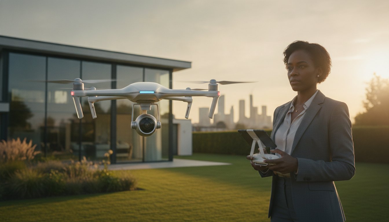
Did you know that property listings featuring professional aerial cinematography sell approximately 68% faster than those relying solely on traditional ground-level photography? In the 2026 real estate market, using drone footage to sell property faster has transitioned from a high-end luxury to a technical necessity for any serious listing. You likely understand the frustration when a premium property sits on the market because static images fail to convey its true scale or its relationship with the surrounding landscape. It is a common challenge for agents who know a home’s value but struggle to demonstrate its context to remote or discerning buyers.
We believe that high-quality visual data is the key to building immediate trust with potential leads. This guide will show you how professional aerial cinematography and technical precision can eliminate buyer uncertainty and drive deep emotional engagement. You’ll learn the specific visual techniques that increase lead quality and how to maintain strict safety and privacy standards while standing out on portals like Rightmove and Zoopla. From FAA compliance to post-production excellence, we provide the expert roadmap you need to accelerate your transaction times and ensure your properties receive the attention they deserve.
Key Takeaways
- Learn how to leverage the ‘Thumb-Stop’ effect on major portals like Rightmove and Zoopla to capture buyer attention immediately.
- Understand how a ‘Spatial Narrative’ provides the geographical context and structural transparency required to build immediate buyer trust.
- Discover a proven five-step strategy for using drone footage to sell property faster by optimising your visual assets for maximum online exposure.
- Identify the specific scenarios where a listing requires technical drone survey data instead of standard cinematic marketing footage.
- Verify the critical legal requirements, including CAA GVC certification and professional liability insurance, to ensure your property marketing remains fully compliant.
The Impact of Aerial Visuals on Real Estate Sales Velocity
Sales velocity represents the specific duration between a property listing going live and the acceptance of a formal offer. In the competitive UK market, particularly on platforms like Rightmove and Zoopla, listings that fail to capture interest within the first 14 days often face the risk of stagnation. Using drone footage to sell property faster addresses this by creating an immediate ‘Thumb-Stop’ effect. When a potential buyer scrolls through hundreds of similar street-level photos, a high-altitude thumbnail provides instant visual variety. This perspective signals a premium listing and encourages a significantly higher click-through rate compared to traditional photography.
This visual engagement is backed by professional market data. Statistics from early 2026 indicate that listings featuring aerial components sell 68% faster than those relying solely on ground-based imagery. This isn’t just because the visuals are aesthetically pleasing; it’s because they deliver a higher volume of geographic information in a shorter timeframe. Buyers can immediately assess the property’s relationship with its environment, which is a critical factor in the digital-first viewing process. If you are interested in how these standards apply to the rental sector, you can discover KASA Tech for high-quality residential properties across the UK.
To better understand how these visuals transform the selling process, watch this short analysis of drone impact on sales speed:
The 2026 Buyer: Why Digital Transparency Wins
Modern buyers are research-driven and demand a high level of digital transparency before committing to a physical visit. They use aerial perspectives to perform their own due diligence on the surrounding area, checking for property boundaries, garden scale, and proximity to local infrastructure. While the history of aerial photography shows a transition from niche surveillance to accessible cinematography, the core value remains grounded in providing context. 4K HDR footage provides a truthful representation of the land, which builds early rapport and trust. By providing this information upfront, agents effectively reduce ‘wasted’ physical viewings from buyers who might have otherwise been deterred by the local geography only after arriving on-site.
Quantifying the ROI of Professional Drone Filming
The financial benefits of professional filming extend beyond just a quick transaction. Properties marketed with comprehensive aerial data often attract higher initial offers because the perceived value of the listing is elevated through high-end production. For property developers, using drone footage to sell property faster also creates a permanent marketing asset that can be repurposed for future phases or brand-building exercises. It’s a meticulous approach to data-centric marketing that prioritises buyer psychological comfort. For estate agencies, the return on investment is defined as the total cost of professional aerial services weighed against the cumulative value of reduced marketing duration and the higher conversion rate of digital leads into successful completions.
Beyond the Bird’s-Eye View: How Drone Footage Builds Buyer Trust
While the initial appeal of aerial imagery is often aesthetic, its true commercial value lies in providing the objective context required to build buyer trust. In 2026, sophisticated buyers look past the “wow factor” and seek out a “Spatial Narrative” that connects a property to its broader environment. This narrative bridges the gap between a floor plan and a physical visit, allowing potential leads to visualise how a home functions within its specific geography. By using drone footage to sell property faster, you’re not just providing a view; you’re providing structural and environmental transparency that traditional photography cannot replicate.
This approach moves the conversation from “pretty shots” to “informative data.” A well-executed flight path demonstrates the property’s relationship with its neighbours, the ease of access to the driveway, and the true scale of the surrounding land. It’s about providing a comprehensive visual record that answers a buyer’s unspoken questions before they even step onto the premises.
Neighbourhood Context: The Invisible Selling Point
Aerial cinematography excels at showcasing the intangible benefits of a location. A standard map indicates proximity to local infrastructure, but a drone flight demonstrates the reality of a quiet cul-de-sac or the true accessibility of nearby transport links. It effectively captures the scenic vistas and green spaces that define a property’s character. Even international industry benchmarks, such as the National Association of REALTORS® drone guidance, highlight how this level of environmental detail is a significant factor in converting passive browsers into active leads. It creates a sense of place that static photos miss, ensuring that by the time a buyer requests a viewing, they’re already convinced by the neighbourhood’s suitability.
Structural Integrity and Scale Appreciation
From a technical perspective, drones allow for the inspection of features that are usually invisible from the ground. High-resolution sensors can capture the condition of chimney stacks, leadwork, and complex roof valleys, providing a level of reassurance that’s particularly valuable for older UK estates. For modern homes, it’s the most efficient way to showcase high-value additions like solar arrays or extensive outbuildings.
Aerial perspectives also resolve common buyer objections regarding external space. Professional cinematography allows viewers to appreciate the flow of a garden and its orientation relative to the sun throughout the day. By providing a clear, top-down perspective of property boundaries, drones eliminate the “is the garden big enough?” objection before it can even be raised. Adopting a methodical approach to using drone footage to sell property faster ensures that every technical aspect of the land is visible to the buyer from the outset. If you’re looking to enhance your listing’s transparency, our aerial filming and photography services provide the technical precision required to secure buyer confidence.
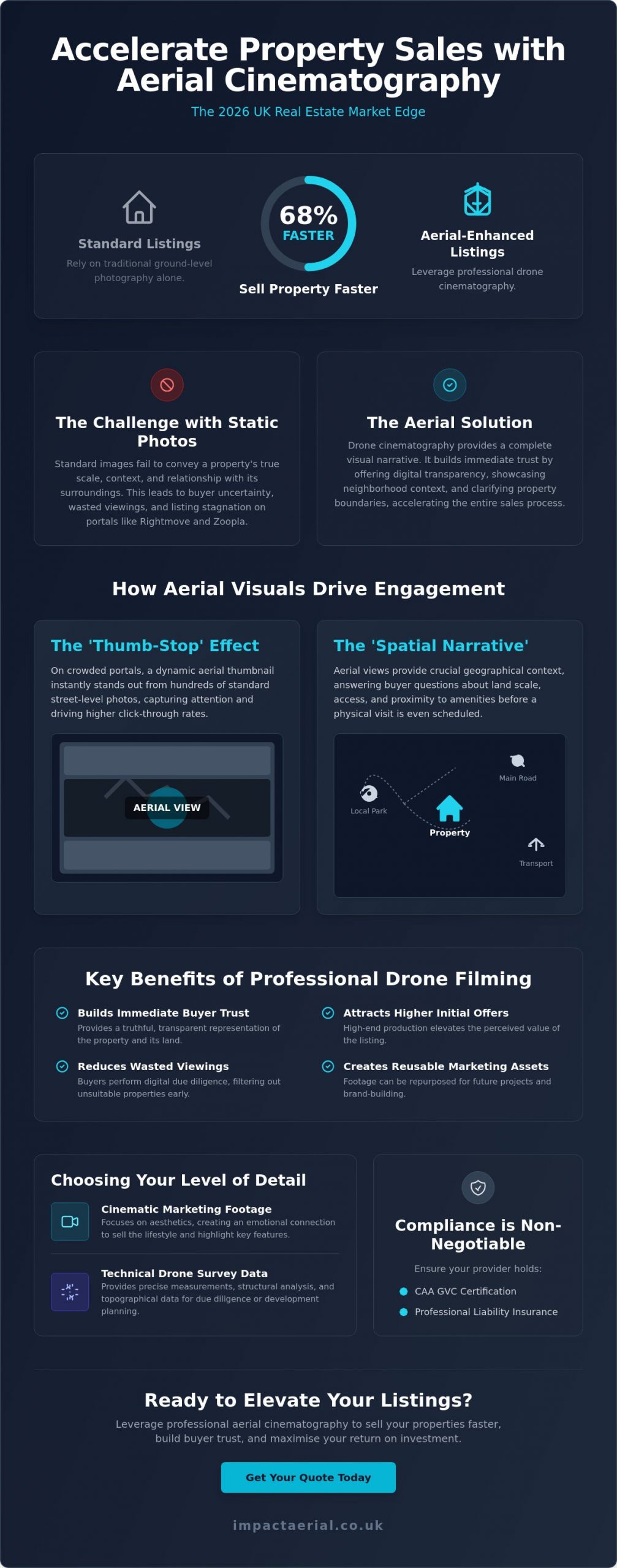
Professional Drone Surveys vs. Marketing Footage: Choosing Your Level of Detail
Identifying the specific type of aerial data required for a listing is essential for an efficient marketing strategy. While previous sections highlighted the emotional impact of a spatial narrative, this stage focuses on the technical distinction between cinematic “marketing” footage and empirical “survey” data. Both are vital tools for using drone footage to sell property faster, but they serve different phases of the buyer’s journey. Marketing footage captures the lifestyle and aesthetic appeal of a home; technical surveys provide the structural evidence required to close high-value transactions without delay.
Professional standards remain the baseline for any aerial operation. While international regulatory frameworks like the FAA rules for commercial drone operators set a global benchmark for safety and pilot certification, UK-based agencies must ensure their operators hold the specific CAA GVC credentials required for domestic commercial work. Using DJI Enterprise hardware ensures that the raw data captured, whether for a survey or a film, possesses the 4K HDR depth necessary for high-end post-production. This meticulous editing process ensures every property is market-ready, presenting a polished and trustworthy image to potential investors.
Cinematic Storytelling for Luxury Listings
For premium residential properties, the objective is to create a seamless visual flow that ground-based cameras cannot achieve. This involves the use of smooth gimbal movements and slow-motion pans to highlight architectural elegance. A professional aerial filming drone allows for the integration of high-altitude perspectives with intimate, low-level tracking shots. Post-production colour grading further enhances this visual appeal, ensuring that the property’s exterior and grounds are represented with vibrant, aspirational clarity that captures the buyer’s imagination immediately.
Technical Surveys for High-Value Transactions
When a property involves complex structures or extensive commercial acreage, a technical drone survey provides a layer of due diligence that cinematic footage lacks. These surveys produce detailed roof reports and high-resolution orthomosaic maps, offering pre-purchase peace of mind regarding the building’s condition. For eco-conscious developments, thermal imaging sensors can even verify insulation quality or the efficiency of solar installations. Using drone footage to sell property faster in these scenarios involves providing “Aerial Evidence” that justifies a premium asking price and removes structural uncertainty during the final stages of a sale.
Strategic Implementation: Maximising Exposure Across Property Portals
Generating high-quality aerial cinematography is only the first stage of a successful marketing campaign. To see a genuine return on investment, you must deploy these assets strategically across multiple digital channels. Using drone footage to sell property faster requires a methodical approach to distribution, ensuring that each platform receives content tailored to its specific audience and technical requirements. A fragmented or unplanned upload strategy often results in diminished engagement and missed opportunities with high-value leads.
We recommend a structured 5-step deployment plan to ensure maximum impact:
- Technical Acquisition: Capture high-resolution 4K footage using professional-grade sensors.
- Meticulous Post-Production: Apply colour grading and professional editing to create a polished, market-ready narrative.
- Portal Optimisation: Upload tailored video files to Rightmove, Zoopla, and OnTheMarket to capture ‘Thumb-Stop’ interest.
- Social Syndication: Distribute high-impact ‘Teaser’ clips across Instagram, TikTok, and Facebook.
- Immersive Integration: Combine aerial views with virtual tour creation to provide a comprehensive digital viewing experience.
Optimising for the Big Three: Rightmove, Zoopla, and Socials
Property portals have specific technical preferences that dictate how your content performs. For the “Big Three” platforms, a 16:9 aspect ratio remains the standard for gallery videos. It’s essential to keep these edits concise, typically under 90 seconds, to maintain viewer retention. Using a high-altitude drone still as your primary ‘hook’ thumbnail can significantly increase click-through rates from search results. This strategy leverages the visual variety of an aerial perspective to increase ‘time on page’, a metric that signals high engagement to portal algorithms and keeps your listing at the forefront of buyer searches.
The Power of the ‘First Look’ Social Campaign
Social media platforms require a different creative approach. Vertical 9:16 video clips, often referred to as ‘Teasers’, are highly effective for Instagram Reels and TikTok. These 15-second high-impact segments focus on the property’s most aspirational features, such as a sprawling garden or a unique architectural profile. This method is particularly successful at driving traffic from Facebook advertising directly to the full listing. It’s a vital tool for engaging out-of-area buyers who rely heavily on digital content to shortlist properties before committing to a long-distance journey. By using drone footage to sell property faster through social syndication, you reach a broader demographic of active searchers.
Implementing these technical strategies ensures your property stands out in a crowded digital marketplace. If you’re ready to elevate your marketing with precision-engineered visuals, our aerial filming and photography services provide the high-end output your listings require.
Why Compliance and Quality are Non-Negotiable for Property Marketing
While the visual and strategic advantages of aerial cinematography are significant, the operational foundation of these services must rest on strict regulatory compliance. In the United Kingdom, any drone operation conducted for commercial gain requires a pilot with a valid General Visual Line of Sight Certificate (GVC) issued by the Civil Aviation Authority (CAA). This is not a voluntary standard; it is a legal mandate that ensures the safety of the public and the integrity of the property industry. Using drone footage to sell property faster is an effective strategy, but it must be executed within this professional framework to protect all parties involved in the transaction.
Professional drone operators function as risk-managed consultancies rather than simple creative agencies. This distinction is most evident in the requirement for comprehensive commercial liability insurance, which should ideally be set at a minimum of £5 million for estate agency work. This level of coverage provides essential reassurance to both the agency and the homeowner, ensuring that any unforeseen incidents are fully covered. Relying on uncertified or uninsured operators introduces a level of risk that can lead to catastrophic reputational damage and severe financial penalties, particularly when operating in densely populated residential areas.
The Dangers of DIY and Unlicensed Pilots
The rise of consumer drone technology has led to an increase in unauthorized aerial filming, which poses significant privacy and GDPR risks for property professionals. Unlicensed pilots often lack the technical training to navigate complex UK privacy laws, which can result in the accidental filming of neighbouring properties and subsequent legal complaints. The CAA has the authority to issue heavy fines for non-compliant flights, and the resulting legal action can permanently tarnish an agency’s professional standing. It’s critical to verify a pilot’s drone license and insurance status before every shoot to ensure the operation is fully compliant with 2026 aviation standards. This meticulous vetting process is a vital component of using drone footage to sell property faster while maintaining ethical boundaries.
Impact Aerial: Your Partner in Professional Property Marketing
At Impact Aerial, we maintain a commitment to safety-first operations and technical precision that goes beyond basic compliance. We treat every property shoot as a professional consultancy, providing a seamless service from the initial risk assessment to the final cinematic edit. Our investment in a DJI Enterprise fleet ensures that we deliver consistent, high-tier output that meets the demanding standards of the 2026 luxury market. By positioning our drone services as a trusted extension of your marketing team, we provide the psychological comfort and tangible results required to accelerate your sales velocity. We’re proud of our professional affiliations and technical credentials, which serve as a guarantee that your property marketing is managed by experts who take the operational side of the business as seriously as the visual output.
Elevating Your Property Strategy for 2026
We’ve explored how high-resolution aerial cinematography transforms property listings from static images into immersive spatial narratives. By providing clear geographic context and structural transparency, you eliminate buyer hesitation and significantly increase sales velocity. A professional approach ensures that every flight is backed by meticulous technical standards and strict regulatory adherence. Integrating these advanced visual tools is the most effective method for using drone footage to sell property faster in a competitive digital market. It’s about more than just a view; it’s about providing the verified data and emotional engagement that modern buyers demand.
Ready to transform your listings with industry-leading quality? Book a professional drone shoot to accelerate your property sales and benefit from our CAA GVC Certified Pilots, £5m commercial liability insurance, and 4K HDR cinematic production. Your properties deserve a perspective that captures their full potential and secures the confidence of high-value buyers. We look forward to helping you stand out on the UK’s leading property portals with precision and excellence.
Frequently Asked Questions
Does drone footage actually increase the final sale price of a property?
High-quality aerial visuals elevate the perceived value of a listing, which often leads to more competitive bidding. While it doesn’t change the bricks-and-mortar valuation, it highlights premium features like land scale and location that ground-level photos miss. This increased engagement can result in a higher final sale price as buyers perceive the property as a premium offering compared to standard listings in the same area.
Is it legal to fly a drone over a residential neighborhood for property photos?
It’s perfectly legal if the operator holds a valid CAA GVC certification and adheres to the Open or Specific category flight rules. Professional pilots conduct thorough risk assessments to ensure flights don’t endanger the public or breach privacy laws. Using drone footage to sell property faster is a regulated activity that requires strict adherence to national aviation standards to remain compliant, insured, and safe for all residents.
How much does professional drone photography cost for a single property?
Professional service fees depend on several factors, including the property’s size, its location, and the specific deliverables required, such as 4K video or high-resolution stills. While basic packages are available for smaller residential homes, complex estates or commercial sites requiring technical surveys involve different operational requirements. We recommend requesting a bespoke quote to ensure the service matches your specific marketing objectives and technical needs for the listing.
Do I need to notify the neighbors before a drone shoot takes place?
Notifying neighbors is a professional courtesy that prevents privacy concerns and ensures a smooth operation on the day. We suggest informing adjacent residents about the scheduled time and the specific purpose of the flight. This transparency helps mitigate anxiety and demonstrates that the estate agency and the drone operator are committed to ethical and respectful filming practices within the local community.
How long does a typical drone property filming session take?
A standard residential shoot typically takes between 60 and 90 minutes on-site, depending on the number of flight paths required. This timeframe allows the pilot to capture a variety of angles, heights, and cinematic movements. Larger estates or commercial properties may require a half-day or full-day session to ensure every technical detail, including property boundaries and outbuildings, is documented with the necessary precision and clarity.
Can drone footage be used for commercial property and land sales too?
Aerial data is invaluable for commercial listings where ground-level photos can’t capture the true scale of a warehouse or the layout of an industrial park. It allows investors to assess vehicle access, parking capacity, and proximity to transport hubs. Using drone footage to sell property faster is particularly effective for land sales, as it provides a clear, top-down perspective of boundaries and topography that investors require for due diligence.
What happens if the weather is bad on the day of the scheduled drone shoot?
Safety is our primary concern, so we don’t operate in high winds or heavy rain. If the forecast suggests conditions that would compromise the drone’s stability or the visual quality of the 4K HDR footage, we’ll coordinate a new date. This ensures the final output meets our professional standards and that the property is presented in the best possible light under clear skies for maximum buyer appeal.
How do I add drone video to my Rightmove or Zoopla listing?
You can easily add aerial video by uploading the file to a hosting platform like YouTube or Vimeo and then adding the link to the property’s media gallery on the portal. Most UK platforms have a dedicated ‘Video’ tab that displays the content prominently to potential buyers. This integration ensures that the ‘Thumb-Stop’ effect is maximized, encouraging potential buyers to engage with the listing for longer periods during their search.
