
How to Use Drone Survey Data Effectively: A Professional Guide

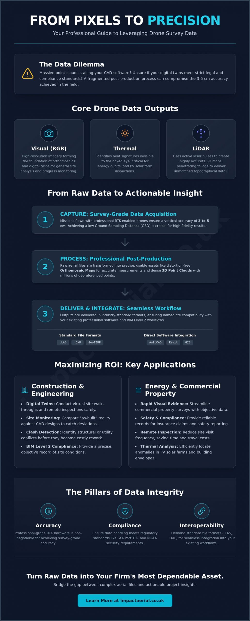
While drone mapping can achieve a vertical accuracy of 3 to 5 cm with proper RTK technology, that precision is often lost during a fragmented post-production process. You’ve likely experienced the frustration of handling massive point clouds or orthomosaics that stall your existing CAD or BIM software. It’s a common challenge to feel overwhelmed by file sizes or uncertain about whether your digital twins meet the strict legal standards required for high-stakes construction and energy projects.

This professional guide explains how to use drone survey data effectively to transform raw aerial captures into precise, actionable insights. You’ll learn how to integrate these digital assets seamlessly into AutoCAD or Revit to reduce site visit frequency and improve safety reporting with objective visual evidence. We’ll also cover the technical requirements for maintaining compliance with 2026 FAA Part 107 rules and NDAA security standards, ensuring your data is as reliable as it is detailed. By the end of this guide, you’ll have a clear roadmap for turning complex aerial data into a dependable asset for your firm’s decision-making framework.

Key Takeaways

  • Master the distinction between RGB, thermal, and LiDAR outputs to ensure your aerial data aligns with your specific engineering or inspection requirements.
  • Discover how to use drone survey data effectively by mastering the export of .DXF and .LAS files for seamless integration into professional CAD and BIM Level 2 workflows.
  • Maximise ROI by implementing digital twins for construction site monitoring and rapid, objective visual evidence in commercial property surveys.
  • Ensure data integrity and regulatory compliance by understanding why professional-grade hardware and RTK positioning are essential for survey-grade accuracy.
  • Streamline your decision-making process with a clear implementation roadmap that bridges the gap between raw aerial files and actionable project insights.

What is Drone Survey Data? Understanding the Core Outputs

Drone survey data isn’t simply a collection of aerial photographs. It’s a precise, georeferenced digital representation of a physical asset or landscape. To understand how to use drone survey data effectively, you must first distinguish between the three primary sensor outputs: visual (RGB), thermal, and LiDAR. RGB sensors provide the high-resolution imagery needed for general site analysis, whereas thermal sensors identify heat signatures during PV solar farm thermal surveys. LiDAR is distinct because it uses active laser pulses to map terrain even through dense foliage, providing a level of topographical detail that traditional cameras can’t match.

Raw data captured during a flight is essentially a massive collection of unstructured files. It’s through professional unmanned aerial photogrammetric survey techniques and dedicated post-production services that these files become useful. A critical metric in this process is Ground Sampling Distance (GSD). GSD represents the actual distance on the ground between the centers of two consecutive pixels. If your GSD is 2 cm, each pixel in your map represents 2 cm of real-world space. Achieving a low GSD is essential for the high-tier quality required in professional engineering and property surveys.

To visualize how these technical components come together during a professional mission, watch this deep dive:

Orthomosaic Mapping: The Foundation of Site Analysis

Orthomosaics are the foundation of modern site analysis. This process involves stitching together hundreds of overlapping aerial images into a single, distortion-free map. Unlike a standard photograph, an orthomosaic is geometrically corrected for camera tilt and topographic relief. This allows project managers to perform centimetre-accurate distance and area measurements directly from their screens. These maps are invaluable for construction site monitoring, as they provide a clear historical record of site progress. They allow for rapid, objective comparisons against original design plans to catch errors before they become costly.

3D Point Clouds and Digital Twins

When aerial data is processed, it creates a 3D point cloud. This is a collection of millions of individual data points, each assigned an X, Y, and Z coordinate. These point clouds can be converted into textured 3D meshes to create immersive digital twins. Using digital twins allows stakeholders to conduct virtual site walk-throughs and remote inspections without the safety risks or travel costs associated with physical visits. It’s a meticulous way to document a property’s condition, providing a reliable record for insurance and compliance purposes.

Integrating Data into Professional Workflows (CAD, BIM, and GIS)

Capturing high-resolution aerial imagery is only the first step in a professional survey. The true value of these digital assets is realized when they are integrated into your existing technical workflows. To understand how to use drone survey data effectively, you must prioritize interoperability. Professional surveyors deliver georeferenced data in industry-standard formats such as .DXF for vector files, .LAS for point clouds, and GeoTIFFs for orthomosaics. These formats ensure that your aerial captures are immediately compatible with the software your team uses every day.

In the UK, drone data is a vital component of BIM Level 2 compliance. By providing a precise “as-built” record, aerial surveys allow project managers to overlay current site conditions directly against original design CAD files. This objective comparison identifies structural deviations or utility clashes early, preventing the expensive rework that often delays large-scale construction and energy projects. This digital bridge also streamlines collaboration, allowing remote stakeholders to review site progress within a Common Data Environment (CDE) without needing to be physically present. If your team requires assistance with these complex deliverables, our post-production services ensure your raw data is refined into CAD-ready assets.

Using Drone Data in AutoCAD and Revit

For Scan-to-BIM projects, importing 3D point clouds into Revit allows architects to build models based on reality rather than outdated paper plans. This workflow eliminates the manual measurement errors that often occur with traditional ground-based methods. Engineers can also generate precise topographic contours from aerial data to inform site planning or use high-resolution overlays to verify the placement of structural steel and foundations. It’s a meticulous approach that ensures every element of the build aligns with the digital blueprint.

GIS Integration for Large-Scale Land Management

For environmental analysis and estate management, importing orthomosaics into ArcGIS or QGIS provides a level of detail that satellite imagery cannot match. You can combine drone-captured layers with existing Ordnance Survey maps to gain a comprehensive perspective of land assets. By managing multi-temporal data sets, organizations can track land changes over months or years. This is particularly effective for monitoring coastal erosion, managing large-scale vegetation, or documenting the impact of infrastructure developments on the surrounding environment.
How to Use Drone Survey Data Effectively: A Professional Guide

Industry-Specific Applications: Maximising ROI in Construction and Energy

Understanding how to use drone survey data effectively involves moving beyond the digital map and into the balance sheet. For high-stakes industries, the return on investment isn’t just found in the speed of data collection, it’s found in the mitigation of risk and the prevention of project delays. By applying aerial insights to specific operational challenges, firms can transform a technical output into a significant cost-saving tool. Whether you are managing a multi-million pound infrastructure project or a sprawling energy estate, the goal is to replace manual, high-risk inspections with objective, repeatable data.

In the commercial property sector, rapid roof assessments have become a primary application. Traditional scaffolding or cherry picker access can take days to coordinate and execute, often with significant health and safety implications. A professional drone survey captures high-resolution imagery of entire roofing systems in a fraction of the time, allowing surveyors to identify defects, standing water, or structural compromises from the safety of the ground. This speed allows for more frequent inspections, ensuring that minor issues don’t escalate into major structural failures.

Construction Site Monitoring and Safety

Weekly drone flights provide a comprehensive visual record that ground-based photography simply cannot match. Project managers use these captures to identify potential health and safety hazards remotely, such as improper material storage or unsecured perimeters. Beyond safety, aerial data provides a reliable way to calculate stockpile volumes. By using 3D point clouds, software can determine the volume of earth or materials in seconds, a task that would take a manual survey team hours to complete. For a deeper look at these processes, see our guide on construction site monitoring to see how these workflows improve site transparency.

PV Solar Farm Thermal Surveys

For energy providers, the effectiveness of drone data is most apparent in thermal inspections. Solar farms often suffer from “hot spots” or defective cells that are completely invisible to the naked eye but significantly reduce power yield. By using radiometric thermal sensors, we identify these anomalies with precision. The real value comes from integrating this thermal data directly into your maintenance schedules. Instead of checking every panel, your team can go directly to the defective units identified in the survey. This targeted maintenance prevents power loss and quantifies the ROI through improved energy output and reduced technician hours.

Ensuring Data Integrity: Accuracy, Compliance, and Insurance

Data is only as valuable as its reliability. To understand how to use drone survey data effectively, you must first ensure that the foundation of your digital twin is technically sound and legally defensible. Many firms ask if they can simply use internal consumer drones for site mapping. While a hobbyist drone might capture a clear image, it lacks the Real-Time Kinematic (RTK) positioning required for survey-grade results. Standard consumer GPS has a margin of error that can reach several metres, whereas professional DJI Enterprise hardware achieves horizontal accuracy of 2 to 3 cm. This precision is the difference between a visual reference and a tool that can be used for high-stakes engineering decisions.

The legal weight of your data is equally important. In 2026, mandatory Remote ID systems and stricter data security protocols mean that commercial operations must be meticulously documented. Data captured by a non-certified pilot often lacks the necessary metadata and safety logs to stand up in a legal or insurance dispute. By using a CAA-certified pilot, you ensure that every flight follows a structured risk assessment process, providing you with objective visual evidence that carries professional authority. If you are ready to implement these standards on your next project, you can request a compliance-led survey from our expert team.

Why CAA GVC Certification Matters for Your Data

The General Visual Line of Sight Certificate (GVC) is more than just a permit to fly; it’s a guarantee of operational safety. This certification ensures that pilots have undergone rigorous training in airspace management and emergency protocols, which is vital when operating in congested areas or near critical infrastructure. Certified operations significantly mitigate risk for the client, ensuring that data collection doesn’t compromise site safety. For a detailed breakdown of these regulations, refer to our UK drone license guide to understand how these rules protect your project’s integrity.

Professional Liability and Data Security

High-value sites require more than just technical skill; they require financial protection. We maintain £5m commercial liability insurance, which is a fundamental prerequisite for any professional drone survey in 2026. This coverage provides peace of mind for stakeholders, ensuring that any unforeseen incidents are fully covered under a commercial policy. Beyond physical safety, we implement strict data handling protocols. Your survey data is stored on secure servers and delivered via protected links to prevent unauthorized access. Professional insurance and robust cybersecurity are no longer optional extras; they are the baseline for trustworthy commercial drone operations.

From Raw Files to Decisions: Your Implementation Roadmap

Transitioning from a successful flight to a data-driven decision requires a structured approach. Learning how to use drone survey data effectively is not just about the technology; it’s about the workflow that follows the capture. To ensure your project benefits from the high-tier precision of aerial data, follow this five-step implementation roadmap.

  • Step 1: Define clear project objectives. Before the drone even leaves the ground, you must determine if you require survey-grade accuracy (RTK-driven) for engineering or high-resolution visual detail for property inspections. Defining these goals early prevents the collection of redundant data.
  • Step 2: Choose the right output format. Ensure your internal software, whether it’s Revit, AutoCAD, or ArcGIS, is compatible with the deliverables. Requesting .DXF for vectors or .LAS for point clouds ensures a seamless transition into your existing technical environment.
  • Step 3: Establish a collection cadence. Data is most valuable when it’s used for comparison. Establish a routine, such as weekly flights for construction site monitoring or biannual checks for solar farm health, to track changes over time.
  • Step 4: Distribute insights via cloud platforms. Massive file sizes can hinder collaboration. Use cloud-based viewers to share digital twins and orthomosaics with remote stakeholders, allowing them to measure and annotate data without specialized hardware.
  • Step 5: Partner with a specialist for analysis. Raw data is a liability if it isn’t processed correctly. Partnering with a professional for post-production services ensures that your outputs are accurate, compliant, and ready for immediate use.

Consultation and Project Planning

At Impact Aerial, we work closely with our clients to define the most efficient data capture strategy for their specific needs. Our meticulous pre-flight planning involves identifying site constraints, managing airspace permissions, and ensuring every mission adheres to the strictest safety protocols. We don’t just deliver files; we provide a customized deliverable that aligns with your industry requirements. This structured consultation phase ensures that the final data is a reliable asset rather than a technical burden for your team.

Ready to Elevate Your Project Data?

Professional drone services provide UK businesses with an objective, high-resolution perspective that traditional methods simply cannot match. From reducing site visit frequency to improving the accuracy of safety reporting, the benefits of digital twins are clear. Based in Birmingham, we provide nationwide coverage, bringing technical expertise and CAA-certified reliability to projects across the country. If you are ready to transform your site operations with high-tier aerial insights, contact us today to request a bespoke survey quote and discover how our professional standards can support your project goals.

Advancing Your Digital Site Strategy

The transition from raw aerial files to high-tier project intelligence requires a meticulous approach to software integration and regulatory compliance. You’ve seen that the true value of these digital assets lies in their ability to merge with existing CAD and BIM workflows, providing a reliable as-built record that reduces site visits and costly rework. Understanding how to use drone survey data effectively is ultimately about bridging the gap between sophisticated hardware and your firm’s decision-making framework. For teams looking to scale these digital insights through automation, you can learn more about Business With AI Strategist to discover strategic implementation services.

By prioritizing survey-grade accuracy and professional-grade outputs, you ensure that every digital twin is a defensible asset for your business. We provide the technical expertise needed to secure these results, supported by CAA GVC Certified Pilots and the latest DJI Enterprise Grade Hardware. Our operations are backed by £5m Commercial Liability Insurance, offering the reassurance and reliability required for complex infrastructure and energy projects.

If you’re ready to modernize your data collection process, request a professional drone survey quote from Impact Aerial today. We look forward to helping you transform your aerial perspectives into tangible project success.

Frequently Asked Questions

How accurate is drone survey data compared to traditional methods?

Drone surveys achieve horizontal accuracy of 2 to 3 cm and vertical accuracy of 3 to 5 cm when using RTK or PPK technology. This level of precision is comparable to traditional ground-based surveying for most construction and property applications. While traditional methods are meticulous for individual points, drones provide a much higher data density by capturing millions of points across the entire site in a fraction of the time.

What software do I need to view drone survey point clouds?

To view and manipulate 3D point clouds, you typically need professional CAD or BIM software such as Autodesk Revit, AutoCAD, or Civil 3D. For large-scale land management and environmental analysis, GIS platforms like ArcGIS or QGIS are the industry standard. These tools allow you to integrate aerial data into your existing technical workflows for precise measurements and structural analysis.

Can drone survey data be used for legal property boundary disputes?

Drone data provides objective visual evidence of physical encroachments and site conditions that can support legal cases. However, it must be captured by a CAA-certified pilot to ensure the metadata and safety logs are defensible. While it doesn’t replace official title deeds, it serves as a powerful supplement to a licensed surveyor’s report by providing an undeniable visual record of the land at a specific date.

How long does it take to process drone survey data after the flight?

A typical 50-acre drone survey can be completed, from flight to final deliverable, in approximately 4 to 8 hours. This rapid turnaround is a key reason why project managers prioritize how to use drone survey data effectively for tight construction schedules. More complex datasets, such as high-density LiDAR or multi-temporal thermal analysis, may require additional processing time in post-production to ensure high-tier quality.

What is the difference between LiDAR and Photogrammetry in drone surveys?

LiDAR uses active laser pulses to map the terrain and can penetrate dense vegetation to reach the ground surface. Photogrammetry relies on overlapping high-resolution images to reconstruct a 3D model through triangulation. While photogrammetry is excellent for visual site mapping and progress monitoring, LiDAR is the professional choice for topographical surveys in wooded areas or for mapping thin infrastructure like power lines.

Is a drone survey cheaper than a traditional land survey?

Drone surveys are frequently 50% to 75% less expensive than traditional ground-based surveys for large sites. This cost efficiency is driven by the significant reduction in field hours and the ability to cover vast areas without a large team of surveyors. By choosing aerial methods, firms can allocate their budgets more effectively while receiving a more comprehensive digital representation of their physical assets.

What weather conditions prevent a drone survey from being accurate?

High winds, heavy rain, and low-light conditions are the primary factors that compromise data integrity. Excessive wind can cause motion blur in photogrammetry, while rain interferes with laser sensors and camera lenses. Meticulous pilots monitor weather windows to ensure that every flight is conducted within the safe operational limits of their DJI Enterprise hardware, ensuring the final output meets professional standards.

Do I need to be on-site during the drone survey?

You don’t need to be physically present during the drone operation as long as the pilot has site access and a clear project brief. The captured data is processed and delivered via secure digital links, allowing you to review site conditions from any location. This remote capability is a major benefit for stakeholders managing multiple projects across the country, as it eliminates the need for frequent travel.
Using Drone Footage to Sell Property Faster: The Professional Guide for 2026

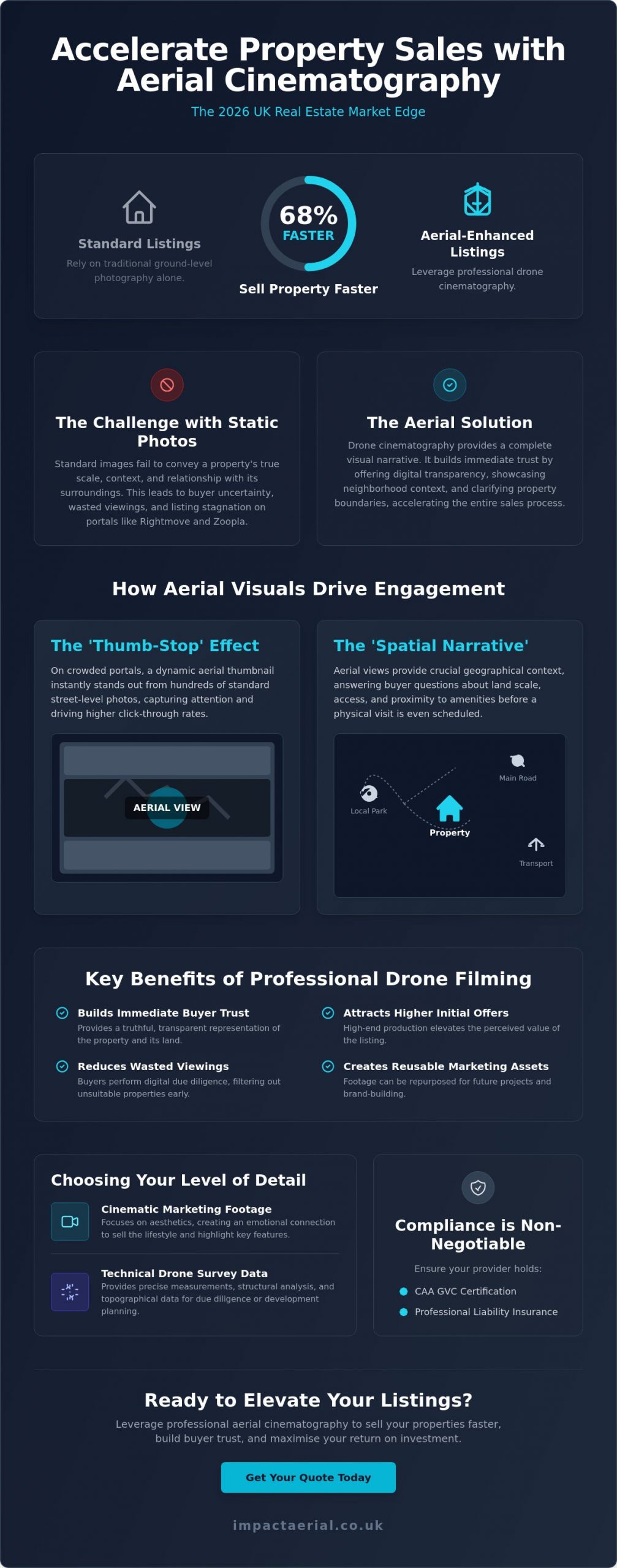
Did you know that property listings featuring professional aerial cinematography sell approximately 68% faster than those relying solely on traditional ground-level photography? In the 2026 real estate market, using drone footage to sell property faster has transitioned from a high-end luxury to a technical necessity for any serious listing. You likely understand the frustration when a premium property sits on the market because static images fail to convey its true scale or its relationship with the surrounding landscape. It is a common challenge for agents who know a home’s value but struggle to demonstrate its context to remote or discerning buyers.

We believe that high-quality visual data is the key to building immediate trust with potential leads. This guide will show you how professional aerial cinematography and technical precision can eliminate buyer uncertainty and drive deep emotional engagement. You’ll learn the specific visual techniques that increase lead quality and how to maintain strict safety and privacy standards while standing out on portals like Rightmove and Zoopla. From FAA compliance to post-production excellence, we provide the expert roadmap you need to accelerate your transaction times and ensure your properties receive the attention they deserve.

Key Takeaways

  • Learn how to leverage the ‘Thumb-Stop’ effect on major portals like Rightmove and Zoopla to capture buyer attention immediately.
  • Understand how a ‘Spatial Narrative’ provides the geographical context and structural transparency required to build immediate buyer trust.
  • Discover a proven five-step strategy for using drone footage to sell property faster by optimising your visual assets for maximum online exposure.
  • Identify the specific scenarios where a listing requires technical drone survey data instead of standard cinematic marketing footage.
  • Verify the critical legal requirements, including CAA GVC certification and professional liability insurance, to ensure your property marketing remains fully compliant.

The Impact of Aerial Visuals on Real Estate Sales Velocity

Sales velocity represents the specific duration between a property listing going live and the acceptance of a formal offer. In the competitive UK market, particularly on platforms like Rightmove and Zoopla, listings that fail to capture interest within the first 14 days often face the risk of stagnation. Using drone footage to sell property faster addresses this by creating an immediate ‘Thumb-Stop’ effect. When a potential buyer scrolls through hundreds of similar street-level photos, a high-altitude thumbnail provides instant visual variety. This perspective signals a premium listing and encourages a significantly higher click-through rate compared to traditional photography.

This visual engagement is backed by professional market data. Statistics from early 2026 indicate that listings featuring aerial components sell 68% faster than those relying solely on ground-based imagery. This isn’t just because the visuals are aesthetically pleasing; it’s because they deliver a higher volume of geographic information in a shorter timeframe. Buyers can immediately assess the property’s relationship with its environment, which is a critical factor in the digital-first viewing process. If you are interested in how these standards apply to the rental sector, you can discover KASA Tech for high-quality residential properties across the UK.

To better understand how these visuals transform the selling process, watch this short analysis of drone impact on sales speed:

The 2026 Buyer: Why Digital Transparency Wins

Modern buyers are research-driven and demand a high level of digital transparency before committing to a physical visit. They use aerial perspectives to perform their own due diligence on the surrounding area, checking for property boundaries, garden scale, and proximity to local infrastructure. While the history of aerial photography shows a transition from niche surveillance to accessible cinematography, the core value remains grounded in providing context. 4K HDR footage provides a truthful representation of the land, which builds early rapport and trust. By providing this information upfront, agents effectively reduce ‘wasted’ physical viewings from buyers who might have otherwise been deterred by the local geography only after arriving on-site.

Quantifying the ROI of Professional Drone Filming

The financial benefits of professional filming extend beyond just a quick transaction. Properties marketed with comprehensive aerial data often attract higher initial offers because the perceived value of the listing is elevated through high-end production. For property developers, using drone footage to sell property faster also creates a permanent marketing asset that can be repurposed for future phases or brand-building exercises. It’s a meticulous approach to data-centric marketing that prioritises buyer psychological comfort. For estate agencies, the return on investment is defined as the total cost of professional aerial services weighed against the cumulative value of reduced marketing duration and the higher conversion rate of digital leads into successful completions.

Beyond the Bird’s-Eye View: How Drone Footage Builds Buyer Trust

While the initial appeal of aerial imagery is often aesthetic, its true commercial value lies in providing the objective context required to build buyer trust. In 2026, sophisticated buyers look past the “wow factor” and seek out a “Spatial Narrative” that connects a property to its broader environment. This narrative bridges the gap between a floor plan and a physical visit, allowing potential leads to visualise how a home functions within its specific geography. By using drone footage to sell property faster, you’re not just providing a view; you’re providing structural and environmental transparency that traditional photography cannot replicate.

This approach moves the conversation from “pretty shots” to “informative data.” A well-executed flight path demonstrates the property’s relationship with its neighbours, the ease of access to the driveway, and the true scale of the surrounding land. It’s about providing a comprehensive visual record that answers a buyer’s unspoken questions before they even step onto the premises.

Neighbourhood Context: The Invisible Selling Point

Aerial cinematography excels at showcasing the intangible benefits of a location. A standard map indicates proximity to local infrastructure, but a drone flight demonstrates the reality of a quiet cul-de-sac or the true accessibility of nearby transport links. It effectively captures the scenic vistas and green spaces that define a property’s character. Even international industry benchmarks, such as the National Association of REALTORS® drone guidance, highlight how this level of environmental detail is a significant factor in converting passive browsers into active leads. It creates a sense of place that static photos miss, ensuring that by the time a buyer requests a viewing, they’re already convinced by the neighbourhood’s suitability.

Structural Integrity and Scale Appreciation

From a technical perspective, drones allow for the inspection of features that are usually invisible from the ground. High-resolution sensors can capture the condition of chimney stacks, leadwork, and complex roof valleys, providing a level of reassurance that’s particularly valuable for older UK estates. For modern homes, it’s the most efficient way to showcase high-value additions like solar arrays or extensive outbuildings.

Aerial perspectives also resolve common buyer objections regarding external space. Professional cinematography allows viewers to appreciate the flow of a garden and its orientation relative to the sun throughout the day. By providing a clear, top-down perspective of property boundaries, drones eliminate the “is the garden big enough?” objection before it can even be raised. Adopting a methodical approach to using drone footage to sell property faster ensures that every technical aspect of the land is visible to the buyer from the outset. If you’re looking to enhance your listing’s transparency, our aerial filming and photography services provide the technical precision required to secure buyer confidence.

Using Drone Footage to Sell Property Faster: The Professional Guide for 2026

Professional Drone Surveys vs. Marketing Footage: Choosing Your Level of Detail

Identifying the specific type of aerial data required for a listing is essential for an efficient marketing strategy. While previous sections highlighted the emotional impact of a spatial narrative, this stage focuses on the technical distinction between cinematic “marketing” footage and empirical “survey” data. Both are vital tools for using drone footage to sell property faster, but they serve different phases of the buyer’s journey. Marketing footage captures the lifestyle and aesthetic appeal of a home; technical surveys provide the structural evidence required to close high-value transactions without delay.

Professional standards remain the baseline for any aerial operation. While international regulatory frameworks like the FAA rules for commercial drone operators set a global benchmark for safety and pilot certification, UK-based agencies must ensure their operators hold the specific CAA GVC credentials required for domestic commercial work. Using DJI Enterprise hardware ensures that the raw data captured, whether for a survey or a film, possesses the 4K HDR depth necessary for high-end post-production. This meticulous editing process ensures every property is market-ready, presenting a polished and trustworthy image to potential investors.

Cinematic Storytelling for Luxury Listings

For premium residential properties, the objective is to create a seamless visual flow that ground-based cameras cannot achieve. This involves the use of smooth gimbal movements and slow-motion pans to highlight architectural elegance. A professional aerial filming drone allows for the integration of high-altitude perspectives with intimate, low-level tracking shots. Post-production colour grading further enhances this visual appeal, ensuring that the property’s exterior and grounds are represented with vibrant, aspirational clarity that captures the buyer’s imagination immediately.

Technical Surveys for High-Value Transactions

When a property involves complex structures or extensive commercial acreage, a technical drone survey provides a layer of due diligence that cinematic footage lacks. These surveys produce detailed roof reports and high-resolution orthomosaic maps, offering pre-purchase peace of mind regarding the building’s condition. For eco-conscious developments, thermal imaging sensors can even verify insulation quality or the efficiency of solar installations. Using drone footage to sell property faster in these scenarios involves providing “Aerial Evidence” that justifies a premium asking price and removes structural uncertainty during the final stages of a sale.

Strategic Implementation: Maximising Exposure Across Property Portals

Generating high-quality aerial cinematography is only the first stage of a successful marketing campaign. To see a genuine return on investment, you must deploy these assets strategically across multiple digital channels. Using drone footage to sell property faster requires a methodical approach to distribution, ensuring that each platform receives content tailored to its specific audience and technical requirements. A fragmented or unplanned upload strategy often results in diminished engagement and missed opportunities with high-value leads.

We recommend a structured 5-step deployment plan to ensure maximum impact:

  • Technical Acquisition: Capture high-resolution 4K footage using professional-grade sensors.
  • Meticulous Post-Production: Apply colour grading and professional editing to create a polished, market-ready narrative.
  • Portal Optimisation: Upload tailored video files to Rightmove, Zoopla, and OnTheMarket to capture ‘Thumb-Stop’ interest.
  • Social Syndication: Distribute high-impact ‘Teaser’ clips across Instagram, TikTok, and Facebook.
  • Immersive Integration: Combine aerial views with virtual tour creation to provide a comprehensive digital viewing experience.

Optimising for the Big Three: Rightmove, Zoopla, and Socials

Property portals have specific technical preferences that dictate how your content performs. For the “Big Three” platforms, a 16:9 aspect ratio remains the standard for gallery videos. It’s essential to keep these edits concise, typically under 90 seconds, to maintain viewer retention. Using a high-altitude drone still as your primary ‘hook’ thumbnail can significantly increase click-through rates from search results. This strategy leverages the visual variety of an aerial perspective to increase ‘time on page’, a metric that signals high engagement to portal algorithms and keeps your listing at the forefront of buyer searches.

The Power of the ‘First Look’ Social Campaign

Social media platforms require a different creative approach. Vertical 9:16 video clips, often referred to as ‘Teasers’, are highly effective for Instagram Reels and TikTok. These 15-second high-impact segments focus on the property’s most aspirational features, such as a sprawling garden or a unique architectural profile. This method is particularly successful at driving traffic from Facebook advertising directly to the full listing. It’s a vital tool for engaging out-of-area buyers who rely heavily on digital content to shortlist properties before committing to a long-distance journey. By using drone footage to sell property faster through social syndication, you reach a broader demographic of active searchers.

Implementing these technical strategies ensures your property stands out in a crowded digital marketplace. If you’re ready to elevate your marketing with precision-engineered visuals, our aerial filming and photography services provide the high-end output your listings require.

Why Compliance and Quality are Non-Negotiable for Property Marketing

While the visual and strategic advantages of aerial cinematography are significant, the operational foundation of these services must rest on strict regulatory compliance. In the United Kingdom, any drone operation conducted for commercial gain requires a pilot with a valid General Visual Line of Sight Certificate (GVC) issued by the Civil Aviation Authority (CAA). This is not a voluntary standard; it is a legal mandate that ensures the safety of the public and the integrity of the property industry. Using drone footage to sell property faster is an effective strategy, but it must be executed within this professional framework to protect all parties involved in the transaction.

Professional drone operators function as risk-managed consultancies rather than simple creative agencies. This distinction is most evident in the requirement for comprehensive commercial liability insurance, which should ideally be set at a minimum of £5 million for estate agency work. This level of coverage provides essential reassurance to both the agency and the homeowner, ensuring that any unforeseen incidents are fully covered. Relying on uncertified or uninsured operators introduces a level of risk that can lead to catastrophic reputational damage and severe financial penalties, particularly when operating in densely populated residential areas.

The Dangers of DIY and Unlicensed Pilots

The rise of consumer drone technology has led to an increase in unauthorized aerial filming, which poses significant privacy and GDPR risks for property professionals. Unlicensed pilots often lack the technical training to navigate complex UK privacy laws, which can result in the accidental filming of neighbouring properties and subsequent legal complaints. The CAA has the authority to issue heavy fines for non-compliant flights, and the resulting legal action can permanently tarnish an agency’s professional standing. It’s critical to verify a pilot’s drone license and insurance status before every shoot to ensure the operation is fully compliant with 2026 aviation standards. This meticulous vetting process is a vital component of using drone footage to sell property faster while maintaining ethical boundaries.

Impact Aerial: Your Partner in Professional Property Marketing

At Impact Aerial, we maintain a commitment to safety-first operations and technical precision that goes beyond basic compliance. We treat every property shoot as a professional consultancy, providing a seamless service from the initial risk assessment to the final cinematic edit. Our investment in a DJI Enterprise fleet ensures that we deliver consistent, high-tier output that meets the demanding standards of the 2026 luxury market. By positioning our drone services as a trusted extension of your marketing team, we provide the psychological comfort and tangible results required to accelerate your sales velocity. We’re proud of our professional affiliations and technical credentials, which serve as a guarantee that your property marketing is managed by experts who take the operational side of the business as seriously as the visual output.

Elevating Your Property Strategy for 2026

We’ve explored how high-resolution aerial cinematography transforms property listings from static images into immersive spatial narratives. By providing clear geographic context and structural transparency, you eliminate buyer hesitation and significantly increase sales velocity. A professional approach ensures that every flight is backed by meticulous technical standards and strict regulatory adherence. Integrating these advanced visual tools is the most effective method for using drone footage to sell property faster in a competitive digital market. It’s about more than just a view; it’s about providing the verified data and emotional engagement that modern buyers demand.

Ready to transform your listings with industry-leading quality? Book a professional drone shoot to accelerate your property sales and benefit from our CAA GVC Certified Pilots, £5m commercial liability insurance, and 4K HDR cinematic production. Your properties deserve a perspective that captures their full potential and secures the confidence of high-value buyers. We look forward to helping you stand out on the UK’s leading property portals with precision and excellence.

Frequently Asked Questions

Does drone footage actually increase the final sale price of a property?

High-quality aerial visuals elevate the perceived value of a listing, which often leads to more competitive bidding. While it doesn’t change the bricks-and-mortar valuation, it highlights premium features like land scale and location that ground-level photos miss. This increased engagement can result in a higher final sale price as buyers perceive the property as a premium offering compared to standard listings in the same area.

Is it legal to fly a drone over a residential neighborhood for property photos?

It’s perfectly legal if the operator holds a valid CAA GVC certification and adheres to the Open or Specific category flight rules. Professional pilots conduct thorough risk assessments to ensure flights don’t endanger the public or breach privacy laws. Using drone footage to sell property faster is a regulated activity that requires strict adherence to national aviation standards to remain compliant, insured, and safe for all residents.

How much does professional drone photography cost for a single property?

Professional service fees depend on several factors, including the property’s size, its location, and the specific deliverables required, such as 4K video or high-resolution stills. While basic packages are available for smaller residential homes, complex estates or commercial sites requiring technical surveys involve different operational requirements. We recommend requesting a bespoke quote to ensure the service matches your specific marketing objectives and technical needs for the listing.

Do I need to notify the neighbors before a drone shoot takes place?

Notifying neighbors is a professional courtesy that prevents privacy concerns and ensures a smooth operation on the day. We suggest informing adjacent residents about the scheduled time and the specific purpose of the flight. This transparency helps mitigate anxiety and demonstrates that the estate agency and the drone operator are committed to ethical and respectful filming practices within the local community.

How long does a typical drone property filming session take?

A standard residential shoot typically takes between 60 and 90 minutes on-site, depending on the number of flight paths required. This timeframe allows the pilot to capture a variety of angles, heights, and cinematic movements. Larger estates or commercial properties may require a half-day or full-day session to ensure every technical detail, including property boundaries and outbuildings, is documented with the necessary precision and clarity.

Can drone footage be used for commercial property and land sales too?

Aerial data is invaluable for commercial listings where ground-level photos can’t capture the true scale of a warehouse or the layout of an industrial park. It allows investors to assess vehicle access, parking capacity, and proximity to transport hubs. Using drone footage to sell property faster is particularly effective for land sales, as it provides a clear, top-down perspective of boundaries and topography that investors require for due diligence.

What happens if the weather is bad on the day of the scheduled drone shoot?

Safety is our primary concern, so we don’t operate in high winds or heavy rain. If the forecast suggests conditions that would compromise the drone’s stability or the visual quality of the 4K HDR footage, we’ll coordinate a new date. This ensures the final output meets our professional standards and that the property is presented in the best possible light under clear skies for maximum buyer appeal.

How do I add drone video to my Rightmove or Zoopla listing?

You can easily add aerial video by uploading the file to a hosting platform like YouTube or Vimeo and then adding the link to the property’s media gallery on the portal. Most UK platforms have a dedicated ‘Video’ tab that displays the content prominently to potential buyers. This integration ensures that the ‘Thumb-Stop’ effect is maximized, encouraging potential buyers to engage with the listing for longer periods during their search.

