

Why would a property manager risk the liability and high cost of traditional scaffolding when a drone survey manchester can capture superior data in a single afternoon? It’s a question more Manchester businesses are asking as they face the dual challenges of aging infrastructure and some of the most complex urban airspace in the UK. You’re likely already aware that manual roof inspections aren’t just slow; they’re inherently dangerous and often fail to provide the granular detail needed for modern asset management.
We understand that navigating the strict flight restrictions around Manchester Airport or HMP Manchester feels like a bureaucratic hurdle that’s often easier to avoid. This guide shows how professional aerial inspections provide a safer, faster, and more accurate alternative to traditional methods. You’ll discover how the combination of CAA GVC certified pilots and DJI Enterprise hardware delivers high-resolution 4K imagery with minimal operational downtime. We’ll also explain the essential compliance standards, including £5m commercial liability insurance, required to operate safely and legally within the city’s unique environment.
Key Takeaways
- Aerial inspections significantly reduce operational downtime and costs compared to traditional scaffolding, making them ideal for Manchester’s dense urban environments.
- Learn how to navigate the complex legal requirements of a drone survey manchester, including the specific flight permissions needed for areas near Manchester Airport.
- High-resolution 4K data and thermal imaging offer superior accuracy for identifying structural defects or heat loss in both heritage mills and modern skyscrapers.
- Discover how utilizing CAA certified pilots and professional-grade hardware eliminates the safety risks associated with manual ‘work at height’ inspections.
- Gain insights into the specialized deliverables available for Manchester property managers, ranging from warehouse roof surveys to comprehensive solar farm thermal reports.
Why Drone Surveys are Essential for Manchester’s Property Sector
Manchester’s skyline is a testament to its evolution; it’s a place where red-brick Victorian mills sit alongside the sleek glass of modern skyscrapers. This architectural diversity creates a complex environment for property inspections. A professional drone survey manchester offers the most efficient way to bridge the gap between these different eras of construction. By utilizing commercial-grade DJI Enterprise drones, we provide a perspective that traditional ground-based surveys simply can’t match.
Traditional access methods like scaffolding or cherry pickers are often impractical in dense urban areas like Spinningfields or the Northern Quarter. The logistical planning required to block a busy city-centre pavement can take weeks and cost thousands before an inspection even begins. Aerial data collection eliminates this friction, allowing for rapid deployment and minimal disruption to daily business operations. To provide a technical foundation for these techniques, it helps to define the process. What is an aerial survey? It is the science of collecting precise georeferenced data from an airborne platform, which is exactly what we provide for Manchester’s commercial sector.
To better understand how this technology maps the local landscape, watch this helpful video:
Inspecting Manchester’s Industrial Heritage
Manchester’s history is written in its industrial masonry. However, surveying these aging structures presents significant safety risks and technical challenges. Hidden defects in high-level chimneys, parapets, and complex valley gutters are often impossible to see from street level. We use high-resolution 4K HDR imagery to create a comprehensive ‘Schedule of Condition’ for these heritage assets. This allows owners to identify structural issues early, providing insurance-grade data without the need for personnel to work at dangerous heights.
Supporting Modern Construction in Greater Manchester
The pace of residential and commercial development in the city centre is relentless. Tier 1 contractors now rely on construction site monitoring to keep projects on track. A drone survey manchester can provide weekly progress updates, site safety audits, and highly accurate stockpile volumetrics. This level of data-centric oversight ensures that large-scale projects across Greater Manchester remain compliant and efficient. Our CAA GVC certified pilots navigate these high-rise environments with precision, delivering the qualitative output needed for modern Building Information Modeling (BIM) workflows.
Navigating Manchester’s Airspace: Compliance and Safety
A professional drone survey manchester is a CAA-regulated operation that demands more than technical skill; it requires a meticulous approach to aviation law. Manchester’s airspace is some of the most congested in the North West. Every commercial flight must adhere to the latest Civil Aviation Authority drone rules to ensure the safety of the public and other aircraft. Operating without these legal frameworks in place puts both the operator and the client at significant legal and financial risk.
The city is home to several complex Flight Restriction Zones (FRZs) that require expert navigation. Manchester Airport’s FRZ extends significantly into the surrounding residential and commercial areas, including parts of Wythenshawe and Altrincham. Furthermore, HMP Manchester (Strangeways) has its own protected airspace that must be respected at all times. Operating within these zones without explicit permission is illegal and can result in severe penalties. Professional operators manage these complexities through formal coordination with National Air Traffic Services (NATS) and the airport’s control tower well in advance of the flight date.
Securing Permissions in Restricted Zones
Coordination is a critical component of safety. For projects in busy urban hubs, we often coordinate with the Greater Manchester Police and Manchester City Council. Filing a NOTAM (Notice to Airmen) is a standard part of our pre-flight process; it alerts other aviators to our presence in the area. Risk mitigation in the city centre involves more than just mapping flight paths. It requires a detailed understanding of potential signal interference from skyscrapers and managing pedestrian flow on busy thoroughfares like Deansgate or Cross Street to ensure a sterile take-off and landing zone.
The Importance of Certified Pilots
Hobbyist pilots are legally prohibited from performing commercial work in the UK. In complex urban environments, the technical requirements for pilots are even higher. While an A2 CofC (Certificate of Competence) allows for basic operations, the GVC (General Visual Line of Sight Certificate) is the industry standard for professional urban surveys. This certification demonstrates a superior level of pilot training, operational safety, and risk assessment. You can understand the UK drone license requirements more deeply in our simple guide to the 2026 rules.
Finally, insurance is a non-negotiable factor for any commercial project. Standard consumer policies don’t cover commercial property damage or public liability in a high-density city-centre setting. We maintain £5m in commercial liability insurance, providing the reassurance and reliability our clients expect when we operate near their high-value assets. If you have concerns about site-specific restrictions, our team can provide a pre-flight feasibility assessment to ensure your project is fully compliant and insured.
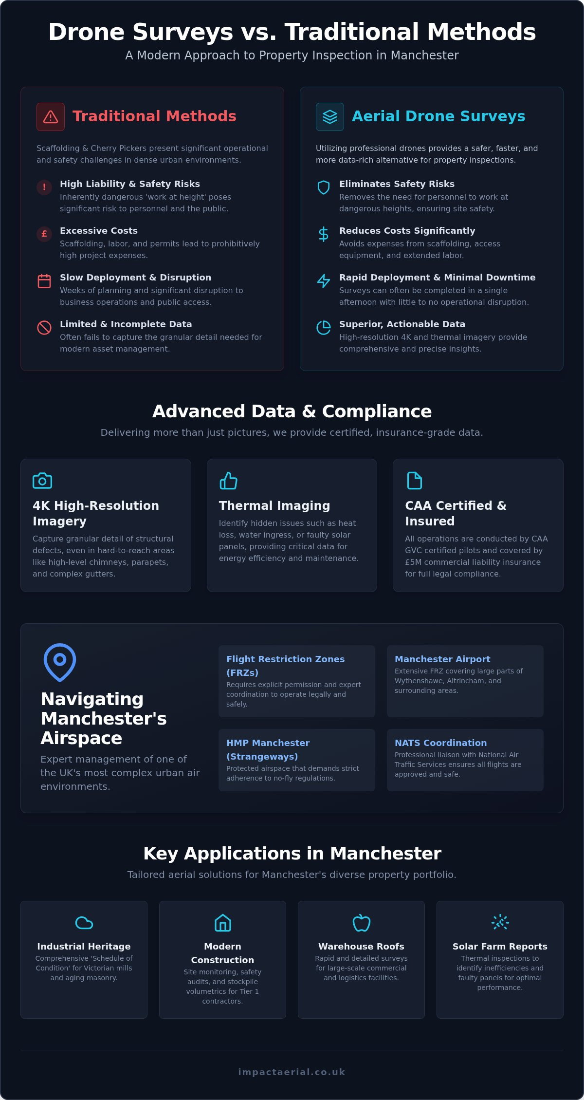
Comparing Drone Surveys to Traditional Access Methods
For many property managers, the decision between traditional access and aerial data collection comes down to a simple calculation of speed and risk. A professional drone survey manchester can be completed in a matter of hours, whereas erecting scaffolding for a similar inspection can take days or even weeks of logistical planning. This rapid turnaround doesn’t just save time; it allows for a more agile approach to building maintenance where issues are identified and resolved before they escalate into costly structural failures.
The difference in data resolution is equally stark. Ground-based inspections or surveys conducted from ladders provide a limited, oblique view of a building’s upper reaches. Our DJI Enterprise drones capture high-resolution 4K imagery from vertical and top-down perspectives that are physically impossible to achieve from the ground. This provides a level of detail that allows surveyors to zoom in on individual brick ties, mortar joints, or hairline cracks in chimney stacks with absolute clarity.
Scaffolding vs. Drone Inspections
Scaffolding, while once the only viable option for high-level work, carries significant hidden costs that go beyond the initial hire fee. In Manchester’s city centre, you have to account for pavement licenses, local authority permits, and the potential for building downtime. There’s also the security risk of leaving a climbing frame attached to your property for weeks. A drone survey manchester bypasses these hurdles entirely. We can access difficult areas like internal courtyards and deep valley gutters that would be prohibitively expensive to reach with traditional platforms. Additionally, drone operations are zero-emission, offering a more sustainable alternative to the heavy machinery and transport required for large-scale scaffolding projects.
Safety and Risk Mitigation
Safety remains the most compelling reason to choose aerial inspections. Removing the need for personnel to work at height significantly reduces the risk profile of any construction or maintenance site. Since falls from height are a leading cause of workplace injuries in the UK, eliminating this requirement provides immediate psychological comfort and tangible liability reduction for site owners. Our thermal imaging capabilities add another layer of safety by identifying dampness or heat loss without the need for invasive testing. You can see our guide to drone inspections for a deeper technical breakdown of how we use these advanced sensors to protect your assets and your workforce. By choosing a provider with £5m commercial liability insurance and CAA GVC certified pilots, you ensure that your survey is not only accurate but fully compliant with the highest industry standards.
Applications of Aerial Data Collection in Manchester
Energy efficiency is a primary concern for Greater Manchester’s ‘Green Building’ initiatives. We use DJI Enterprise thermal sensors to create high-accuracy heat-loss maps, helping property owners identify insulation gaps and structural thermal bridges. This technology is particularly effective for identifying issues with Reinforced Autoclaved Aerated Concrete (RAAC) in older public and commercial buildings, where thermal anomalies can indicate moisture ingress within the panels. Our specialized PV solar farm thermal surveys are another critical application. By detecting faulty cells that have overheated, we help operators maximize their return on investment and maintain peak performance across their renewable energy portfolios.
Post-Production and Data Analysis
The value of a professional drone survey manchester lies in what happens after the drone lands. Raw 4K footage is just a starting point; the real power comes from our post-production and data analysis pipeline. We transform thousands of individual images into high-resolution orthomosaic maps. These are georeferenced, 2D representations of a site that allow for precise measurements of area and distance with centimetre-level accuracy. For construction clients, this data can be integrated into Scan-to-BIM workflows, providing a digital twin of the project at specific points in time. Our specialists edit this raw data into actionable architectural reports, ensuring you have the qualitative evidence required for insurance claims or planning applications. If you’re ready to move from raw data to actionable insights, you can book a professional drone survey for your next project.
Choosing Impact Aerial for Your Manchester Drone Project
Selecting a partner for a drone survey manchester requires more than just looking at a portfolio of aerial photographs. It’s about choosing an operator who understands the gravity of industrial safety and the intricate requirements of urban aviation law. We’ve built our reputation on being a meticulous technical consultant rather than a flashy creative agency. Our focus remains on delivering the reassurance and reliability that commercial clients need when inspecting high-value property or monitoring multi-million pound construction sites across the North West. We treat every flight as a precision operation where data accuracy and regulatory compliance are the primary objectives.
Our Professional Standards
Our operations are underpinned by a commitment to the highest industry standards. Every pilot in our team is CAA GVC certified, which represents the gold standard for visual line of sight operations in congested urban areas. We don’t just show up and fly. Our process begins with a detailed feasibility study and a site-specific risk assessment that accounts for the unique challenges of the Manchester landscape. This meticulous planning is backed by £5m in commercial liability insurance, providing essential psychological comfort to asset managers and stakeholders. We utilize commercial-grade DJI Enterprise drones equipped with 4K HDR sensors and thermal imaging capabilities. These are high-precision industrial tools designed for data integrity. Our in-house post-production team then processes this raw data into the orthomosaic maps and architectural reports discussed earlier, ensuring a seamless end-to-end service from the initial consultation to final data delivery.
Get a Quote for Your Manchester Survey
Initiating your project is a straightforward and transparent process. When you contact us, we’ll discuss your specific site location and survey objectives to determine the most effective flight plan and sensor choice. Whether you need a detailed condition report for a warehouse in Trafford Park or a thermal inspection for a renewable energy asset, we provide a clear roadmap for data collection. We believe in a transparent approach to project management. This means providing clear timelines for airspace permissions and being upfront about the risk assessment outcomes for flights near restricted zones like Manchester Airport. Our goal is to act as a technical extension of your team, providing the specialist knowledge required to operate safely in complex environments. We’re ready to help you unlock the benefits of aerial data for your next project. Contact Impact Aerial today for a professional drone survey quote.
Elevating Property Intelligence in Manchester
Manchester’s architectural landscape is evolving fast, and traditional inspection methods can’t keep pace with the efficiency and safety required for modern asset management. By choosing a professional drone survey manchester, you eliminate the inherent safety risks of working at height while gaining access to high-resolution 4K HDR data that ground-based teams simply can’t provide. We’ve explored how navigating the city’s complex flight restriction zones requires a meticulous approach to compliance and coordination with local authorities.
Our commitment to your project’s security is backed by CAA GVC certified pilots and £5m in commercial liability insurance. We use industrial DJI Enterprise hardware to ensure that every pixel of data is accurate and actionable for your architectural or maintenance reports. Whether you’re managing a heritage mill renovation or a high-rise construction project, we provide the technical expertise to deliver results without the logistical downtime of scaffolding.
Ready to optimize your property data? Request a Professional Drone Survey Quote for Manchester and take the first step toward a safer, more efficient inspection process. We look forward to supporting your next project with precision aerial insights.
Frequently Asked Questions
Is it legal to fly a drone for a survey in Manchester city centre?
Yes, it is entirely legal provided the operator holds the correct Civil Aviation Authority (CAA) certifications and operational authorizations. In a dense urban environment like Manchester, a professional pilot must hold a General Visual Line of Sight Certificate (GVC). This ensures the flight is conducted within a strict safety framework. We manage all necessary legal permissions to ensure your aerial inspection is fully compliant with UK aviation law.
What are the Flight Restriction Zones (FRZs) in Manchester?
The most significant Flight Restriction Zones in the region are Manchester Airport and HMP Manchester. The airport’s FRZ is particularly large, extending into several surrounding residential and commercial districts. Conducting a drone survey manchester within these areas requires formal coordination with National Air Traffic Services (NATS) and the airport’s air traffic control tower. We handle this complex bureaucratic process to secure the required flight windows safely.
How much does a drone survey in Manchester typically cost?
Project costs are determined by several variables, including the site’s location, the complexity of the airspace, and the specific data sensors required. A simple visual roof inspection has a different cost profile than a large-scale topographic map or a thermal solar farm survey. We provide bespoke, transparent quotes based on your specific survey objectives and data deliverables, ensuring you receive a professional service tailored to your budget.
Do you need permission from Manchester City Council for a drone flight?
Permission is generally required if the drone’s take-off or landing point is on council-owned land or a public thoroughfare. For flights over private property, the primary requirement is the consent of the landowner. As part of our meticulous planning process, we verify current Manchester City Council policies for 2026. This ensures all local bylaws are respected and that the operation causes zero disruption to the public.
How long does a typical drone roof survey take to complete?
A standard commercial roof survey usually takes between two and four hours on-site. This rapid turnaround is one of the primary benefits of aerial data collection compared to traditional scaffolding, which can take days to erect. The exact duration depends on the building’s footprint and architectural complexity. Our DJI Enterprise hardware allows for efficient data capture, ensuring we minimize our time on-site while maximizing the resolution of the imagery collected.
What insurance coverage is required for professional drone surveys?
Professional operators must hold specialist commercial drone liability insurance that meets EC 785/2004 standards. We maintain £5m in commercial liability insurance, which is the recognized industry standard for high-value urban projects. This level of coverage provides essential reassurance and reliability for asset managers. It ensures that your business is fully protected against third-party risks while we operate in the challenging environments of Manchester’s busy commercial districts.
Can drones perform inspections in bad weather like rain or high winds?
While industrial drones have high wind resistance and certain IP ratings for moisture, we prioritize data quality and safety. Heavy rain can obscure camera lenses and affect the accuracy of thermal sensors. If weather conditions exceed our strict safety parameters, we reschedule the flight to the next available clear window. This commitment to safety-first operations ensures that the data you receive is always of the highest professional standard.
What kind of data will I receive after the drone survey is finished?
You will receive a comprehensive data package tailored to your project. This typically includes high-resolution 4K HDR imagery and, where requested, specialized thermal heat-loss maps or georeferenced orthomosaic overlays. For construction clients, we provide data compatible with BIM workflows and precise site measurements. Our post-production team processes the raw data into an actionable architectural report, identifying structural defects or maintenance issues with high-tier precision and clarity.
 2 Norton Drive, Wythall, Birmingham, B47 6HH Company registration number: 11138586. VAT Number: 366 9068 55


