
Optimising Marketing with Aerial Content: The 2026 Strategic Guide

What if the breathtaking drone shot you just posted is actually doing more harm than good to your brand’s bottom line? In 2026, simply capturing a bird’s-eye view isn’t enough to stand out in a rapidly expanding UK content marketing market. True success comes from optimising marketing with aerial content by shifting from spectacle to strategy. While many businesses worry about the new 100g registration threshold or the mandatory Remote ID requirements that took effect this January, the real risk lies in failing to turn high-end production into measurable ROI.

It’s understandable to feel hesitant about the high costs of professional videography or the intricacies of CAA compliance. You want a competitive edge in visual storytelling without the legal headaches or the uncertainty of how these visuals fit into your existing sales funnels. You’ll learn how to transform breathtaking drone visuals into a high-converting marketing engine that builds trust and delivers measurable ROI. We’ll explore how to integrate 4K HDR visuals into your digital platforms, navigate the latest 2026 regulations with confidence, and build brand authority through meticulous production standards.

Key Takeaways

  • Understand why high-authority aerial perspectives trigger psychological trust signals and how they’ve evolved into essential storytelling tools for 2026.
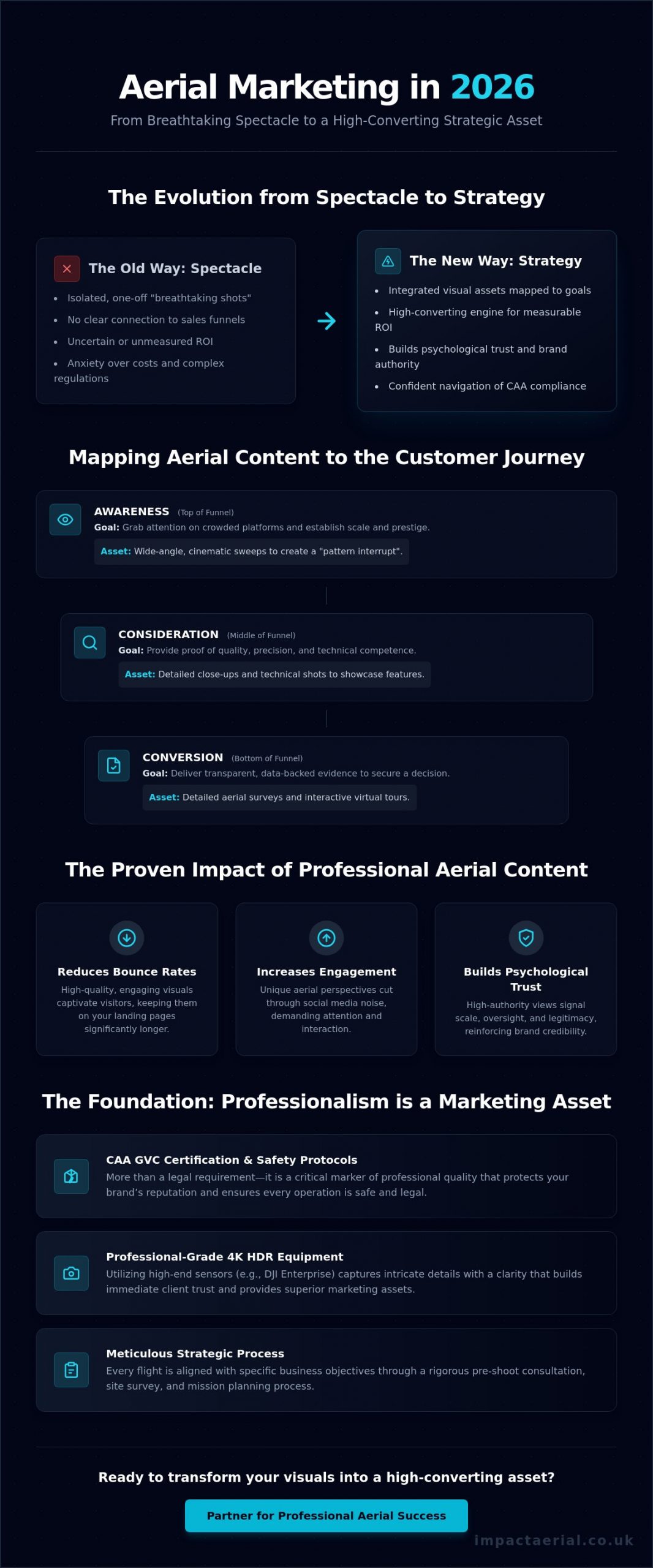
  • Discover the strategic framework for optimising marketing with aerial content by mapping visual assets to specific stages of the customer journey, from initial awareness to final conversion.
  • Learn how professional aerial filming and photography can reduce bounce rates on landing pages and significantly increase engagement metrics compared to traditional ground-level media.
  • Recognise why CAA GVC certification and rigorous safety protocols are more than just legal requirements; they’re critical markers of professional quality that protect your brand’s reputation.
  • Master the pre-shoot consultation and site survey process to ensure every flight is meticulously aligned with your specific business objectives and technical requirements.

The Evolution of Aerial Content in Modern Marketing

The concept of The Evolution of Aerial Content has moved far beyond the novelty of simply having a drone in the sky. In 2026, savvy UK brands are focused on optimising marketing with aerial content by treating every flight as a strategic asset rather than a one-off visual. This shift involves moving away from isolated clips and toward integrated storytelling that reinforces brand authority. When a viewer sees a high-altitude perspective, their brain subconsciously registers a sense of scale and legitimacy that ground-level filming struggles to replicate. It’s a powerful psychological trigger that signals a company’s oversight and professional reach.

To better understand the power of this visual medium, watch this helpful video:

Achieving this level of influence requires professional-grade equipment and a clear understanding of the marketing funnel. There’s a vast gap between basic consumer footage and the 4K HDR output produced by DJI Enterprise hardware. High-end sensors capture the intricate details of a construction site or the sprawling layout of a commercial property with a clarity that builds immediate trust. This technical precision serves every stage of the journey. At the Top of the Funnel, cinematic sweeps grab attention on crowded digital platforms. At the Bottom of the Funnel, detailed aerial surveys provide the transparent, data-backed evidence that converts a lead into a client.

Why Static Images No Longer Suffice

The decline of stock photography in professional UK marketing is a reality brands can’t ignore. Audiences have developed a blindness to staged office scenes and repetitive ground-level imagery. Unique aerial perspectives offer a necessary pattern-interrupt in busy social feeds, demanding engagement through a viewpoint that feels both exclusive and grand. This psychological impact elevates a brand’s perceived value. It demonstrates a commitment to high-end production and meticulous detail that standard photography simply can’t match.

The Shift to Data-Driven Visuals

Modern marketing demands more than just beauty; it requires proof. Using aerial content for construction site monitoring or PV solar farm thermal surveys turns a marketing asset into a technical record of competence. This transparency is a powerful tool for building trust with stakeholders who value precision over promises. It’s a sophisticated method of optimising marketing with aerial content by showing, not just telling, the scale and health of your operations. Aerial marketing is the fusion of cinematic art and technical precision.

Strategic Integration: Beyond the “Breathtaking Shot”

Effective marketing in 2026 requires more than just a visually pleasing clip. It demands a structured approach to optimising marketing with aerial content by mapping every frame to the customer journey. At the awareness stage, wide-angle cinematic sweeps establish the scale and prestige of a project. As the lead moves toward consideration, the focus shifts to technical precision, using detailed close-ups to provide proof of quality. Every flight must adhere to the UK Civil Aviation Authority Drone Code, ensuring that these high-value assets are captured legally and safely, protecting your brand’s reputation from the outset.

The transition from raw footage to a high-converting asset happens in the edit suite. Post-production is where marketing optimisation truly takes shape, as professional editors refine 4K HDR data into a cohesive narrative. This process includes the development of interactive virtual tour creation, which allows potential clients to explore a site from their own devices. This level of transparency is a powerful trust-builder. It’s often the deciding factor for stakeholders who require data-backed evidence before committing to a contract. If you’re ready to elevate your visual strategy, consider how professional aerial filming can bridge the gap between interest and investment.

Hero Content for Websites and Landing Pages

The first three seconds of a homepage video are critical for SEO and user retention. High-impact aerial footage serves as the ultimate “Hero” content, providing immediate location context that reduces bounce rates. When optimising marketing with aerial content for the web, technical balance is key. We use 4K HDR output to maintain visual authority while meticulously optimising file sizes. This ensures your site remains fast and responsive, which is a core requirement for both search engine rankings and a smooth user experience.

Social Media Mini-Series and Teasers

Social media platforms demand a diversified content strategy. We deliver aerial assets in both horizontal formats for LinkedIn and vertical orientations for Instagram Reels. Loopable drone shots are particularly effective as high-engagement backgrounds for text-heavy announcements. Don’t overlook the power of “behind the scenes” footage. Showing the meticulous pre-flight checks and the sophisticated hardware involved in a shoot humanises your brand. It demonstrates a commitment to professional standards and technical excellence that resonates with a modern, discerning audience.
Optimising Marketing with Aerial Content: The 2026 Strategic Guide

Maximising ROI Across UK Digital Channels

Measuring the success of a visual campaign requires more than just counting likes or views. In 2026, the real value lies in how these assets influence conversion rates and shorten sales cycles. While 87% of marketers report that video marketing has helped them increase website traffic, integrating professional drone photography provides a distinct engagement boost that standard ground-level videography lacks. This “Trust Dividend” is a direct result of high production value. It suggests a level of investment and professionalism that reassures potential clients they’re dealing with a meticulous industry leader.

Optimising marketing with aerial content involves tracking specific Key Performance Indicators (KPIs) across different digital platforms. For instance, click-through rates (CTR) on property listings see a significant uplift when aerial perspectives are included. The ability to see a property’s exact position relative to local amenities or transport links removes a layer of uncertainty for the buyer. This transparency isn’t just a visual perk; it’s a critical data point that accelerates the decision-making process. By providing a comprehensive view, you’re effectively answering a lead’s most pressing questions before they’ve even asked them.

Sector-Specific ROI: Property and Real Estate

The “Location Context” factor remains a primary driver for ROI in the UK property market. Buyers often pay a premium when they can clearly visualise the boundaries and surroundings of a site. By integrating high-resolution aerial shots into real estate photography packages, agents can create a more immersive experience. Immersive FPV drone fly-throughs are particularly effective here. They allow a viewer to travel from the street level, through the front door, and out over the garden in one seamless motion. This drastically reduces time-on-market by pre-qualifying leads who have already “experienced” the layout virtually.

B2B Marketing for Construction and Industry

In technical sectors, aerial assets serve a dual purpose as both operational tools and high-end marketing collateral. Regular construction site monitoring provides a transparent record of project progress that can be shared with stakeholders to build confidence. This data-centric approach is vital for optimising marketing with aerial content in B2B environments. Showcasing technical competence through thermal imaging or precision survey data proves your brand operates with meticulous accuracy. Long-term brand storytelling also benefits from time-lapse aerial footage. It captures the entire lifecycle of a project in a way that ground-based cameras cannot match, demonstrating your capacity and reliability to future clients.

The Compliance Advantage: Why Safety is a Marketing Asset

Choosing a drone operator based solely on the lowest price is a strategic error that can result in significant brand damage. In 2026, the traceability of aerial operations is absolute due to the mandatory Remote ID requirements for all UK-class drones. If a business uses footage captured by a non-compliant pilot, they aren’t just saving money; they’re inheriting a legal liability. Optimising marketing with aerial content requires a foundation of total legality. When a brand presents professional visuals, the audience assumes the operation was conducted safely. If that trust is broken by a regulatory investigation or a safety incident, the marketing value of the content evaporates instantly, replaced by a public relations crisis.

Professionalism in this industry is defined by more than just a sharp eye for a cinematic sweep. It’s built on a framework of risk mitigation and official certification. High-tier B2B pitches, particularly in the construction and public sectors, now demand proof of £5 million commercial liability insurance as a standard entry requirement. This coverage isn’t just a safety net; it’s a powerful trust signal. It tells your clients that you’ve partnered with a meticulous specialist who understands the gravity of industrial operations. By prioritising compliance, you transform a technical necessity into a hallmark of your brand’s commitment to excellence.

Understanding UK Drone Regulations in 2026

The regulatory landscape has become more complex with the introduction of UK-specific drone classifications from UK0 to UK6. Any commercial project now requires a pilot who understands these nuances, including the lowered registration threshold of 100g for Flyer IDs. Securing a professional UK drone license is no longer optional for serious marketing endeavours. A GVC certification guarantees operational safety by proving the pilot has undergone rigorous theoretical and practical assessments audited by the CAA. This ensures that every flight, regardless of the environment, is backed by a comprehensive risk assessment and a legal flight plan.

Transparency as a Trust Signal

Integrating your safety credentials directly into your marketing collateral is a sophisticated way of optimising marketing with aerial content. It addresses the “Peace of Mind” factor that corporate and public sector clients prioritise. When you’re transparent about how you manage public privacy concerns and adhere to strict flight restriction zones, you build a layer of brand authority that competitors often overlook. This meticulousness reassures stakeholders that their project is in expert hands. To ensure your next project meets these rigorous standards and protects your brand’s reputation, explore our fully compliant aerial filming services.

Implementation: Partnering for Professional Aerial Success

Successful implementation begins long before the aircraft enters the sky. To achieve the best results when optimising marketing with aerial content, you must align your technical requirements with your specific business goals. A meticulous pre-shoot consultation is the foundation of this process. It allows for a detailed site survey where we evaluate environmental factors and lighting conditions to ensure the highest quality 4K HDR output. This stage isn’t just about aesthetics; it’s a critical safety step where we finalise CAA-compliant flight plans and risk assessments tailored to your specific location. Identifying potential hazards early ensures the shoot proceeds without technical or legal interruptions.

The technical journey continues into post-production. Raw footage, while impressive, requires professional refinement to become a high-converting branded asset. Our process involves precise colour grading and format optimisation, ensuring that the final media is perfectly suited for its intended platform. Whether you’re creating a cinematic hero video for a website or a technical time-lapse for a construction report, this stage is vital for optimising marketing with aerial content. The transition from raw data to a polished marketing tool is what defines professional success. This structured approach ensures that every frame serves a purpose in your wider marketing funnel and delivers the authority your brand deserves.

The Impact Aerial Workflow

Our methodical workflow is designed to provide total reassurance and high-tier results. We follow a clear, three-stage process for every project to maintain our meticulous standards:

  • Pre-Flight Strategy: Initial consultation to define objectives, followed by rigorous site surveys and comprehensive airspace checks.
  • Precision Execution: On-site filming using advanced DJI Enterprise hardware, managed by GVC-certified pilots with a focus on safety and precision.
  • Post-Production Excellence: Professional editing and colour correction to ensure branded assets are ready for immediate deployment.

Selecting the Right Aerial Partner

Choosing a partner requires more than just looking at a portfolio. You need a specialist who understands the logistical nuances of your specific region. For businesses in Birmingham and the West Midlands, local knowledge of regional Flight Restriction Zones (FRZs) and urban flight challenges is essential for maintaining strict compliance. When evaluating a provider, ensure they meet the professional standards of industry leaders. Check for valid GVC certifications, comprehensive insurance coverage, and a proven track record of drone services in your sector. If you’re ready to start your next project, enquire about our professional aerial filming and photography services to ensure your brand’s vision is captured with technical precision and total legal compliance.

Elevating Your Brand Strategy for 2026 and Beyond

The shift toward optimising marketing with aerial content represents a fundamental change in how UK businesses communicate scale and authority. By moving beyond the simple spectacle of a drone shot and integrating data-driven visuals into your full marketing funnel, you create a transparent and high-converting experience for your audience. We’ve explored how professional standards and CAA compliance act as powerful trust signals, protecting your brand while delivering measurable results across digital platforms. This strategic approach ensures that every flight contributes directly to your bottom line.

Success in this specialized field requires a partner who combines cinematic vision with technical precision. Our team of CAA GVC Certified Pilots utilizes DJI Enterprise 4K HDR Technology to capture every detail with meticulous accuracy. Backed by £5m Commercial Liability Insurance, we provide the psychological comfort and professional reliability your corporate or industrial projects demand. It’s time to move past generic imagery and embrace a sophisticated visual narrative that sets your brand apart.

Ready to transform your visual storytelling into a strategic engine for growth? Request a bespoke quote for your aerial marketing project today. We look forward to helping you reach new heights with absolute precision and safety.

Frequently Asked Questions

How does aerial content improve my website’s SEO?

Aerial content improves SEO by increasing dwell time and reducing bounce rates. Search engines prioritize high-quality video content that provides a comprehensive user experience. By including unique perspectives, you’re optimising marketing with aerial content through improved engagement signals. This rich media demonstrates authority and keeps visitors on your page longer, which is a key ranking factor for modern algorithms.

Is drone footage legal for commercial marketing in the UK?

Drone footage is legal for commercial marketing in the UK provided the operator adheres to Civil Aviation Authority (CAA) regulations. As of January 2026, this includes having a valid Flyer ID for drones over 100g and an Operator ID. Professional pilots must also ensure their aircraft is equipped with Remote ID and comply with the specific UK class markings required for legal operation in various environments.

What is the difference between 4K and 4K HDR drone video for marketing?

The primary difference lies in the dynamic range and colour accuracy. Standard 4K provides high resolution, but 4K HDR (High Dynamic Range) captures significantly more detail in the brightest highlights and deepest shadows. This results in a more lifelike, professional image that doesn’t suffer from “blown out” skies or murky foregrounds. For high-end marketing, HDR is the standard for maintaining visual authority and quality.

Can aerial content be used for social media marketing like Instagram Reels?

Yes, aerial content is highly effective for short-form vertical platforms like Instagram Reels and TikTok. We capture footage specifically for these formats or crop high-resolution 4K horizontal shots in post-production. These unique, high-altitude perspectives create an immediate pattern-interrupt in social feeds, which is essential for optimising marketing with aerial content on mobile-first platforms where engagement is won in the first second.

How much does professional drone filming cost for a marketing campaign?

The cost of professional drone filming varies based on project complexity, location, and the required technical output. Factors such as the need for specialized sensors like thermal cameras or the intensity of post-production editing will influence the final investment. We provide bespoke quotes that reflect the specific operational risks and hardware requirements of your campaign to ensure a high-quality, compliant result that protects your brand.

Do I need special insurance if I hire a drone pilot for my business?

You don’t need to provide insurance yourself, but you must verify that your chosen pilot holds valid commercial liability insurance. Under UK law, commercial drone operators must have insurance that is compliant with EC 785/2004. We maintain £5 million in commercial liability coverage to provide total peace of mind and satisfy the rigorous risk management requirements of corporate and public sector clients across the UK.

What industries benefit most from aerial marketing content?

While many sectors benefit, the construction, commercial property, and renewable energy industries see the highest impact. These sectors rely on showing scale, progress, and technical health. For example, PV solar farm thermal surveys and construction site monitoring provide both marketing value and critical operational data. Any business that manages large physical assets or sprawling locations will find significant value in these specialized perspectives.

How long does it take to produce a professional drone marketing video?

A standard drone marketing project typically takes between three to seven working days from the initial flight to final delivery. This timeline includes a day for site surveys and flight planning, the filming day itself, and several days for meticulous post-production. Complex projects involving virtual tour creation or extensive colour grading may require additional time to ensure the final assets meet our high-tier quality and technical standards.
Virtual Tour for Schools and Universities: The 2026 Guide to Immersive Campus Marketing

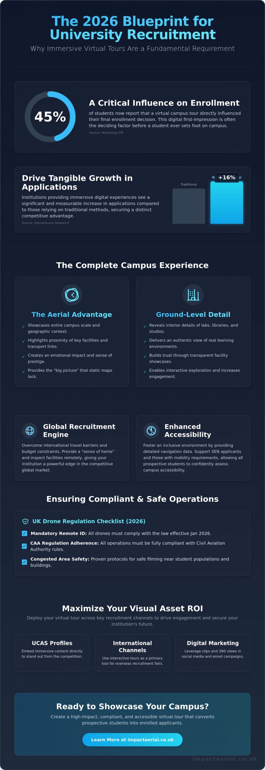
Did you know that 45% of students now report that a virtual campus tour influenced their final enrollment decision? According to research from Marketing LTB, the digital experience is often the deciding factor before a student ever sets foot on your grounds. It’s understandable if you’re concerned about declining physical open day attendance or the difficulty of reaching international applicants. You need a way to showcase your facilities that feels both authentic and prestigious, yet the perceived complexity of drone safety on a populated campus can feel like a significant hurdle. Implementing a professional virtual tour for schools and universities is the most effective way to bridge this gap.

This 2026 guide explains how to navigate the transition from simple video to fully integrated aerial and ground-based immersion. You’ll learn how these assets enhance accessibility for SEN applicants and provide a long-term competitive edge. We’ll also cover essential technical standards, such as the mandatory Remote ID requirements for UK-classified drones that became law in January 2026. This ensures your marketing remains both high-impact and fully compliant with Civil Aviation Authority regulations. You’ll discover how to deploy a high-end visual asset that drives engagement and secures your institution’s future.

Key Takeaways

  • A professional virtual tour for schools and universities has evolved from a marketing luxury into a fundamental requirement for securing student enrollment in the 2026 competitive landscape.
  • Discover how to seamlessly integrate high-resolution aerial perspectives with internal ground-based scans to showcase both campus scale and specific student facilities.
  • Enhance institutional accessibility by providing detailed navigation data that supports SEN applicants and those with physical mobility requirements.
  • Navigate complex UK drone regulations and safety protocols to ensure compliant filming within congested campus environments and near student populations.
  • Learn strategies to maximize visual asset ROI by embedding immersive content into UCAS profiles and interactive international recruitment channels.

The Strategic Importance of Virtual Tours for Schools and Universities in 2026

A What is a Virtual Tour is no longer defined as a simple sequence of static 360-degree images. In the 2026 education sector, it has evolved into a sophisticated, multi-layered digital environment that allows users to navigate complex campus geographies remotely. This technology has transitioned from an optional marketing “extra” to a fundamental operational requirement. As physical open day attendance faces logistical challenges, a high-fidelity virtual tour for schools and universities acts as a 24/7 “always-on” gateway, ensuring your institution remains accessible to a global audience regardless of time zones or travel constraints.

The impact on conversion rates is measurable and significant. According to Eduventures Research, institutions that provide immersive digital experiences see a 16% increase in applications compared to those that rely on traditional brochures. By offering a transparent view of facilities, libraries, and social spaces, you move prospective students from a state of passive interest to active applicant status. This digital-first approach provides the reassurance families need when making one of the most significant financial and personal decisions of a student’s life.

To better understand how a premier institution utilizes this technology to showcase its unique atmosphere and facilities, watch this helpful video:

Meeting the Expectations of Gen Z and Gen Alpha Students

Today’s applicants are visual-first decision makers who view high-resolution 4K HDR content as the new baseline for professional credibility. If your digital presence feels dated, students may assume your campus technology is equally behind the curve. We use interactive elements and subtle gamification to increase “dwell time,” encouraging students to explore lab spaces or creative studios in detail. This focus on authenticity ensures that the virtual tour for schools and universities reflects real learning environments, building the trust necessary to convert digital visitors into enrolled students.

International Recruitment and the Global Campus

International recruitment is a primary driver of institutional growth, yet the barriers to entry for overseas students are often high. Immersive tours reduce these hurdles by providing a “sense of home” before a student even boards a plane. Families can inspect accommodation standards and campus safety features from their own living rooms, overcoming travel restrictions or budget constraints. This level of technical transparency provides a competitive edge in a crowded global market, allowing your institution to project its values and facilities to every corner of the world with precision and authority.

The Aerial Advantage: Why Your Campus Tour Needs Professional Drone Integration

Ground-only scans are useful for interior spaces, but they often fail to communicate the geographic context and scale of an institution. A comprehensive virtual tour for schools and universities uses aerial perspectives as an interactive “home base.” This allows prospective students to understand the proximity between lecture halls, student accommodation, and local transport links. It provides the essential big picture that static maps cannot match, giving families a true sense of the campus environment before they arrive.

Using 4K HDR drone cinematography creates an immediate emotional impact that ground photography alone cannot replicate. High-quality visuals of sprawling sports facilities or historic architecture provide a sense of prestige and institutional pride. Transitioning from a wide aerial shot directly into a ground-level classroom scan creates a seamless journey. This prevents the disjointed feeling of clicking through separate image galleries and keeps the user immersed in the experience.

Capturing the ‘Big Picture’ of University Estates

Large campuses are often difficult to navigate on foot, making it hard for prospective students to visualize the true scale of the estate. Professional drone filming highlights green spaces, modern architecture, and local landmarks in a single, sweeping shot. Aerial footage creates a cohesive campus narrative by visually bridging the physical distance between academic buildings and social hubs, turning a collection of structures into a unified community.

Technical Excellence: 4K HDR and Post-Production

We utilize professional-grade DJI Enterprise equipment because it offers superior stability and image sensors compared to consumer-level drones. This hardware ensures that even in challenging lighting or high-contrast environments, the output remains crisp and professional. Our post-production services focus on stitching these aerial and ground assets with meticulous precision. We apply consistent colour grading and lighting adjustments to ensure the transition from the sky to the internal hallway feels natural and high-end.

Operating in busy campus environments requires strict adherence to UK Civil Aviation Authority drone regulations. Safety is our primary metric for success, and we manage every aspect of risk mitigation, from initial flight planning to final delivery. If you are looking to elevate your institution’s digital presence, consider how integrated aerial filming can transform your next recruitment cycle. We provide the technical expertise and regulatory compliance necessary to capture stunning campus visuals safely and effectively.

Virtual Tour for Schools and Universities: The 2026 Guide to Immersive Campus Marketing

Enhancing Accessibility and Inclusion with Virtual Campus Navigation

While the visual impact of a virtual tour for schools and universities is a powerful recruitment tool, its most profound value often lies in its ability to foster genuine inclusion. For many prospective students, especially those with Special Educational Needs (SEN) or physical disabilities, the unknown geography of a new campus can trigger significant campus anxiety. By providing a meticulous digital twin of the environment, institutions offer a safe and predictable space for neurodivergent applicants to explore at their own pace. This technical transparency removes the “fear of the unknown” that often acts as a barrier to application.

This digital-first approach empowers parents and carers to vet facilities for specific requirements before a physical visit is even scheduled. It ensures that the transition to higher education is managed with precision and care. When an institution provides this level of detail, it sends a clear message of reliability and reassurance to families who need to know their students will be supported in a safe, accessible environment.

SEN-Friendly Features in Modern Virtual Tours

We integrate specific features designed to reduce cognitive load and provide sensory clarity for users. These include audio descriptions for key locations and “quiet space” markers that identify low-sensory environments across the campus. Predictable navigation paths are essential; they ensure that the user experience remains logical and consistent, preventing the disorientation that can occur with poorly structured digital interfaces. Using these tours for pre-arrival familiarisation is a proven strategy to reduce first-day stress. It allows students to map out their routes from student housing to lecture theatres with complete confidence, knowing exactly what to expect when they arrive.

Physical Accessibility and Estate Transparency

A truly inclusive virtual tour for schools and universities prioritises the visibility of physical accessibility features. This isn’t just about showing a building; it’s about providing actionable data for students with mobility challenges. Our tours focus on:

  • Highlighting accessible entrances equipped with ramps, wide-access points, or automated doors.
  • Identifying the exact locations of lifts and specialised facilities, such as hydrotherapy pools or accessible laboratory stations.
  • Providing clear, visual data on accessible routes that avoid stairs, steep gradients, or narrow corridors.

These assets can be integrated with existing campus maps to provide real-time navigation assistance. Demonstrating this level of estate transparency is a clear statement of an institution’s commitment to diversity and inclusion. It ensures that every student, regardless of their physical or sensory requirements, feels welcomed and supported from their very first interaction with the university’s digital presence.

Planning and Compliance: Navigating UK Regulations for Campus Drones

Operating a drone within an educational environment requires far more than basic piloting skills; it demands a rigorous commitment to national aviation standards. For any professional virtual tour for schools and universities, the safety of students and staff is the absolute priority. This is why employing a pilot with a General Visual Line of Sight Certificate (GVC) is essential. Unlike basic consumer permissions, a GVC allows for complex operations in congested areas, which is a common requirement for busy school grounds or urban university campuses. In the 2026 regulatory environment, this certification is the primary indicator of a pilot’s competence and legal authority to operate in sensitive locations.

Risk mitigation doesn’t end with the pilot’s license. Educational institutions must ensure their contractors hold a minimum of £5 million in commercial drone liability insurance. This level of coverage is the industry standard for schools, providing the necessary financial and legal protection for the estate and its inhabitants. A professional operator will provide a comprehensive site risk assessment before any equipment leaves the ground, ensuring that all flight paths are cleared and that potential hazards are identified and managed with precision. We ensure every flight is planned with meticulous attention to the specific geography of your campus.

Understanding CAA Regulations for Educational Sites

The regulatory landscape for drone operations is precise and authoritative. Professional pilots must adhere to the latest UK Drone License: A Simple Guide to CAA Rules in 2026 to ensure full compliance with current laws. Beyond flight safety, privacy laws and GDPR are critical factors when filming on an active campus. We use advanced post-production techniques to ensure that any identifiable student data is managed according to strict privacy protocols, maintaining the institution’s legal standing while capturing high-end visual assets. This grounded approach to technology ensures that your marketing remains compliant and ethical.

The Production Timeline: What to Expect

A successful capture begins long before the drone takes off. Pre-flight planning involves detailed stakeholder notification, ensuring that staff, students, and parents are informed of filming schedules well in advance. We meticulously monitor weather patterns to select the ‘golden hour’, those periods of soft, directional light that ensure maximum visual impact for your facilities. The production process typically follows a structured path:

  • Site Survey: Identifying optimal launch points and potential signal interference.
  • Data Capture: Executing the flight plan and ground-based interior scans.
  • Post-Production: Integrating interactive hotspots, embedded videos, and institutional branding into the final virtual tour for schools and universities.

If you require a compliant, high-end visual solution for your campus, contact our GVC-certified team to discuss your project requirements and ensure your next marketing asset is delivered safely and professionally.

Maximising ROI: How to Deploy Your Virtual Tour Across Marketing Channels

A high-end virtual tour for schools and universities is a versatile digital asset that should perform across your entire recruitment funnel. Rather than treating it as a standalone link, institutions must integrate these immersive experiences directly into their UCAS profiles and primary course landing pages. This ensures that the 45% of students who use these tours to influence their final decision encounter your facilities at the most critical point of their journey. By embedding the tour where applicants already spend their time, you provide a frictionless transition from digital browsing to formal application.

Data-centric institutions use these tours to gain a competitive edge through detailed engagement analytics. Unlike traditional brochures, a digital tour allows you to track exactly which facilities prospective students value most. If analytics show high dwell time in your new engineering labs or sports complexes, you can adjust your broader marketing strategy to highlight those specific strengths. Research from Enrollment Rx indicates that universities utilising these interactive tools engage 30% more prospects than those relying on static media, providing a tangible return on your technical investment.

Guided virtual tours represent a significant shift in international recruitment. During live-streamed open days, admissions officers can take control of the user’s screen to lead a remote group through the campus in real-time. This interactive approach allows for immediate Q&A sessions while visually showcasing faculty expertise and student testimonials via embedded hotspots. These hotspots act as deep-dive points where users can trigger video interviews or 3D views of specialised equipment, adding layers of social proof to the visual experience.

Social Media and Short-Form Content

Your investment in high-resolution visuals provides a wealth of material for social media. We recommend repurposing 4K aerial footage into high-impact teaser clips for TikTok, Reels, and YouTube Shorts. These short-form assets drive significant traffic back to the full interactive experience, capturing the attention of Gen Z and Gen Alpha audiences who prioritise visual-first platforms. For a deeper understanding of how to capture these professional assets, see our guide on Aerial Filming Drone: The Ultimate Guide to Professional Cinematic Video.

The Future of Admissions: VR and Augmented Reality

As we look toward the next decade, preparing your tour for VR headsets is essential for high-traffic recruitment fairs and exhibitions. Providing an immersive headset experience at a physical stand creates an immediate emotional connection that static banners cannot replicate. Impact Aerial ensures all content is future-proofed by capturing data at resolutions that exceed current web standards, allowing for seamless transitions into evolving augmented reality platforms. To secure your institution’s digital future, you can request a consultation for your school’s virtual tour with our technical specialists today.

Securing Your Institution’s Digital Future

Adopting a professional virtual tour for schools and universities is no longer a secondary marketing consideration; it’s a foundational requirement for any institution aiming to thrive in the 2026 global education market. By integrating technical precision with immersive storytelling, you provide prospective students and their families with the transparency they need to make informed decisions. Whether you’re highlighting the scale of your campus through 4K HDR aerial perspectives or ensuring accessibility for SEN applicants, these visual assets create a lasting impact that traditional media cannot match.

Operational safety and regulatory compliance remain the cornerstones of our work. We offer the reassurance of CAA GVC certified pilots and £5m commercial liability insurance, ensuring every flight on your campus is conducted with meticulous attention to risk mitigation. This expert approach allows you to focus on your recruitment goals while we manage the technical complexities of data capture and post-production. It’s time to transform your digital presence into a high-end visual experience that drives enrollment for years to come.

Ready to showcase your campus with industry-leading precision? Book a Professional Virtual Tour Consultation with Impact Aerial today and take the first step toward a more immersive recruitment future.

Frequently Asked Questions

How much does a virtual tour for a school or university cost?

The investment required for a virtual tour for schools and universities depends on several technical factors, including total campus acreage and the number of internal spaces requiring high-resolution scans. Costs are also influenced by the complexity of aerial-to-ground transitions and the inclusion of custom interactive hotspots. We provide bespoke quotations following a thorough site assessment to ensure the project scope aligns with your institution’s specific recruitment goals and budgetary requirements.

How long does it take to create a full campus virtual tour?

A typical production timeline for a comprehensive tour ranges from four to eight weeks from the initial site survey to final delivery. This period includes meticulous pre-flight planning, on-site data capture, and the post-production phase where aerial and ground assets are stitched together. Larger university estates with multiple satellite sites may require a phased delivery schedule to ensure consistent lighting and visual quality across all digital nodes.

Is it safe to fly drones on a school campus with students present?

It’s entirely safe when managed by GVC-certified pilots who adhere to the mandatory Remote ID requirements and UK drone classifications that became law on January 1, 2026. We mitigate risk through rigorous flight planning and the use of professional-grade hardware with built-in redundancy systems. Filming is often scheduled during low-occupancy windows or “golden hour” periods to minimise disruption while maintaining our strict standards for commercial liability and operational safety.

Can we update the virtual tour ourselves if we build a new building?

Most professional virtual tours are built on a modular framework, allowing us to scan and integrate new facilities without rebuilding the entire experience from scratch. While your team can often update text-based hotspots or external links via a content management system, capturing new 4K HDR imagery requires professional equipment to maintain visual consistency. This ensures that new developments are presented with the same technical precision and high-end finish as the original estate.

Do virtual tours work on mobile phones and tablets?

Every virtual tour for schools and universities we produce is fully responsive and optimised for mobile, tablet, and desktop viewing. This cross-platform functionality is critical for reaching Gen Z and Gen Alpha applicants who primarily engage with recruitment content on smartphones. The interface automatically scales to the user’s device, ensuring that interactive elements, navigation paths, and high-resolution visuals remain crisp and functional regardless of the hardware used.

What is the difference between a Matterport tour and an aerial-integrated tour?

A Matterport tour typically focuses on internal 3D scans which are excellent for interiors but lack the broader geographic context of a large estate. An aerial-integrated tour bridges this gap by using drones to provide the “big picture” of the university’s layout and surrounding environment. By combining these technologies, you allow prospective students to fly over the campus and “drop in” to specific buildings, creating a seamless journey from the sky to the classroom.

How do we handle privacy and GDPR when filming students?

We manage privacy through a combination of strategic scheduling and advanced post-production anonymisation. Our pilots work closely with your estate management team to film in zones that have been cleared of identifiable individuals, or we use blurring technology to anonymise faces and vehicle registration plates. This ensures your marketing assets remain fully compliant with GDPR and institutional privacy policies while still projecting an authentic and welcoming atmosphere for prospective applicants.

Can we include student interviews or videos inside the virtual tour?

You can integrate high-definition video testimonials and faculty interviews directly into the tour via interactive hotspots. This creates a multi-layered experience where a student can click on a specific lab bench or studio to watch a video of a peer explaining a research project. These embedded assets add significant social proof and academic authority, transforming a simple visual scan into a powerful, interactive recruitment tool that builds trust with your audience.

How Aerial Videography Increases Engagement: The Science of High-Altitude Marketing

Could a simple change in perspective be the difference between a high-value lead and a lost impression? You’ve likely felt the frustration of watching major construction projects or premium estates get buried under low engagement rates. It’s difficult to convey the true scale of a complex development through a standard handheld lens. Understanding how aerial videography increases engagement is now essential for brands that want to avoid looking generic next to competitors. We believe your marketing should reflect the same precision and quality as your physical assets.

The gap between consumer and enterprise equipment is significant. Our fleet includes DJI Enterprise grade drones equipped with 4K HDR sensors. These sensors capture a wider dynamic range, ensuring that shadows and highlights are preserved even in challenging lighting. This technical superiority is why professional aerial videography increases engagement; the resulting footage has a cinematic weight that hobbyist equipment cannot replicate. Specialists like Light Colour Sound use their 20 years of experience in Advertising, Cinema, and TV to ensure that high-altitude visuals achieve this premium production quality. Professional pilots possess the technical skill to execute complex lateral orbits and reveals that guide the viewer’s eye toward your primary call to action.

This article explores the psychological and strategic reasons why high-altitude visuals stop the scroll, increase dwell time, and convert viewers into customers. You’ll discover the science of cognitive pattern-interrupts that reset viewer attention spans. We’ll also examine the authority gained by using CAA GVC Certified operators to deliver top-quality results. As of May 2026, the transition to UK class marks and Remote ID requirements means that professional, compliant filming provides the peace of mind your brand needs to stand out as a market leader.

Key Takeaways

  • Learn why the ‘Scroll-Stop’ effect acts as a cognitive pattern interrupt that bypasses banner blindness in saturated digital feeds.
  • Explore the vestibular-visual connection and how 3D parallax effects drive viewer retention by creating a satisfying, immersive experience.
  • Identify how aerial videography increases engagement in the construction and property sectors by using contextual awareness to build immediate buyer trust.
  • Discover the strategic importance of the ‘First 3 Seconds’ rule and HDR post-production in converting casual viewers into high-value customers.
  • Understand why professional CAA GVC certification is a vital trust signal that separates premium brand authority from amateur efforts.

The ‘Scroll-Stop’ Effect: Why Aerial Videography Captures Attention Instantly

In the fast-moving feeds of LinkedIn or Instagram, the ‘Scroll-Stop’ effect is a cognitive pattern interrupt that forces a user to pause. Most digital content is filtered out by ‘banner blindness’, a mental shortcut where the brain ignores predictable advertising layouts. High-altitude marketing bypasses this by providing a perspective the human eye doesn’t experience daily. This immediate visual shift is a primary reason why aerial videography increases engagement, as it triggers ‘instant curiosity’ and improves click-through rates (CTR) compared to standard ground-level shots. Understanding the history and diverse applications of this technology shows that it has evolved from a niche military tool into an essential commercial asset.

To better understand how these visuals impact viewer behaviour, watch this helpful video:

Initial retention rates in the first 3 seconds are critical for social media success. If a video doesn’t provide immediate value or visual interest, the viewer moves on. Aerial perspectives provide that value instantly. By revealing the full scope of a project or the surrounding environment in the opening frame, you establish context that would otherwise take minutes of ground-level footage to explain. This efficiency is why professional firms are increasingly turning to high-altitude visuals to maintain audience attention in a saturated market.

Breaking the ‘Eye-Level’ Monopoly

Approximately 90% of marketing video content is filmed between 1.5 and 1.8 metres. This ‘eye-level’ perspective is the default for handheld cameras and smartphones, making it highly predictable. When a viewer encounters a sudden shift to an aerial view, the brain signals ‘new information’ and prioritises the visual. The sheer scale of a construction site or a 50-acre estate captured from above provides a sense of grandeur that ground-based cameras cannot replicate. This scale doesn’t just look better; it validates the importance of the project in the viewer’s mind.

Engagement Metrics: What ‘Success’ Looks Like

True engagement goes beyond vanity metrics like ‘likes’ or ‘shares’. For professional firms, success is measured by dwell time and the reduction of bounce rates on landing pages. Data suggests that including high-quality drone footage can keep a visitor on a page for significantly longer periods. In terms of performance, engagement for an aerial filming drone is defined by its ability to maintain high watch-time percentages by delivering perspectives that ground-based alternatives simply cannot provide. By capturing never-before-seen angles, brands improve their authority and create a ‘premium’ feel that converts casual viewers into serious enquiries.

The Psychology of Perspective: How Aerial Movement Drives Viewer Retention

Stopping the scroll is only the first step in a successful marketing campaign. To understand how aerial videography increases engagement, we must look at why the human brain remains fixed on high-altitude movement. This is largely driven by the ‘Vestibular-Visual Connection’. When a camera follows a smooth, stabilised path through space, it mimics the sensation of fluid movement. This creates a satisfying, almost hypnotic experience for the viewer. Unlike shaky handheld footage that can cause minor cognitive dissonance, professional drone paths feel intentional and authoritative. They signal to the viewer that they are in the hands of a specialist who values precision.

Elevated perspectives also trigger the ‘God View’ effect. This psychological phenomenon occurs when a viewer sees a landscape or project from a height that implies total oversight. It creates a sense of awe and establishes the brand as a dominant, organized entity. By showcasing a construction site or commercial property from 40 metres, you aren’t just showing a building; you are demonstrating the scale of your operation. This authority is a key driver in converting a curious viewer into a high-intent lead. If you want to see how these perspectives apply to your specific industry, you can view our professional filming services to see the impact of high-altitude storytelling.

The Power of Parallax in Drone Filming

Parallax is a technical effect where objects in the foreground appear to move faster than objects in the background. In professional drone videography, this creates an unmistakable sense of 3D depth. Standard ground shots often feel flat because the camera doesn’t have the freedom to move through multiple planes of depth simultaneously. By using a lateral ‘orbit’ or a ‘dolly’ move at height, we create an immersive feel that makes the subject matter look more valuable. This depth perception is a primary reason why aerial videography increases engagement; it provides a spatial understanding that ground-based cameras simply cannot replicate.

Storytelling Through Continuous Movement

The ‘One-Take’ allure is a powerful storytelling tool. Following a subject from ground level and rising into a sweeping skyward reveal builds anticipation. These cinematic reveals keep viewers watching until the final frame. To achieve a truly professional result, drone photography and videography work together to tell a cohesive brand story by providing both the detailed precision of a still image and the immersive narrative of continuous movement. This combination ensures that every angle is covered, providing peace of mind to clients who need their large-scale projects presented with absolute clarity.

Movement also serves a practical purpose by guiding the viewer’s eye. A slow, forward ‘push-in’ shot acts as a visual funnel, directing attention toward a specific call to action, such as a site entrance or a finished development. By the time the shot concludes, the viewer has been led exactly where you want them to go. This strategic use of movement ensures your marketing isn’t just visually impressive; it’s functionally effective.

Beyond the ‘Pretty Shot’: Practical Applications That Boost Industry Engagement

While cinematic visuals provide an immediate aesthetic lift, the true commercial value lies in how aerial videography increases engagement within specific industry sectors. It isn’t just about a “bird’s eye view”. It’s about providing data and context that ground-based photography lacks. For instance, aerial coverage of corporate events or industry trade shows leads to 40% higher shareability on platforms like LinkedIn and Instagram compared to standard event photography. This surge occurs because high-altitude shots capture the collective energy and scale of an event in a single, comprehensive frame. This makes the content more “share-worthy” for attendees and stakeholders alike.

Engagement in a professional context is often a byproduct of trust. By showing the full scope of a project or a property’s surroundings, you remove the “blind spots” that often lead to consumer hesitation. This transparency is a powerful tool for building brand authority. Whether you are managing a large-scale construction site or marketing a premium commercial estate, the ability to show the entire footprint from above provides your audience with a sense of security and clarity. Our professional services are designed to provide this exact peace of mind, ensuring that your marketing assets are as meticulous as your operations.

Real Estate: Selling the Lifestyle, Not Just the House

In the property sector, high-quality visuals are the primary driver of lead quality. Showing a building’s surroundings through “Contextual Awareness” builds immediate trust with prospective buyers. They don’t just want to see the interior; they want to see the proximity to transport links, green spaces, and local infrastructure. This comprehensive view increases time-on-page for listings by over 100% in many cases. For commercial developers, a professional drone survey acts as both a technical record and a high-engagement marketing asset. It proves the value of the property through undeniable visual evidence.

Construction and Infrastructure: Transparency as Engagement

Construction firms use “Progress Engagement” to keep stakeholders and investors informed throughout a multi-year project. Aerial monitoring provides a clear, methodical view of site development that ground cameras cannot replicate. By deploying survey drone technology, project managers deliver “insider” views that showcase precision and adherence to timelines. These data-gathering missions are often compiled into “Year in Review” videos. These videos serve as powerful authority-building tools for future bids. This methodical approach ensures that clients feel they are in safe, expert hands. It turns raw technical data into a compelling narrative of growth and reliability.

Optimising Your Aerial Content: Strategies for Maximum Engagement and ROI

Capturing high-altitude footage is only half the battle. To understand how aerial videography increases engagement, you must look at how that footage is refined and delivered. The ‘First 3 Seconds’ Rule is the most critical factor in digital marketing. Users decide whether to stay or scroll almost instantly, so your video must start with its most dramatic aerial reveal. This immediate visual hook is best presented using 4K High Dynamic Range (HDR) technology. Content that lacks professional colour grading or appears washed out will fail to build brand authority. When considering how aerial videography increases engagement, the technical precision of the final edit is just as vital as the flight itself.

Post-Production: Where Engagement is Won

The editing suite is where raw data is transformed into a compelling brand narrative. Professional post-production services ensure that fluid visual paths are perfectly synced with immersive sound design. Research from May 2026 suggests that pairing sweeping visuals with high-fidelity audio can double viewer retention rates compared to silent clips. Additionally, adding motion graphics or text overlays allows you to communicate project specifications without losing the viewer’s attention. A single methodical drone shoot can be repurposed into over 12 high-engagement social assets, ranging from short vertical clips for mobile to full-length widescreen features for corporate presentations.

Timing and Lighting for Maximum Visual Impact

Lighting determines the emotional response and perceived value of the subject matter. The ‘Golden Hour’, occurring shortly after sunrise or before sunset, provides the long shadows and warm tones that make commercial property and construction sites look their best. To maintain high engagement levels, individual aerial clips should follow a strict 5-second rule. Long, lingering shots without a clear focal point often lead to ‘drone fatigue’, causing viewers to drop off. Mixing these high-altitude reveals with ground-based footage creates a steady communication rhythm that keeps the audience invested in the story.

Format your content specifically for the intended platform to maximise your return on investment. Data indicates that vertical video formats see 28% higher completion rates on mobile devices compared to traditional landscape crops. Ensuring your content is optimised for every screen size is a hallmark of a meticulous marketing strategy. To start building your library of high-impact visual assets, contact our professional aerial filming team for a consultation.

Professionalism as an Engagement Driver: Why CAA Certification and Safety Matter

High-quality visuals are essential, but the technical execution of a flight is what preserves brand authority. Amateur drone footage often features jittery movement, poor exposure, or “propeller shadow” that can actually hurt brand engagement. When a viewer sees low-quality or unstable video, they subconsciously associate that lack of precision with your business. Professional drone services are a necessity for corporate clients who require a premium finish. Meticulous flight planning ensures that the focus remains on the subject matter rather than technical flaws.

Safety and compliance act as silent trust signals for your audience. Displaying that you work with a CAA GVC Certified operator demonstrates a commitment to industry standards and public safety. As of May 2026, the UK regulatory landscape requires strict adherence to Remote ID and UK class mark standards. Using a pilot who holds a valid drone license and follows the Drone Code provides the peace of mind necessary for large-scale projects. This professional alignment is a core component of how aerial videography increases engagement; it reassures stakeholders that your marketing assets were produced legally and ethically.

Risk mitigation is another factor that separates specialists from hobbyists. We maintain £5m in commercial liability insurance to protect our clients and the public during every mission. In a niche but increasingly diverse market, this level of officialdom prevents potential PR disasters associated with unlicensed or unsafe drone operations. By choosing a vetted operator in Birmingham and the West Midlands, you ensure that your brand remains a trusted leader in your sector.

The Difference Between a ‘Drone Hobbyist’ and a Professional Pilot

The gap between consumer and enterprise equipment is significant. Our fleet includes DJI Enterprise grade drones equipped with 4K HDR sensors. These sensors capture a wider dynamic range, ensuring that shadows and highlights are preserved even in challenging lighting. This technical superiority is why professional aerial videography increases engagement; the resulting footage has a cinematic weight that hobbyist equipment cannot replicate. Professional pilots possess the technical skill to execute complex lateral orbits and reveals that guide the viewer’s eye toward your primary call to action.

Your Next Steps: Elevating Your Visual Strategy

To maximise engagement, your aerial brief should focus on the specific outcomes you want to achieve. Are you looking to showcase the scale of a construction project or the luxury feel of a new estate? Integrating this content into your existing marketing funnel is straightforward. Aerial clips can be used as high-impact website headers, LinkedIn background videos, or short-form social media reels. Each asset should be designed to reduce bounce rates and improve dwell time.

If you are ready to move beyond generic marketing and embrace the science of high-altitude marketing, we can help. Contact Impact Aerial today for a professional consultation on your next project. We provide the technical expertise and regulatory compliance needed to showcase your business from a perspective that truly stops the scroll.

Transform Your Marketing with High-Altitude Precision

Mastering the science of high-altitude marketing is no longer optional for brands in the construction or commercial property sectors. We’ve explored how cognitive pattern-interrupts stop the scroll and how technical factors like 4K HDR sensors drive viewer retention. By now, it’s clear that understanding how aerial videography increases engagement involves a blend of psychological triggers and meticulous technical execution. Relying on amateur footage risks your brand’s reputation; instead, professional services provide the authority and safety required for high-stakes projects.

Impact Aerial provides the expertise you need for peace of mind. As specialists in Birmingham and the West Midlands, our team consists of CAA GVC Certified pilots backed by £5m commercial liability insurance. We ensure your content is fully compliant with the latest May 2026 UK drone regulations, including Remote ID and class mark standards. Don’t let your projects look generic next to the competition. Elevate your brand with professional aerial videography from Impact Aerial. We look forward to helping you capture perspectives that truly resonate with your audience.

Frequently Asked Questions

How much does aerial videography increase social media engagement?

Data from May 2026 indicates that social media posts featuring high-quality aerial footage see an 80% higher click-through rate (CTR) compared to standard image-based posts. This is largely due to the cognitive pattern-interrupt mentioned earlier in this article. By providing a perspective that bypasses banner blindness, brands see a significant lift in shares and comments across platforms like LinkedIn and Instagram.

Do I need a special license to use drone footage for my business in the UK?

Yes, you must comply with Civil Aviation Authority (CAA) regulations. As of May 2026, anyone responsible for a drone weighing 250g or more, or any drone with a camera weighing over 100g, must hold a valid Operator ID which costs £12.34 per year. For professional commercial work, using a CAA GVC Certified pilot ensures your project is legal and covered by specialist insurance.

What is the best length for a drone marketing video?

The optimal length for a comprehensive aerial feature is between 60 and 90 seconds. While short 5-second clips are best for social media “scroll-stopping”, longer features allow for a methodical narrative that keeps 50% of viewers engaged until the final frame. This duration provides enough time to showcase the scale of a project without causing viewer fatigue.

Can aerial videography be used for indoor engagement, like warehouses or factories?

Indoor aerial filming is a powerful tool for showcasing logistics and manufacturing scale. Specialist drones can navigate factory floors to provide a fluid, continuous tour that ground-based cameras can’t replicate. This immersive perspective helps potential clients understand your operational capacity, leading to higher trust and improved dwell time on your corporate website.

Is drone footage better than traditional ground-based video for real estate?

It is a vital secondary tool that provides spatial understanding. While ground shots show the interior, drone footage reveals the roof condition and land boundaries, which are priorities for 80% of commercial buyers. This transparency is a key reason how aerial videography increases engagement, as it provides the full visual data required to make an informed decision.

What industries benefit the most from aerial videography?

Construction, commercial property development, and large-scale infrastructure projects see the highest return on investment. These sectors rely on demonstrating scale and progress to stakeholders. By using 4K HDR sensors to capture site monitoring data, firms can provide “insider” views that keep investors engaged throughout the lifecycle of a multi-year project.

How does the weather in the UK affect the quality and engagement of drone shots?

UK weather requires meticulous planning to maintain high engagement levels. Professional pilots typically ground flights if wind speeds exceed 20mph or if heavy rain is present to ensure shot stability. We monitor weather patterns to capture footage during the “Golden Hour”, as the lighting at this time provides the best emotional response from viewers.

Does professional drone video provide a better ROI than DIY footage?

Professional video offers a superior ROI by protecting your brand authority. DIY footage often suffers from “propeller shadows” or jittery movement, which can drive away high-value leads. With £5m in commercial liability insurance and expert post-production, professional services provide the peace of mind and “premium” feel necessary to convert viewers into long-term customers.

Virtual Tour for New Build Homes: The Developer’s Guide to Immersive Marketing in 2026

What if you could sell a property 31% faster and for up to 9% more, without spending tens of thousands on a physical show home? According to recent industry data from Matterport, that’s the precise advantage developers are gaining. It’s an undeniable reality in property development; the traditional model of relying on static 2D floor plans and costly show homes struggles to capture the imagination of today’s digitally-native buyers, especially for off-plan sales.

This guide is engineered to demonstrate how a professionally produced virtual tour for new build homes is no longer a luxury, but a fundamental component of a modern marketing strategy. You’ll discover exactly how immersive, drone-captured experiences can slash your time-on-market, generate qualified leads around the clock, and solidify a premium brand image that justifies higher asking prices. We’ll break down the technology, the return on investment, and the strategic steps you need to take to gain a decisive competitive edge in the 2026 property market.

Key Takeaways

  • Learn why static photography no longer meets the expectations of digital-first buyers and how immersive experiences provide a crucial competitive edge.
  • Discover how combining ground-level 360° cameras with aerial drone data creates a sales tool that showcases the entire development context.
  • Analyse the cost-benefit of a professional virtual tour for new build homes and see how it can accelerate off-plan sales while reducing marketing costs.
  • Understand the essential steps for planning a successful shoot and the importance of choosing a CAA GVC certified and fully insured operator for your project.

Beyond Show Homes: The Evolution of Virtual Tours for New Build Developments

The concept of a virtual tour is no longer a simple sequence of 360-degree photographs. By 2026, a professional virtual tour for new build homes is a fully-interactive, photorealistic digital twin of an unbuilt property. It’s a data-rich environment created from architectural plans and CGI, allowing prospective buyers to explore every room, customise finishes, and understand the spatial dynamics long before a single foundation is poured. For a technical overview, you can explore What is a Virtual Tour? to understand its core technology. This evolution is critical; static 2D photography simply doesn’t meet the expectations of today’s digital-native buyers, a demographic where, according to a 2022 Statista report, 98% of individuals under 30 own a smartphone and expect immersive digital experiences.

This immersive quality has a profound psychological impact on sales. When a potential buyer can virtually ‘walk through’ a property, they begin to form an emotional connection and a sense of ‘mental ownership’. This isn’t just a feeling; it translates into measurable results. Real estate listings featuring high-quality 3D tours see up to 40% more user engagement than those without. This heightened connection directly correlates with increased lead quality and faster conversion rates. Beyond the sales floor, this technology also supports the crucial ‘Green Building’ narrative. By providing a perfect digital replica, developers can significantly reduce the carbon footprint associated with property viewings, eliminating countless non-essential car and air journeys from speculative buyers.

The Shift to Off-Plan Digital Selling

For property developers, the most significant advantage is the ability to secure deposits months or even years before project completion. This digital-first approach drastically reduces the reliance on constructing and fitting out expensive physical show homes, which can cost anywhere from £50,000 to over £150,000 per unit. A virtual tour provides a superior, more flexible asset at a fraction of that cost, while also empowering sales teams to reach a global audience of international and out-of-area investors who can view and commit to a property from anywhere in the world.

Meeting the 2026 Buyer Expectations

The widespread availability of high-bandwidth 5G networks across the United Kingdom means buyers expect and receive a flawless, buffer-free tour experience on their mobile devices. Modern tours are enhanced with interactive hotspots; a user can click on the kitchen worktop to see material specifications, on an appliance to download the manufacturer’s warranty, or on a window to see the precise view. These tours are no longer standalone assets; they are designed for seamless integration with major UK property portals like Rightmove and Zoopla and are easily shared across social media platforms, amplifying marketing reach exponentially.

The Technology Powering Immersive Property Experiences

Creating a truly effective virtual tour for new build homes goes far beyond a simple 360-degree photograph. It involves a meticulous process of data acquisition, combining high-resolution ground-based imagery with comprehensive aerial data to build a complete digital asset. The goal isn’t just to show a property; it’s to deliver a spatially accurate, emotionally resonant experience that gives potential buyers the confidence to commit, often before a single brick is laid. This requires a professional, data-centric approach, ensuring every pixel serves a commercial purpose.

The foundation of a premium tour lies in its visual fidelity. We exclusively utilise camera systems capable of capturing 4K High Dynamic Range (HDR) imagery. HDR technology is critical for property, as it correctly exposes both the bright view through a window and the subtle details of the interior in a single, seamless shot. This prevents the washed-out windows or dark corners common in lower-quality tours, presenting your build with the premium feel it deserves.

A key technical decision is the choice between standard 360 photography and photogrammetry. While standard 360s create an immersive “bubble” from a fixed point, photogrammetry uses hundreds of overlapping images to construct a metrically accurate 3D model. For a simple interior walkthrough, a 360 tour may suffice. For a comprehensive development overview that allows for virtual measurements and a true sense of scale, photogrammetry is the superior professional service.

Aerial Integration: The Impact Aerial Advantage

Our CAA GVC Certified pilots utilise industry-leading drone systems to capture the vital context that ground-based cameras cannot. We can fly to the exact coordinates of a third-floor window before the frame is even built, capturing the genuine “view from the window” for your marketing materials. This unique capability allows you to sell a specific plot’s key advantage months in advance. The aerial perspective seamlessly maps out local amenities, from the distance to the nearest primary school to the walking paths in the local park, transitioning from a bird’s-eye view right to the front door.

Software and Interactivity

The captured data is then processed into an interactive experience. While platforms like Matterport offer a robust, industry-recognised solution, we also provide custom-coded tours for developers requiring bespoke branding or specific API integrations. Within these tours, we can embed interactive tags containing everything from downloadable floor plans and BIM data to specifications for the kitchen appliances. This transforms the tour from a passive viewing into an active exploration, providing buyers with all the information they need in one place.

Perhaps the most powerful component is the analytics. We can track user engagement to see exactly where potential buyers are spending their time. Discovering that 80% of users linger in the master suite and open-plan kitchen provides your sales team with invaluable intelligence. This level of data-driven insight is a key reason why virtual technologies are poised to revolutionize the real estate industry, turning a visual asset into a source of actionable business intelligence. Understanding which technology is right for your development is the first step; you can see our professional services in action on past projects to learn more.

Comparing Virtual Tours to Traditional Marketing: ROI and Engagement

Adopting a virtual tour for new build homes is not merely an aesthetic upgrade; it is a strategic investment with a measurable return. Traditional marketing methods, such as static photography and physical show homes, have inherent limitations in reach, cost, and buyer qualification. High-quality digital assets deliver a quantifiable advantage by fundamentally changing how prospective buyers interact with a property before a physical viewing is ever scheduled.

The data on user engagement is compelling. According to real estate technology analysts at Zillow, listings that include a 3D tour receive a 40% increase in user engagement. Viewers don’t just glance; they explore. Industry-wide metrics show that potential buyers spend up to 10 times longer on a property listing that features an immersive tour compared to one with only 2D images. This extended interaction time directly correlates with a deeper level of interest and a higher probability of conversion.

A direct cost-benefit analysis reveals significant efficiencies. Consider the typical expenses for a single show home:

  • Physical Staging: A 6-week hire for a standard 3-bedroom property in the UK can cost between £2,500 and £5,000.
  • Professional Photography: A one-off shoot can range from £400 to over £1,000 for a comprehensive package.
  • Ongoing Overheads: Staffing, utilities, and maintenance for a physical show home represent a continuous financial drain.

In contrast, a professional virtual tour is a one-time investment, typically costing between £400 and £900. This single digital asset can be used across all marketing channels indefinitely, from the initial off-plan launch to the final plot sale. It effectively pre-qualifies buyers by allowing them to rule a property in or out from their own home, leading to reports of a 40% reduction in wasted physical viewings. This frees up your sales team to focus on genuinely interested, high-intent purchasers.

The ROI of Immersive Content

The financial return extends beyond direct cost savings. Data from Matterport, a leading platform in 3D capture, indicates that properties with virtual tours can sell up to 31% faster, drastically shortening the sales cycle and improving cash flow for developers. When used on targeted landing pages, these tours can increase lead generation by as much as 49%. By pre-qualifying buyers and answering spatial questions visually, virtual tours significantly reduce the administrative burden on sales teams, allowing them to handle more qualified leads with greater efficiency.

Brand Positioning and Competitive Edge

In a competitive new build market, a tech-forward approach is a powerful differentiator. Offering a superior digital experience positions your brand as modern, transparent, and customer-focused. This technology is also invaluable for off-plan sales, where virtual architectural visualizations allow buyers to experience a property that doesn’t yet exist, building the confidence needed to secure early commitments. Furthermore, the virtual tour serves as a permanent, high-resolution digital archive of the property’s condition at handover, a valuable tool for snagging lists and future reference, providing peace of mind for both developer and buyer.

This tech-forward branding can extend beyond the screen to the physical sales environment itself. For high-impact launch events or unique pop-up marketing suites, some developers are now using innovative structures to stand out. Companies such as Immersive Experiences offer geodesic domes that create a futuristic and memorable setting, perfectly aligning a developer’s physical presence with their digital-first strategy.

Planning Your Virtual Tour: A Step-by-Step Implementation Guide

Executing a high-quality virtual tour for new build homes is a methodical process that extends far beyond a simple photoshoot. It requires a structured, multi-phase approach to guarantee the final asset not only looks professional but also functions as a powerful sales tool. At Impact Aerial, we manage this entire workflow, ensuring every detail aligns with your development’s unique selling proposition.

The process is broken down into five distinct, professionally managed phases:

  • Phase 1: Scoping & Strategy. We begin with a detailed consultation to define the project’s scope. This involves identifying the key plots to capture and pinpointing the unique selling points, from the premium quartz worktops in the kitchen to the energy efficiency rating and the orientation of the south-facing garden.
  • Phase 2: Site Preparation. This crucial phase involves preparing the property and the wider site for data capture. We coordinate with your site manager to schedule the work and identify the optimal weather window for aerial operations.
  • Phase 3: Data Capture. Our CAA GVC Certified pilots execute the shoot day with precision. This is a coordinated effort, utilising ground-based 360° cameras for internal spaces and our DJI Enterprise drones for breath-taking external and contextual aerial views.
  • Phase 4: Post-Production. Raw data is processed into a seamless, interactive tour. We embed custom ‘info tags’ to highlight specific features, integrate floor plans, and perform professional colour grading to ensure the property is presented in its best light.
  • Phase 5: Deployment & Integration. The completed tour is delivered in a format ready for immediate integration into your website, property portals like Rightmove, and your CRM systems.

Preparing the Site for Capture

A pristine site is non-negotiable for achieving top-quality results. Internally, show homes must be staged to perfection: all surfaces decluttered, lights on, and personal items removed. A flawless paint finish is critical for a high-end look, and using a professional service like Higher Impact Painting can ensure the property is camera-ready. Externally, the site must be clear of construction debris and unnecessary vehicles. For aerial capture, our certified pilots establish strict safety zones in compliance with CAA regulations, ensuring the operation is conducted safely and without interruption. We schedule our drone property surveys during the ‘Golden Hour’, the first and last hour of daylight, as the soft, angled light dramatically enhances the texture and visual appeal of brickwork and landscaping.

Integration and Deployment

A virtual tour’s value is only realised when prospective buyers can easily access it. We provide a simple iframe embed code that allows you to integrate the tour directly onto your website without impacting page load speeds, a key factor for SEO performance as of Google’s 2021 Core Web Vitals update. For on-site marketing, QR codes on hoardings and sales literature offer a direct link for passers-by. With QR code usage in the UK having grown by over 90% since 2018, this is a highly effective way to engage local prospects. Finally, we advise training your sales team to use the tour as an active closing tool, guiding clients through the property on a large screen in the sales suite to build desire and overcome objections in real time.

To ensure every phase of your project is handled with professional precision, contact our certified team for a detailed project consultation and get your new build development seen and sold faster.

Why Impact Aerial is the Trusted Partner for UK Developers

Selecting a partner to create a virtual tour for new build homes goes beyond finding someone with a drone. It’s a decision about professionalism, safety, and brand integrity. At Impact Aerial, we provide a fully managed, compliant, and insured professional service designed specifically for the demands of UK property developers. Our process is built on four pillars: stringent safety compliance, comprehensive insurance, bespoke creative output, and meticulous project management.

Compliance and Safety Standards

Operating drones in residential or built-up areas is a highly regulated activity. Our pilots are all CAA GVC Certified, the required standard for complex commercial operations in the UK. This isn’t just a certificate; it’s your assurance that we can legally and safely navigate flight restrictions near buildings and people. Before any flight, we conduct a detailed risk assessment and site survey, identifying potential hazards and establishing a safe operational plan. Using an uncertified operator exposes your project to significant legal and financial risks, including CAA fines of up to £2,500 and the potential invalidation of your site’s insurance. For added peace of mind, all our operations are covered by £5 million in commercial liability insurance.

Tailored Solutions for Property Professionals

We understand that every development is unique. From our base in Birmingham, we have delivered projects for property professionals across the West Midlands and the entire UK. Our experience isn’t just in flying; it’s in understanding what developers need to see and what prospective buyers want to experience. For a recent 75-home development in Warwickshire, our phased aerial progress reports helped the developer secure stage-based funding, while the final virtual tour contributed to a 30% increase in qualified viewing appointments within the first month of its launch.

Our service extends far beyond the flight. The post-production process is entirely bespoke to your brand. We ensure every element aligns with your marketing collateral, including:

  • Brand Integration: Seamlessly embedding your logos, contact information, and plot details directly into the tour.
  • Colour Grading: Matching the video’s colour palette to your brochures and brand guidelines for a cohesive campaign.
  • Information Overlays: Highlighting key features, local amenities, and transport links to add tangible value for viewers.

Our comprehensive project management means we handle every detail, from the initial consultation and flight planning to the final delivery of your assets. We deliver a complete virtual tour for new build homes that is ready to be deployed on your website, property portals like Rightmove, and across your social media channels. To discover how we can elevate your next project, contact our team today for a bespoke, no-obligation quote tailored to your development’s specific requirements.

Your Blueprint for Immersive Marketing Success

The landscape for property marketing is irrevocably shifting. As we approach 2026, it’s clear that immersive digital experiences aren’t just a supplement; they are a fundamental component of a successful sales strategy. They provide unparalleled access for off-plan buyers and can significantly shorten the sales cycle by building trust and excitement long before a show home is even complete.

Executing a top-quality virtual tour for new build homes demands technical expertise and operational precision, making your choice of partner critical. At Impact Aerial, we provide the professional services UK developers trust, backed by CAA GVC Certified pilots and a state-of-the-art 4K HDR DJI Enterprise fleet. For your complete peace of mind, our operations are fully covered by £5m in Commercial Liability Insurance.

Ready to showcase your development with breath-taking clarity and secure your competitive edge? Book your professional virtual tour consultation with Impact Aerial and let’s build the future of property marketing together.

Frequently Asked Questions

How much does a virtual tour for a new build home typically cost?

A virtual tour for a single new build property typically costs between £300 and £700. The final price depends on the home’s square footage and the number of scan points required to create a complete, high-quality model. For entire developments or multi-property projects, we provide a bespoke quotation based on the full scope of work, which can include aerial drone integration and custom branding. This investment provides a powerful, long-term marketing asset.

Can you create virtual tours for off-plan properties that haven’t been built yet?

Yes, we create photorealistic virtual tours for off-plan properties using advanced CGI (Computer-Generated Imagery). By working directly from your architectural plans, such as CAD or BIM files, our team builds a detailed and immersive 3D model of the property before construction begins. This allows prospective buyers to explore the layout and finishes months or even years before completion, helping to accelerate your off-plan sales cycle significantly.

How long does it take to shoot and produce a full development virtual tour?

On-site scanning for a single new build show home typically requires 2-4 hours. For a full development, on-site data capture can take one to two full days, depending on the number of individual plots and exterior areas that need to be covered. Post-production, which includes processing the scans and building the final interactive tour, is generally completed within 48 to 72 hours, delivering a market-ready asset to you promptly.

Do I need special permits for drone photography on a construction site?

No, you don’t need to arrange any permits; we manage all aviation-related permissions as your certified operator. Impact Aerial is fully CAA GVC Certified and we conduct meticulous pre-flight risk assessments for every operation. We handle all necessary airspace checks to ensure full compliance with UK drone regulations. Your only responsibility is to grant us permission to operate on the site itself, giving you complete peace of mind.

Are virtual tours mobile-friendly for buyers browsing on their phones?

Yes, all our virtual tours are fully responsive and optimised for mobile devices. They provide a seamless, high-quality experience on any smartphone or tablet, across both iOS and Android platforms. With over 60% of UK web traffic now on mobile, according to 2023 Statista data, we ensure your potential buyers can explore properties from anywhere. The tours load efficiently and feature intuitive touch-based navigation for ease of use.

What is the difference between a 360 tour and a 3D walkthrough?

A 360 tour connects a series of static panoramic photos, allowing a user to look around from fixed points. In contrast, a 3D walkthrough is created by scanning a property to build a complete, geometrically accurate 3D model. This provides a true sense of presence, enabling users to move freely through the space as if they were there. Our 3D walkthroughs also include unique perspectives like the ‘dollhouse’ view for a comprehensive understanding of the property’s layout.

Can virtual tours be used for snagging and construction site monitoring?

Yes, a virtual tour for new build homes is a highly effective tool for construction management. The high-resolution imagery allows project managers and clients to conduct remote snagging inspections, zooming in on details without needing to be on-site. When captured at regular intervals, these scans create a precise digital timeline of progress, providing an accurate as-built record for handover and facilities management.

What happens if the weather is bad on the day of the drone shoot?

Your project’s safety and the quality of the final assets are our top priorities. We cannot operate drones in high winds (above 22 mph) or heavy rain, as this violates CAA safety regulations and degrades image quality. If inclement weather is forecast, we will reschedule the aerial photography for the next suitable day at no additional charge. The internal 3D scanning of the property can often proceed as planned regardless of the weather.

Drone Videography for Marketing: The Ultimate Guide to Boosting Engagement

Have you seen those stunning aerial shots in a competitor’s advert and wondered if they deliver a genuine return on investment? For many UK businesses, integrating professional drone videography for marketing can feel complex, expensive, and tangled in safety regulations. You might be asking: Is it worth the cost? What shots would even work for my industry? And how can I ensure everything is done legally and safely under CAA guidelines? These are valid concerns that can make a powerful marketing tool feel inaccessible.

This ultimate guide is designed to provide clarity and confidence. We will demystify the entire process, demonstrating how stunning aerial footage is a strategic asset for elevating your brand and driving measurable marketing results. You will discover creative ideas for your specific industry, learn how to assess the value of your investment, and understand what to look for when hiring a fully certified and insured professional. By the end, you’ll be equipped to captivate your audience from a new perspective, with complete peace of mind.

Key Takeaways

  • Discover how aerial footage provides a unique perspective that instantly captures viewer attention and showcases the full scale of your projects or properties.
  • Learn to strategically match specific drone manoeuvres to distinct marketing objectives, moving beyond generic footage to tell a compelling brand story.
  • A structured 3-step planning process is essential for transforming a creative idea into a successful and briefable drone videography for marketing campaign.
  • Understand the critical importance of hiring a CAA-certified and fully insured professional to ensure your project is safe, compliant, and delivers high-quality results.

Why Drone Videography is a Marketing Game-Changer

In today’s saturated digital landscape, capturing and holding audience attention is the primary challenge. Standard, ground-level photography and videography often fail to cut through the noise. Drone videography offers a powerful solution, instantly elevating your content by providing a dynamic, bird’s-eye view that commands attention. This unique perspective creates a profound sense of scale, context, and awe that is simply unattainable from the ground, allowing you to tell a more compelling and comprehensive story about your project, property, or brand.

To better understand how these dynamic shots are planned and executed, this professional masterclass offers valuable insights:

The Unmatched Power of a New Perspective

Aerial footage provides a comprehensive overview that ground-level shots cannot replicate. For instance, a commercial property listing can show not just the building itself, but its entire footprint, its proximity to major transport links, and the surrounding local amenities in a single, flowing shot. This holistic view provides immediate context and answers questions before they are even asked. The psychological impact of seeing a project in its entirety gives viewers a superior understanding and fosters a greater sense of trust and transparency. A deeper dive into understanding drone technology reveals how these advanced systems are engineered to provide stable, high-resolution perspectives once reserved for blockbuster film budgets.

Boosting Key Digital Marketing Metrics

The unique and engaging nature of aerial video directly translates into improved performance metrics across all digital platforms. Professionally produced drone content is proven to deliver tangible results:

  • Increased Watch Time: The cinematic quality of drone footage keeps viewers captivated for longer on platforms like YouTube and LinkedIn, increasing the visibility of your message.
  • Higher Engagement Rates: Breathtaking visuals are inherently shareable. This leads to higher click-through rates on advertisements and a significant increase in likes, comments, and shares on social media.
  • Improved Website Performance: Embedding high-quality aerial videos on your website can dramatically increase average session duration, signalling to search engines that your site provides valuable content.

Building Brand Prestige and Authority

Employing professional drone videography for marketing is a powerful statement about your brand. It communicates high production values, attention to detail, and a commitment to quality. This immediately elevates your brand’s perception, signalling that you are a modern, innovative, and successful leader in your industry. Luxury property developers, high-end resorts, and leading construction firms use aerial footage to create an exclusive feel and build an aura of prestige that distinguishes them from the competition and justifies a premium positioning in the market.

Strategic Applications: Matching Drone Shots to Marketing Goals

Effective drone videography for marketing moves beyond generic scenic footage; it requires a deliberate, strategic approach where every flight path and camera angle serves a specific business objective. This means planning each shot to align with a particular stage of the customer journey, from initial awareness to the final conversion. A professional operator understands that this is a technical discipline governed by strict safety protocols. While our operations are governed by the UK’s Civil Aviation Authority (CAA), the importance of compliance is a global standard, reflected in frameworks like the FAA commercial drone regulations in the United States. This commitment to professional standards ensures that your aerial video is not just visually stunning, but also a precisely targeted storytelling tool.

For Brand Awareness: Epic Establishing & Context Shots

To capture attention and make a memorable first impression, your goal is to generate awe and establish context. These shots are designed to be dramatic and shareable, positioning your brand, project, or location on a grand scale. Key manoeuvres include:

  • Reveal Shots: The drone ascends over an obstacle, such as a treeline or hill, to dramatically unveil the subject-be it a new property development, a sprawling event, or a stunning landscape. This builds anticipation and delivers a powerful impact.
  • Top-Down Shots: A direct overhead perspective is ideal for showcasing patterns, scale, and the layout of a site. This is invaluable for commercial property, agriculture, or events, providing a clear, map-like view that ground-level cameras cannot achieve.
  • Orbit Shots: By circling a key subject, you build intrigue and provide a comprehensive 360° view. This technique is perfect for highlighting a landmark building, a new vehicle, or a central feature of a property.

For Consideration: Informative Fly-Throughs & Tours

Once you have a prospect’s attention, the next step is to provide valuable information in an engaging format. This is where drone videography for marketing excels at giving potential customers a deeper understanding of your offering. Fly-throughs and tracking shots serve as dynamic virtual tours, guiding the viewer through a space or along a journey. A seamless flight through a commercial building, a luxury hotel, or an industrial facility offers a perspective that is far more immersive than a simple photo gallery. Similarly, tracking a vehicle along a scenic route or following a person through a resort demonstrates products and experiences in a real-world, narrative context.

For Conversion: Highlighting Key Features & Benefits

At the decision-making stage, your aerial footage must focus on the specific details that drive conversions. Low-altitude, detailed shots can precisely highlight key selling points-such as premium roofing materials, solar panel installations, outdoor amenities, or proximity to local transport links. For a complete picture, this high-quality aerial footage is often combined with ground-level video to move from the grand overview to the intricate details that matter most to a buyer. This powerful combination provides undeniable proof of value and helps close the sale. See how our professional pilots capture the perfect shot.

Drone Videography Across Industries: Real-World Marketing Examples

The true value of professional aerial footage is its remarkable versatility. Far from a one-size-fits-all solution, the strategic application of drone videography for marketing provides a tangible competitive advantage across a diverse range of UK sectors. By offering unique perspectives that ground-based cameras simply cannot achieve, drones solve specific commercial challenges and create powerful new storytelling opportunities. Here, we explore its impact on our key client industries: property, construction, and corporate branding.

Transforming Real Estate & Property Marketing

For estate agents and property developers, context is everything. Drone footage moves beyond static images to sell a complete lifestyle and location. It provides an unparalleled perspective that allows potential buyers to fully appreciate a property’s scale, its grounds, and its position within the wider community, building desire and justifying asking prices.

  • Compelling Listing Videos: A sweeping aerial shot that reveals a home’s stunning garden before flying over to show the short walk to the local village pub or train station.
  • Land & Plot Visualisation: Clear, top-down video that accurately showcases the boundaries of a large plot of land, its topography, and access points.
  • Neighbourhood Tours: Highlighting a property’s proximity to desirable amenities like parks, outstanding schools, and key transport links, providing crucial context for buyers.

Showcasing Construction & Development Projects

Communicating the scale, progress, and ambition of a construction project is a significant challenge. Drone videography offers a comprehensive solution, providing clear visual data for stakeholders and creating impressive marketing assets that convey the full scope of a development. This visual evidence builds confidence and is invaluable for progress reports and investor relations.

  • Project Time-lapses: A professionally edited time-lapse documenting a commercial build from foundation to completion, perfect for a company website or case study.
  • Stakeholder Updates: Regular, scheduled flights providing clear video updates for investors and clients, demonstrating that milestones are being met on time and on budget.
  • Investor Pitches: A cinematic video of the development site, showcasing its strategic location and vast potential to secure funding and attract commercial tenants.

Elevating Corporate Videos & Brand Storytelling

In a crowded digital landscape, high-production-value video helps a brand stand out. The use of drone videography for marketing adds a layer of cinematic quality and professionalism that elevates any corporate production. It allows businesses to tell their story on a grander scale, reinforcing their credibility and market leadership.

  • Cinematic Establishing Shots: An impressive opening shot of a company’s headquarters or manufacturing facility at sunrise, setting an authoritative tone for a brand story video.
  • Dynamic Event Coverage: Capturing the energy of an outdoor company event, team-building day, or sponsored charity run from unique and engaging aerial angles.
  • High-Quality B-Roll: Adding aerial footage of company operations or the surrounding landscape to client testimonials to increase visual interest and production value.

Planning Your Drone Video Marketing Campaign: A 3-Step Framework

A successful project is built on a foundation of meticulous pre-production planning. Moving from a general idea to a tangible, high-quality video requires a structured approach. This framework ensures that your investment in drone videography for marketing delivers a powerful return, aligning every flight and every shot with your commercial objectives. By defining your goals upfront, you ensure a smooth production process and a final asset that truly resonates with your audience.

Step 1: Define Your Core Message & Objective

Before any drone takes flight, clarity on your strategic goals is paramount. Begin by identifying the single most important action or feeling you want to evoke in your viewer. Is the primary objective to generate qualified leads for a new property development, build brand awareness by showcasing your facility’s scale, or provide a detailed look at a finished project? Understanding your target audience and the platforms they use-be it your corporate website, LinkedIn, or YouTube-will dictate the video’s tone, length, and format.

Step 2: Storyboard Key Aerial & Ground Shots

Translate your objectives into a visual plan. A simple shot list is an invaluable tool, outlining the essential aerial perspectives required to tell your story. Consider how these dynamic drone shots will integrate with ground-level footage, interviews, or on-screen graphics to create a compelling narrative. Think in terms of a beginning (an expansive establishing shot), a middle (detailed orbits and fly-bys of key features), and an end (a final reveal or a shot that reinforces your call to action).

Step 3: Prepare a Brief for Your Drone Partner

A comprehensive brief is the cornerstone of an effective partnership with your aerial provider. This document consolidates your planning into a clear set of instructions, ensuring an accurate quote and an efficient workflow. Your brief should outline:

  • Project Goals: The core objectives defined in Step 1.
  • Location & Logistics: The precise site address, any access considerations, and potential on-site hazards.
  • Shot List: Your desired aerial and ground shots from Step 2.
  • Brand Guidelines: Any specific fonts, colours, logos, or musical styles to be incorporated.
  • Timeline: Key deadlines for filming and final delivery.

Presenting a detailed brief to a professional, CAA GVC Certified operator like Impact Aerial ensures that every technical and creative aspect of your project is perfectly aligned with your vision from the start.

Hiring a Professional Drone Operator: What to Look For

The accessibility of drone technology is a double-edged sword. While many individuals can fly a drone, using one for commercial purposes requires a level of professionalism, safety, and legal compliance that separates a hobbyist from a certified professional. When investing in drone videography for marketing, making an informed choice not only ensures a high-quality result but also protects your business from unnecessary risk.

Before you hire, ensure any potential provider meets these essential criteria.

Why CAA GVC Certification is Non-Negotiable

In the United Kingdom, it is a legal requirement for anyone operating a drone for commercial gain to hold the appropriate permission from the Civil Aviation Authority (CAA). A pilot with a General Visual Line of Sight Certificate (GVC) has undergone rigorous training and examination, proving their competence in flight planning, risk assessment, and emergency procedures. Hiring an uncertified operator is not just a risk to safety; it can invalidate your project and reflect poorly on your brand’s commitment to compliance.

The Importance of £5m Commercial Liability Insurance

Accidents are rare with trained professionals, but comprehensive insurance is a critical safety net. A reputable operator will hold specialist commercial drone liability insurance, often up to £5 million, to cover any potential damage to property or third parties. It is crucial to understand that standard business insurance policies do not extend to aviation activities. This level of cover demonstrates a provider’s professionalism and provides you with added peace of mind.

Assessing a Provider’s Portfolio and Equipment

Beyond the paperwork, the proof is in the final product. A provider’s portfolio is the best indicator of their skill and experience. Look for examples of work relevant to your industry and assess the quality of the cinematography. Key things to check for include:

  • Professional-Grade Drones: Are they using top-tier, industry-standard equipment?
  • High-Resolution Video: Is 4K video quality the standard offering?
  • Post-Production Capabilities: Do they have the editing skills to turn raw footage into a polished marketing asset?

High-quality drone videography for marketing depends on a combination of pilot skill, top-tier equipment, and expert editing. By prioritising these key criteria, you ensure your marketing investment is in safe, capable hands. View our portfolio and see the professional difference.

Elevate Your Marketing: The Next Step in Aerial Videography

As this guide has demonstrated, aerial footage is a transformative force in the modern marketing landscape. The key takeaway is that effective drone videography for marketing is not simply about capturing impressive views; it’s about strategic storytelling that aligns with specific business goals to boost engagement and drive conversions. True success hinges on meticulous planning and, most importantly, partnering with a qualified professional who understands both the creative potential and the critical safety regulations.

When you’re ready to translate strategy into breath-taking results, working with a team you can trust is paramount. At Impact Aerial, our operations are conducted by fully CAA GVC Certified pilots using professional DJI Enterprise 4K HDR drones, giving you access to top-quality, cinematic footage. For added peace of mind, every project is covered by our £5m commercial liability insurance, ensuring a compliant and secure process from start to finish.

Are you prepared to give your brand a new perspective? Discuss your aerial marketing project with our certified experts. The sky is no longer the limit-it’s your next great marketing opportunity.

Frequently Asked Questions About Drone Videography

How much does drone videography for marketing cost in the UK?

The cost for professional drone videography for marketing in the UK typically starts from £350-£500 for a half-day shoot. This price generally includes a CAA GVC certified pilot, commercial liability insurance, and pre-flight risk assessments. Final costs will vary based on project complexity, the required drone technology, location accessibility, and the extent of post-production editing. We provide a detailed, transparent quote tailored to your specific objectives to ensure you receive top-quality results for your investment.

What are the legal restrictions for flying drones for a marketing video?

In the UK, all commercial drone operations are strictly regulated by the Civil Aviation Authority (CAA). Any pilot undertaking a commercial project must hold a valid GVC (General Visual Line of Sight Certificate) and have appropriate insurance. Key restrictions include maintaining a visual line of sight with the drone, adhering to a maximum altitude of 120m (400ft), and avoiding flights directly over uninvolved people. Our operations are meticulously planned to ensure full compliance for your peace of mind.

How long does it take to produce a marketing video using drone footage?

The production timeline varies with project scope. Pre-production, including risk assessments and flight planning, can take a few days. The on-site filming is often completed within a half or full day. Post-production is the most variable stage, involving editing, colour grading, and sound design, which can range from several days to two weeks for a polished 1-2 minute marketing video. We provide a clear project schedule from the outset to align with your marketing campaign deadlines.

Can drones be used to create virtual tours or fly indoors for marketing?

Yes, indoor flights and virtual tours are highly effective marketing tools that we can facilitate. These operations require specialised, smaller drones equipped with propeller guards for safety. Flying indoors presents unique challenges, so a comprehensive on-site risk assessment is mandatory before any flight. This meticulous approach allows us to capture smooth, dynamic footage of internal spaces, from warehouses to property interiors, providing a unique perspective for your audience while maintaining the highest safety standards.

What is the difference between drone videography and drone photography?

The fundamental difference lies in the medium: drone videography captures moving video footage, while drone photography captures high-resolution still images. For marketing, videography is ideal for creating compelling narratives, dynamic property tours, and showcasing processes in action. Photography is better suited for providing top-quality images for property listings, construction progress reports, website banners, and print materials. Both serve distinct but complementary purposes in a comprehensive marketing strategy.

Do I need to get permission from people or properties before filming?

Absolutely. Obtaining permission from the landowner for take-off and landing is a legal requirement for any commercial drone operation. Furthermore, privacy laws must be respected. While filming in public spaces is generally permissible, if individuals are clearly identifiable, their consent may be required. As part of our professional service, we manage these considerations during the planning phase, ensuring all operations are conducted legally and ethically, protecting both your brand and the public.

