

What if the difference between a profitable handover and a costly legal dispute was sitting in a 4K HDR data file? In the high-stakes environment of UK infrastructure, relying on manual inspections and subjective progress reports is no longer a viable strategy for risk management. Professional construction drone documentation has evolved from a visual luxury into a critical operational requirement, providing a meticulous, timestamped record of every site development phase.
You likely understand the headache of schedule slips caused by inaccurate data or the difficulty of resolving subcontractor disagreements when visual evidence is lacking. It’s a common pain point that drains resources and complicates stakeholder communication. This 2026 guide demonstrates how professional aerial reality capture provides a definitive single source of truth for your project. By the end of this article, you’ll understand how integrating CAA GVC certified drone operations and Impact Aerial’s advanced reality capture solutions streamlines jobsite management while potentially reducing insurance premiums. We will explore the latest UK regulatory standards, the rise of AI-driven site monitoring, and why expert-managed aerial data is the most reliable way to protect your project’s bottom line.
Key Takeaways
- Understand why modern construction drone documentation has shifted from basic photography to high-fidelity reality capture, providing a permanent, timestamped digital record of every project phase.
- Discover how utilizing 4K HDR visuals and 3D site models allows for the detection of minor material defects that manual ground-based inspections often miss.
- Learn how to leverage aerial data as a ‘single source of truth’ to resolve subcontractor disputes and significantly mitigate project insurance risks.
- Identify the critical UK regulatory standards for 2026, ensuring your site operations remain fully compliant with CAA GVC certification requirements.
- Explore the operational advantages of a managed aerial service that handles complex hardware and regulatory filings on your behalf.
What is Construction Drone Documentation in the Digital Age?
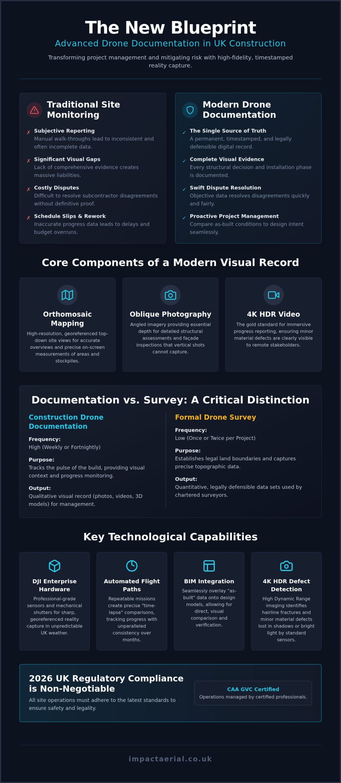
Professional construction drone documentation is the systematic, recurring capture of aerial data to establish a permanent, timestamped record of site progress. In 2026, the industry has moved decisively beyond simple aerial photography. We now operate in an era of reality capture, where high-resolution sensors, photogrammetry, and LiDAR create precise digital replicas of physical assets. This transition allows project managers to interrogate a site remotely with a level of detail that traditional ground-based inspections simply cannot match. It’s no longer about taking a few “snaps” for a newsletter; it’s about generating a legally defensible dataset.
Relying on manual site walk-throughs often results in subjective reporting and significant visual gaps. These gaps become massive liabilities when disputes arise or when adhering to the “Golden Thread” of information required by UK building safety regulations. By maintaining a continuous digital record, firms ensure that every structural decision and installation phase is documented with indisputable visual evidence. This level of transparency is essential for modern drone applications in construction, where data integrity is just as important as the physical build itself.
The Core Components of a Visual Record
- Orthomosaic mapping: These high-resolution, georeferenced top-down views allow for accurate site overviews and precise on-screen measurements of areas or stockpiles.
- Oblique photography: By capturing images at an angle, we provide the depth needed for structural assessments and detailed façade inspections that vertical shots miss.
- 4K HDR video: This is the gold standard for immersive progress reporting and stakeholder presentations, ensuring that even minor material defects are visible to the remote eye.
Documentation vs. Traditional Surveying
It’s vital to distinguish between routine construction drone documentation and a formal drone survey. While documentation supports surveying by providing context and visual proof, it doesn’t replace the legal land boundaries established by a chartered surveyor. The primary difference lies in the factor of frequency. A topographic survey might happen once or twice during a project’s lifecycle, whereas documentation typically occurs weekly or fortnightly to track the pulse of the build. Visual records provide the qualitative context that breathes life into quantitative technical data sets, creating a holistic view of the site’s evolution.
Technical Capabilities: From 4K HDR Visuals to 3D Site Models
High-tier hardware is the foundation of reliable construction drone documentation. We utilize DJI Enterprise grade hardware because it provides the sensor size and mechanical shutter capabilities required for professional-grade reality capture. These systems offer the flight stability needed to operate in the unpredictable UK climate, ensuring that every frame is sharp and georeferenced. The inclusion of 4K HDR (High Dynamic Range) is not merely an aesthetic choice. It is a technical necessity for identifying hairline fractures in concrete or minor material defects that standard sensors might blow out in bright sunlight or lose in deep shadows.
This data integrates seamlessly with Building Information Modelling (BIM) workflows, allowing for a direct comparison between the “as-built” conditions and the original design intent. Raw data is useless without context. Our post-production services transform gigabytes of visual information into actionable PDF reports and interactive models. By processing raw files into structured datasets, we provide project teams with a clear, visual audit trail that supports every stage of the construction lifecycle.
High-Resolution Progress Monitoring
Consistency is key for effective oversight. We establish repeatable, automated flight paths to create precise “time-lapse” comparisons over months of construction. While these missions are primarily technical, they can also utilize aerial filming drone techniques to produce cinematic content for high-level stakeholder reviews. Additionally, thermal sensors allow us to document the integrity of insulation and HVAC systems before they are sealed behind cladding, identifying heat loss or moisture ingress early in the build.
3D Reality Capture and Digital Twins
Beyond 2D images, we use photogrammetry to convert aerial captures into high-density 3D point clouds and digital twins. This allows site managers to measure volumes of earthwork or stockpile sizes directly from their desks with high precision. For off-site stakeholders, professional virtual tour creation provides 360-degree site access. This means a project director based in London can inspect a Birmingham jobsite in granular detail without the time or safety risks of a physical visit. These advancements in digital twins and sustainable construction are frequently explored at global forums like Construction Technology ConFeX KSA. If you require a technologically adept partner to manage your site’s digital record, consult with our specialist team to discuss your project requirements.
Strategic Risk Management and ROI Analysis
Strategic implementation of construction drone documentation acts as a visual insurance policy for modern infrastructure projects. By maintaining a georeferenced, timestamped archive of every site development, project managers can settle subcontractor disputes with indisputable evidence. Instead of relying on conflicting site diaries or subjective memory, you have a single source of truth to verify exactly when a specific task was completed or when a material delivery arrived. This transparency mitigates the risk of “he-said-she-said” conflicts that often lead to costly legal delays and fractured professional relationships.
Beyond legal protection, aerial oversight fundamentally enhances site safety. Drones identify potential hazards, such as perimeter breaches or unsecured materials on high-level floors, before they lead to reportable incidents. This proactive approach significantly reduces the need for high-risk manual inspections. For instance, using drones to inspect a roof or a tower crane eliminates the requirement for scaffolding or cherry pickers. This directly lowers the site’s overall risk profile and associated operational costs while keeping your team on the ground and out of harm’s way.
In the UK construction market, the presence of a rigorous visual audit trail can also influence insurance negotiations. Insurers increasingly recognize that firms utilizing construction drone documentation are better equipped to defend against fraudulent claims and prove compliance with strict safety protocols. This level of meticulous record-keeping provides the reassurance that underwriters look for, which may lead to more favourable commercial premiums over the project’s lifecycle.
Reducing On-Site Footfall and Hazards
Professional drone services minimize the necessity for staff to enter ‘red zones’ or high-traffic areas during peak operational hours. By providing remote site oversight, project directors can conduct virtual inspections from a central office, reducing on-site footfall without sacrificing granular detail. We’ve seen instances where high-resolution aerial captures spotted a structural anomaly, such as a misaligned steel connection, during the early assembly phase. Identifying this issue from the air saved the client thousands of pounds in potential rework and prevented a significant schedule slip.
The ROI of Professional Data Collection
The financial argument for a managed drone service is clear when compared to the compounding costs of project delays. Traditional surveying or manual inspections often take days to coordinate and execute; however, aerial data is typically processed and delivered within hours. This rapid turnaround allows for real-time decision-making that keeps the critical path on track. Comprehensive aerial documentation prevents ‘hidden’ costs during the project closeout phase by providing an indisputable ‘as-built’ record that simplifies the handover process to the client or facility manager.
Establishing a Compliant Documentation Workflow on UK Sites
Operating a drone on a live UK construction site in 2026 requires more than just technical skill; it demands total adherence to the Civil Aviation Authority (CAA) regulatory framework. For any commercial project, hiring a pilot with a General Visual Line of Sight Certificate (GVC) is a legal necessity. This certification ensures the operator understands the complexities of the 2026 drone classifications and the mandatory Remote ID requirements for UK1, UK2, and UK3 class drones. When your project is located in a congested urban area, these qualifications become even more critical to ensure the safety of the public and site personnel.
Insurance is another non-negotiable pillar of a professional construction drone documentation strategy. While the law requires third-party liability for commercial drones, the industry standard for major UK infrastructure projects is £5m commercial liability insurance. This level of coverage provides the necessary reassurance for tier-one contractors and stakeholders. Additionally, data privacy remains a priority. Professional operators must implement strict GDPR protocols to ensure that the privacy of site workers and neighbouring properties is respected during the reality capture process, typically by blurring faces or sensitive off-site information during post-production.
Pre-Flight and Site Integration
Success begins before the drone leaves the ground. We develop site-specific Risk Assessments and Method Statements (RAMS) that integrate with your existing health and safety documentation. This includes coordinating with site managers to establish flight windows that don’t interfere with crane movements or critical deliveries. For projects requiring sub-centimetre accuracy, we establish Ground Control Points (GCPs) across the site. These physical markers act as anchors, ensuring that the digital record aligns perfectly with real-world coordinates and your BIM software.
The 5-Step Documentation Cycle
To maintain a robust visual audit trail, we follow a methodical five-step cycle:
- Step 1: Define capture frequency based on critical project milestones, such as foundation pours or structural topping out.
- Step 2: Execute automated flight paths to ensure data is repeatable and consistent for time-lapse comparisons.
- Step 3: Upload and process raw data into high-density 3D models or 2D orthomosaic maps.
- Step 4: Distribute detailed progress reports to stakeholders via secure cloud platforms.
- Step 5: Archive the visual record as a permanent ‘as-built’ reference for the building’s lifecycle.
Implementing a compliant workflow protects your project from both legal liability and operational delays. If you need an expert partner to handle the complexities of CAA regulations and site safety, contact Impact Aerial today to secure professional construction drone documentation for your next project.
Impact Aerial: Professional Documentation for the UK Construction Sector
Impact Aerial provides a specialized suite of services tailored to the rigorous demands of the UK built environment. While our operations are headquartered in Birmingham, we provide comprehensive national coverage for projects ranging from local residential developments to high-value national infrastructure. Our approach to construction drone documentation is centered on technical precision and regulatory excellence. We don’t just capture images; we manage the entire data lifecycle to ensure your project has a definitive visual record.
Safety and compliance are the foundations of our service. We maintain a current drone license and strictly adhere to the latest CAA GVC standards. With £5m commercial liability insurance as standard, we provide the legal and financial reassurance that tier-one contractors and stakeholders require. Our expert post-production team then transforms raw aerial data into professional assets suitable for both internal jobsite management and high-end stakeholder marketing.
Why Partner with a Managed Service Provider?
Establishing an in-house drone program often presents a significant administrative and financial burden. Partnering with a managed service provider removes the weight of hardware maintenance and pilot training from your internal team. You gain immediate access to the latest DJI Enterprise technology without the capital expenditure or the need to monitor evolving aviation laws. Reliability is a core benefit; professional pilots ensure that construction drone documentation is captured consistently, regardless of the internal site pressures or competing priorities that often sideline in-house efforts.
Get Started with Your Site Record
Every project has unique documentation requirements based on its scale and complexity. We begin every partnership with a consultation to map your project’s specific needs, whether you require weekly progress overviews or milestone-based visits for critical structural phases. Our scheduling remains flexible, adapting to your site’s timeline to ensure no development goes unrecorded. This methodical approach ensures that your “as-built” record is complete, georeferenced, and ready for handover. Contact Impact Aerial to secure your construction site monitoring partner today and establish a single source of truth for your project.
Securing the Future of Your Project Site
Adopting professional construction drone documentation is no longer a choice between technology and tradition; it’s a strategic move toward evidence-based project management. You’ve seen how reality capture provides a definitive single source of truth that settles disputes, improves stakeholder communication, and mitigates on-site risks. By integrating high-resolution 4K HDR visuals with precise BIM-ready data, your team can identify structural anomalies and material defects before they impact the critical path or your project’s bottom line.
Impact Aerial provides the technical expertise and regulatory reassurance needed to maintain a compliant digital record. With our Birmingham-based team of CAA GVC certified pilots and £5m commercial liability insurance, we offer a managed service that scales across the entire UK. We handle the complexities of hardware maintenance and aviation compliance so you can focus on delivering high-quality infrastructure. Take the next step in streamlining your site monitoring and risk management strategy today. Request a Professional Drone Documentation Quote and ensure your project remains on schedule and fully documented for its entire lifecycle.
Frequently Asked Questions
Is a special license required for drones on UK construction sites?
Yes, commercial drone operations on UK jobsites require specific certifications from the Civil Aviation Authority. Our pilots hold the CAA GVC (General Visual Line of Sight Certificate), which is the standard for professional construction drone documentation in 2026. This ensures every flight adheres to strict safety protocols and legal requirements. We also maintain £5m commercial liability insurance to protect all stakeholders during our operations.
How often should we document our construction site with drones?
The ideal frequency depends on your project’s pace and complexity. Many of our clients opt for weekly or bi-weekly visits to capture consistent progress data for stakeholder reporting. Alternatively, you can schedule visits around critical milestones, such as foundation pours or structural completion. Regular construction drone documentation creates a robust visual audit trail that is invaluable for resolving potential subcontractor disputes or scheduling delays.
Can drone documentation integrate with our existing BIM software?
High-quality aerial data is designed for seamless integration with Building Information Modelling (BIM) workflows. We provide georeferenced orthomosaics and 3D point clouds that plug directly into platforms like Autodesk Revit. This allows site managers to overlay “as-built” reality capture data against original design models. It’s an efficient way to spot deviations early, ensuring the project remains compliant with the initial structural specifications and safety standards.
What happens if the weather is poor on the scheduled flight day?
Safety is our primary concern, so we don’t fly in heavy rain or high winds that exceed our hardware’s operational limits. We monitor local weather forecasts leading up to your scheduled visit. If conditions are unsuitable, we coordinate with your site manager to reschedule for the next available clear window. This flexibility ensures we always capture high-quality, stable 4K HDR footage without compromising on-site safety or data integrity.
Does drone documentation replace traditional land surveying?
Aerial documentation is a powerful tool for progress monitoring, but it doesn’t replace the legal role of a chartered land surveyor. While our drones provide highly accurate volumetric data and topographic overviews, they complement the formal boundary markers and legal records established by traditional surveying. Think of drone data as the “visual layer” that adds real-time context to your project’s quantitative technical datasets, creating a more comprehensive site record.
How secure is the aerial data once it has been captured?
We treat your site data with the same level of security as any sensitive commercial asset. Once captured, raw files are processed and stored on secure, encrypted cloud platforms with restricted access for authorized stakeholders only. We also strictly follow UK GDPR regulations. This includes ensuring that the privacy of neighbouring properties and site workers is protected through careful flight planning and meticulous post-production editing to blur sensitive information.
What is the typical turnaround time for a site progress report?
Efficiency is a hallmark of our managed service. Standard visual progress reports and 4K HDR videos are typically delivered within 24 to 48 hours of the flight. If your project requires complex 3D reality capture or detailed photogrammetry processing, the turnaround might extend slightly depending on the data volume. To ensure your team has the bandwidth to download and review these large datasets without delay, you can learn more about high-speed connectivity solutions. We prioritize rapid delivery so your team can make informed, data-driven decisions without waiting days for processed results.
While not always a strict legal requirement if we’re operating within CAA safety distances, we strongly recommend informing neighbouring properties as a courtesy. Good community relations are vital for any major UK construction project. Our team can provide technical details about our flight paths and safety protocols to help reassure residents. We also use post-production techniques to ensure that off-site privacy is maintained throughout the documentation process.
 2 Norton Drive, Wythall, Birmingham, B47 6HH Company registration number: 11138586. VAT Number: 366 9068 55


