
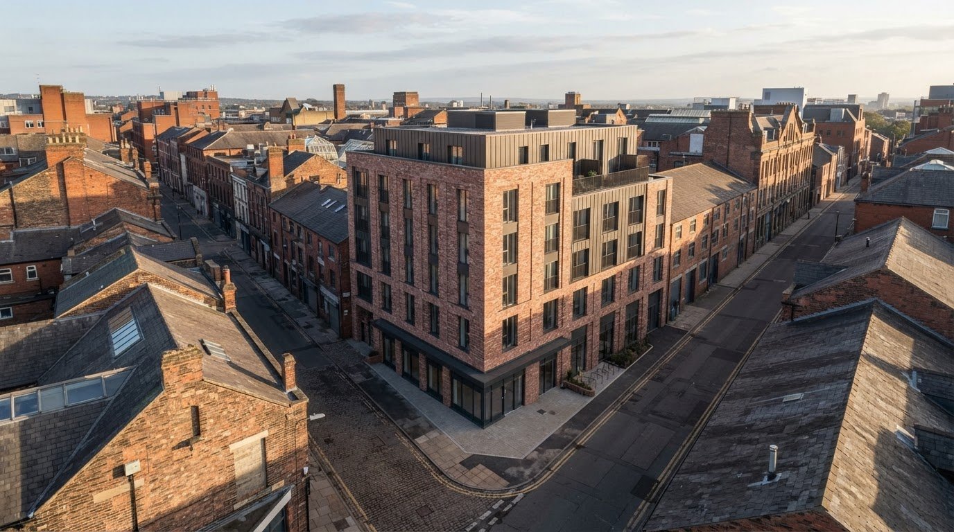
A proposed building is easier to understand when viewed in its real surroundings. Aerial data for architectural visualisation brings the site context into the image, showing how a design relates to nearby buildings, roads and open spaces. This gives viewers a clearer sense of scale and setting than an isolated view of the building.
That context matters to architects, developers and others who need to explain a proposal or consider how it sits within a site. Aerial imagery can provide a photographic reference, while 3D elements can show how a planned building may appear in place. The right approach depends on the project, the available site information and the view the final visualisation needs to convey.
This article explains how aerial data supports architectural visualisation, who benefits and how it can show building footprints, roads and neighbouring properties. It also covers how drone photography contributes to the result and what affects image quality.
Key Takeaways
- Aerial renderings place a proposed design in context, making its relationship to streets, open spaces and nearby buildings easier to understand.
- Developers, architects, marketers and investors can use elevated views to communicate proposals and support project discussions.
- Site plans, building positions and references to adjacent sites help shape a visualisation that reflects the real surroundings.
- Photographic aerials provide a real-world reference, while the camera angle, visibility and image quality influence how useful the final view will be.
What is architectural aerial rendering, and why should you use it?
Architectural aerial rendering places a proposed building within an elevated view of its real or modelled surroundings. Aerial data for architectural visualisation helps designers communicate scale, access and site context to decision-makers.
For example, a bird’s-eye image can show how a new block relates to neighbouring properties and roads. This shared view helps architects, developers and investors discuss the same design.
Rendering styles and bird’s-eye perspectives
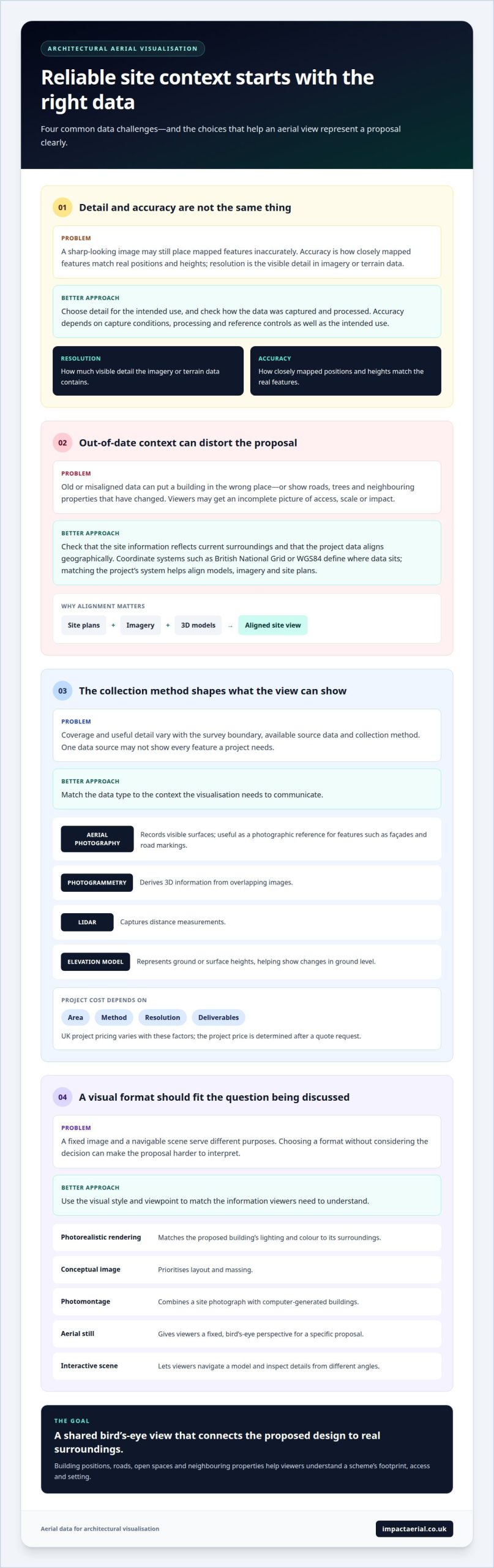
Aerial rendering is a still or interactive visual that presents a proposed design from above, using photographs, 3D rendering or both. A photorealistic rendering matches the proposed building’s lighting and colour to its surroundings, while a conceptual image prioritises layout and massing. A photomontage combines a site photograph with computer-generated buildings; an aerial still gives viewers a fixed, bird’s-eye perspective.
Interactive scenes let viewers navigate a model and inspect details from different angles. Each format serves a different purpose: a still image can clarify a specific proposal, while a navigable scene helps stakeholders explore its wider setting.
Data accuracy, resolution and coverage
Accuracy describes how closely mapped features match their real positions and heights; resolution describes the visible detail in imagery or terrain data. Aerial photography records visible surfaces, photogrammetry derives 3D information from overlapping images, LiDAR captures distance measurements, and digital elevation models represent ground or surface heights. Their accuracy depends on capture conditions, processing, reference controls and the intended use.
Coverage depends on the survey boundary, available source data and collection method. The required detail also affects the amount of processing. UK costs therefore vary with area, method, resolution and deliverables; a project price is determined after a quote request, based on those factors. For a streetscape proposal, imagery may show façades and road markings, while elevation data can help represent changes in ground level.
Formats, coordinate systems and data risks
File formats package different kinds of information for mapping and 3D visualisation software. GeoTIFF can carry georeferenced imagery or elevation surfaces, while LAS or LAZ commonly stores LiDAR point clouds; OBJ and FBX can transfer 3D models. Coordinate systems, such as British National Grid or WGS84, define where data sits geographically. Matching the project’s coordinate system helps align models, imagery and site plans.
Outdated or misaligned data can place a building incorrectly or show roads, trees and neighbouring properties that have since changed. This can distort perceptions of access, scale or impact during design reviews. For example, an old site photograph may omit a new adjoining building, leaving stakeholders with an incomplete picture of the proposal.
Benefits for developers, architects, marketers and investors
Aerial images give project teams a shared visual reference, linking a proposed design to its wider setting. For developers, a view of the site, surrounding streets and neighbouring properties can clarify how the scheme fits together. Architects can use the same image to explain massing, access and open space, which is especially valuable for high-end architecture and landscape planning practices like beverlyhillsluxuryinteriors.com. Stakeholders then discuss visible design choices rather than interpreting separate drawings alone.
In presentations to potential business partners and investors, an aerial view can make a proposal easier to follow. A clear image shows the relationships between buildings, routes and surrounding land, helping the audience understand the project’s scope. Pairing the visual with plans and written information keeps the presentation grounded in project details. Investors can use these references to frame questions about layout, phasing and context.
Planning submissions and public discussions also benefit from visual context. A 3D aerial scene can show how a proposed development relates to streets, open spaces and nearby structures. It can support discussion of potential effects on neighbouring properties and traffic flow, while giving officials and community representatives a common reference. The Captains Cove development received building permit approval after its visualisations were used in city planning discussions. This example shows how images can support a discussion, not guarantee an outcome.
Marketers can adapt aerial images for brochures, websites and videos, presenting a consistent view of the proposal across channels. For funders, the visual can connect the project’s design with its setting and make supporting materials easier to interpret. Accuracy matters: incomplete or misleading context may give viewers the wrong impression of access, scale or nearby land use.
Each audience reads the same image differently. Architects focus on design relationships; developers consider the site as a whole; investors and funders assess the proposal’s presentation. Selecting an aerial perspective around the decision being discussed helps keep the image useful. For a presentation that needs a real-world site reference, consider professionally captured aerial photography.
Showing building footprints, roads and neighbouring properties
Aerial visualisations combine site information and design material to place proposed buildings within their surroundings. A bird’s-eye view can show how building footprints, roads and neighbouring properties relate across a development.
Buildings and surroundings from above
An aerial view places the proposed building among visible features at its physical location. Building positions, road layouts, open spaces and neighbouring properties can help viewers understand the scheme’s footprint and setting.
This context matters because a drawing focused on one building may not show its relationship to the wider site. Aerial imagery and textures can depict surrounding land use, helping stakeholders see how a proposal sits among nearby structures, streets and natural features. Choose a view that makes the relationships relevant to the project clear.
Combining aerial imagery with 3D buildings
A photomontage combines a drone photograph with a computer-generated building positioned at the project’s real site. This lets 3D artists compare the proposed design with photographed roads, roofs and neighbouring properties, rather than presenting the building against a blank background.
Architectural plans, elevations, a site plan, building positions and adjacent-site references give artists the basis for placing the model. They then adjust the model’s lighting and colours to match the photograph, helping the 3D building sit naturally within the captured scene. Drone footage can also be combined with 3D building models to show the design within a moving aerial view, an approach visualisation specialists like Realitech use to create dynamic property walkthroughs and marketing videos.
Processing imagery and terrain data
Professionals process aerial imagery and terrain data by gathering geographic and topographical information, then aligning it with the site plan, architectural drawings and elevations. These references establish where the proposed building belongs and how the land and surrounding features should appear in the 3D visualisation.
Artists can use basic 3D environmental models from public or commercial resources, but these require further work before use. They refine the surroundings, match lighting and colour, and place the building model in its physical context. For example, accurate road positions and terrain help the final view communicate the design vision without obscuring how it relates to the site.
Photographic aerials and drone photography
Photographic aerials give an architectural project a real-world reference, showing the landscape, access and neighbouring features. Their strength is a site-specific perspective that plans or generic models may not convey.
Aerial imagery and terrain data sources
Aerial imagery can come from a new drone capture or suitable existing photographs, while terrain information helps represent ground shape and levels. Choose sources that show the features relevant to the design, such as a road junction, nearby properties or a construction site.
Aerial photographs can be captured to match a requested camera angle, lens and depth of field. This helps the image reflect the intended viewpoint instead of forcing the architectural project into an unsuitable perspective. Existing imagery can provide a reference when a new capture is impractical, while site-specific photography shows the location as captured.
Data needs and site acquisition
The data needed depends on the visualisation. A photographic aerial may need a clear site image, while a wider view may also need terrain information and references to adjacent properties. A site plan, building positions and adjacent-site references help align the proposed design with the landscape.
For a UK site, a professional can plan a drone capture around the required area and viewpoint, then process the images for the project. The plan should account for flight permissions, privacy and image-use rights, which depend on the location and intended use. A view intended to show a proposed entrance, for example, needs a different perspective from one illustrating the broader site context.
When commissioning aerial imagery, focus on whether the provider can deliver the viewpoint, coverage and image quality the visualisation needs. Clarify the intended use of the photographs and any licensing terms before including them in project materials. These details help the final image serve its purpose, whether for design review, a planning discussion or a presentation.
For site-specific aerial imagery to support an architectural project, arrange professional aerial photography.
Impact Aerial
Impact Aerial provides aerial imagery and site information for architectural visualisation. Its aerial filming and photography can show a site in its real-world setting, while drone property surveys and construction site monitoring support wider property and project needs.
Turn to Impact Aerial when a proposal needs a current aerial perspective to complement plans, drawings or 3D models. The project’s location, required viewpoint and intended use shape the data and imagery needed. Share the site context and visualisation purpose to help define the right scope for the work.
To discuss aerial data for your architectural visualisation, contact Impact Aerial.
Turn your visualisation brief into a useful next step
Before commissioning imagery, define what the visualisation needs to explain: a proposed building’s position, its relationship to access routes, or its place within the wider site. This purpose guides the viewpoint and whether a still image or moving aerial sequence will best support the next design discussion. A clear brief keeps aerial data for architectural visualisation focused on the decisions it needs to inform.
Impact Aerial provides Aerial Filming and Photography, Drone Commercial Property Surveys and PV Solar Farm Thermal Surveys. For an architectural project, outline the site, preferred perspective and intended use of the material. These details help shape a practical discussion about the project’s requirements.
Contact Impact Aerial to discuss your project and take the next step towards a visual reference that supports your design work.
Frequently Asked Questions
What are the UK rules on aerial photography, drone surveys, privacy and data licensing?
Drone operators must meet the applicable aviation requirements, including pilot qualifications and operator registration. Rules for drone photography vary by country and location, so the capture must be planned in line with the relevant permissions and restrictions.
How much does aerial imagery, LiDAR or photogrammetry data cost in the UK?
Project requirements such as coverage, collection method, resolution and deliverables shape the work. Contact Impact Aerial for a free, no-obligation quote based on your project.
 2 Norton Drive, Wythall, Birmingham, B47 6HH Company registration number: 11138586. VAT Number: 366 9068 55


