

What if the most significant threat to your project’s handover isn’t a supply chain delay, but the invisible discrepancies hiding within your completed structure? For UK Tier 1 contractors and project managers, the traditional reliance on manual tape measures and visual inspections often leads to inaccurate documentation that haunts the building’s lifecycle. Deploying as-built surveys with drones has shifted from a high-tech luxury to a commercial necessity. These surveys provide a meticulous, high-precision record of the site as it actually exists, rather than how it was originally envisioned on a CAD screen.
You likely recognise that traditional site verification is too slow, often dangerous, and prone to human error. This professional guide explains how drone-based site audits bridge the gap between design intent and physical reality, ensuring your digital twin is a true reflection of the asset. You’ll discover how to integrate high-precision data into your BIM workflow, reduce long-term liability through robust documentation, and accelerate the handover process. We’ll explore the technical standards, CAA compliance requirements, and hardware capabilities defining the industry in 2026.
Key Takeaways
- Understand the technical distinction between raw data capture and final CAD/BIM drawings to ensure your project documentation is legally robust.
- Learn how to select the optimal sensor technology by comparing the high-resolution visual outputs of Photogrammetry with the structural precision of LiDAR.
- Discover how as-built surveys with drones can reduce on-site data collection time by up to 75% while removing personnel from hazardous environments.
- Identify the specific deliverables, such as 3D point clouds and orthomosaic maps, required to create a verified digital twin of your completed asset.
- Recognise the essential UK compliance standards, including CAA GVC certification and commercial insurance, necessary for professional site verification.
What is an As-Built Survey with Drones?
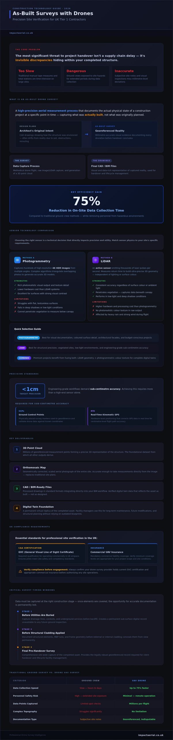
An as-built survey with drones is a high-precision aerial measurement process designed to document the actual physical state of a construction project at a specific point in time. While design plans represent the architect’s original intent, the as-built survey captures the reality of what has been constructed. It’s essential to understand the technical distinction between the survey and the final as-built drawings. The survey is the methodical process of data capture and point cloud generation. The drawings are the resulting CAD or BIM files that provide a visual and data-rich representation of that captured reality.
Timing plays a vital role in the success of these surveys. Professional drone teams typically capture data during critical windows, such as immediately before utilities are buried or structural elements are covered by cladding. This creates a permanent digital record of sub-surface assets that would otherwise be lost to visual inspection. This data forms the backbone of a Digital Twin. Facility managers rely on these virtual replicas for long-term operations, ensuring they have an accurate map for maintenance or future structural modifications without relying on potentially outdated blueprints.
Why Design Plans Rarely Match Reality
Site deviations are an inherent part of the construction process. Whether it’s a rerouted drainage line to avoid an unforeseen obstruction or a minor shift in grade levels due to soil conditions, the physical build often drifts from the initial design. Carrying this undocumented risk into subsequent construction phases or the final handover is a significant liability. Aerial data provides project stakeholders with an indisputable, georeferenced record of the site. It replaces subjective site notes with millimetre-accurate visual evidence, ensuring that every deviation is documented and accounted for before the project concludes.
The Evolution from Ground Crews to UAVs
Traditional ground surveys rely on total stations and manual measurements. While these tools are precise, the process is slow and often struggles with complex topographies or large-scale industrial environments. Ground crews are also exposed to site hazards for extended periods. Modern UAV technology has transformed this workflow. A professional survey drone can capture comprehensive site-wide data in a fraction of the time, generating millions of data points in a single flight. This speed doesn’t just save money; it provides a level of detail that manual spot-checks cannot replicate, delivering a complete picture of the asset’s integrity.
Photogrammetry vs. LiDAR: Choosing the Right Sensor for Site Verification
Selecting the appropriate sensor is a technical decision that directly impacts the precision and utility of your as-built surveys with drones. It’s not merely a choice of hardware; it’s about matching the physics of the sensor to the specific requirements of the construction site. For UK project managers, this choice usually sits between Photogrammetry and LiDAR (Light Detection and Ranging). Both technologies offer distinct advantages depending on whether you prioritise visual fidelity, structural detail, or the ability to penetrate environmental obstacles.
Photogrammetry involves capturing hundreds of high-resolution 4K HDR images from multiple angles. These images are then processed using complex algorithms to create 3D models through triangulation. This method relies heavily on visual contrast and consistent lighting to identify identical features across different frames. LiDAR, by contrast, is an active sensor that emits thousands of laser pulses per second. It measures the time taken for these pulses to return, allowing it to “see” through vegetation or capture highly accurate data in low-light conditions where traditional cameras would struggle.
Accuracy standards in engineering-grade workflows often demand sub-centimetre precision. Achieving this level of reliability requires more than just a high-end sensor; it necessitates the use of Ground Control Points (GCPs) and RTK-enabled hardware. Environmental factors like wind, rain, and extreme shadows play a decisive role in sensor selection. Photogrammetry often fails in areas with flat, textureless surfaces or deep shadows, whereas LiDAR remains consistent regardless of surface colour or ambient light levels. If you’re unsure which technology fits your project requirements, our technical consultants can advise on the most effective drone survey strategy for your specific site.
When to Use Photogrammetry
Photogrammetry remains the industry standard for generating high-detail visual orthomosaics and general site progress monitoring. It’s particularly cost-effective for large-scale earthworks and grading projects where visual context is as important as the topographic data itself. Photogrammetry’s accuracy depends on the software’s ability to identify identical features across multiple images with significant overlap for precise 3D reconstruction.
When LiDAR is Essential
LiDAR is indispensable when mapping sites with significant tree canopies or complex scaffolding that requires high-accuracy vertical measurements. Its active pulses can penetrate gaps in vegetation to map the underlying ground surface, making it the superior choice for complex industrial environments. It’s also the only viable option for mapping thin, linear features like power lines or complex structural steelwork that photogrammetry might fail to resolve accurately.
The Business Case: Comparing Drone-Based Surveys to Traditional Methods
The transition to as-built surveys with drones represents a fundamental shift in construction economics. Traditional surveying often requires days of manual data collection, involving multiple technicians and expensive equipment hire. By contrast, aerial surveys can reduce on-site data collection time by up to 75%, allowing projects to maintain momentum without the need for site closures or heavy plant downtime. This efficiency doesn’t just save time; it translates directly into cost savings by minimising the labour hours required to produce a comprehensive site record.
Data density is where the technical advantage becomes most apparent. A traditional total station survey typically captures hundreds of discrete points, leaving the surveyor to “connect the dots” and interpolate the areas in between. An as-built survey with drones generates millions of georeferenced data points, creating a dense point cloud that captures every structural nuance. This granular detail ensures that no element is overlooked, providing a level of site verification that manual methods simply cannot match. It’s a move from sparse sampling to total site documentation.
Eliminating Human Error in Data Collection
Manual measurements are inherently prone to human error, particularly on complex or high-elevation sites. Automated flight paths remove this subjectivity by ensuring repeatable, objective data capture across every survey mission. This consistency is vital for multi-phase projects where longitudinal data comparison is required. By capturing the site accurately the first time, contractors can significantly reduce the “re-work” costs associated with inaccurate manual measurements. You can explore our full range of drone services to see how these automated workflows integrate into your existing project management structure.
Enhanced Site Safety and Compliance
From Point Clouds to BIM: Understanding As-Built Deliverables
The raw data captured during as-built surveys with drones is processed into several high-value deliverables that serve different project stakeholders. Orthomosaic maps provide georeferenced, top-down views with millimetre precision, allowing site managers to overlay current progress onto original design plans. These maps offer a comprehensive visual record that traditional photography cannot match. 3D point clouds act as the geometric foundation for Building Information Modelling (BIM). These clouds consist of millions of individual data points that represent the physical structure, enabling architects to create accurate BIM objects that reflect the actual build rather than the original design intent.
For civil engineering and groundworks, Digital Terrain Models (DTM) are essential for verifying drainage grades and earthwork completion. These models strip away surface features to provide a clear view of the bare ground topography. Deviation maps provide the most direct value for quality assurance and risk mitigation. Deviation maps highlight construction errors in real-time by visually identifying where the physical build differs from the CAD design model. This immediate feedback allows for corrective action before errors are compounded in later construction stages, protecting the project timeline and budget.
BIM Integration and File Formats
Modern construction workflows require seamless data transfer between the field and the office. We export drone data into industry-standard formats including .LAS for dense point clouds, .OBJ for textured 3D models, and .DXF or .IFC for CAD and BIM software compatibility. This technical interoperability accelerates the creation of “As-Built” Revit models, providing a verified digital twin of the structure. Integrating aerial data directly into your BIM environment ensures that handover documentation is robust, accurate, and ready for the facility management phase of the building’s lifecycle. To further support your project’s data needs, you can explore Transactional fees for digital geospatial data downloads and environmental reports from CentremapsLive to ensure you have access to authoritative site-wide information.
Volume Calculations and Stockpile Audits
Accurate material management is critical for project profitability and environmental compliance. Drone-based volume calculations provide instant, precise audits of stockpiles and excavation pits without the need for manual measurements or site stoppages. This streamlines financial reporting and enables better material management on-site by providing objective metrics. You can see how drone survey data transforms site management by providing verifiable data for every cubic metre of material moved. If you require professional assistance in converting aerial data into BIM-ready files, contact our team to discuss our Post-Production Services for your next project.
Implementing As-Built Drone Surveys with Impact Aerial
Impact Aerial operates as a specialized technical consultant, moving beyond simple aerial photography to provide engineering-grade as-built surveys with drones. Based in our Birmingham hub, we provide comprehensive UK-wide coverage, ensuring that Tier 1 contractors and project managers have access to high-precision data regardless of their site’s location. Our methodical approach is designed for the complexities of the modern build environment. It begins with a rigorous pre-flight risk assessment and extends through a meticulous post-production phase where raw data is transformed into the BIM-ready deliverables discussed earlier. We don’t just capture images; we provide a verified record of your project’s physical reality.
Hardware choice is a fundamental component of our service quality. We exclusively utilize industry-leading 4K HDR drone hardware to ensure the highest possible data fidelity for every mission. These platforms are specifically engineered for the rigours of industrial environments, providing the stability and sensor precision required for millimetre-accurate site verification. By combining this high-end hardware with a structured, data-centric workflow, we deliver a level of reliability that supports the most demanding construction schedules and regulatory standards. This technical meticulousness ensures that every point cloud and orthomosaic we produce meets the aspirational standards expected by industry leaders.
UK Regulatory Compliance and Safety
The UK regulatory environment for UAV operations is rigorous and constantly evolving. Certification is non-negotiable for commercial projects, particularly on high-risk construction sites where safety is the primary concern. Our pilots are CAA GVC certified, demonstrating a high level of competency and strict adherence to national aviation protocols. You can read our guide on the drone license requirements to understand why these standards are essential for project compliance. Our £5m commercial liability insurance provides a layer of reassurance for your project and stakeholders, ensuring that all aerial operations are fully indemnified and risk-managed.
Get Started with Your As-Built Project
Integrating as-built surveys with drones into your 2026 project schedule begins with a detailed technical consultation. During this process, we define your specific accuracy requirements and identify the exact file formats needed for your BIM or CAD workflow. This proactive planning ensures that data capture is timed perfectly with your construction milestones, such as capturing sub-surface utilities before they are permanently covered. Contact Impact Aerial today for a professional as-built survey quote to ensure your project’s handover is supported by precise, compliant documentation.
Securing Your Project Lifecycle with High-Precision Data
The transition toward as-built surveys with drones marks a definitive move away from fragmented, manual data collection toward a unified digital reality. By capturing high-precision point clouds and georeferenced orthomosaics, you don’t just document a build; you create a robust, BIM-ready asset that protects your firm from long-term liability. This process bridges the gap between design intent and physical completion, ensuring every deviation is accounted for before the final handover.
Working with a DJI Enterprise partner ensures your data meets the highest engineering standards. Impact Aerial provides UK-wide coverage from our Birmingham hub, utilizing CAA GVC certified pilots and carrying £5m commercial liability insurance for your absolute peace of mind. We act as your technical consultant to translate complex aerial data into actionable site insights that drive project efficiency. Request a Professional Drone Survey Quote from Impact Aerial to secure your site documentation for 2026. Let’s bring absolute clarity to your next project handover.
Frequently Asked Questions
How accurate are drone as-built surveys compared to traditional methods?
Modern drones achieve sub-centimetre relative accuracy and 1cm to 3cm absolute accuracy when utilizing RTK-enabled hardware and Ground Control Points. This precision matches or exceeds traditional total station results for large-scale topographic mapping. While traditional tools capture discrete points, as-built surveys with drones generate millions of data points, providing a more comprehensive and dense representation of the physical structure.
Do I need to close my construction site during a drone survey?
Site closures are rarely required during professional aerial data capture. Drones operate at height, allowing ground-based construction activities to continue without interruption. Our pilots perform detailed risk assessments to ensure flight paths don’t cross directly over personnel. This non-intrusive approach maintains project momentum while capturing high-precision data, a significant advantage over manual surveys that often require clearing specific work areas.
What file formats will I receive for my BIM software?
We deliver data in industry-standard formats designed for seamless integration into your existing workflows. Common deliverables include .LAS or .LAZ point clouds, .OBJ 3D models, and .DXF or .DWG CAD files. We also provide .IFC files for direct Building Information Modelling (BIM) compatibility. These formats ensure your design team can immediately use the aerial data in software such as Revit, AutoCAD, or Civil 3D.
Is a drone survey legal on a UK construction site?
Drone operations are fully legal provided the operator complies with Civil Aviation Authority (CAA) regulations. Professional surveyors must hold a valid GVC or A2 CofC certification depending on the aircraft and environment. Impact Aerial pilots are CAA GVC certified, ensuring full compliance with UK aviation law. We also carry £5m commercial liability insurance, meeting the stringent safety and risk management requirements of UK Tier 1 contractors.
How much does a drone as-built survey cost?
The total investment depends on site size, environmental complexity, and the specific accuracy requirements of your project. While we don’t offer fixed pricing without a consultation, drone surveys are typically more cost-effective than manual methods for large or complex sites. The 75% reduction in data collection time significantly lowers labour costs and removes the need for expensive access equipment like scaffolding or cherry pickers.
Can drones capture as-built data inside buildings?
Drones can capture internal as-built data using specialized sensors and indoor flight technology. While outdoor missions rely on GPS, indoor surveys use collision-avoidance systems and SLAM (Simultaneous Localization and Mapping) to navigate confined spaces. This allows us to document structural elements, MEP services, and internal finishes in complex environments where traditional line-of-sight measurement tools might struggle to provide a complete 3D record.
What is the difference between an as-built survey and an inspection?
A survey focuses on spatial measurement and georeferenced positioning, while an inspection prioritises visual condition and defect identification. As-built surveys with drones create precise 3D models and maps used for engineering verification and BIM integration. Inspections typically produce high-resolution imagery or thermal data to assess the integrity of assets like roofs or solar panels without necessarily requiring millimetre-accurate coordinate data for every point.
How long does it take to process the drone data into a 3D model?
Data processing typically takes between 24 and 72 hours depending on the project’s scale. The timeline is dictated by the number of high-resolution images captured and the complexity of the required 3D model. We use high-performance post-production software to clean, georeference, and convert raw data into your specified file formats. This ensures you receive a verified digital twin shortly after the flight mission is complete.
 2 Norton Drive, Wythall, Birmingham, B47 6HH Company registration number: 11138586. VAT Number: 366 9068 55


