
A single high-resolution photograph can show you a building, but it cannot explain how that building sits within its environment or how a complex site functions as a whole. Digital first impressions are now the industry standard, yet relying on static imagery often leaves a critical gap in spatial understanding for stakeholders and potential buyers. You likely recognize that traditional ground-level tours, while useful, often fail to provide the comprehensive context required for large-scale property marketing or technical site inspections.
By utilizing professional drone virtual tour services uk, you can bridge this gap with an immersive 360-degree digital twin that offers both granular detail and aerial perspective. This guide explores how these high-definition experiences transform property data into a powerful marketing and diagnostic asset. We’ll examine the technical advantages of aerial capture, the importance of maintaining full compliance with the latest 2026 CAA regulations, and how a Birmingham-based specialist with UK-wide coverage ensures your project is delivered with the precision and safety your business demands.
Key Takeaways
- Understand how interactive 360° environments surpass traditional photography by providing a complete, navigable digital representation of complex architecture and landscapes.
- Learn how FPV drone technology and 4K HDR sensors facilitate seamless transitions between internal and external spaces, even in challenging UK weather conditions.
- Compare the strategic advantages of aerial perspectives over ground-based tours for high-level asset management, such as roof inspections and estate mapping.
- Identify the mandatory safety standards and professional credentials, including CAA GVC certification and £5m liability insurance, required to secure compliant drone virtual tour services uk.
- Gain insight into the technical workflow of a professional provider, from initial site consultation to high-end post-production using enterprise-grade hardware.
What Are Drone Virtual Tour Services in the UK?
Drone virtual tour services in the UK represent a significant technological leap in how we visualize and interact with physical spaces. Unlike traditional photography, these services use Unmanned Aerial Vehicles (UAVs) equipped with specialized 360-degree cameras to capture entire environments from unique elevations. This creates an immersive, interactive experience where the viewer isn’t just looking at a picture, but is virtually standing within the scene. In 2026, UK businesses are increasingly moving away from static media toward these “fly-through” experiences to provide a higher level of transparency and engagement for stakeholders.
The evolution from simple aerial snapshots to fully interactive walkthroughs has been driven by rapid improvements in sensor technology and processing power. Today, luxury real estate developers, construction managers, and industrial site operators use these tours to provide a comprehensive view that ground-based cameras simply cannot reach. By combining high-altitude perspectives with the ability to “teleport” between different points of interest, these services offer a unique marketing and operational tool that bridges the gap between a simple map and a physical site visit.
To better understand how this technology creates a seamless flow through a property, watch this example of an aerial walkthrough:
The Difference Between Aerial 360s and Standard Drone Video
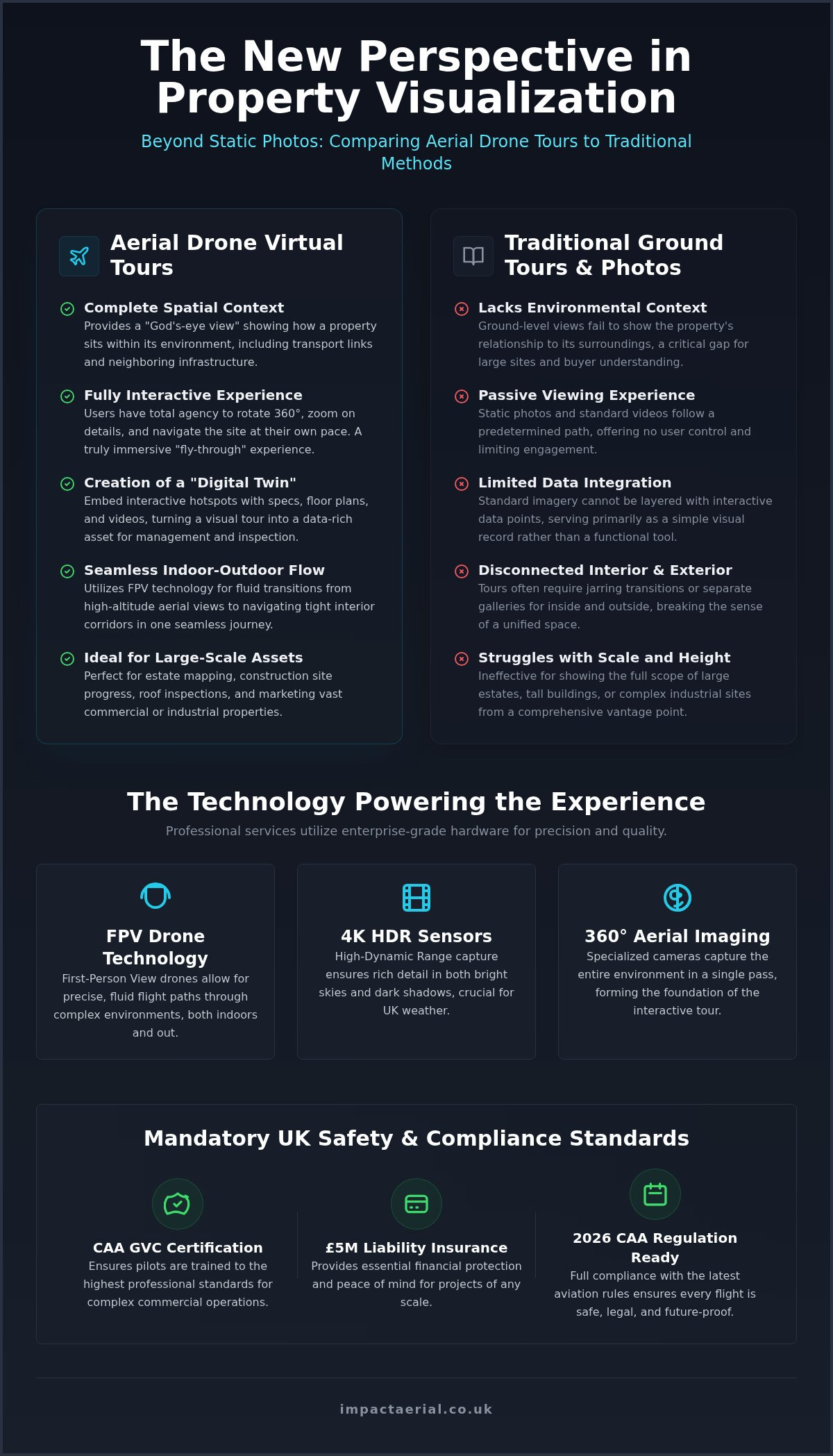
While standard drone video offers a cinematic perspective, it remains a passive experience. The viewer follows a predetermined path set by the pilot. In contrast, drone virtual tour services uk provide total user agency. Viewers can rotate their view 360 degrees, zoom in on specific architectural details, and navigate the site at their own pace. This interactivity is often enhanced by first-person view (FPV) technology, which allows for precise, fluid movement through tight spaces and interior corridors.
Data density is another key differentiator. Within a virtual tour, we can embed interactive “hotspots” that contain technical specifications, links to floor plans, or even secondary videos. This turns a visual asset into a Digital Twin, which is an accurate digital representation of a physical commercial asset used for long-term management and inspection. This level of detail is essential for complex industrial facilities where every component needs to be documented within its spatial context for maintenance or safety planning.
Why Aerial Perspective Matters for Large-Scale Sites
Traditional ground-based virtual tours are excellent for interior spaces but struggle with vast outdoor areas or tall structures. They lack the ability to show a building’s relationship to its wider environment, such as proximity to transport links or neighboring infrastructure. An aerial perspective solves this by providing a “god’s eye view” that ground tours cannot replicate. This is particularly valuable for estate mapping and large construction projects where site-wide context is as important as the building itself.
For those looking to integrate these assets into a broader operational strategy, it helps to understand the full scope of available technology. You can find more details in our complete guide to professional drone services. This comprehensive approach ensures that every angle of a site is captured with technical precision, providing a reliable foundation for both high-end marketing and detailed site inspections.
The Tech: FPV Drones and 360° Aerial Imaging
The technical foundation of professional drone virtual tour services uk relies on a sophisticated blend of specialized hardware and advanced post-production. To achieve a truly immersive experience, we utilize DJI Enterprise grade hardware capable of capturing 4K HDR data. This high-dynamic-range capability is essential for the UK’s varied weather conditions; it ensures that details aren’t lost in the shadows of a bright afternoon or washed out by the grey overcast skies common in the West Midlands. By capturing multiple exposures, we create a visual asset that maintains clarity across both the bright exterior landscape and the controlled lighting of an interior space.
Mastery of these tours extends beyond the flight itself into the technical stitching process. Creating a “no-seam” user experience requires precise alignment of multiple high-resolution images to form a spherical panorama. Once processed, these tours are optimized for cross-platform accessibility. Whether a stakeholder is viewing the site on a mobile device, a desktop browser, or through a VR headset for a fully immersive “on-site” feel, the technical integrity of the data remains consistent. If you are looking to integrate these technical assets into your next project, our team can provide a bespoke consultation to determine the best hardware configuration for your site.
FPV Drones: The ‘One-Shot’ Tour Revolution
Operating FPV equipment in confined commercial spaces requires rigorous safety protocols. Our pilots are CAA GVC certified and follow strict risk mitigation procedures to ensure safe operation indoors. We use specialized prop-guards and low-latency transmission systems to maintain total control, providing the reassurance that even the most complex flight paths are executed with professional precision and full insurance backing.
High-Resolution 360° Panoramas
While FPV drones provide movement, high-resolution 360° panoramas provide the “God’s eye view” necessary for site-wide navigation. By hovering a drone at strategic altitudes, we capture gigapixel-level detail that allows users to zoom into specific site features without losing image quality. These panoramas often serve as the main navigation menu for a virtual tour, allowing users to click on different areas of a site to “jump” to a detailed ground-level or interior view. This structural approach is a key component of cinematic aerial filming, where technical data and visual storytelling meet to provide a complete digital representation of a commercial asset.
Drone Tours vs. Traditional Ground-Based Virtual Tours
Ground-based virtual tours, often powered by systems like Matterport, have become the standard for internal property marketing. These systems offer high precision for room dimensions and interior aesthetics. However, they are fundamentally limited by their tripod-bound nature. For vast industrial sites, complex construction projects, or multi-acre estates, ground-based capture is inefficient and lacks the necessary elevation to demonstrate asset connectivity. Relying solely on ground-level data leaves a significant gap in the viewer’s understanding of how a building relates to its wider environment.
Professional drone virtual tour services uk provide the height and scale that ground-based tripods cannot replicate. While a ground tour of a 100,000 sq ft warehouse might require over 200 individual tripod setups, a drone can capture the entire external envelope and site layout from a few strategic aerial vantage points. This drastically reduces the time required on-site and provides a more cohesive navigation experience. The most effective digital assets now utilize a “Hybrid Tour” approach; they combine the granular interior detail of ground-level systems with the expansive aerial context provided by UAVs.
This hybrid methodology creates a seamless spatial bridge for the user. A stakeholder can inspect a roof’s condition from 20 meters up and then instantly “drop” into the internal office space at ground level. From a cost-benefit perspective, the efficiency of aerial capture for large-scale sites is unmatched. It replaces hundreds of manual tripod placements with a structured flight plan, delivering a complete digital twin in a fraction of the time.
When to Choose a Drone Virtual Tour
Aerial tours are the superior choice for construction site monitoring and managing large commercial property portfolios. They are particularly essential for drone surveys where height is a primary factor, such as inspecting high-level cladding or roof-mounted plant machinery. Beyond technical inspections, these tours are highly effective for tourism and luxury real estate, as they allow you to showcase local landmarks and geographic advantages that are invisible from the street.
Integrating Virtual Tours with Site Data
Modern virtual environments are no longer just visual marketing tools; they are functional data interfaces. We can overlay CAD drawings or site maps directly onto the aerial view, allowing project managers to compare “as-built” progress against original designs. These tours act as a visual front-end for survey drone data, providing a platform where users can measure distances, areas, and volumes directly within the 3D aerial environment. This integration of technical data with immersive visuals provides a level of site intelligence that traditional photography simply cannot match.
UK Safety, Compliance, and Insurance for Drone Tours
Hiring a provider for drone virtual tour services uk involves more than evaluating a visual portfolio. It requires a deep understanding of the legal framework governing UK airspace. For commercial operations, especially in congested urban areas or near sensitive infrastructure, the Pilot in Command must possess the appropriate qualifications. In 2026, the CAA GVC (General Visual Line of Sight Certificate) remains the professional benchmark for commercial work. This certification demonstrates that the operator has undergone rigorous theoretical and practical assessments; it ensures they can manage the risks associated with high-resolution aerial capture in complex environments.
Operating a drone for commercial gain without these credentials isn’t just a safety risk; it’s a legal liability for the hiring business. Beyond the pilot’s flying skill, professional drone virtual tour services uk must account for data protection. Privacy and GDPR compliance are vital when filming in residential or public areas. A compliant operator will have clear policies to ensure that any identifiable information captured during a 360-degree shoot is handled according to UK law. This meticulousness is what separates a technical specialist from a hobbyist with a camera.
Understanding CAA Regulations in 2026
The regulatory landscape for UAVs is precise and strictly enforced. Every flight must adhere to the specific requirements outlined in the UK drone license framework. This is not a mere administrative hurdle; it’s a critical safety protocol. Before any hardware leaves the ground, a professional operator will produce a comprehensive RAMS (Risk Assessment and Method Statement). This document identifies potential hazards, from physical obstacles to electromagnetic interference, and outlines the mitigation strategies used to keep the site and the public safe.
Operating in urban centers like Birmingham or near Flight Restriction Zones (FRZs) such as airports requires advanced planning. We frequently coordinate with local authorities and Air Traffic Control (ATC) to secure the necessary permissions for low-altitude filming. This structured approach ensures that your virtual tour is captured legally, preventing any potential fines or stop-work orders that could impact your project timeline.
Insurance and Liability: Protecting Your Business
Reliability in this industry is underpinned by comprehensive insurance. Standard hobbyist cover is fundamentally insufficient for commercial virtual tour services. Professional operators carry specialized commercial liability insurance that meets EC 785/2004 standards. At Impact Aerial, we maintain £5m in public liability coverage as a standard for all UK sites. This provides psychological comfort and tangible protection for our clients, ensuring that all parties are protected against unforeseen incidents during the capture process.
Verifying a pilot’s credentials before they arrive on-site is a vital step in your procurement process. You should always request proof of insurance and their CAA Operator ID. Our commitment to safety-first operations and technical compliance means we handle all the regulatory heavy lifting on your behalf. If you require a fully vetted and insured partner for your next project, you can book a compliant site assessment with our Birmingham-based team today.
Impact Aerial: Professional Virtual Tour Creation in the UK
Impact Aerial operates as a specialized technical consultancy for drone virtual tour services uk. We provide more than just aerial imagery; we manage the entire lifecycle of a digital twin project from inception to final delivery. Based in Birmingham, our central location serves as a strategic hub for efficient nationwide deployment. This allows us to provide consistent, high-tier service to construction sites, industrial facilities, and commercial property portfolios across the United Kingdom. Our team utilizes DJI Enterprise grade hardware exclusively, ensuring that every frame is captured in 4K HDR for superior visual clarity and data density.
Our end-to-end process is designed to provide professional reassurance at every stage. We begin with a detailed technical consultation to align our flight plans with your specific marketing or operational goals. Following this, our CAA GVC certified pilots handle all pre-flight logistics, including rigorous risk assessments and coordination with local authorities. Once the data is captured, our post-production specialists take over, meticulously stitching the aerial panoramas to create a fluid, high-definition user experience. This structured methodology ensures that your project is delivered on time, within budget, and in full compliance with all UK aviation regulations.
Custom Post-Production and Hosting
The value of a virtual tour lies in its ability to communicate information effectively. We provide bespoke post-production services that allow you to tailor the user interface to match your specific corporate branding. This isn’t a “one size fits all” solution; we integrate interactive hotspots that can trigger technical documents, secondary videos, or high-resolution floor plans. For commercial marketing tours, we can embed direct call-to-action buttons, such as “Book a Viewing” or “Contact Agent,” to streamline the user journey. To ensure these assets are easily accessible, we provide secure, high-speed hosting solutions that facilitate seamless embedding into your corporate website or internal stakeholder portals.
Start Your Aerial Project Today
Requesting a tailored quote for your property or site is a straightforward, transparent process. We take a consultation-led approach, taking the time to understand the unique challenges of your location—whether it’s an urban construction project in London or a vast industrial estate in the North. Our team will provide a comprehensive proposal that outlines the capture strategy, post-production requirements, and delivery timeline. This ensures total alignment before any hardware leaves the ground. Impact Aerial remains the trusted partner for UK businesses seeking a meticulous, compliant, and technologically adept specialist for their virtual tour requirements.
Elevate Your Property Marketing with Immersive Aerial Data
Adopting immersive aerial perspectives is now a strategic requirement for modern property stakeholders. By bridging the gap between ground-level detail and aerial context, these interactive experiences provide a comprehensive digital twin that enhances both marketing reach and site inspection accuracy. The integration of enterprise-grade DJI 4K HDR technology ensures that every architectural detail is preserved, providing a high-definition asset that serves your business long after the initial flight.
When selecting professional drone virtual tour services uk, technical competence and regulatory adherence are vital. Impact Aerial provides the reassurance of CAA GVC certified pilots and £5m commercial liability insurance, ensuring that every project is executed with meticulous precision and full legal compliance. We invite you to Request a Professional Drone Virtual Tour Quote from Impact Aerial today to begin transforming your site into a fully interactive digital experience. We look forward to helping you showcase your assets from a new perspective.
Frequently Asked Questions
What is a drone virtual tour and how does it differ from a normal video?
A drone virtual tour is an interactive 360-degree environment that gives the user total control over their perspective. Unlike a standard video, which is a passive experience with a fixed narrative, a virtual tour allows viewers to rotate their view, zoom in on specific details, and navigate through a site at their own pace. This interactivity makes it a superior tool for detailed site inspections and immersive property marketing.
Do I need special permission to have a drone fly around my commercial property?
You must grant permission as the landowner or manager for any drone operations on your site. Additionally, professional pilots must check for Flight Restriction Zones (FRZs) and coordinate with Air Traffic Control if the property is near an airport or sensitive infrastructure. Our CAA GVC certified pilots manage all these legal permissions and notifications as part of our comprehensive flight planning process to ensure full compliance.
Can drone virtual tours be integrated into my existing website or Matterport account?
Yes, these tours are designed for seamless cross-platform integration. We provide embed codes that work with most modern website builders and CMS platforms. While drone tours are distinct from ground-based Matterport scans, we can often link the two experiences. This creates a “hybrid tour” where users can transition from an aerial 360 view directly into a ground-level interior walkthrough for a complete digital twin experience.
Are drone virtual tours safe for indoor use in offices or warehouses?
Indoor flights are entirely safe when conducted by professionals using specialized hardware. We utilize compact FPV drones equipped with 360-degree prop guards to prevent damage to the aircraft or the building’s interior. Before any indoor flight, we conduct a rigorous site-specific risk assessment to identify obstacles and ensure the safety of any personnel on-site. This makes drone virtual tour services uk a viable option for large-scale internal facility tours.
How much does a professional drone virtual tour service cost in the UK?
The investment required for a professional tour depends on several technical factors, including the total acreage of the site, the number of required 360-capture points, and the complexity of the post-production. Each project is unique, so we provide bespoke quotes following a technical consultation. This ensures that the hardware configuration and data delivery are perfectly aligned with your specific operational goals and budget requirements.
What kind of insurance should a drone operator have for a virtual tour project?
A professional operator must hold specialist commercial drone insurance that complies with EC 785/2004. Standard hobbyist insurance is invalid for commercial virtual tour projects and leaves the client liable. Impact Aerial maintains £5m in public liability insurance as a standard for all UK operations. This provides essential protection and psychological comfort for our clients, ensuring that every project is backed by comprehensive corporate cover.
How long does it take to capture and produce a full aerial virtual tour?
A typical on-site capture session for a medium-sized commercial property is completed within one working day. The post-production phase, which involves stitching high-resolution images, embedding interactive hotspots, and configuring the hosting environment, generally takes between three to seven business days. We provide a clear timeline during the initial consultation so you can plan your marketing or project milestones with confidence and precision.
What weather conditions are required for a successful aerial 360 shoot?
Optimal results require dry conditions and wind speeds below 20mph to maintain aircraft stability and image sharpness. Good visibility is essential for capturing the high-dynamic-range detail expected from professional drone virtual tour services uk. While our enterprise-grade hardware can handle varied UK light conditions, we monitor meteorological data closely and will reschedule a shoot if the weather threatens the technical quality or safety of the operation.
 2 Norton Drive, Wythall, Birmingham, B47 6HH Company registration number: 11138586. VAT Number: 366 9068 55


