
Did you know that switching to a professional drone inspection for telecoms masts can reduce your operational costs by up to 80% compared to traditional rope-access methods? For years, the industry has relied on high-risk tower climbs and expensive cherry pickers to gather even basic structural data. You’ve likely felt the pressure of rising insurance premiums and the constant concern for health and safety liabilities every time a technician leaves the ground. It’s a logistical challenge that often results in incomplete data or blurred images from ground-based inspections.
We understand that maintaining network integrity while ensuring a zero-incident safety record is your primary objective. This 2026 industry guide will show you how to leverage the latest UK-compliant hardware and high-resolution sensors to transform your asset management strategy. You’ll learn how rapid deployment and meticulous data capture provide the superior visual evidence needed for proactive maintenance. We’ll also cover the critical 2026 CAA regulatory updates, including new UK class marks and Remote ID mandates, to ensure your site surveys are both legal and precise.
Key Takeaways
- Discover how drone inspection for telecoms masts eliminates 100% of fall-from-height risks, ensuring a safer work environment and a zero-incident record.
- Learn how rapid deployment increases operational efficiency by inspecting up to five masts per day, significantly reducing the logistical costs of traditional methods.
- Identify the role of 4K HDR imagery and thermal data in detecting structural defects like hairline fractures that are often missed during ground-based surveys.
- Understand the essential 2026 compliance requirements, including CAA GVC certification and the necessity of £5m commercial liability insurance for all site operations.
- Explore how high-tier asset data supports the shift toward proactive maintenance, allowing for more precise management of complex 5G infrastructure.
The Evolution of Drone Inspection for Telecoms Masts
In the modern telecommunications landscape, the definition of a structural survey has fundamentally changed. A drone inspection for telecoms masts is no longer just a series of high-angle photographs; it’s a sophisticated aerial data acquisition process. As network providers race to deploy 5G, the density and complexity of infrastructure have increased significantly. 5G hardware is often heavier and more sensitive than previous generations, meaning masts are under greater structural stress. This density necessitates a shift from occasional spot-checks to a rigorous, data-driven inspection schedule to ensure signal reliability and structural integrity.
This shift reflects broader trends in drone applications in infrastructure, where unmanned systems replace manual labor in hazardous environments. By integrating high-resolution sensors and stable flight platforms, operators can capture granular details that were previously inaccessible without a physical climb.
To better understand how these aerial surveys are conducted on site, watch this helpful video:
We’ve moved away from qualitative “visual checks” where a climber might miss a hairline fracture due to fatigue or limited angles. Today, the focus is on quantitative data collection. High-resolution sensors provide measurable evidence of an asset’s condition, allowing for precise engineering analysis. This methodology directly supports “Zero Harm” safety initiatives. The “Zero Harm” philosophy isn’t just about avoiding accidents; it’s about proactively removing the hazard altogether. Drones achieve this by providing a remote eye that eliminates the need for any person to be suspended at height.
Why Traditional Climbing Methods are Becoming Obsolete
Manual climbing carries significant hidden costs that impact the bottom line. Hiring cherry pickers or arranging road closures for heavy machinery requires extensive site access permits and complex logistical planning. Beyond the financial burden, human error remains a persistent factor. A climber’s perspective is limited by their physical position and the inherent stress of working at 200 feet. Consequently, liability concerns and insurance premiums for high-risk climbing tasks continue to rise, making traditional methods a commercial liability for modern operators.
The Role of a Survey Drone in Asset Management
Utilising a professional survey drone allows for the creation of a “digital twin.” This is a precise 3D model of the mast that serves as a baseline for long-term monitoring. These models help identify rust, delamination, or loose fixtures before they escalate into structural failure. By comparing data over time, engineers can track the rate of degradation with millimetre precision. For a deeper dive into the technology behind these professional flights, read our article: What is a Survey Drone? A Complete Guide for Professionals.
Technical Capabilities: Visual and Thermal Data Capture
Executing a precise drone inspection for telecoms masts requires hardware that can withstand the intense electromagnetic environments found near high-interference RF towers. Professional operators typically utilize DJI Enterprise platforms, such as the Matrice 30T or 350 RTK, which feature advanced shielding and redundant systems. These aircraft maintain stable flight even when positioned inches away from active 5G antennas; this stability is essential for capturing the high-resolution data required by structural engineers. Adhering to CAA regulations ensures that these technical captures are performed within a strict safety framework, especially when operating in congested urban areas.
High-Resolution Visual Inspection
The transition to 4K HDR imagery has revolutionized how we identify hairline fractures in galvanized steelwork. By utilizing powerful optical zoom lenses, pilots can maintain a safe offset distance from live equipment while still capturing granular details of nuts, bolts, and cable ties. This level of detail is vital for documenting environmental encroachment or bird nesting without disturbing the site. For operators managing broad portfolios, our professional drone commercial property surveys provide a scalable way to document these physical assets with total clarity.
Thermal and Multispectral Sensors
While visual data identifies physical wear, thermal imaging reveals the invisible health of the mast’s electronic components. High-sensitivity thermal sensors detect “hot spots” in active electronics, which often signal imminent hardware failure or faulty electrical junctions. By identifying these anomalies early, maintenance teams can replace specific components during scheduled downtime rather than reacting to a total network outage. Comparing thermal signatures across multiple sites also allows for the identification of fleet-wide equipment defects, ensuring all hardware operates within safe thermoregulatory parameters.
Modern aerial surveys also incorporate 3D mapping and LiDAR to generate dense point clouds. This data is used to perform mast verticality checks, ensuring the structure hasn’t shifted or leaned due to ground subsidence or extreme weather. These quantitative measurements offer a level of accuracy that traditional manual checks simply cannot match. By combining visual, thermal, and spatial data, a single flight provides a comprehensive health report that serves as a reliable foundation for any asset management strategy.
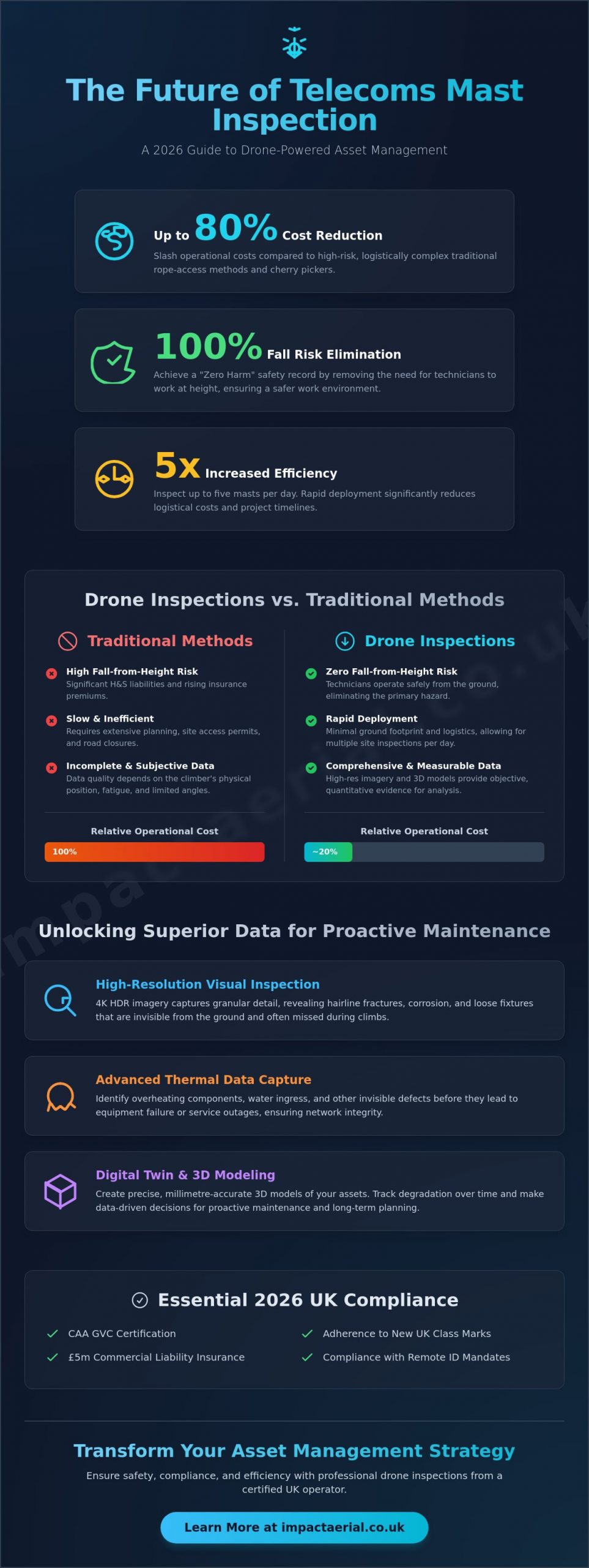
Drones vs. Traditional Methods: A Cost-Benefit Analysis
The commercial logic for adopting a drone inspection for telecoms masts is rooted in extreme efficiency gains. Traditional methods often require a team of two or more climbers and a full day to inspect a single structure. In contrast, a professional drone team can typically complete three to five mast inspections in a single day. This speed doesn’t come at the expense of detail; it actually enhances it. While a climber has a limited field of view and must focus on their own safety, a UAV provides 360-degree coverage of the asset. This perspective allows for a comprehensive assessment of every weld, bracket, and antenna from angles that are physically impossible to reach via a ladder or lift.
Safety remains the most significant driver for this technological shift. By deploying an unmanned system, you eliminate 100% of the fall-from-height risk for your inspection personnel. Keeping engineers on the ground reduces your health and safety liability and can lead to more favourable insurance terms over time. There’s also a clear environmental benefit to this approach. Drone operations require zero heavy machinery on-site, such as diesel-powered cherry pickers. This results in significantly reduced vehicle movements and a smaller carbon footprint for your maintenance cycles.
Reducing Operational Downtime
One of the most valuable aspects of modern aerial surveys is the ability to conduct “live site” inspections. Traditional climbing often necessitates planned outages to protect workers from RF radiation. Drones, however, can operate safely while the mast remains fully functional. This means you don’t have to sacrifice network uptime to perform structural checks. Real-time data streaming also allows remote engineers to view the high-resolution feed instantly. Decisions regarding repairs or hardware upgrades can be made on the spot, rather than waiting days for a climber to descend and file a manual report.
Long-term ROI and Predictive Maintenance
Shifting from reactive repairs to predictive maintenance is where the true return on investment lies. Early detection of minor issues like surface corrosion or loose cable ties can save millions in mast replacement costs over the asset’s lifecycle. Integrating this high-quality imagery into your existing Asset Management Software (AMS) creates a searchable, historical record of every mast in your fleet. For a broader look at how these processes work across different sectors, see our Drone Survey: The Complete Guide to Aerial Data Collection. By digitising your infrastructure, you move away from guesswork and toward a strategy based on verifiable, high-resolution evidence.
Safety, Compliance, and CAA Regulations in 2026
Compliance isn’t just a checkbox; it’s a fundamental risk management strategy. In 2026, the regulatory environment for a drone inspection for telecoms masts is more stringent than ever. Every commercial flight must align with the latest Civil Aviation Authority (CAA) standards to ensure public safety and asset protection. Operating near critical national infrastructure requires a level of oversight that goes far beyond basic flight skills. It demands a deep understanding of air law, technical limitations, and site-specific hazards.
Executing a drone inspection for telecoms masts in 2026 requires more than just technical skill; it demands total regulatory alignment. One of the most critical requirements for any telecoms project is a robust insurance policy. While standard commercial policies exist, the industry minimum for telecoms infrastructure is now £5m in commercial liability insurance. This level of coverage is necessary because masts are often located near public highways, residential areas, or high-value industrial sites. A professional operator provides more than just a drone; they provide a comprehensive Risk Assessment and Method Statement (RAMS) that outlines every safety protocol, from emergency landing zones to signal interference mitigation.
Professional pilots must also manage the technical challenge of RF interference. High-power antennas can disrupt standard GPS signals and control links. Our team uses shielded hardware and specific flight protocols to ensure the aircraft remains stable and responsive throughout the survey. This meticulousness is what separates a certified specialist from a generalist operator.
The Importance of GVC Certification
The CAA General Visual Line of Sight Certificate (GVC) is the mandatory qualification for pilots operating in the “Specific” category. This certification ensures that the pilot has undergone rigorous theoretical and practical testing. It covers everything from meteorology to complex navigation in congested areas. Hiring uncertified or “hobbyist” pilots creates an enormous legal and financial liability for telecoms firms. If an incident occurs, an uncertified operator’s insurance is often void, leaving the client exposed. To understand the full spectrum of legal requirements, read our UK Drone License: A Simple Guide to CAA Rules in 2026.
Risk Mitigation and Insurance
Meticulous pre-flight planning is the hallmark of a professional service. Every site survey begins with a detailed digital check of flight restrictions and local hazards. We also manage data privacy and GDPR compliance, which is a major concern when filming in urban environments. Our pilots use advanced software to identify potential interference zones before the drone ever leaves the ground. This proactive approach ensures hardware stability and data integrity. If you need a partner who prioritises compliance as much as quality, you can book a professional drone survey with our certified team today.
By adhering to these strict protocols, we ensure that every inspection is conducted with zero compromise on safety. This meticulousness allows us to operate in challenging urban environments where others cannot, providing the high-resolution data you need while maintaining a perfect safety record.
Impact Aerial: Professional Telecom Inspections Nationwide
Impact Aerial operates from a strategic base in Birmingham. This central location allows our team to serve the West Midlands and the entire UK with high-tier technical services. We recognize that a drone inspection for telecoms masts is a mission-critical task. It demands more than just basic flight skills. It requires a partner who understands the nuances of telecommunications infrastructure and the high stakes of network reliability. Our business is built on technical excellence. We utilize a commercial-grade DJI Enterprise fleet specifically equipped for precision work near high-interference towers.
We’ve established ourselves as a trusted specialist for the property, construction, and infrastructure sectors. Our approach is methodical and data-centric. We ensure that the information we provide is both accurate and legally compliant. By combining advanced hardware with meticulously trained pilots, we offer a level of reassurance that’s essential for large-scale asset management. We don’t just provide a service; we act as a technical consultant to help you improve your operational efficiency. Our team is proud of our professional affiliations and our commitment to industry standards.
Our Step-by-Step Inspection Process
The success of our surveys lies in a structured three-stage process. First, the Consultation phase ensures we understand your specific asset data requirements. We work with your engineers to identify critical components that need high-resolution documentation. Second, the Deployment phase involves our GVC-certified professional pilots arriving on-site for rapid data capture. They handle all logistical challenges, including site access and safety management. Finally, the Delivery phase sets us apart. We provide actionable insights through edited 4K video and high-resolution stills. This ensures the data is organized and ready for immediate engineering analysis.
Comprehensive Drone Solutions
Our expertise extends beyond structural checks to offer a complete suite of aerial services. We provide high-end aerial filming and photography for marketing materials. This helps you showcase your infrastructure projects to stakeholders with qualitative visual perspectives. For new builds, our construction site monitoring services allow for precise tracking of project milestones. We also offer virtual tour creation and drone commercial property surveys to support your broader portfolio management. We customize our reporting formats to fit your internal engineering workflows, which reduces the time your team spends on data entry.
Whether you’re managing a single rural site or a vast urban network, our team provides the reliability and precision you need. For a broader overview of how we support various industries, explore A Complete Guide to Professional Drone Services in the UK. We’re committed to delivering superior asset data while maintaining the highest standards of safety and compliance in the industry.
Elevate Your Asset Management Standards for 2026
The transition from manual tower climbing to data-centric aerial surveys is a strategic necessity for modern network providers. By adopting a professional drone inspection for telecoms masts, you replace high-risk logistics with high-resolution evidence. This ensures every weld and antenna is documented with millimetre precision. We’ve explored how 2026 CAA regulations and advanced thermal sensors have redefined what’s possible in structural health monitoring across the UK.
As you scale your 5G footprint or maintain legacy assets, the choice of partner is critical. Impact Aerial provides the technical expertise and regulatory reassurance needed to maintain a zero-incident safety record. Our team utilizes DJI Enterprise Commercial Hardware and carries £5m Commercial Liability Insurance. With our CAA GVC Certified Pilots, we’re ready to deliver actionable insights for your most complex sites. It’s time to move beyond reactive repairs and embrace a predictive maintenance strategy that protects your personnel and your bottom line.
Book a professional drone inspection for your telecoms assets with Impact Aerial today. Let’s work together to make your maintenance cycles faster, safer, and more cost-effective.
Frequently Asked Questions
Do I need to turn off the telecoms mast during a drone inspection?
No, you don’t need to power down the mast for a drone inspection. Unlike manual climbing where technicians must be protected from RF radiation, drones can operate safely while the equipment is active. This allows for continuous network uptime during the survey. It’s particularly useful for identifying thermal anomalies in active electronics that only appear when the system is under load, providing a more accurate health check.
Can drones fly near masts with high levels of RF interference?
Yes, professional drones can fly near high-interference towers. Commercial-grade DJI Enterprise models use advanced shielding and redundant GPS systems to maintain stability. Our pilots use specific flight protocols to mitigate signal disruption. This ensures the aircraft remains responsive even in dense electromagnetic environments. This capability is why a professional drone inspection for telecoms masts is superior to using consumer-level drones which often fail in these settings.
What is the maximum height a drone can reach for a mast survey?
Standard UK regulations limit drone flight to 120 metres (approximately 400 feet) above the ground. However, most cellular towers range from 50 to 200 feet, which falls well within the standard legal envelope. For taller structures, specific CAA authorization can be obtained. Our pilots manage all the necessary airspace notifications and permissions to ensure the survey remains fully compliant with current aviation law and safety requirements.
How long does a typical drone mast inspection take to complete?
A typical drone inspection for telecoms masts takes between 45 and 90 minutes on-site. This includes the initial safety briefing, pre-flight checks, and the actual data capture. The speed depends on the complexity of the hardware and the number of antennas. This rapid turnaround allows a single team to inspect multiple sites across a region in one day, significantly outperforming traditional rope-access methods.
What happens if the drone crashes into the infrastructure?
We prioritize prevention through meticulous risk assessments and hardware redundancies. Modern enterprise drones feature 360-degree obstacle avoidance sensors to prevent collisions. In the highly unlikely event of an incident, our £5m commercial liability insurance provides full coverage for any third-party property damage. Our pilots are trained in emergency procedures to ensure that the aircraft is safely recovered without compromising the integrity of your critical infrastructure or network.
Is a drone inspection for telecoms masts legal in urban areas?
Yes, it’s entirely legal to conduct drone inspections in urban environments provided the operator holds the correct certifications. Our pilots are CAA GVC certified, which allows us to operate in congested areas under specific safety protocols. We manage all the necessary Risk Assessments and Method Statements (RAMS) to ensure the flight is safe for the public and compliant with local council or highway regulations.
How much resolution can I expect from the inspection imagery?
You can expect high-resolution 4K HDR video and stills with at least 20 megapixels. This level of clarity allows engineers to zoom in on individual nuts, bolts, and cable ties with millimetre precision. Our equipment captures enough detail to identify hairline fractures or surface corrosion from a safe offset distance. This superior asset data is then delivered in a structured format ready for immediate technical review.
What certifications should I look for when hiring a drone pilot?
You should prioritize pilots with the CAA GVC (General Visual Line of Sight Certificate) for commercial operations in 2026. This ensures they’ve met the rigorous standards for air law and technical competency. Additionally, verify they hold at least £5m in commercial liability insurance. Look for providers listed on professional industry registers, as this indicates a commitment to the safety-conscious and meticulous approach required for high-value assets.
 2 Norton Drive, Wythall, Birmingham, B47 6HH Company registration number: 11138586. VAT Number: 366 9068 55


