
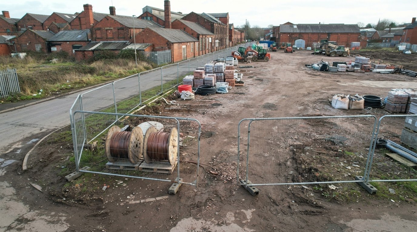
A security audit is only as useful as the evidence it produces. Drone data for a construction site security audit can provide aerial images and site models that document changing conditions, exposed areas and material movement. This helps teams review potential theft risks and keep a visual record of the site.
Fixed cameras and ground-level checks may leave some areas of a changing site harder to review. Aerial records provide a wider view to support security decisions, but they do not replace physical security measures or prove on their own that theft has occurred.
If you’re responsible for a construction site, you need evidence that supports decisions, not just impressive images. Drone surveys can contribute to risk reviews, incident response and maintenance planning. Their value depends on capturing useful, comparable data and relating it to site records. Construction site monitoring can help teams compare conditions over time and review visual evidence when an incident or maintenance concern needs attention.
Key Takeaways
- Learn how aerial records can help teams spot changes in equipment, materials and site access that merit closer attention.
- Understand how drone imagery can support an incident review by providing a visual record of site conditions.
- See how repeated surveys can inform maintenance planning and help track changing site conditions over time.
- Explore how survey timing can be shaped around site activity, emerging risks and the decisions the data needs to support.
Construction-site equipment and material theft
Construction theft can involve plant, tools, fuel, copper or materials stored before installation. A security review should account for items moving between delivery, storage and use, not just equipment left overnight. Drone imagery can record storage areas and access routes, helping teams identify changes between surveys. It may show, for example, an open section of perimeter or a stockpile that appears smaller than in an earlier record.
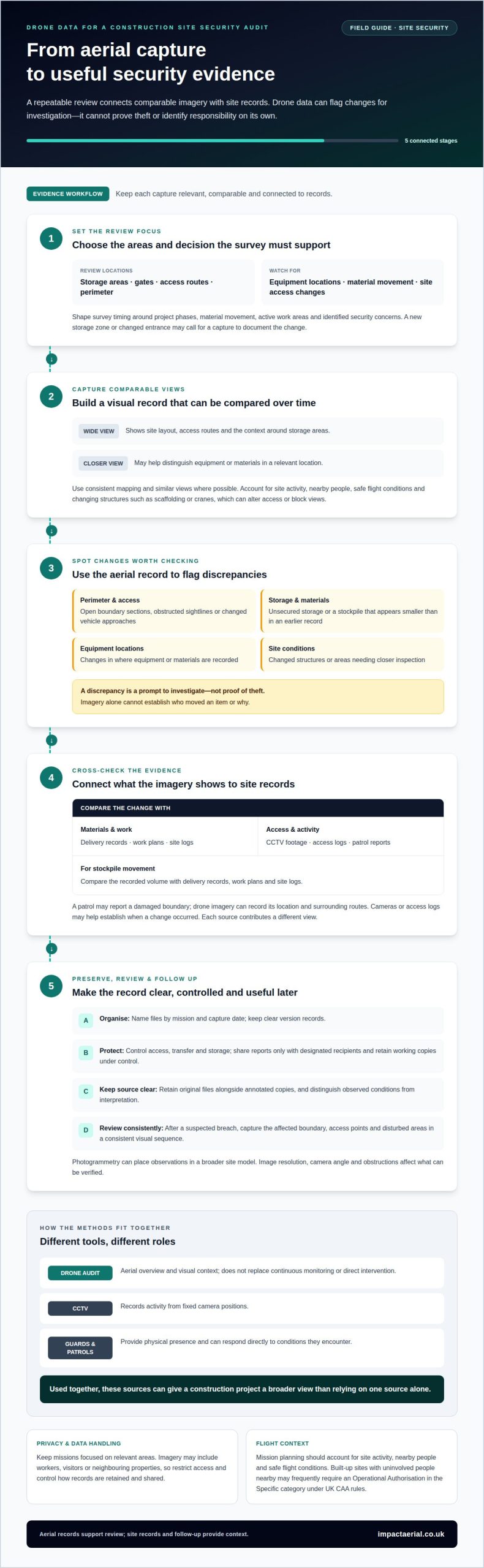
Repeated imagery is most useful when teams compare similar views. Clear images of storage zones, gates and temporary access roads can show how vehicles might approach or whether materials have moved. The level of detail matters: wider images show the site layout, while closer views may help distinguish equipment or materials. A drone record can flag a discrepancy for investigation, but it cannot establish who moved an item or prove theft.
Stockpile models can help track material movement during earthworks. If a recorded volume changes unexpectedly, teams can compare the model with delivery records, work plans and site logs. This makes drone data for a construction site security audit part of a wider evidence trail, rather than a standalone verdict. Thermal Image Surveys may serve a separate inspection purpose, but reviewing missing property still depends on visual records and site documentation.
Under UK CAA rules, a built-up construction site with uninvolved people nearby frequently requires an Operational Authorisation in the Specific category. The CAA renamed the A2 Certificate of Competency Near People (A2) from 1 January 2026; it is not a commercial licence.
Drone surveys should account for privacy and data protection when images include workers, visitors or neighbouring properties. Keep each mission focused on the relevant areas, restrict access to records and control how imagery is retained and shared.
Security risks visible from above include perimeter breaches, obstructed sightlines, unsecured storage areas and changes to equipment locations. The operator’s mission planning and training should account for site activity, nearby people and safe flight conditions. Scaffolding, cranes and temporary structures can also alter access or block views, so inspection records need to reflect the site as it changes.
Construction site security and incident response
Aerial monitoring adds a site-wide visual record that can help teams assess a security incident. Its value comes from comparing the imagery with site records and taking appropriate follow-up action.
Comparing Security Audit Methods
A drone security audit provides an aerial overview, while CCTV records activity from fixed camera positions. Guards and ground patrols, such as those deployed by Knight Owl Security Services, provide a physical presence and can respond directly to conditions they encounter. Each method has a different role, so using them together can give a construction project a broader view than relying on one source alone.
For example, a patrol may report a damaged boundary, after which drone imagery can record its location and surrounding access routes. Cameras or access logs may help establish when the change occurred. Aerial photographs show context, but do not replace continuous monitoring or direct intervention.
Secure Footage and Report Handling
Secure handling means controlling who can access footage, how it is transferred and how long working copies are retained. This matters because imagery may show workers, vehicles, neighbouring land or commercially sensitive construction activity.
A professional provider should organise files by mission and capture date, protect their transfer and storage, and share reports only with designated recipients. Reports should distinguish observed conditions from interpretation, with marked images identifying relevant locations. Clear file names and version records help teams find the right evidence during an incident review.
After a suspected breach, a provider can capture the affected boundary, access points and disturbed areas in a consistent visual sequence. The site team can compare these images with earlier records, delivery documentation and incident logs. Photogrammetry can place observations within a broader site model, but image resolution, camera angle and obstructions affect what can be verified.
Keep original files alongside annotated copies so reviewers can distinguish source imagery from report markings. Share only the material needed for the review and record who receives it. Aerial records can strengthen an incident timeline, but they do not identify a person or establish responsibility on their own.
For recurring site-wide records, construction site monitoring can provide a consistent aerial view to support security reviews and follow-up planning.
Construction-site security and maintenance
Drone surveys can support security reviews and maintenance throughout a construction project. Consistent aerial records help teams compare progress, site access and structural conditions as work changes.
Drone Survey Frequency
Survey frequency is the interval between captures of comparable site data. It matters because conditions on a changing construction site can make older images less useful for current decisions.
A survey schedule can reflect project phases, material movement, active work areas and identified security concerns. For example, a new storage zone or changed site entrance may call for a survey to document the change. Stable areas may need less frequent review than locations where access, equipment or structures change often.
Consistent mapping makes each capture easier to compare with earlier records. Visual models can show site progress, changes to storage layouts and areas needing closer inspection. Teams can then coordinate security reviews with maintenance planning instead of treating each survey as an isolated snapshot.
Planning and Conducting a Security Audit
A professional audit is a planned mission that captures agreed areas of a site for security and maintenance review. Careful planning matters because construction sites have changing access routes, structures and work zones.
First, establish the survey purpose with the site team, such as reviewing a boundary, checking a remote storage area or recording a structure’s condition. The site team provides relevant site information, access arrangements and priority areas. The provider can then plan a capture route and visual coverage suited to those needs.
During the survey, the operator records agreed areas and notes conditions that may affect the imagery, such as obstructions or changes to the layout. After capture, the provider reviews the imagery and can generate mapping or models for comparison with earlier records. This helps distinguish a new change from an existing feature, such as a relocated barrier or recently added structure.
The final report should identify observed conditions, relevant image locations and areas for follow-up. For example, a blocked access route can be recorded alongside the affected structure, giving maintenance or security teams useful context. Drone records support inspection and planning, while site personnel remain responsible for deciding and carrying out the appropriate response.
How often should drones survey a construction site for security?
No single survey interval suits every construction site. Set the schedule around security decisions, site activity and how quickly conditions change. A quiet storage area may need a different review pattern from an entrance used by deliveries and contractors. The aim is to capture useful comparisons, not simply collect images to a calendar.
Start with a baseline survey that records the site layout, access points and key storage areas. Repeat surveys when a meaningful change could affect security, such as a new entrance, relocated materials or a completed phase that opens previously restricted space. Repeating the same viewpoints makes changes easier to identify than comparing images taken from different positions.
Risk can also change during a project. If a boundary is altered or an incident is reported, a targeted survey can document the affected area and nearby access routes. It supports a review alongside site records, but does not replace immediate security measures or incident procedures. A subsequent scheduled survey can establish the updated baseline.
Align capture dates with project milestones and the site team’s review needs. For example, surveys can be planned around changes to storage arrangements, access routes or temporary structures. When work is stable, the team may prioritise key milestones; when conditions change rapidly, more frequent review can provide timely comparisons. Weather, access and safe flight planning also affect when a mission can proceed.
Agree on each survey’s purpose before setting its timing. A record intended to track a boundary needs repeatable views of that boundary; a review of material movement needs images showing the relevant storage areas. Tying each capture to a clear decision helps avoid collecting imagery that adds little value.
To plan a survey schedule around your site’s security needs, discuss construction site monitoring.
Impact Aerial: Drone Commercial Property Surveys
Impact Aerial provides Drone Commercial Property Surveys and Construction Site Monitoring for teams that need clear aerial records to support site reviews. These services can document changing conditions, monitor progress and give security teams visual context for maintenance or incident follow-up.
For a construction project, the survey can be planned around priority areas such as boundaries, access routes and material storage. Impact Aerial operates with CAA GVC certified pilots and commercial-grade professional drones equipped with 4K HDR cameras, supporting detailed aerial capture. The required survey approach depends on the site layout and the information the team needs to review.
If you’re planning a construction site survey or monitoring programme, contact Impact Aerial to discuss the project.
Turn site observations into a clear next step
Decide what your team needs the next aerial record to help assess. A defined purpose, such as reviewing changing access or documenting a property condition, gives the survey a practical role in site planning. Drone data for a construction site security audit is most useful when the imagery supports a decision, identifies the responsible team and informs appropriate follow-up.
Impact Aerial also provides Aerial Filming and Photography, PV Solar Farm Thermal Surveys and Drone Commercial Property Surveys. These services address different aerial data needs in commercial settings, with the project’s purpose guiding the brief.
If you’re considering a survey for your site, contact Impact Aerial to discuss your site. A clear conversation about the area and information you need can help shape a focused next step for your project.
Frequently Asked Questions
How can drone data be used to audit construction site security?
Drone data can help teams assess whether site controls are working as intended. An aerial view, for example, may show whether a delivery route passes close to restricted storage or whether temporary works have changed visibility around an access point. Linking these observations to the site security plan helps teams prioritise a practical review instead of treating imagery as proof of an incident.
What drone imagery and data should a construction site security audit collect?
Capture imagery that shows the overall site layout as well as clear views of the areas under review. A report can identify image locations, capture dates, notable obstructions and the distinction between direct observations and interpretation. If a temporary structure blocks part of a boundary view, recording that limitation helps reviewers understand the evidence. Keep the information relevant to the audit’s purpose.
What drone survey providers serve construction sites in the UK?
Impact Aerial provides Construction Site Monitoring and Drone Commercial Property Surveys across the UK. Construction teams can use these services to obtain aerial records for site reviews or to document commercial property conditions. A brief that identifies areas of interest, intended use of the imagery and site access arrangements helps define a focused survey scope.
What UK privacy and data protection rules apply to drone surveillance on construction sites?
Drone surveillance should account for privacy and data protection when imagery includes workers, visitors or neighbouring properties. Keep missions focused on security areas, restrict access to relevant records, and control how imagery is retained and shared.
 2 Norton Drive, Wythall, Birmingham, B47 6HH Company registration number: 11138586. VAT Number: 366 9068 55


