
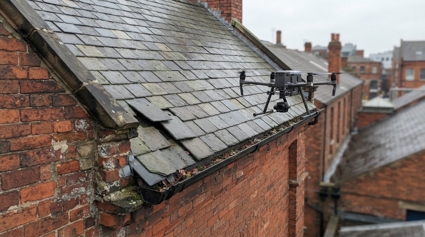
A roof doesn’t always need to be walked on to be inspected. A roof survey documents visible condition, identifies signs of damage and helps determine whether further investigation is needed. For hard-to-reach roofs, inaccessible roof inspection solutions can make an assessment possible without placing an inspector on the roof. A visual survey can also record gutters and potential leak areas, although it can’t establish every hidden cause of water ingress.
It’s understandable to want clear answers without risking roof damage or putting people in an unsafe position. This article explains how visual roof surveys, gutter inspections and leak investigations can help assess difficult-to-access areas, what each method can reveal and where its limits lie. It also covers how the building, roof design and inspection objective shape the approach, and when aerial imagery can provide useful evidence for a property survey.
Key Takeaways
- Match the inspection method to the roof’s access, layout and the evidence needed to investigate a leak.
- Use visual roof and gutter checks to identify visible concerns while recognising when they can’t reveal hidden causes.
- Reduce avoidable roof damage and inspector exposure by considering access risks before anyone approaches the roof surface.
- Understand how UK drone rules and professional flight planning shape aerial inspections of commercial properties.
Roof surveys, gutter inspections and leak investigations
A roof survey records visible condition and helps target maintenance or further investigation. Commercial flat roofs should be inspected annually, while insurers may ask homeowners to arrange pitched-roof inspections. Inaccessible roof inspection solutions can gather useful visual evidence where direct access is difficult.
Survey Purposes and Benefits
A survey can document damaged coverings, blocked gutters, displaced materials and visible drainage issues. For example, images of a cracked roof covering near a damp ceiling can help focus a leak investigation. The report provides a record for maintenance planning or a property transaction. During conveyancing, a visual survey gives buyers information about visible condition, but doesn’t establish every concealed defect.
Survey Costs and Remedial Support
Survey costs depend on the project scope, roof complexity, access method and level of reporting. A visual review differs from work requiring multiple viewpoints, thermal imagery or measured roof data. A report can prioritise visible defects and help property managers plan remedial work. A survey is an assessment, not a repair: its findings help determine what needs attention and where closer inspection may be useful.
Drone and Thermographic Survey Options
A drone can photograph roof slopes, edges, rooflights and gutters from multiple angles without an inspector walking on the surface. Thermographic imagery records temperature patterns that may help identify areas for further investigation, but it doesn’t prove the cause of a leak. For solar installations, PV Solar Farm Thermal Surveys capture thermal patterns across panels. Choose a method according to the evidence the project needs.
Remote Inspection Arrangements and Drone Rules
To arrange a remote survey, provide the property location, roof type and concern, such as water ingress near a chimney. The operator plans the method, assesses site constraints, carries out flight-risk planning and captures imagery for a report. When choosing a UK provider, look for relevant CAA credentials, roof-survey experience and clear reporting. Drone-based inaccessible roof inspection solutions also require attention to permissions and the management of any drone exclusion zones.
Property damage and inspector safety
Walking on a roof can damage coverings or expose an inspector to an unsafe surface. A roof should only be walked on if it’s designed to support a person’s weight. Visual checks from the ground or aerial imagery can help assess slates, flashings and roof edges before anyone considers closer access. For a commercial building, recording the location of visible damage also helps distinguish urgent concerns from routine roofing maintenance.
After a storm, photographs can document displaced tiles, lifted flashing, damaged gutters or debris before repairs are planned. A remote survey can help identify affected areas and provide a visual record for property managers and repair teams. It doesn’t carry out emergency repairs or confirm hidden structural damage. If water is entering the building, images can help show where staining appears inside and where an exterior inspection should focus.
Chimneys need careful visual assessment because damage may involve the stack, mortar joints, flashing or chimney pot. A drone view can show whether a cap appears displaced or the chimney top has visible deterioration. That evidence can guide decisions about closer inspection and suitable repairs. A cap isn’t the solution to every leak: the report should distinguish visible defects from suspected causes that need further investigation.
Access points also need to be assessed before entry. If an inspector opens a roof-void manhole, they should check the surrounding area for damage and confirm it can support their weight. A weak ceiling edge or damaged access panel changes the safe approach. Remote imagery can reduce unnecessary contact with the roof, while a clear record helps plan follow-up work without assuming the roof can safely carry a person.
For buildings where roof access creates avoidable risk, drone commercial property surveys can provide exterior imagery to support inspection planning. The images help assess visible damage; repairs still require a separate, appropriate work plan.

Professional visual roof inspections
A professional visual inspection turns roof imagery into a structured record of visible condition. The survey can map roof slopes, ridges, valleys, chimney junctions, rooflights and drainage details, then label concerns by location. For example, a report can distinguish a displaced ridge tile from staining beside a rooflight. Inaccessible roof inspection solutions provide useful evidence, but photographs alone don’t establish hidden structural condition or prove the cause of water ingress.
Where a drone cannot safely or practically capture a useful angle, tripod-based scanning offers another method. A high tripod can scan from outside or through skylights without anyone walking on the roof. Terrestrial laser scanning requires positions around the building, as each captures different surfaces. Where access and roof complexity allow, a horizontal tripod can place a scanner outside, including at a window. The survey plan should account for chimneys and other sightline obstructions.
Photogrammetry creates three-dimensional roof geometry from multiple photographs while retaining detailed RGB colour information. This can help assess a complex roof installation and relate visible defects to nearby features. Processing the images takes time and computing resources. A UAV-mounted mobile laser scanner can capture three-dimensional information faster, but its point cloud is less accurate than photogrammetric surveying and provides less detailed RGB inspection.
Choosing between inaccessible roof inspection solutions depends on the required output. A visual condition record may suit maintenance planning, while measured geometry can support design or installation work. Digital roof measurement is faster and less error-prone than conventional manual measurement. The final report should identify the method used, imagery or scan data captured, visible areas and any limitations affecting interpretation. A survey can record a cracked chimney joint or displaced flashing, but cannot confirm concealed structural damage without further investigation. Clear labels help building owners and follow-on professionals use each observation.
What UK regulations apply to drone roof inspections and commercial drone operators?
In the UK, the Civil Aviation Authority (CAA) provides the framework for drone operations. A roof survey flight plan needs to account for the aircraft, location and task. Pilot credentials are one part of professional practice, alongside site-specific planning. Impact Aerial’s pilots are CAA-GVC Certified, and the company holds full UK CAA Operational Authorisation. Each property still requires its own operational assessment.
Before flight, the operator identifies the permissions required for the proposed operation and assesses site risks. A city-centre roof may have different constraints from an isolated industrial building. Nearby people, access points, surrounding structures and the intended flight path can all affect how imagery is captured. If an exclusion zone is needed, it should be managed as part of the planned operation, not improvised during the survey.
Commercial operators also need to consider whether the planned flight can gather the required evidence safely. A close view of a chimney, rooflight or parapet may call for a different camera position from a broad roof overview. Weather, visibility and obstacles can influence the practical method. The operator’s assessment should define the inspection area, planned viewpoints and conditions that would require the flight to change or stop.
For property owners, useful evidence of a professional process includes the pilot’s relevant credentials, a documented risk assessment and a clear explanation of the planned survey. The final imagery or report should identify what was observed and which areas couldn’t be assessed from the available views. This makes the results more useful for maintenance decisions without presenting a visual survey as a structural assessment.
For commercial buildings that need documented aerial imagery, arrange a drone commercial property survey with a defined inspection area and reporting purpose.
Impact Aerial
Impact Aerial helps property teams gather aerial imagery when roof access is difficult or could create avoidable risk. Its Drone Commercial Property Surveys can document visible roof areas, elevations and access constraints, giving building managers clearer visual information for inspection planning. The imagery supports assessment of visible condition, but doesn’t replace a specialist diagnosis or carry out repairs.
For a property project, define the areas of concern and the information needed, such as imagery of roof edges, drainage features or a chimney. This helps shape a focused survey and useful output. Contact Impact Aerial to discuss your roof inspection requirements.
Plan the next step for your roof
The most useful next step is to define what decision the inspection needs to support. A maintenance plan, a leak investigation and a property record may each call for different imagery and levels of detail. Clear objectives shape inaccessible roof inspection solutions around the building, access constraints and evidence required, rather than collecting images without a defined purpose.
Impact Aerial’s work includes Aerial Filming and Photography, PV Solar Farm Thermal Surveys and Drone Commercial Property Surveys. These services support projects that need aerial visual information, from commercial property assessments to thermal surveys of solar farms. A useful brief identifies the property, areas of concern and intended use of the survey output.
Share those details to discuss a practical approach for your building. Contact Impact Aerial about your roof inspection and take the next step with a clear project scope.
Frequently Asked Questions
What is the purpose of roof survey?
A roof survey provides evidence about visible condition so owners can plan maintenance, investigate concerns or make informed property decisions. For example, a survey may help distinguish a localised issue near a rooflight from wider deterioration across a roof slope. Its value depends on matching the inspection scope and report detail to the decision at hand, rather than treating every survey as a full structural assessment.
What surveying methods can identify hidden moisture or leaks?
Thermographic imagery can reveal temperature patterns that may point to areas needing closer moisture investigation, but it doesn’t prove a leak exists or identify its source on its own. A follow-up assessment can compare the flagged area with internal signs, such as staining below a roof junction. The appropriate method depends on the roof construction, suspected entry point and whether access is available from inside.
What methods are used to inspect inaccessible roofs in the UK?
Methods include drone imagery, tripod-mounted laser scanning, photogrammetry and access equipment such as scaffolding, mobile elevating work platforms or rope access. The choice depends on the building layout and the evidence needed. A complex roof with hidden surfaces may need several viewpoints or a combination of methods. For example, a chimney behind a parapet could require a different camera angle from an open roof slope.
How do drone roof inspections compare with scaffolding, cherry pickers and rope access?
A drone can capture exterior views without placing an inspector on the roof, making it useful for documenting broad areas or difficult elevations. Scaffolding, cherry pickers and rope access can bring people closer for hands-on examination or repairs, but each requires suitable access and site planning. For structures requiring physical examination, specialists such as Dangle® provide professional rope access and height safety expertise. Drone imagery cannot test materials, clear gutters or complete repairs, so it can inform physical work but not replace it.
How much does a drone roof inspection cost in the UK?
There isn’t one fixed UK price for every drone roof inspection. The fee depends on the property, survey scope, access constraints and reporting requirements. Impact Aerial offers a free, no-obligation quote on request, based on the project details. A useful quote should clarify the inspection area and expected deliverables, so you can assess whether the proposed survey suits your purpose.
What factors determine the cost of inspecting a hard-to-access roof?
Cost depends on the roof’s size and complexity, the number of areas needing coverage, site constraints and reporting requirements. A survey focused on one roof section differs from one documenting multiple elevations, rooflights and plant areas. Intended use also matters: maintenance records may need different outputs from a measured survey. A clear scope helps ensure the quote reflects the project.
 2 Norton Drive, Wythall, Birmingham, B47 6HH Company registration number: 11138586. VAT Number: 366 9068 55


