
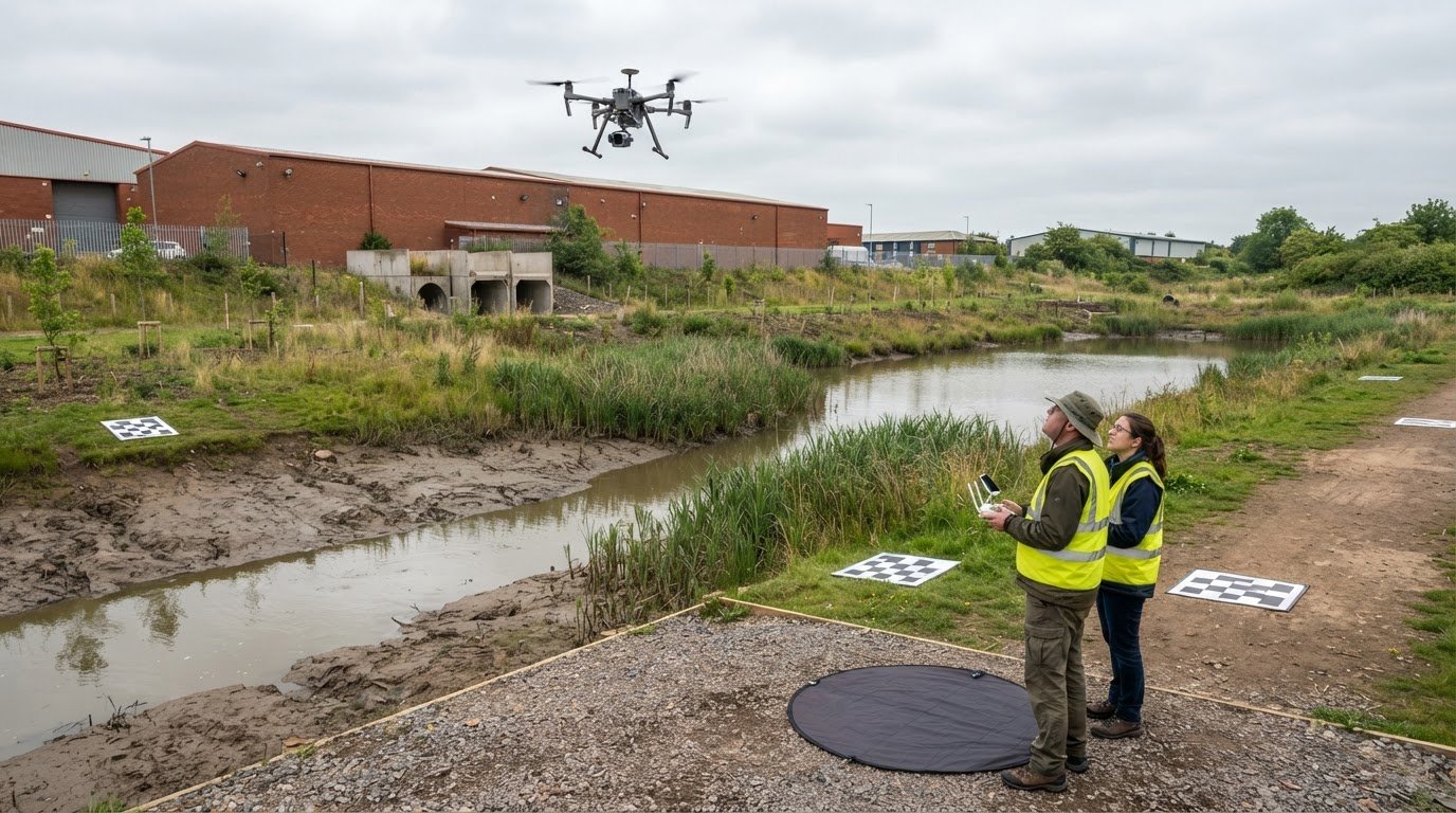
Environmental drone reporting is only as useful as the evidence it produces. Drone data for environmental compliance reporting can include aerial imagery, mapped outputs and sensor readings to document site conditions and changes over time. The right method depends on what needs monitoring, from terrain and vegetation to air quality.
That evidence can support a clearer reporting workflow, but the flight is only one part of the process. Permissions, operational planning and suitable insurance also matter, particularly when a site or flight plan presents additional risks.
This guide explains how drones collect environmental data, how GIS can help turn survey outputs into reporting evidence, and what to consider about permissions and insurance in the UK. It also covers how different sensors are used, why consistent data collection matters, and how aerial surveys can support environmental monitoring without overstating what the results show.
Key Takeaways
- Choose drone surveys when aerial coverage and repeatable imagery can help document site changes; consider how the method complements ground-based monitoring.
- Match sensors to the environmental question, since imagery, thermal data and air-quality measurements provide different kinds of evidence.
- Use GIS to organise survey outputs, compare conditions over time and make findings easier to interpret in environmental reports.
- Plan for permissions, insurance and consistent data handling alongside the flight, and consider commercial property surveys when aerial site information is needed.
How Do Drones Monitor the Environment?
Drones collect aerial imagery and sensor data to map site conditions, track changes and support environmental monitoring. Their value depends on matching the survey method to the question and producing records that can be compared and reviewed.
Drone Surveys Compared With Traditional Methods
Drone surveys collect aerial data across sites that may be difficult to cover consistently on foot. Photogrammetry and LiDAR produce terrain and vegetation models, while repeat imagery can reveal changes across a site. A single flight can cover hundreds of hectares, depending on altitude and sensor type.
Compared with some crewed aircraft surveys, drones can perform certain tasks without using a crewed aircraft. Battery-powered drones produce no direct emissions while in flight. They do not replace ground observations in every situation, but can add a broad visual record. Multispectral surveys can also help assess vegetation condition using indices such as NDVI and NDRE.
GIS-Ready Maps and Survey Exports
Survey processing can produce a georeferenced orthomosaic, a single measurable map assembled from aerial images, alongside terrain models and elevation profiles. Digital terrain models represent the ground; digital surface models capture visible features above it. Contour lines can be prepared at intervals suited to the project.
GIS-ready outputs make it easier to overlay survey evidence with other mapped information. Orthomosaics may be delivered as GeoTIFF files, while survey exports can include LAS/LAZ, DXF and SHP formats. These files help environmental teams inspect mapped conditions, identify areas of interest and document findings within familiar spatial workflows.
Repeat Surveys and Time-Series Data
Repeat surveys create a time-series dataset by documenting the same area on a recurring schedule, such as weekly or monthly. Comparing mapped outputs can show where vegetation, terrain or site conditions have changed, helping teams distinguish a developing pattern from a single observation.
Consistency matters. Keep flight altitude, image overlap, speed, camera angle, ground sampling distance, time of day and season as consistent as possible. Seasonal differences in vegetation can affect comparisons, so record when each survey took place to help explain what the imagery shows.
Survey Accuracy and Data Defensibility
Defensible survey data depends on traceable collection and processing, not imagery alone. Record flight conditions and metadata, verify planned coverage, and document unusual observations. These records help analysts understand how each dataset was collected and identify gaps before using it to support reporting.
Consistent capture settings strengthen comparisons, while GIS-ready maps connect observations to specific locations. Keep original files and processed exports together, with clear dates and labels. This creates a reviewable record of survey coverage and supports careful interpretation, without treating an aerial image as proof of a cause.
Drone sensors and environmental data collection
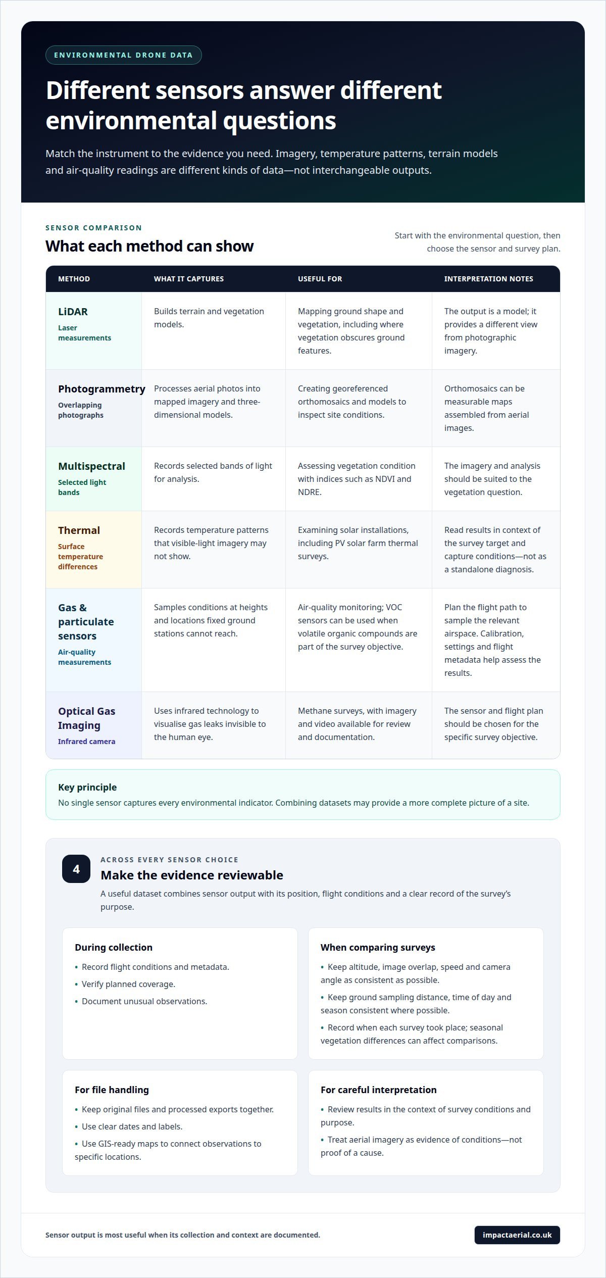
A sensor determines what an aerial mission can capture, so selection starts with the environmental question. Mapping terrain, assessing vegetation and detecting a possible gas release require different instruments. A useful dataset combines sensor output with its position, flight conditions and a clear record of the survey’s purpose.
LiDAR uses laser measurements to build terrain and vegetation models, including in areas where vegetation obscures ground features. Photogrammetry processes overlapping photographs into mapped imagery and three-dimensional models. Multispectral sensors record selected light bands; analysts can use indices such as NDVI and NDRE to assess vegetation condition. These outputs support different forms of analysis and should not be treated as interchangeable.
Thermal sensors record differences in surface temperature, which can help identify patterns that ordinary visible-light imagery may not show. For example, PV solar farm thermal surveys use thermal imagery to examine solar installations. The interpretation depends on the survey target and conditions during capture, so thermal results should be read in context rather than treated as a standalone diagnosis.
For air-quality work, drone-mounted gas and particulate sensors can sample conditions at heights and locations that fixed ground stations cannot reach. Methane surveys may use Optical Gas Imaging cameras, which use infrared technology to visualise gas leaks invisible to the human eye. The resulting imagery and video can be reviewed and documented. VOC sensors are used when monitoring volatile organic compounds is part of the survey objective.
Sensor choice affects the mission plan and the evidence produced. A gas instrument needs a flight path that samples the relevant airspace; a vegetation survey needs imagery suited to its analysis. Calibration, sensor settings and recorded flight metadata help analysts judge whether results are accurate enough for their intended use. No single sensor captures every environmental indicator, so combining datasets may provide a more complete picture of a site.
GIS integration and environmental reporting workflows
GIS gives environmental teams a spatial framework for interpreting drone outputs alongside site information. Organising project data by purpose makes maps easier to read and the reporting workflow easier to follow.
Collecting Drone Data
In a GIS workflow, collection planning also determines how the resulting information will fit the project’s spatial structure. Teams can define map boundaries and monitoring zones that align with existing site plans, so each output can be interpreted in the right area.
For example, a site may be divided into habitat areas, drainage corridors and operational zones. Assigning outputs to these mapped areas helps analysts compare relevant features without treating the whole site as uniform. This organisation gives later reporting clearer spatial context.
Processing and Validating Drone Data
GIS processing can organise outputs into separate layers, such as orthomosaics, terrain models and interpreted observations. Layer names and attributes should describe their purpose, date and relevant measurement, helping analysts distinguish source imagery from derived findings.
Spatial alignment is also important. If a drone layer does not line up with the site boundary or another reference layer, apparent changes may reflect a mapping mismatch rather than an environmental change. Reviewing layer alignment supports sound interpretation before findings are presented.
Reporting Drone Data Through GIS
GIS can make drone data for environmental compliance reporting more useful by connecting mapped observations with relevant site zones and report topics. Readers can move from a summary finding to its location on a map, then examine the associated layer.
For clarity, reports can use a consistent legend, labelled boundaries and concise notes explaining each layer. Separate layers for observed features and interpreted areas, for instance, help readers distinguish direct visual evidence from analysis. This structure makes complex spatial information easier to understand.
Regulatory Acceptance and GIS Integration
GIS organises and presents evidence, but does not automatically establish that the evidence is suitable. The reporting requirement determines which outputs and measurements are relevant and how they should be explained to a reviewer.
Drone data for environmental compliance reporting should make clear how each mapped result relates to the report’s monitoring objective. GIS can support this through organised layers and readable map extracts. Sensitive-species locations and confidential datasets also need appropriate access controls and secure storage.
What are the steps for collecting, processing, validating, and reporting drone data?
A reliable environmental survey follows a documented workflow from mission planning to final report. Clear responsibilities, collection procedures and quality controls help keep each dataset traceable and suitable for its intended analysis.
- Define the survey. Set the monitoring objective, site boundary, sensor requirements and planned coverage. Assign pilot and analyst responsibilities, then record the flight and data-collection procedures. For a vegetation assessment, specify the area and imagery needed before the mission begins.
- Prepare and collect. Set sensor calibration requirements and confirm the planned coverage. During the flight, record conditions and metadata, such as the sensor settings and collection context. Document unusual observations so analysts can distinguish a notable feature from a routine part of the site.
- Process the files. Organise captured data and create the required survey outputs, such as mapped imagery or terrain models. Keep source files associated with processed results. That link lets an analyst trace a mapped observation back to the data used to produce it.
- Validate coverage and quality. Review the outputs against the planned area and quality-control standards. Look for missing coverage, incomplete files or processing issues before the data informs a report. Back up files before leaving the site, and note any observations that need further analysis.
- Report and retain. Present findings with their location, survey context and supporting outputs. Separate visible observations from interpretation, and explain how the data relates to the monitoring objective. Store records securely, control access to confidential datasets and follow applicable agency or landowner data-sharing requirements.
This sequence makes collection and analysis easier to review later. For an environmental project involving aerial site information, discuss a drone survey as a potential part of the evidence-gathering workflow.
Impact Aerial: Drone Commercial Property Surveys
Impact Aerial provides Drone Commercial Property Surveys for businesses that need aerial information about a site or building. This service can help document visible conditions when a property survey is appropriate, rather than when a project requires specialist environmental sensor measurements.
For other visual requirements, Impact Aerial also provides Aerial Filming and Photography, PV Solar Farm Thermal Surveys, and Construction Site Monitoring.
Contact Impact Aerial to discuss a Drone Commercial Property Survey for your site.
Make the next survey fit the decision
Before planning a survey, define the decision the evidence needs to support. Identify the site, the environmental question and how the resulting data will be used. This gives the flight and reporting workflow a clear purpose and helps determine whether aerial imagery or specialist thermal capture is the better fit. Effective drone data for environmental compliance reporting starts with this practical alignment.
Impact Aerial’s Aerial Filming and Photography, PV Solar Farm Thermal Surveys and Drone Commercial Property Surveys address different visual requirements. Matching the service to the site and intended output keeps the project focused on useful evidence, rather than collecting data without a clear reporting need.
Contact Impact Aerial to discuss your project and the information you need to capture. A well-defined objective is a strong starting point for a clear, useful survey.
Frequently Asked Questions
What drone data can be used for environmental compliance reporting?
Useful data depends on the condition being documented and the evidence the report needs. A site inspection might use georeferenced photographs to record a drainage feature, visible ground disturbance or a change near a boundary. Vegetation indices, thermal imagery and gas readings provide different measurements, so reports should identify what each dataset represents and avoid treating visual evidence as a direct chemical measurement.
Which UK environmental regulations require or accept drone survey data?
There is no universal acceptance rule for every UK environmental report. Whether drone evidence meets a requirement depends on the relevant permit, consent or monitoring plan, including any specified sampling method. A mapped image may document a visible site condition, but should not be presented as a substitute for required laboratory sampling or other prescribed measurements unless the relevant requirement allows it.
What standards and accuracy requirements apply to drone data used in compliance reports?
Accuracy requirements depend on the report’s purpose and the measurement being made; a habitat overview and a boundary measurement don’t have identical needs. State the sensor, capture method, processing approach and known limitations so reviewers can assess the evidence. According to ASTM International, ASTM D8559-24 is a standard for portable and fixed-point ambient air quality sensors, not a universal accuracy standard for drone surveys.
How can drone surveys monitor emissions, water quality, habitats, waste sites, and land pollution?
Drones can map visible site features and collect sensor readings when the equipment suits the target. Optical Gas Imaging can record infrared imagery of visible gas-release patterns for analysis. For water, habitat, waste or land-pollution work, aerial mapping can identify locations or visible changes for follow-up. Imagery alone does not establish water chemistry or prove contamination; those conclusions require suitable measurements and interpretation.
What permissions and rules apply to commercial environmental drone flights in the UK?
Requirements depend on the planned operation, location and risks. Flights beyond visual line of sight, over sensitive sites or across industrial facilities often need specific permissions, such as an Operational Authorisation supported by a SORA assessment. Operators should consider applicable aviation rules and insurance alongside land access, site restrictions and protection of sensitive environmental data.
How do drone surveys compare with satellite imagery and traditional environmental monitoring?
Drones provide targeted aerial capture that can be planned around a particular site or feature. Satellite imagery can support wider-area observation, while ground monitoring can collect direct measurements at selected locations. Drones can add close visual context between these methods, such as mapping a defined section of a habitat or waste site. The suitable approach depends on coverage, measurement needs and how often observations are required.
 2 Norton Drive, Wythall, Birmingham, B47 6HH Company registration number: 11138586. VAT Number: 366 9068 55


