

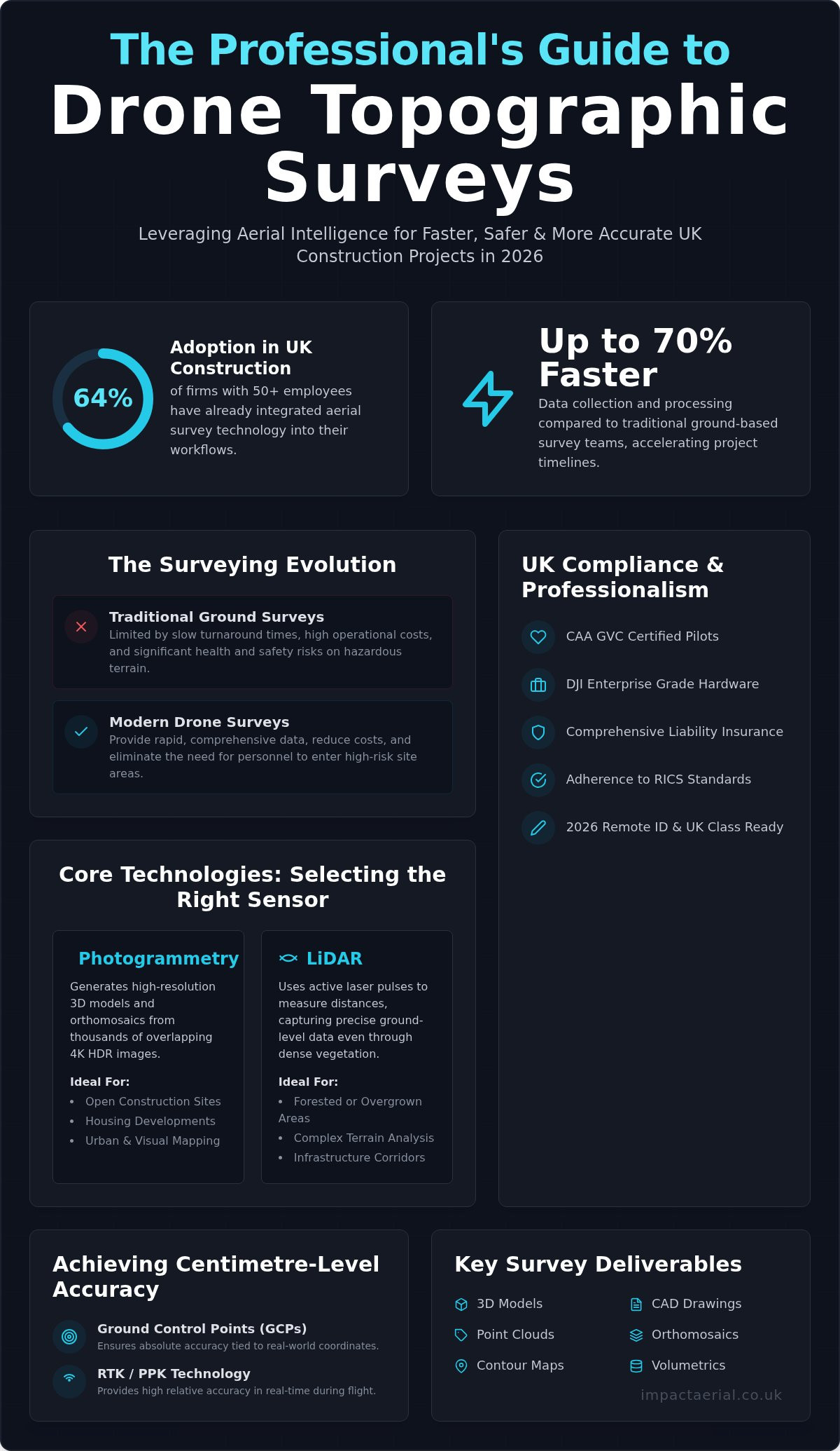
Did you know that 64% of UK construction firms with 50 or more employees have already integrated aerial technology into their site surveying workflows? It’s a clear signal that the industry is moving away from the limitations of traditional methods. You’ve likely experienced the common frustrations of ground-based surveying: the slow turnaround times, the high costs, and the genuine safety risks involved in sending personnel onto hazardous or uneven terrain. Relying on inconsistent data from uncertified operators can jeopardize your entire project timeline and budget.
This professional guide explores how a precision drone topographic survey UK provides a faster, safer, and more accurate data solution for your 2026 property and construction projects. We’ll show you how to leverage CAA GVC certified expertise and DJI Enterprise hardware to produce high-resolution 3D models and CAD drawings that meet strict RICS standards. From navigating the 2026 CAA registration thresholds to choosing between photogrammetry and LiDAR, you’ll learn how to secure reliable site intelligence while maintaining full regulatory compliance and operational safety.
Key Takeaways
- Learn the technical distinctions between photogrammetry for high-resolution 3D models and LiDAR for capturing ground-level data through dense vegetation.
- Discover how to achieve centimetre-level relative and absolute accuracy for your site data using Ground Control Points and RTK technology.
- Understand the essential regulatory requirements for a drone topographic survey UK, including the necessity of CAA GVC certified pilots and comprehensive liability insurance.
- Identify why choosing a technical consultant with DJI Enterprise hardware provides superior data quality and safety compared to standard commercial drone operators.
Understanding Drone Topographic Surveys in the UK Construction Sector
A professional drone topographic survey UK is no longer a luxury reserved for high-budget infrastructure projects; it’s a foundational requirement for modern site management. At its core, drone topography involves the systematic capture of georeferenced data points to create a precise digital twin of a landscape. Unlike standard aerial photography, these surveys utilize high-precision sensors to record X, Y, and Z coordinates, allowing for the creation of detailed 3D models and contour maps. This technical approach ensures that every change in elevation and every physical feature is documented with centimetre-level accuracy.
The UK construction industry is currently undergoing a rapid digital transformation, with 64% of firms employing 50 or more people now utilizing drones for site surveys. This shift is largely driven by the principles of Digital Value Engineering (DVE). By integrating aerial data into the early stages of design and planning, project managers can identify potential site constraints before they become costly errors. The efficiency gains are undeniable. Professional aerial methods allow for data collection that is up to 70% faster than traditional ground-based teams. Furthermore, it eliminates the need for surveyors to navigate hazardous terrain or active plant machinery, which significantly reduces the overall health and safety risk profile of a project.
The Evolution of Land Surveying
Land surveying has evolved significantly from the era of total stations and manual GPS rovers. While traditional tools remain essential for specific setting-out tasks, they are often too slow for large-scale site characterisation. Modern aerial survey techniques provide a much denser data set in a fraction of the time. By 2026, the professional landscape has been further refined by the introduction of the UK class marking system (UK0 to UK6) and mandatory Remote ID. These regulatory updates ensure that only compliant, high-spec hardware is used on commercial sites. These advancements mean that the precision of a drone-led survey now consistently meets the RICS global professional standards for measured surveys of land and buildings.
Commercial Applications Across the UK
The versatility of drone mapping makes it applicable across various sectors in the UK. For housing developments, these surveys are vital for land adoption, drainage planning, and ensuring compliance with local planning authorities. In the realm of infrastructure, drones provide essential highways mapping without the need for expensive and disruptive road closures. The quarrying and mining industries also rely heavily on this technology for volumetric analysis. Drones can calculate the exact volume of stockpiles or excavations with high precision, providing data that would be dangerous and time-consuming to gather through manual methods. Whether it’s a small development in the West Midlands or a nationwide infrastructure project, the data remains consistent, reliable, and compliant.
The Technical Edge: LiDAR vs. Photogrammetry for Terrain Mapping
The efficiency of a drone topographic survey UK depends heavily on selecting the correct sensor for your site’s specific environmental conditions. While both photogrammetry and LiDAR generate high-density point clouds, they operate on different principles. Photogrammetry relies on overlapping 4K HDR imagery to triangulate 3D coordinates. LiDAR, conversely, uses active laser pulses to measure distances. Professional operators must evaluate site terrain, vegetation density, and required deliverables before deployment. Adhering to the UK Drone and Model Aircraft Code ensures these technical operations remain safe and compliant within British airspace.
When to Choose Aerial Photogrammetry
Photogrammetry is the industry standard for open construction sites, housing developments, and urban mapping projects where visual clarity is as important as spatial data. By using DJI Enterprise hardware capable of 4K HDR capture, we can produce detailed orthomosaics and textured 3D models. This method is highly cost-effective for sites with clear lines of sight to the ground. It provides a rich visual record that aids in stakeholder communication and site monitoring. If your project requires high-resolution visual documentation alongside centimetre-accurate mapping, photogrammetry is often the optimal choice.
The Power of Aerial LiDAR
Aerial LiDAR (Light Detection and Ranging) is the superior choice for complex environments such as dense woodland or overgrown brownfield sites. Unlike cameras, LiDAR sensors emit laser pulses that can slip through gaps in foliage, reaching the earth’s surface beneath. In the context of UK forestry or overgrown brownfield sites, LiDAR provides the necessary penetration to achieve sub-50mm vertical accuracy by filtering out surface clutter to find the true ground level. This capability allows for the generation of precise Digital Elevation Models (DEM) even in areas where the ground is completely obscured from view.
Processing LiDAR data is typically faster than photogrammetry because the sensor directly records 3D coordinates rather than requiring the intensive image-matching calculations associated with photogrammetry. This speed can be a significant advantage for large-scale infrastructure projects or volumetric analysis in quarries. For projects with challenging terrain, a technical consultation can help determine whether LiDAR’s precision is required for your drone topographic survey UK or if photogrammetry suffices for your specific deliverables.
Accuracy Standards and Deliverables: From Point Clouds to CAD
The value of a professional drone topographic survey UK lies in the bridge between raw aerial data and actionable engineering assets. Achieving centimetre-level relative and absolute accuracy isn’t accidental; it requires a combination of high-end DJI Enterprise hardware and rigorous ground-truthing. We utilize Real-Time Kinematic (RTK) or Post-Processed Kinematic (PPK) technology to ensure the drone’s position is corrected in real-time against a base station. To verify these results, we deploy physical Ground Control Points (GCPs) across the site, which act as fixed anchors for the digital model. This dual-layer approach ensures the final data aligns perfectly with national grid coordinates.
Adhering to the RICS professional standard for aerial surveys is vital for maintaining industry-recognised quality. For high-precision engineering projects, we target Band A accuracy, which typically requires tolerances within ±15mm to ±25mm. This level of precision allows architectural and engineering teams to rely on our data for critical design decisions, from calculating drainage gradients to verifying foundation placements.
Essential Survey Deliverables
Standard outputs from a modern aerial survey go far beyond simple photographs. We provide a suite of georeferenced assets designed for immediate use:
- Orthomosaic Maps: These are high-resolution, undistorted 2D maps created by stitching thousands of 4K HDR images together. Every pixel contains coordinate data, allowing for accurate measurements of distance and area.
- 3D Point Clouds: Comprising millions of individual data points, these clouds provide a geometric representation of the entire site, including buildings, stockpiles, and terrain.
- 2D/3D CAD Drawings: We translate raw point cloud data into structured DWG or DXF files, featuring contour lines and identified site features for use in CAD software.
Data Interoperability and Software
Modern construction workflows increasingly rely on Building Information Modelling (BIM). Our data is formatted for seamless integration with industry-standard tools like AutoCAD and Revit. The raw data from a drone flight is rarely ready for engineering use. High-end post-production editing is essential to remove noise, filter out unwanted objects like moving vehicles, and ensure the point cloud is clear and manageable. This meticulous processing turns massive datasets into lightweight, usable files that can be shared via cloud-based platforms for instant stakeholder collaboration. It ensures that everyone from the site manager to the lead architect is working from a single, accurate source of truth.
Navigating UK Regulations and Safety for Aerial Site Surveys
Operating a commercial drone in British airspace is strictly governed by the Civil Aviation Authority (CAA). For any drone topographic survey UK, legal compliance is just as critical as technical precision. The regulatory landscape has shifted significantly as of January 1, 2026, with new weight thresholds and class markings (UK0 to UK6) dictating where and how drones can fly. Every pilot we deploy holds a GVC (General Visual Line of Sight Certificate), which is the professional benchmark for operating in the “Specific” category. This qualification allows us to fly more capable, heavier enterprise hardware closer to uninvolved persons than standard “Open” category flyers. For a deeper look at these requirements, you can consult our UK Drone License guide.
Safety on a construction site or industrial facility isn’t a secondary concern. It’s a fundamental part of our operational workflow. Before any mission begins, we conduct a comprehensive site-specific risk assessment. This process identifies potential hazards such as overhead power lines, active plant machinery, and congested areas. By integrating these safety protocols into our flight planning, we ensure that data collection never compromises site personnel or public safety.
The Importance of £5m Commercial Liability Insurance
Major UK construction firms and land developers typically mandate a minimum insurance threshold before allowing a drone operator on site. We maintain £5m commercial liability insurance to meet these rigorous B2B requirements. This coverage protects our clients against unforeseen operational risks and provides the psychological comfort that they’re partnering with a meticulous, well-vetted specialist. Our insurance isn’t just a certificate; it’s a commitment to professional accountability and risk mitigation in high-stakes environments.
Operating in Restricted UK Airspace
Securing flight permissions for urban sites in cities like London or Birmingham requires a sophisticated understanding of restricted airspace. We manage the entire coordination process with local authorities and NATS (National Air Traffic Services) to secure the necessary clearances. Our DJI Enterprise hardware is equipped with advanced safety features like AirSense (ADS-B), which provides our pilots with real-time alerts about nearby crewed aircraft. This technology, combined with our strict adherence to the UK SORA (Specific Operations Risk Assessment) framework, allows us to operate safely even in the most complex environments. If you’re planning a project in a sensitive or restricted area, contact our technical team to discuss how we can secure the necessary flight permissions for your site.
Choosing a Professional Drone Survey Partner in the UK
Selecting a partner for a drone topographic survey UK involves more than just hiring a pilot with a camera. The distinction between a generic ‘drone for hire’ operator and a technical consultant is found in the quality of the final deliverables. A professional consultant understands the nuances of coordinate systems, ground control, and the specific requirements of UK engineering teams. This expertise ensures that the data you receive is a reliable asset rather than a liability. For a broader perspective on selecting a provider, you can explore our Complete Guide to Professional Drone Services.
The hardware used is equally critical. We utilize DJI Enterprise drones, which are specifically engineered for survey-grade precision. These systems feature integrated RTK modules for real-time positioning and 4K HDR sensors for maximum visual clarity. Using consumer-grade hardware for a topographic survey often results in ‘rolling shutter’ distortion, which compromises the accuracy of the 3D model. Our enterprise-level equipment eliminates these errors, providing the stability and data density required for centimetre-accurate mapping.
Impact Aerial’s Methodical Approach
Our process is structured to provide psychological comfort and tangible business benefits. It begins with an initial consultation to define your project-specific data requirements, whether that’s high-density point clouds or detailed contour maps. We then move into meticulous flight planning, accounting for site hazards and regulatory constraints. The final stage involves expert post-production. We don’t just deliver raw imagery; we provide high-tier technical outputs that have been cleaned, georeferenced, and formatted for your existing CAD or BIM workflows. This end-to-end project management ensures that the data is ready for immediate use by your design team.
Nationwide Coverage from a West Midlands Base
While we are proudly based in the West Midlands, our operational reach is nationwide. We regularly serve clients in Birmingham, London, and across the wider UK, bringing local expertise to every site. Our central location allows us to deploy quickly while maintaining the high professional standards our clients expect. We manage every aspect of the project, from the first risk assessment to the final data delivery. This comprehensive service model is designed to reduce project timelines while maintaining full regulatory compliance. If you are looking for a reliable partner to provide precision site data, request a technical consultation for your next project to see how we can support your development goals.
Elevating Your Site Intelligence for 2026
Adopting advanced aerial mapping is no longer just a trend; it’s a strategic necessity for UK construction and property developers who value precision and safety. By integrating a professional drone topographic survey UK into your workflow, you replace slow, hazardous ground surveys with centimetre-accurate 3D data and CAD-ready deliverables. This approach ensures your project benefits from the latest DJI Enterprise technical expertise, turning raw site data into actionable engineering assets that integrate seamlessly with your BIM processes.
Safety and compliance remain at the heart of every mission. Partnering with a specialist team ensures your site is managed by CAA GVC certified pilots backed by £5m commercial liability insurance. This combination of high-tier hardware and meticulous regulatory adherence provides the psychological comfort and technical reliability required for complex UK developments. The right data provides a foundation for success. Contact Impact Aerial for a Professional Drone Survey Consultation to discuss your specific site requirements today. We’re ready to help you streamline your next project with precision aerial mapping.
Frequently Asked Questions
How accurate are drone topographic surveys compared to traditional methods?
A professional drone topographic survey UK achieves centimetre-level accuracy that is fully comparable to traditional ground-based methods. By utilizing RTK-enabled DJI Enterprise hardware and physical Ground Control Points, we meet the rigorous RICS global standards for measured surveys. While traditional total stations are still used for specific setting-out tasks, drones provide a much denser point cloud. This results in a comprehensive digital twin of the entire terrain rather than isolated data points.
What is the typical turnaround time for a drone survey in the UK?
The data collection phase is typically 70% faster than traditional ground methods. For most mid-sized UK construction sites, we can complete the aerial data acquisition within a single working day. The subsequent post-production and technical processing usually take between three to five business days. This depends on the complexity of the required CAD drawings or 3D models. This rapid turnaround helps project managers maintain momentum on tight development schedules.
Do I need to clear the site before a drone topographic survey?
You don’t need to clear the site of all machinery, but a less cluttered environment produces cleaner initial data. Our expert post-production team can filter out “noise” such as moving vehicles or temporary plant equipment from the final deliverables. However, the ground must be visible for the sensors to map the terrain accurately. If specific areas are completely obscured by large stockpiles, the survey will reflect the height of those materials.
Can drones perform topographic surveys in wooded or heavily vegetated areas?
Drones can map vegetated areas effectively if the correct sensor is deployed. While standard photogrammetry is best for open sites, LiDAR sensors emit laser pulses that penetrate through gaps in foliage to reach the ground level. This allows us to generate accurate Digital Elevation Models even under dense tree canopies. For heavily overgrown brownfield sites, we recommend a technical consultation to determine whether LiDAR is the most appropriate solution for your project.
What insurance and certifications should a professional drone surveyor have?
A professional operator must hold a CAA GVC (General Visual Line of Sight Certificate) and significant commercial insurance. At Impact Aerial, our pilots are GVC certified, which is the mandatory benchmark for commercial operations in the UK Specific category. We also maintain £5m in commercial liability insurance. This level of coverage is a standard requirement for major UK construction firms and ensures all stakeholders are protected against unforeseen operational risks.
What file formats will I receive after the drone survey is complete?
We deliver data in several industry-standard formats to ensure seamless integration with your existing software. Most engineering teams receive 2D and 3D CAD drawings in DWG or DXF formats. For BIM workflows, we provide high-density point clouds as LAS or XYZ files. Additionally, georeferenced orthomosaic maps are typically delivered as high-resolution GeoTIFFs. These files are ready for immediate use in AutoCAD, Revit, or other common architectural and GIS tools.
How do weather conditions in the UK affect drone surveying schedules?
UK weather conditions significantly influence flight schedules because drones shouldn’t operate in heavy rain or high winds. Our enterprise hardware is rated for moderate conditions, but we monitor NATS and local meteorological data closely to ensure flight safety. If a scheduled drone topographic survey UK is postponed due to weather, we coordinate with your site team to re-deploy at the earliest safe opportunity. This cautious approach ensures data quality and operational safety.
Are drone surveys legal in congested UK town and city centres?
Drone surveys are perfectly legal in congested town and city centres provided the operator holds the correct CAA permissions. Our GVC certification and operational safety case allow us to fly in these complex urban environments after conducting a rigorous risk assessment. We manage the entire coordination process, including securing permissions from local authorities and NATS for restricted airspace. This ensures your urban development project receives high-resolution data while remaining fully compliant.
 2 Norton Drive, Wythall, Birmingham, B47 6HH Company registration number: 11138586. VAT Number: 366 9068 55


