A spreadsheet can explain your revenue, but it can’t capture the sheer scale of a newly commissioned offshore wind farm or the precision of a massive infrastructure project. In 2026, investors expect more than just dry data; they want visual proof of operational excellence and ESG commitment. You’ve likely felt the frustration of trying to convey complex growth through static, ground-level photography that fails to show the big picture. Utilizing professional drone photography for annual reports transforms these statutory documents from boring compliance exercises into compelling narratives that justify investment.
It’s about more than just a pretty picture; it’s about meticulous safety and technical precision. We understand the concerns surrounding the legality of drone operations on sensitive corporate sites, especially with the 2026 UK mandate for Remote ID and specific class markings. This article outlines how to elevate your corporate transparency by capturing stunning aerial evidence of your progress. We’ll show you how a fully insured, compliant approach to aerial filming provides the visual clarity your stakeholders demand while mitigating every operational risk.
Key Takeaways
- Discover how to use “Hero Shots” and progress visualizations to turn abstract financial milestones into tangible evidence of infrastructure growth.
- Learn why professional drone photography for annual reports requires specific CAA GVC certification and robust liability insurance to ensure total site safety.
- Explore strategic placement techniques that use cinematic aerial loops and high-resolution stills to enhance both digital and printed stakeholder communications.
- Understand the 2026 shift in corporate reporting, where aerial perspectives bridge the gap between complex ESG data and authentic brand transparency.
- Gain insights into working with a technical specialist to achieve seamless, nationwide deployment for multi-site corporate asset portfolios.
What is Drone Photography for Annual Reports?
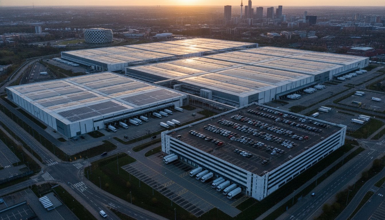
Drone photography for annual reports is the specialized application of professional Unmanned Aerial Vehicles (UAVs) to capture high-resolution imagery and cinematic video of corporate assets, large-scale projects, and personnel. While the history of aerial photography spans over a century, its role in 2026 has transitioned from a simple “obligatory record” into a sophisticated tool for brand storytelling. In a market where corporate transparency is a primary driver of investment, these aerial perspectives provide the verifiable evidence that stakeholders demand. It’s no longer enough to state that a project is progressing; you must show it from a perspective that captures its entire footprint.
With the 2026 UK drone regulations now in full effect, including mandatory Remote ID and specific UK class markings for all commercial hardware, the distinction between hobbyist snapshots and professional aerial filming has never been clearer. For UK infrastructure and property sectors, the ability to demonstrate scale is paramount. Whether you’re showcasing a sprawling solar farm or a multi-phase urban development, the view from above offers a psychological “big picture” that ground-level shots can’t replicate. This perspective builds immediate investor confidence by making complex, multi-million-pound investments feel tangible and real.
To better understand how these elevated perspectives can transform your corporate visual strategy, watch this helpful technical overview:
Beyond the Ground: The Aerial Advantage
Traditional photography often fails to encompass the true magnitude of expansive sites, leaving shareholders with a fragmented view of operations. Drones bridge this gap by providing essential context, showing exactly how a facility sits within its local environment or connects to vital transport networks. This isn’t just about documentation. It’s about positioning. By utilizing advanced UAV technology, a brand signals its commitment to modernism and technological adoption. It shows that the company isn’t just growing, but is doing so with the precision and oversight that only professional drone photography for annual reports can provide.
The Role of Visuals in 2026 Investor Relations
High-quality aerial imagery serves a critical function in reducing the “cognitive load” associated with dense financial statements. When a reader can see a clear, high-resolution visual of a remote asset or a complex construction milestone, the data on the page becomes significantly more accessible. In 2026, the expectation for consistent visual quality across both digital and print report versions is non-negotiable. Using drones to create a tangible feel for assets that investors may never visit in person bridges the gap between abstract figures and physical reality, ensuring your corporate narrative remains grounded in visible success.
Strategic Shots: Key Aerial Perspectives for Stakeholders
Selecting the right visual perspectives is a technical and strategic decision that directly impacts how shareholders perceive your company’s health. The “Hero Shot” remains the most critical asset for any report. It’s an iconic, high-altitude image designed for the front cover that signals corporate strength and operational scale. By positioning your primary headquarters or flagship project against an expansive landscape, you provide a sense of stability that ground-level photography simply cannot replicate. This high-end output creates an immediate connection, assuring investors that the business is both grounded and forward-looking.
Beyond the cover, drone photography for annual reports serves as a verifiable record of year-on-year progress. Side-by-side aerial comparisons or time-lapse sequences from fixed GPS coordinates allow stakeholders to witness the evolution of a site over the fiscal year. This level of transparency is essential for infrastructure projects where milestones are often buried in complex technical jargon. Seeing a foundation transition into a completed logistics hub provides a tangible success metric. Many modern businesses now recognize the strategic advantages of drone technology as a primary tool to validate their project timelines and capital expenditure.
Visualising ESG and CSR Initiatives
In 2026, Environmental, Social, and Governance (ESG) reporting is a central pillar of investor relations. Drones provide unique ways to visualize these commitments with total clarity. For instance, PV solar farm thermal surveys can be used within a report to demonstrate the active maintenance and energy efficiency of renewable assets. Aerial views of habitat restoration zones or community project sites offer undeniable proof of a company’s social impact. These shots move beyond vague claims by providing high-resolution evidence of environmental preservation efforts and sustainable infrastructure investments.
Infrastructure and Project Milestones
For industrial and construction sectors, technical precision is just as important as aesthetics. Top-down “plan view” shots provide accurate site documentation that mirrors architectural drawings, making them perfect for internal audits and stakeholder reviews. Meanwhile, low-altitude cinematic orbits can highlight specific design features or technological innovations. By integrating drone survey data, companies can even generate 3D models for digital annual reports, allowing investors to virtually interact with a project site. If you’re looking to capture these complex perspectives safely, our team at Impact Aerial specializes in delivering compliant, high-tier imagery that meets the most rigorous corporate standards.
Navigating UK Compliance: Safety and Insurance Standards
Executing professional drone photography for annual reports isn’t just a creative endeavor; it’s a regulated aviation activity that carries significant legal weight. In the corporate sector, where reputational risk is as critical as physical safety, adhering to the latest Civil Aviation Authority (CAA) standards is non-negotiable. As of January 1, 2026, the UK regulatory framework has fully diverged from previous standards, mandating specific UK class markings (UK1 to UK6) and Remote ID broadcast capabilities for commercial operations. Ensuring your photography provider holds a valid UK drone license and a GVC (General Visual Line of Sight Certificate) is the first step in protecting your organization from significant legal liability.
Insurance remains a cornerstone of corporate risk mitigation. While the legal minimum for commercial third-party liability is £0.75 million, this is often insufficient for high-value industrial sites or congested urban projects. We consider £5 million in commercial liability insurance to be the professional standard for UK corporate photography. This level of coverage provides the psychological comfort and financial security required when operating near expensive infrastructure or public spaces. It ensures that should an incident occur, the financial and legal fallout doesn’t land on your balance sheet. Our commitment to these standards reflects the meticulous approach required for high-tier corporate reporting.
Safety is built on methodical preparation, not luck. A professional operator provides a comprehensive suite of Risk Assessment Method Statements (RAMS) and pre-flight surveys before any hardware leaves the ground. These documents aren’t just paperwork; they’re a technical roadmap for safe operation. They detail how the pilot will manage site-specific hazards, from overhead power lines to personnel movements, ensuring the shoot proceeds without disrupting your daily operations. This level of oversight is what separates a professional service from a casual operator.
Vetting Your Drone Service Provider
When procurement teams vet a drone partner, they must look beyond the portfolio. A robust checklist includes verifying current CAA certifications, checking the validity of EC785/2004 compliant insurance, and confirming the use of enterprise-grade hardware. We utilize DJI Enterprise systems, which offer 4K HDR clarity and enhanced signal reliability compared to consumer models. Hiring “hobbyist” pilots might seem cost-effective, but they lack the necessary legal certifications and industrial-grade safety features, posing a massive reputational risk to your brand if regulations are breached.
Operational Safety in Urban and Industrial Zones
Capturing assets in congested areas like Birmingham or the West Midlands requires advanced coordination. This often involves liaising with local authorities and Air Traffic Control (ATC) to secure permissions for restricted airspace. Professional pilots manage these complexities by using green flashing anti-collision lights for night operations and broadcasting Remote ID as required by 2026 laws. This methodical approach allows us to capture stunning visuals in the heart of industrial hubs while maintaining the highest possible safety standards for your staff and the public.
Maximising Visual ROI: Integrating Drone Imagery into Your Report
Securing high-tier aerial imagery is only the first stage of the process. To truly maximise your return on investment, you must integrate these assets strategically within your report’s layout. Wide-angle aerial shots are exceptionally effective when used as section breaks or double-page spreads, providing a visual “breather” between data-heavy pages. By applying professional colour grading that aligns with your corporate brand guidelines, we ensure that every aerial asset feels like a native part of the document rather than a generic stock image. This meticulous attention to post-production detail maintains a cohesive brand identity throughout the statutory filing.
One of the most effective ways to use drone photography for annual reports in 2026 is through the use of data overlays. By annotating high-resolution aerial shots with key performance indicators (KPIs) or project metrics, you transform a beautiful image into a functional data tool. For example, an aerial view of a logistics hub can be overlaid with throughput statistics or expansion percentages. This approach allows stakeholders to digest complex information quickly, as the visual context provides an immediate anchor for the numerical data. It’s a sophisticated method of storytelling that bridges the gap between the boardroom and the field.
Designing for Digital and Print
Professional output requires a dual-track approach to resolution and formatting. High-end lithographic printing demands a minimum of 300 DPI at the final output size to maintain crispness. Conversely, digital annual reports benefit from cinematic drone loops and 4K video backgrounds that bring the document to life on a screen. We also recommend creating short social media teasers from drone B-roll to build anticipation for the report’s official launch. This multi-channel utility ensures that your investment in aerial filming works harder across all corporate communications.
The Narrative Flow: From Sky to Boardroom
A well-structured report uses a wide-to-tight sequence to guide the reader’s eye from the broad corporate vision down to specific operational successes. While our drone photography guide covers the technicalities of capture, the implementation phase is where the brand narrative truly takes shape. Integrating these expansive views with executive headshots and ground-level team photos creates a balanced, human-centric story of growth. If you are ready to transform your 2026 reporting with precision-engineered visuals, contact Impact Aerial to discuss our specialist post-production and filming services.
Partnering with Impact Aerial for Your 2026 Annual Report
Choosing a technical partner for your corporate reporting is a decision that balances creative vision with rigorous risk management. Impact Aerial doesn’t operate as a simple photography agency; we act as a specialized technical consultancy. We understand that utilizing professional drone photography for annual reports requires a deep appreciation for the high stakes of corporate compliance and investor relations. Our team brings a wealth of experience in delivering high-tier drone services across the UK, ensuring that your most critical statutory documents are supported by imagery that projects authority and scale.
Based in Birmingham, our central location allows us to deploy rapidly to corporate sites and infrastructure projects nationwide. This geographical advantage is paired with a methodical, consultative workflow. We guide your team from the initial concept and airspace feasibility checks through to the final post-production stages. By handling the complex logistics of CAA authorizations and site-specific safety protocols, we allow your marketing and IR teams to focus on the narrative while we secure the visual evidence. Our commitment to the highest safety and quality standards in the industry ensures that your shoot is seamless, safe, and fully compliant with 2026 regulations.
Our Technical Expertise
We utilize commercial-grade DJI Enterprise hardware to ensure unmatched image stability and 4K HDR quality, even in challenging industrial environments. This professional-grade equipment is essential for capturing the fine details required for high-resolution print and interactive digital reports. Our post-production capabilities are equally rigorous. We provide meticulous colour grading and retouching to ensure your assets are “boardroom ready” and perfectly aligned with your corporate brand guidelines. Whether your assets are in the property, construction, or energy sectors, we have the sectoral experience to highlight your operational strengths from the most impactful perspectives.
Start Your Project Consultation
Success in the annual reporting season depends on early preparation and clear communication. Our specialized approach to drone photography for annual reports involves working closely with your team to identify the key visual assets that will resonate most with your stakeholders. Because the reporting window is often tight and weather-dependent, we strongly recommend early booking to secure your required flight dates. Contact Impact Aerial today for a bespoke quote and a comprehensive safety consultation. Let’s discuss how our technical precision and aerial expertise can elevate your corporate transparency and build lasting investor trust for 2026.
Elevate Your Stakeholder Communications with Precision
Statutory reporting in 2026 demands more than just transparency; it requires a compelling visual narrative that justifies your corporate scale. By moving beyond static ground-level shots, you provide investors with a verifiable perspective of your infrastructure and ESG progress. We’ve explored how the strategic application of drone photography for annual reports bridges the gap between complex financial data and tangible operational success. This approach ensures your brand narrative remains grounded in physical reality while projecting a forward-thinking, technologically adept image to the market.
Success depends on more than just high-resolution imagery. It requires a partner who prioritizes safety and rigorous regulatory compliance. Our Birmingham-based team provides UK-wide coverage, utilizing CAA GVC certified pilots and maintaining £5m in commercial liability insurance to protect your reputation and assets. Don’t leave your corporate image to chance with non-compliant operators who lack the necessary technical credentials. Request a bespoke quote for your annual report photography from Impact Aerial today and ensure your 2026 filings set a new standard for corporate excellence. We’re ready to help you showcase the true reach and impact of your organization.
Frequently Asked Questions
Do I need special permission to fly a drone over my company’s site for an annual report?
Yes, you generally need permission from the land owner to take off and land on private property. If your corporate site is located within a Flight Restriction Zone (FRZ) or a congested urban area, the pilot must also coordinate with Air Traffic Control or local authorities. A professional operator handles these complex logistics and permissions as part of the standard pre-flight planning process.
How much does professional drone photography for a corporate report cost?
The investment for professional aerial services depends on several technical variables, including the site’s location, the duration of the flight, and the complexity of the required shots. Projects involving multiple regional sites or advanced post-production will require a different scope than a single-site “hero shot.” We provide bespoke quotes tailored to the specific technical requirements of your project.
What happens if the weather is bad on the day of the scheduled drone shoot?
Safety is our primary concern, and we don’t operate in high winds or precipitation that exceeds the hardware’s safety limits. We monitor meteorological forecasts closely in the days leading up to your shoot. If conditions are unsafe for flight, we’ll coordinate with your team to reschedule for the next available clear-weather window to ensure the highest image quality.
Can drone photography be used to show internal factory or warehouse operations?
Yes, we can capture internal operations using specialized indoor flight protocols and smaller, guarded UAVs. This is an effective way to demonstrate the scale of automated logistics or manufacturing lines. Indoor flight requires meticulous planning to manage lighting challenges and ensure the total safety of your personnel and sensitive equipment throughout the process.
What is the difference between a standard drone photo and a survey-grade aerial image?
A standard drone photo is an aesthetic asset designed for visual storytelling and brand narrative. In contrast, a survey-grade image is a data-centric asset captured with high-precision GPS for 2D mapping or 3D modeling. While standard shots are ideal for report covers, survey-grade imagery provides the technical accuracy needed for detailed infrastructure progress and site documentation.
Is drone photography compliant with GDPR if people are visible in the shots?
Professional drone photography for annual reports must comply with GDPR if individuals are identifiable in the captured imagery. We employ “privacy by design” by flying at altitudes where faces aren’t recognizable or by blurring identifiable features during post-production. It’s also standard practice for companies to inform employees of the shoot date so they can avoid the flight area.
How long does the post-production process take for aerial images?
The post-production phase typically takes between three to five business days depending on the volume of assets and the complexity of the editing. This process includes professional colour grading, retouching to match your corporate brand guidelines, and any required data overlays. We understand the tight deadlines of the reporting season and ensure your visuals are boardroom-ready on schedule.
Why is £5m liability insurance necessary for a simple drone photo shoot?
While the legal minimum is lower, £5 million in commercial liability insurance is the professional standard for corporate environments. This level of coverage protects your organization against the significant financial risks associated with operating near high-value industrial assets or public spaces. It provides the necessary reassurance that all operational risks are fully mitigated by your service provider.
