
Can a drone image show what happened on a construction site, or only what it looked like from above? When work changes, a clear aerial record can help examine progress, site conditions and the sequence of events. Drone data for construction dispute resolution is most useful when it addresses a defined question and preserves the context of each capture.
When photographs, reports and recollections don’t line up, a reliable visual record can help clarify what was visible on site. But imagery alone doesn’t settle a dispute. Its value depends on when and where it was captured, how it was processed and how it compares with other project records. Measurements also need to be understood in light of the equipment, survey control and method used.
This guide explains which dispute questions drone records may help investigate, what to document before, during and after a flight, and how to preserve and compare the resulting material. It also covers the limits of aerial imagery and measurement, and the role of appropriate expert evidence. With a consistent capture workflow, construction site monitoring can contribute a clearer, better-contextualised record to the wider project evidence set.
Key Takeaways
- Use drone records to examine visible site conditions, progress, access and sequencing at a particular point in time.
- Start with the disputed issue, then plan where and when to capture material that can help address it.
- Understand how imagery, photogrammetry, LiDAR, survey data and project records answer different questions, with different limitations.
- Assess drone data for relevance, completeness, processing transparency and corroboration. A polished visualisation alone isn’t enough.
- Drone data for construction dispute resolution is most useful when professional capture and clear records support the wider project evidence and review.
How drone data can clarify a construction dispute
Drone data for construction dispute resolution includes recorded aerial imagery and survey outputs considered alongside other project evidence. It can show visible site conditions at a particular time, helping investigators compare what was present with programme records, drawings or accounts of events. Its purpose is to clarify the evidence, not replace it.
Depending on the capture plan, records may include overview photographs, repeat imagery from different dates, mapped outputs or annotated views that highlight a particular area. Mapped information can also be considered alongside digital project material, including Building Information Modeling (BIM). Each format offers a different way to review a site, but none is self-explanatory.
A contemporaneous site record shows what was visible at a particular time. It does not, by itself, establish why something happened or who was responsible. Imagery can inform an investigation, but it doesn’t independently determine fault, causation or legal liability.
Which construction disputes may benefit from an aerial record?
An aerial record may help examine disagreements about visible progress, alleged damage, access constraints or changes to site conditions. For example, repeat captures can help compare the visible state of a work area across dates. An overview may show routes or obstructions relevant to an access issue. The record is useful only if the disputed feature can be seen from a safe aerial viewpoint. Footage can document what was visible, but not necessarily why a change occurred or which party caused it.
What can drone imagery show, and what can it not prove?
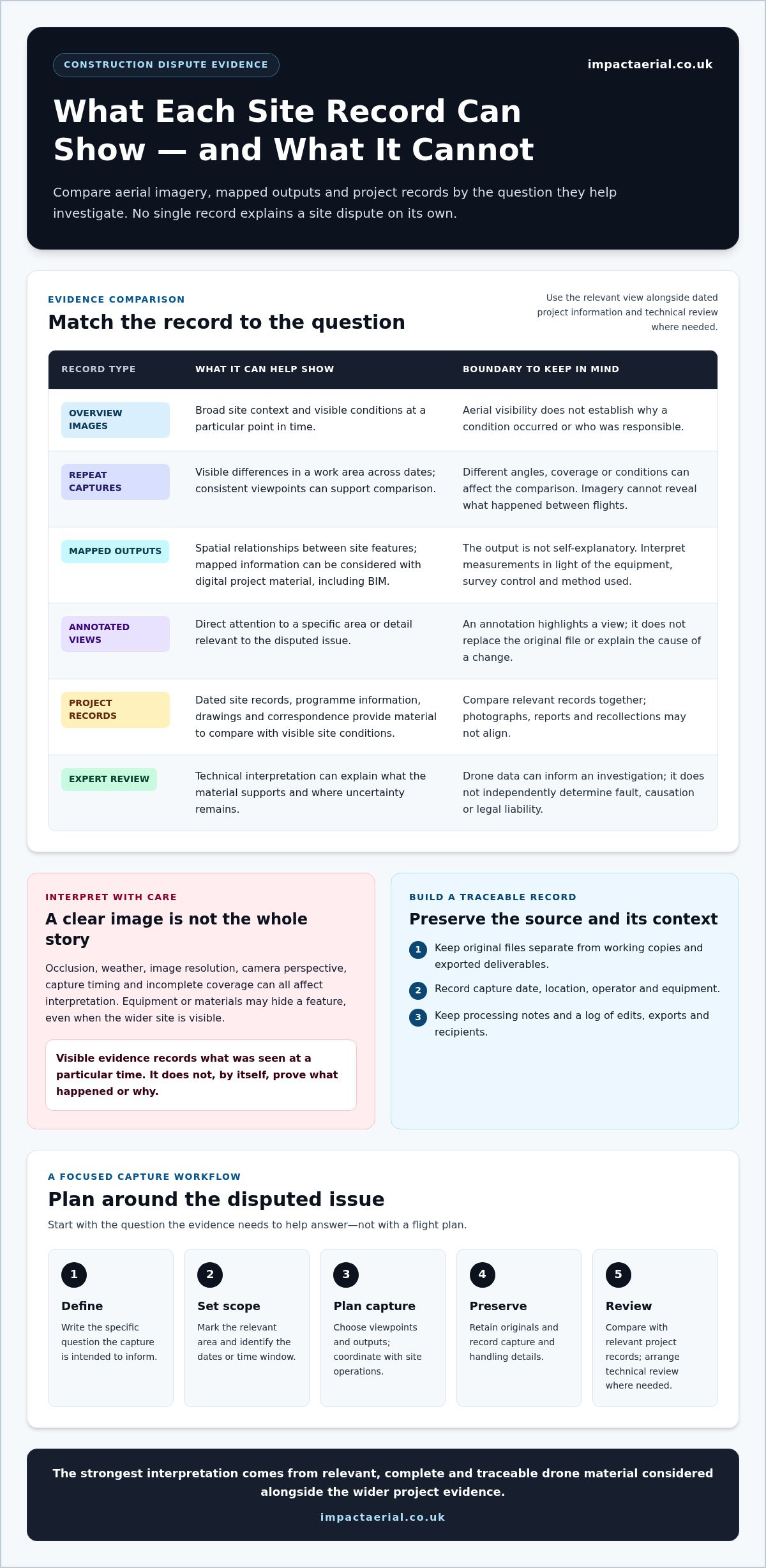
Overview images show broad context; repeat captures show visible differences over time; mapped outputs relate features spatially; and annotated views direct attention to specific details. Which is useful depends on the question and on how the material was captured and prepared.
Occlusion, weather, image resolution, camera perspective, capture timing and incomplete coverage can all affect interpretation. Equipment or materials may hide a feature, even when the wider site is visible. An image also won’t reveal what happened between flights. Interpret measurements in light of the method and its limitations rather than assuming they are accurate based on appearance alone.
For a balanced assessment, compare imagery with dated site records, drawings, correspondence and other relevant project information. Where technical interpretation is needed, expert analysis can explain what the material supports and where uncertainty remains. This comparison helps distinguish visible observations from conclusions about cause or responsibility.
How to plan drone data collection around the disputed issue
Begin with the question the evidence needs to help answer, not with a flight plan. A focused brief helps the capture team select suitable viewpoints and outputs, and reduces the risk of collecting attractive but irrelevant material. For drone data for construction dispute resolution, define the issue and intended use before deciding what to record.
Build a capture brief around the question in dispute
Identify the feature in question, the relevant site boundary, the dates or time window, and who will review the output. Decide whether the task calls for contextual imagery, repeat monitoring, mapping or a survey-oriented deliverable. Note access constraints, active works, hazards and coordination needed with the site team. The RICS professional standard for aerial surveys can inform planning for aerial survey work.
Use this practical sequence:
- Define the issue: Write the specific question the capture is intended to inform.
- Set the place and time: Mark the relevant area and identify the dates or period that matter.
- Plan the capture: Choose appropriate viewpoints and outputs, and coordinate with site operations.
- Preserve the files: Retain original data and record capture and handling details.
- Review in context: Compare the output with relevant project records and arrange technical review where needed.
For later comparison, plan repeat captures from consistent viewpoints where practical. Record timestamps, location references and capture notes, including any changes to the planned coverage. These details help reviewers distinguish an actual site change from differences in angle, coverage or conditions.
Preserve the original data and capture context
Keep original files separate from working copies, annotated images and exported deliverables. Record the capture date, location, operator and equipment, along with processing steps where available. Maintain a file-handling log showing edits, exports and who received each version. This makes it easier to trace a presented image back to its source and understand how it was prepared.
At minimum, retain the original files, capture date and location, operator and equipment details, processing notes, and a record of edits, exports and recipients.
Agree how the material will be stored and shared, and ensure the responsible project professionals follow applicable evidence protocols and legal requirements. Impact Aerial’s construction site monitoring and drone data collection surveys support planned capture with project-specific coordination.
Comparing drone imagery, mapping, and conventional construction records
No single record answers every dispute question. Photographs show visible context, mapped outputs can help locate features, and conventional survey or project records may provide information that aerial views cannot. The value of drone data for construction dispute resolution depends on matching the source to the question, then interpreting it alongside relevant evidence.
| Source | Question it can help answer | Useful output | Principal limitation |
|---|---|---|---|
| Visual imagery | What was visibly present in an area at capture time? | Overview photographs or repeat views | Perspective, resolution, weather and occlusion can obscure detail or affect comparison. |
| Photogrammetry | Where do visible features appear across a wider site? | Orthomosaic, 3D model or point cloud derived from overlapping images | Results depend on image coverage, surface conditions, control and processing. |
| LiDAR | What surface geometry was recorded from the sensor’s viewpoint? | Point cloud or derived surface representation | Line of sight, occlusion, sensor setup and processing affect what is captured and represented. |
| GNSS or total-station data | Where are specified points relative to the project’s survey control? | Surveyed coordinates or measured points | Coverage is targeted, and interpretation depends on the survey method and project requirements. |
| Site records | What was reported, instructed, planned or observed? | Diaries, drawings, programme records, inspection notes and correspondence | Records may be incomplete, inconsistent in timing, or describe events rather than independently verify site conditions. |
When are photographs, orthomosaics, or 3D models useful?
Photographs provide a direct visual view of site context. An orthomosaic combines images into a map-like view that can help locate visible features across an area, while a 3D model supports visual review from different angles. Neither format guarantees reliable measurement. Perspective, occlusion, surface conditions, image coverage and missing control can limit what can safely be measured or concluded.
When should drone outputs be checked against other records?
Compare aerial outputs with dated site diaries, drawings, programme records, inspection notes and correspondence to test whether the material supports the same timeline and interpretation. Where controlled positional measurements are required, GNSS or total-station survey data may be more appropriate or provide a useful comparison. Technical interpretation should be handled by suitably qualified survey or legal professionals when it extends beyond the capture team’s role.
Measurement confidence depends on the method, survey control, processing and stated project requirements. A mapped image or point cloud should be accompanied by enough methodological information to show how it was produced and what it can support. No capture method is automatically sufficient to resolve a dispute or admissible in a particular proceeding. Its relevance and weight depend on the wider evidence and applicable process.
How to assess reliability, limitations, and evidential relevance
Start with a clear question: does this material help assess the disputed issue, and can its origin and limitations be understood? Drone data for construction dispute resolution should be evaluated as part of the wider project record, not on visual polish alone. A refined model or annotated image can make information easier to view, but it can’t replace source files or a transparent account of how the output was created.
What makes a drone record more useful to a dispute review?
Check that each output relates to a defined feature, location and time period, and that the capture method is documented. Processing choices, exclusions and known gaps should be clear enough for a reviewer to understand what they are seeing. Consistent file names, version control and secure transfer also help organise the project record and reduce confusion between originals, working files and later exports.
Use this checklist to assess the material:
- Relevance: Does the capture address the disputed feature or question?
- Timing: Is the capture date clear and appropriate to the period being examined?
- Location: Can the relevant area be identified reliably?
- Completeness: Are there gaps, obstructed views or areas outside the coverage?
- Method: Is it clear how the imagery or survey output was captured?
- Processing: Are edits, exclusions and processing steps explained, with source files available?
- Corroboration: Does the material align with relevant project records, or is there an explanation for differences?
What are the limits of drone evidence in UK disputes?
A drone record may show a visible condition, but it doesn’t by itself establish causation, contractual meaning or legal responsibility. Those are distinct questions that may require other evidence and interpretation from appropriately qualified professionals. A drone operator should not promise that material will be admissible or determine the weight a court or tribunal may give it. Legal teams should consider the current Civil Procedure Rules and any applicable expert-evidence requirements for the specific proceedings.
Practical constraints matter too. Weather, airspace conditions, site access, active works and flight safety can affect when and how a capture is possible, or leave parts of the site undocumented. Record these limits rather than concealing them, so reviewers can judge how they affect the evidence.
Impact Aerial’s construction monitoring and drone data collection support project-specific capture planned around a defined issue.
Using professional drone data collection in a construction dispute workflow
A disciplined workflow connects the disputed issue to a planned capture and an organised handover. Drone data for construction dispute resolution can support an investigation when capture priorities are clear, site activity is coordinated and the resulting material can be reviewed alongside the wider project record. It doesn’t guarantee a particular legal outcome or evidential acceptance.
From project question to organised drone deliverables
Start by scoping the disputed area, relevant dates, site access and safety considerations. Then agree what the capture needs to document and which outputs will be useful for review. A visible condition might call for contextual imagery; comparison across dates may require repeat monitoring; a spatial question may call for mapping. Impact Aerial’s construction monitoring and drone data collection services support this capture stage, using CAA GVC certified pilots and commercial-grade professional drones with high-resolution 4K HDR cameras.
A practical sequence helps keep the work focused:
- Define the issue: Specify the site feature and question the capture is intended to inform.
- Coordinate on site: Align access, timing and capture priorities with the project team and planned works.
- Capture the agreed scope: Collect suitable imagery or survey outputs for the defined area and purpose.
- Organise the handover: Clearly identify deliverables and preserve relevant capture context.
- Review with project evidence: Compare the material with records and involve appropriate professionals for interpretation.
For a fuller overview of methods and outputs, see Drone Survey: The Complete Guide to Aerial Data Collection. Choose the capture plan to suit the project question, rather than defaulting to the most complex output available.
Coordinate capture with the wider project record
Capture dates are more useful when they can be compared with site diaries, inspections, programme milestones and relevant project documents. Share the planned scope with the people coordinating site activity, so important areas can be recorded safely and the timing can be understood later. Impact Aerial provides UK-wide drone data collection from a Birmingham and West Midlands base, with £5m commercial liability insurance.
After delivery, survey professionals can assess technical questions about the data, while legal professionals can consider its relevance within the dispute. Impact Aerial provides planned construction capture and organised drone outputs. The company does not determine liability or promise that material will be accepted as evidence.
When planning a capture, align the site, timing and required outputs with the issue under review.
Build a clearer site record for your project
Drone data for construction dispute resolution is most useful when it addresses a defined question, captures the relevant place and time, and is reviewed alongside project records. Aerial imagery and survey outputs can help clarify visible conditions or changes, but their limits matter: they don’t establish fault or replace appropriate survey and legal expertise.
A planned workflow helps preserve context, from coordinating capture around site activity to retaining original files and documenting how outputs were prepared. Impact Aerial supports UK construction projects with construction site monitoring and drone data collection, using CAA GVC certified pilots and commercial-grade DJI Enterprise drones. The service is backed by £5m commercial liability insurance.
Discuss a construction drone data capture plan with Impact Aerial to explore how a project-specific record could support your wider evidence set. With a clear question and carefully planned capture, you can take a more organised approach to investigating site conditions.
Frequently Asked Questions
Can drone footage be used as evidence in a construction dispute?
Drone footage may help document visible site conditions, but whether it can be relied on in a particular dispute depends on its relevance, timing, authenticity, context and interpretation. Preserve the original files and related project records so the material can be traced and assessed. Footage doesn’t automatically prove responsibility or liability. Legal teams should consider admissibility and evidential weight in light of the applicable proceedings.
What drone data is most useful for a construction claim?
The most useful output depends on the claim and the question being investigated. Dated photographs may show visible conditions, while mapped imagery or 3D outputs can help locate features or review change across a site. Survey-oriented measurements may need suitable control and validation. Define the issue before selecting a capture method, then compare the output with project records and arrange appropriate professional analysis. This is how drone data for construction dispute resolution can support, rather than replace, the wider evidence.
How can drone surveys document construction site conditions over time?
A planned series of captures can record selected areas at relevant project stages. Consistent viewpoints, clear capture dates and location references make later comparisons easier to review. Keep files organised and note any changes in coverage or capture conditions. Weather, access, active works and visibility can affect what is recorded, so document limitations rather than implying every site detail was observed. Compare the imagery with dated project records to understand its context.
Are drone measurements accurate enough for a construction dispute?
Accuracy depends on the capture method, equipment, survey control, processing and the project’s stated requirements. A drone image alone doesn’t establish survey-grade accuracy, and a measurement displayed on a model shouldn’t be relied on without understanding how it was produced. Review the deliverable’s methodology and limitations. Where a measurement is critical, compare it with appropriate survey data or have it assessed by a suitably qualified professional before drawing conclusions.
What records should be kept with drone data for a dispute?
Keep the original files and, where available, record the capture date, location, operator, equipment and processing steps. Track edits, exports, versions and transfers so reviewers can understand how a file was handled and identify the source material. Preserve related site records, such as diaries, drawings or inspection notes, that help explain what the imagery shows. Follow the project’s evidence-handling procedures and account for any legal requirements that may apply to formal proceedings or disclosure.
Can drone data prove who caused construction damage?
Drone data can help show the visible condition of an area at a particular time, especially when compared with earlier records. On its own, however, it generally can’t establish when damage occurred, what caused it or who was responsible. Those conclusions may require a reliable chronology, site documentation, technical inspection and expert or legal interpretation. Treat aerial records as one part of the evidence, not as a standalone finding of liability.
 2 Norton Drive, Wythall, Birmingham, B47 6HH Company registration number: 11138586. VAT Number: 366 9068 55


