
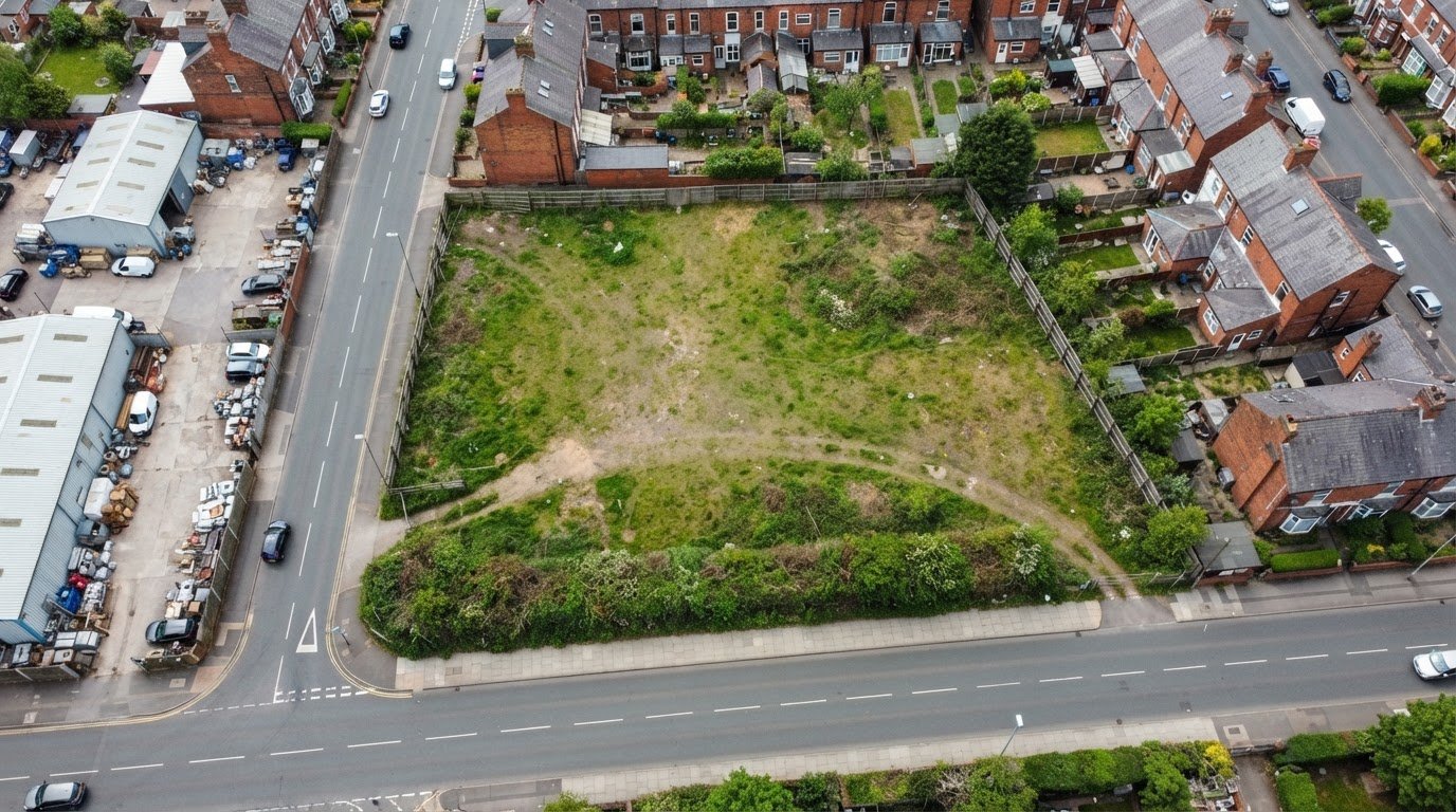
The most useful aerial photograph is not simply the newest one; it is an image that clearly covers the relevant land and its surroundings at a useful point in time. Aerial photography for a compulsory purchase order can be researched by location, date and image extent, then assessed for whether the vertical view shows the property and nearby features needed for the matter. The search itself is free, although a supplier may pass on a fee for supplying photographs.
Clear visual evidence can help people understand land acquisition proposals. The challenge is finding imagery that is both relevant and legible, rather than relying on a view that misses part of the site or lacks context. This guide explains how to assess aerial photographs, what vertical coverage can and cannot show, and which practical details affect an image’s suitability. It also explains how professional aerial photography can support a CPO project when existing coverage does not show what is needed.
Key Takeaways
- Learn how a professional search can narrow aerial-photo coverage by location, date and relevance to the land involved.
- Understand how vertical images are assessed for clarity, site boundaries and surrounding features.
- See what aerial photographs may help show in a compulsory purchase inquiry, and where their evidential value has limits.
- Find out which UK drone-operating considerations matter when capturing new imagery near a CPO site.
Professional Aerial Photo Search for Compulsory Purchase
A professional search matches the land boundary and relevant dates to available aerial coverage. The statutory process also matters: UK Parliament states that the compulsory purchase framework and procedures are set out in the Compulsory Purchase Act 1965.
Comparing Aerial, Satellite and Ground Surveys
Aerial photographs show site layout from above, while satellite imagery covers broader areas and ground surveys record details at the location. For a CPO, compare the method with the question being examined, such as how a track meets a field boundary or how a building relates to surrounding land.
Narrow a search by address or mapped boundary, image date and required coverage. Check that the photograph is dated. Georeferencing can help align an image with mapped land, while independent verification may be relevant if authenticity or interpretation is disputed. No single image type replaces every ground observation.
Rules for Aerial Surveys
Aerial surveys must account for applicable aviation, site-access, planning and local-authority constraints. Requirements depend on the location and proposed operation, so plan the survey around the site, access arrangements and intended imagery before capture.
For entry to survey land in England, UK Parliament states that under section 174 of the Housing and Planning Act 2016, an acquiring authority must give every owner or occupier at least 14 days’ notice before its first intended entry under section 172. Separately, the Ministry of Housing, Communities and Local Government states that an English CPO notice must allow at least 21 days for objections. These are distinct statutory notice requirements.
Privacy planning matters too: capture only relevant views, avoid unnecessary images of identifiable people or private activity, and control access to image files.
Evidence of Land and Property Conditions
Vertical photographs can show visible land use, access routes, structures, boundaries and nearby features at the time of capture. At an inquiry, these details may help explain the site’s physical context, but an image alone cannot establish ownership, legal boundaries or events outside its view.
For a before-and-after record, professionals compare images with consistent coverage and clearly recorded dates, noting visible changes such as a removed structure or altered access. The Compulsory Purchase Act 1965 provides the statutory framework, while evidence should be tied to the particular issue under consideration.
Financial evidence has separate requirements: UK Parliament states that, in England, an acquiring authority must pay 90 per cent of agreed compensation or its estimate, subject to receiving a valid advance-payment claim. Aerial imagery may illustrate land condition, not calculate that payment.
Commissioning Surveys and Assessing Limitations
To commission a survey, provide the acquiring authority’s site plan or boundary, the relevant parcels, the dates or changes of interest, and the intended evidential purpose. A professional can then define coverage, capture timing and deliverables. In England, UK Parliament states that an application under section 23 of the Acquisition of Land Act 1981 must be made within 6 weeks of the date specified in section 23(4).
Shadows, vegetation, resolution, viewing angle and incomplete coverage can limit an image. It records only what was visible at capture. Pairing dated imagery with survey records or ground observations can help address these gaps. In a CPO case, an image’s relevance depends on the issue it is intended to explain.
How a professional assesses vertical aerial photography coverage for a compulsory purchase order
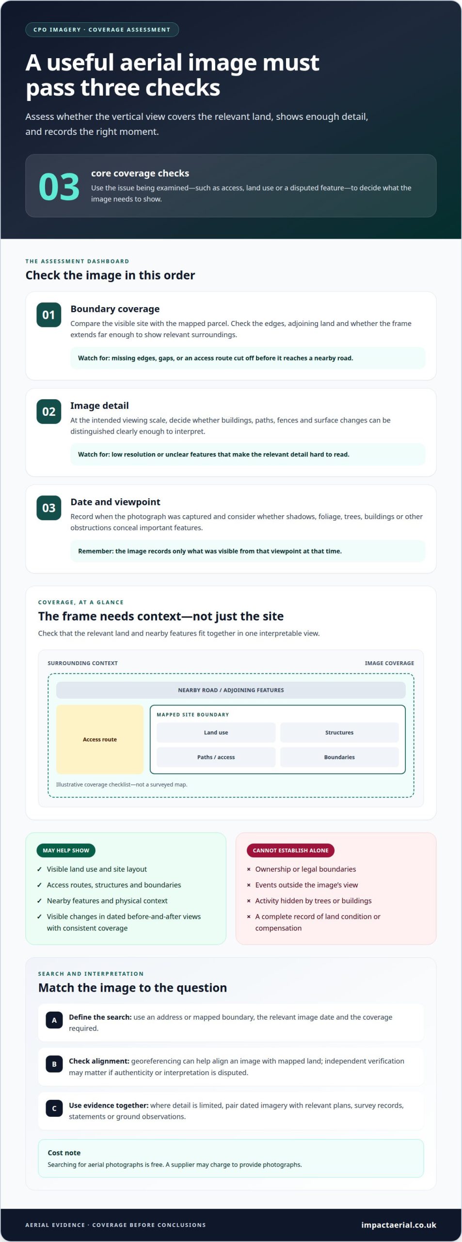
Assess whether vertical images show the full area relevant to the CPO and whether features are clear enough to interpret. Start with the affected land boundary and the purpose of the evidence, such as explaining access, land use or a feature raised in a dispute. This defines what must appear in the frame and what surrounding context could clarify the issue.
Review coverage against the project map or plan. Check whether the image extends beyond the boundary, includes adjoining features and avoids gaps that could obscure a track, structure or change in land use. For example, a photograph that cuts off an access route may not show how the site connects to a nearby road.
- Boundary coverage: Compare the visible site with the mapped parcel, checking edges and adjoining land that may be affected.
- Image detail: Assess whether buildings, paths, fences and surface changes can be distinguished at the intended viewing scale.
- Date and viewpoint: Record when the image was captured and whether shadows, foliage or obstructions conceal relevant features.
The image date and viewpoint help explain what a photograph can establish. A clear vertical view may show a site’s layout, but it cannot by itself prove ownership or reveal activity hidden by trees or buildings. If compensation or land condition is disputed, consider the image alongside relevant plans, statements and other evidence, not as a complete record.
Coverage also applies to the output: the supplied files should make the surveyed area easy to locate and interpret. The assessment identifies missing edges, unclear detail or inconsistent alignment before the images are relied upon. For a new capture, professional aerial photography can provide a planned vertical view aligned with the project’s evidential purpose.
What evidence can aerial photographs provide in a UK compulsory purchase inquiry?
Aerial photographs provide a visual record of land, buildings and surrounding features at the time of capture. In a UK compulsory purchase inquiry, they can help explain how a proposed scheme relates to the existing site, adding spatial context to plans and written statements. Their value is in showing visible conditions, not in deciding legal or compensation questions on their own.
For example, an image can clarify the relationship between a proposed acquisition boundary and a working access route. A sequence of dated photographs can also show visible changes, such as a new structure, cleared vegetation or an apparently altered route. These comparisons help explain what changed and where, while other evidence addresses why.
- Land use: Show visible fields, yards, buildings or open areas within the scheme footprint.
- Access and layout: Illustrate entrances, tracks, parking areas and connections to nearby roads.
- Site context: Place affected parcels alongside adjoining development, boundaries or physical features.
- Visible change: Compare dated images to identify differences in structures, surfaces or vegetation.
For a partial acquisition, an overhead view can illustrate the land proposed for acquisition in relation to the remainder. It can also show features near the boundary, such as a building close to a new route. This visual context can help an inquiry understand how the project affects the site’s layout, without quantifying the effect on property value.
Photographs do not establish ownership, legal title, precise boundary rights or land value. A single overhead image also cannot reveal a building’s internal condition, underground services or activity hidden by trees. Those issues need other evidence. A clear presentation identifies the capture date, location and relevant parcel, then links each image to the point it supports.
Used this way, aerial evidence helps readers interpret the site without expecting an image to answer every question. A plan can identify the acquisition line, while a photograph shows visible features around it. Together, they can explain the physical setting of a CPO proposal more clearly than either document alone.
What rules apply to drone photography near CPO sites in the UK?
A CPO survey and a drone flight involve separate planning considerations. A notice or authority to survey land does not, by itself, describe a proposed flight, aircraft or capture area. The operator plans aerial work around the site, intended images and conditions on the day.
Before capture, assess the proposed route and nearby surroundings. A site beside a road, occupied property or active construction area presents different operational conditions from an open field. The flight plan should identify the intended take-off and landing area, visible boundary and nearby activity that could affect safe capture.
- Location: Review the site position and surrounding airspace constraints before planning a flight.
- People and property: Consider who may be present and how the operation can avoid unnecessary disturbance.
- Purpose: Define the images needed, such as a vertical view of a parcel or its access route.
- Conditions: Assess visibility, weather and site activity when deciding whether capture can proceed safely.
Privacy deserves attention at CPO sites, where nearby homes or identifiable people may enter the frame. Focus the capture plan on relevant land and avoid collecting unrelated imagery where practicable. Control image handling too, retaining and sharing files for the stated project purpose.
The project team should distinguish evidence needs from flight planning. For example, a request to document a boundary does not automatically require views into neighbouring gardens or occupied buildings.
Because site conditions and the required coverage vary, a professional can plan the capture around the CPO parcel and its intended evidential use. Arrange professional aerial photography for a project that needs carefully planned imagery.
Impact Aerial: Aerial Filming and Photography
Impact Aerial provides Aerial Filming and Photography for projects that need clearly planned new views of land and its surroundings. This can help when existing imagery does not show the relevant area or a project needs a visual record captured for a defined purpose.
For a compulsory purchase scheme, set out the land, boundaries, features and views of interest in the brief. These details help shape coverage so the resulting images suit the site, rather than providing a generic aerial overview. Impact Aerial also provides Drone Commercial Property Surveys and Construction Site Monitoring for related project needs.
If new aerial imagery would support your project, contact Impact Aerial to discuss the coverage you need.
Plan imagery around the decision ahead
Connect the image requirement to the question the CPO project needs to address. A concise project brief can identify the land, relevant date or change, and intended use of the images. This gives the aerial team a clear basis for planning coverage and selecting views suited to the purpose.
For projects with different property or infrastructure needs, Impact Aerial also offers Drone Commercial Property Surveys and PV Solar Farm Thermal Surveys. The right service depends on the site and the information required. Aerial photography for a compulsory purchase order is most useful when its coverage is designed around a specific evidential need, rather than collected without a defined purpose.
Share your project requirements and contact Impact Aerial for advice on suitable aerial coverage. A clear brief is a practical starting point for planning imagery with confidence.
Frequently Asked Questions
What advice do I need?
First identify whether your concern is the proposed land, visible site condition or compensation. These are different issues and need different supporting information. For example, if a boundary dispute concerns an access track, a dated aerial view may help show its physical position, while ownership and compensation require other records. Set out the issue and intended use before commissioning imagery.
What is compulsory purchase?
Compulsory purchase is a process through which a public body can acquire land or property without the owner’s consent for development in the public interest. It is generally used as a last resort, after reasonable steps to agree an acquisition. For a property owner, the practical impact depends on which land is affected and how the acquiring authority intends to use its powers.
How is aerial photography used in a compulsory purchase order (CPO) process in the UK?
Aerial photography for a compulsory purchase order can provide a visual record of a site for project planning or inquiry evidence. For example, a vertical image may help illustrate the relationship between a proposed route, a building and nearby access. It supports an explanation of visible conditions; it does not establish title, decide whether a CPO is justified or calculate compensation.
 2 Norton Drive, Wythall, Birmingham, B47 6HH Company registration number: 11138586. VAT Number: 366 9068 55


