
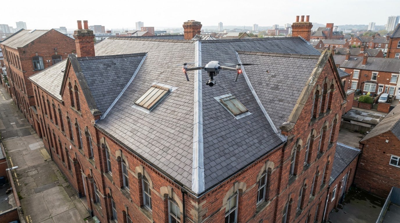
A roof can be measured from drone imagery without putting an inspector on its surface. To understand how to measure a roof with a drone in the UK, the key is capturing clear images from multiple angles so they can be processed into measurements, roof areas and, where required, a 3D model.
It’s understandable to want reliable roof dimensions without the disruption of direct access. A drone survey captures visible surfaces from above and can inform planning, maintenance or a closer inspection. It does not replace hands-on assessment when physical access or testing is needed.
This guide explains how to measure a roof with a drone in the UK, how aerial imagery supports measurement and what affects the quality and usefulness of the results. It also covers the limits of a visual survey and when professional drone capture can help you make better-informed decisions about a roof.
Key Takeaways
- Drone imagery can help inspect visible roof areas while reducing the need for people to access them directly; some work still requires physical inspection.
- Discover how overlapping aerial images can be processed into roof measurements, surface areas and 3D models.
- Learn what affects the accuracy and usefulness of the results, from image coverage to roof features and the purpose of the survey.
- See when a professional commercial property survey can provide useful aerial evidence for planning and assessing roof work.
Why is a Drone Roof Inspection Important?
The Work at Height Regulations 2005 require work at height to be avoided where there is a reasonable alternative, according to UK legislation. A drone survey captures aerial images of visible roof areas without requiring an inspector to walk across them. It can help document a residential roof before access equipment is considered, but it cannot provide physical access for repairs or testing.
Clear images can reveal visible issues such as displaced tiles, damaged flashing, blocked gutters or cracked coverings. An operator can photograph roof slopes, ridges and junctions from different angles, creating a useful record for maintenance planning. Aerial imagery avoids the need to climb simply to view a roof, but cannot establish the condition of concealed layers.
Thermal imagery records surface temperature patterns, not proof of trapped moisture or insulation defects. A warm or cool patch needs careful interpretation and may require follow-up inspection. For measurement, overlapping aerial images help photogrammetry match details across frames and build a coherent roof model. Gaps or blurred images can weaken the result.
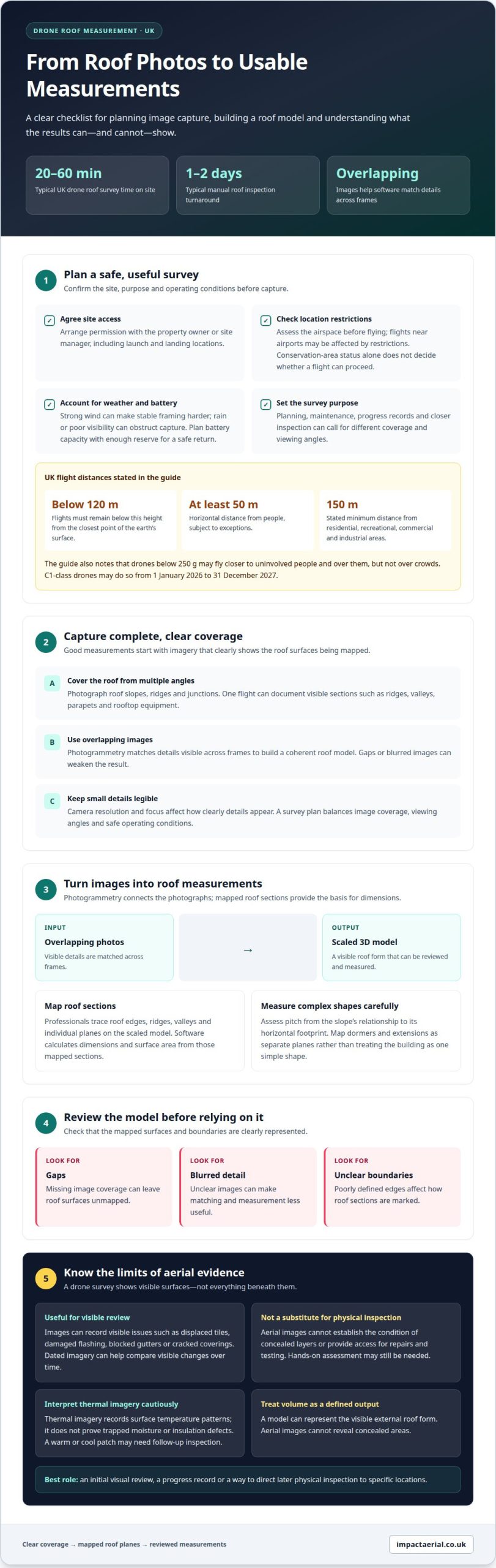
UK drone flights must remain below 120 metres from the closest point of the earth’s surface. Operators must keep at least 50 metres horizontally from people, subject to exceptions. Drones below 250 grams may fly closer to uninvolved people and over them, but not over crowds. C1-class drones may do so from 1 January 2026 until 31 December 2027. The stated minimum distance from residential, recreational, commercial and industrial areas is 150 metres.
Flight-distance rules are separate from site access. Before a commissioned survey, arrange access and agreement with the property owner or site manager, including where the drone may launch and land.
Weather affects both safe flight and image quality: strong wind can make stable framing harder, while rain or poor visibility can obstruct capture. The operator plans battery capacity with enough reserve for a safe return. Some commercial drones fly for over 30 minutes, and flights lasting over 20 minutes make battery life a planning consideration.
Camera resolution and focus affect how clearly small details appear in each image. A professional survey plan balances image coverage, viewing angles and safe operating conditions. Physical access may still be needed for repairs, testing or areas that aerial images cannot show adequately.
Benefits over traditional roof inspections
A traditional roof inspection may require a ladder, scaffold or mobile elevating work platform. A drone can capture external images without placing an inspector on the roof, making it useful when an initial visual review can guide the next decision. It does not provide hands-on access, so roofing repairs and physical tests still require an appropriate access method.
Time on site can also be more focused. A UK drone roof survey usually takes 20 to 60 minutes on site, depending on the building and capture requirements. A manual roof inspection typically has a 1-2 day turnaround. For property managers, that difference can help inform when to arrange maintenance planning or further assessment.
One flight can document several visible roof sections, including ridges, valleys, parapets and rooftop equipment. On an industrial building, that overview can help teams locate areas for closer examination and coordinate access around operational needs. Dated images also create a visual record for comparison with later inspections, helping teams track visible changes rather than rely only on written observations.
Drone imagery may support an insurance assessment by recording visible conditions after an incident. Insurers or loss adjusters determine what evidence they require, and a flight does not guarantee cover or settlement. Clear images of the affected area from useful angles are more practical than distant overview shots alone.
Traditional access remains valuable when a roofing specialist needs to touch materials, test a suspected defect or carry out repairs. A drone inspection is most useful as an initial review, a progress record or a way to direct later access to specific locations. This distinction helps teams choose the right method instead of treating aerial imagery as a complete substitute.
For larger sites, a documented flight plan can organise coverage by roof section and keep image capture consistent. The result is a more useful record for maintenance discussions, future comparisons and decisions about where physical inspection is needed.
On-screen measurements, areas and volumes
Drone photographs can be processed into scaled roof models, measurements, surface areas and three-dimensional views. For UK property teams, how to measure a roof with a drone depends on image coverage, scale and clearly marked boundaries.
Software and 3D Roof Models
Photogrammetry software aligns overlapping drone photos by matching details visible across frames. It can reconstruct roof surfaces as a 3D model, which professionals use to mark edges and calculate dimensions. The software’s output is only useful when the images clearly cover the surfaces being mapped, so review the model for gaps, blurred details and poorly defined boundaries.
Flights near airports may be affected by airspace restrictions, so operators must assess the location before flying. Conservation-area status alone does not determine whether a flight can proceed; site conditions and applicable restrictions also matter.
Roof Area, Pitch and Dimensions
Professionals trace roof edges, ridges, valleys and individual planes on the scaled model. The software calculates dimensions and surface area from those mapped sections. Pitch is assessed from the slope’s relationship to its horizontal footprint. For roofs with dormers or extensions, mapping the planes separately helps avoid treating the whole building as one simple shape.
Volume needs a clear definition. A model can represent the visible external roof form, but aerial images cannot reveal concealed structural depth. A useful report distinguishes individual slope areas, total roof surface and any estimated enclosed volume. This makes the measurements clearer when planning material quantities or discussing a repair quote.
Before figures are used for a quote or repair, the professional reviews image coverage, model scale and marked boundaries. They can compare dimensions with available plans or known site measurements, then identify obscured areas that need further capture. This is how to measure a roof with a drone in the UK while making the scope and limits of the results clear. A precise-looking model alone does not establish structural condition.
Drone-based roof measurement
A professional drone survey turns aerial photographs into mapped roof dimensions and a report. The measurements can inform planning, but their reliability depends on the coverage and quality of the images captured.
Measurement from Drone Imagery
The operator captures overlapping views of each roof plane, including edges, ridges, valleys and features such as dormers. Photogrammetry software matches details across images to build a scaled model. From that model, the operator marks boundaries and calculates dimensions for separate sections, rather than treating a complex roof as one flat shape.
Height, camera angle and obstructions affect which surfaces are visible. If a chimney hides part of a slope, the report should distinguish observed geometry from areas that were not captured clearly. Thermal imagery is a separate data type: it records surface temperature patterns, not roof dimensions or proof of a defect.
Comparing Drone and Manual Accuracy
Drone measurements can be accurate for visible roof geometry, but they are not automatically more or less accurate than manual measurements. Results depend on image resolution, model scale, overlap and clearly defined roof boundaries. Manual measurement provides direct dimensions at accessible points, while aerial capture can map multiple slopes without walking across them.
For a repair quote, the report should identify the measured areas and explain its scope. When preparing for major domestic or commercial projects, specialists like ace-roofinguk.co.uk can use these dimensions for initial planning, before taking direct measurements where material fit or a hidden detail requires confirmation. Scaffolding may still be needed for hands-on checks, repairs or obstructed sections.
Before relying on the figures, the survey professional reviews image coverage, scale and the model’s marked edges. A useful cross-check compares mapped dimensions with reliable plans or known site measurements. A mismatch may indicate a missing image, unclear boundary or scale issue, rather than a problem with the roof itself.
That distinction matters for expensive work: aerial measurements support decisions but don’t assess concealed structure. For commercial properties, arrange a drone roof measurement survey to obtain imagery and measurements for project planning.
Impact Aerial: Drone Commercial Property Surveys
Impact Aerial provides Drone Commercial Property Surveys for businesses that need aerial views of roofs and other building areas. This is a practical option when you need visual information to support maintenance planning, document a property’s condition or identify areas for closer inspection.
Survey requirements depend on the building, the areas to capture and how you plan to use the imagery. Sharing the property location, roof sections of interest and the survey’s purpose helps define a clear scope. Aerial images can inform decisions, but do not replace hands-on assessment where physical testing or repairs are required.
Impact Aerial also provides Aerial Filming and Photography, PV Solar Farm Thermal Surveys and Construction Site Monitoring. To discuss a drone survey for your commercial property, contact Impact Aerial for a free, no-obligation quote.
Plan the next step for your property
Before commissioning roof work, decide what the imagery needs to support: maintenance planning, a record of visible condition or measurements for an upcoming project. That purpose helps shape the survey scope and the information your team needs to act on. If you’re considering how to measure a roof with a drone in the UK, connect the evidence you need with a practical property plan, particularly when coordinating with a construction company like Swiss Build Ltd to navigate structural updates and building regulations.
Impact Aerial’s Drone Commercial Property Surveys support aerial assessment of commercial buildings. Its Aerial Filming and Photography and PV Solar Farm Thermal Surveys serve other visual and inspection needs, each with a distinct purpose. When discussing a project, set out the property type, areas of interest and intended use of the imagery.
With a clear scope, you can make informed decisions about where aerial imagery fits and whether further assessment is needed. Contact Impact Aerial to discuss your roof and plan a suitable next step.
Frequently Asked Questions
Are drone roof surveys worth it?
A drone roof survey can be worthwhile when a property team needs a visual record before budgeting for maintenance or planning access. For example, a facilities manager can use labelled images to brief a roofing team about visible areas, then direct hands-on checks where necessary. It is less suitable as the sole basis for diagnosing concealed damage or approving structural repairs.
How do professionals measure a roof using a drone, step by step?
Professionals begin by agreeing on the survey purpose, required roof areas and deliverable, such as labelled imagery or planning measurements. They review site constraints, then plan and conduct a compliant flight to capture the necessary views. After processing, they check the model for gaps and inconsistent edges, compare key dimensions with available plans or site information, and note any limitations in the findings.
What drone and camera specifications affect the quality of roof measurements?
Measurement quality depends on more than a camera’s stated resolution. The camera must capture roof details sharply, maintain consistent focus and exposure, and avoid motion blur. Stable positioning helps keep images usable. Lens distortion and steep viewing angles can complicate edge interpretation, while image metadata and a known scale support spatial processing. Check whether the deliverable is imagery, a scaled model or measured dimensions.
How many drone photos and what overlap do professionals need for roof mapping?
There is no fixed photo count or overlap percentage for every roof. The amount depends on the building’s shape, obstructions, required image detail and mapping purpose. Repeated features across neighbouring frames help software align photographs, so gaps between views can leave parts of a model incomplete. Complex roofs may need additional viewpoints to capture separate slopes, junctions and changes in elevation.
Which software can create accurate roof measurements and 3D models from drone photos?
Photogrammetry software aligns overlapping drone photos to build a scaled 3D roof model and calculate measurements. Accuracy depends on clear image coverage, model scale and well-defined boundaries.
 2 Norton Drive, Wythall, Birmingham, B47 6HH Company registration number: 11138586. VAT Number: 366 9068 55


