
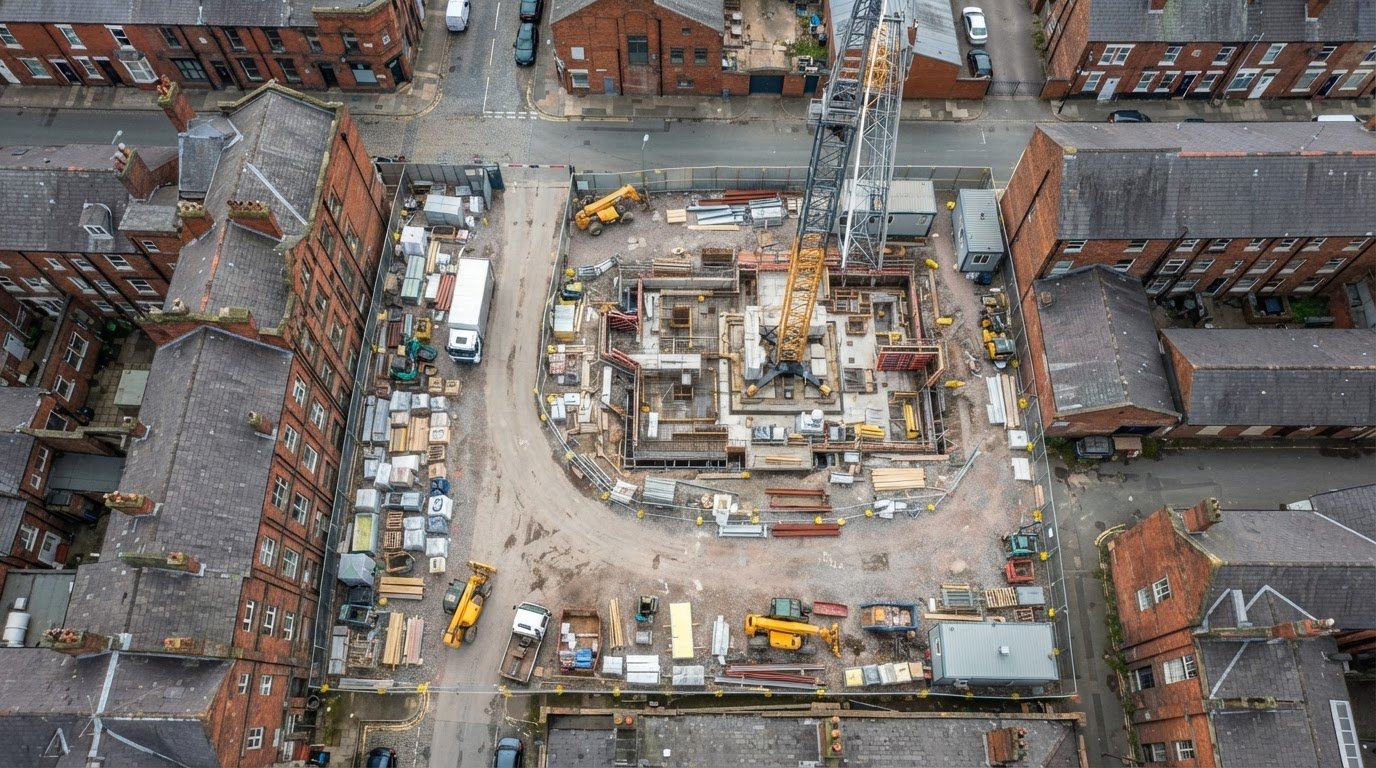
Drone imagery can help turn site logistics questions into measurable plans. Drone data for site logistics planning can show access routes, gates and laydown areas, while a measured model gives teams a basis for drawing crane exclusion zones at a 1:1 scale. The value lies not just in the aerial view, but in connecting that view to the site’s operational information.
When access, storage and crane activity must work together safely, a visual record alone may not be enough. This article explains what drone imagery can show, how aerial data can fit into GIS and BIM, and how ground conditions, obstacles and changing site layouts affect its usefulness. It also covers how current aerial information can support daily operations, from reviewing site constraints to understanding how space is used. You’ll learn what the data can contribute to planning and where it needs to be considered alongside other project information.
Key Takeaways
- Use aerial imagery to assess access routes, gate positions and physical constraints that can affect site movement.
- Measured imagery can help teams map laydown areas and plan crane exclusion zones alongside other site zones.
- Connecting current site data with GIS and BIM can give project teams a clearer basis for coordinating digital plans.
- Regular aerial monitoring can help reveal changes in site layout and support reviews of operational workflows.
Measuring access routes, gates and site constraints
Aerial imagery gives project teams a current view of routes, entrances and visible terrain across a construction site. Its value for logistics planning depends on combining that overview with suitable measurements and operational context.
Construction Logistics Baseline Mapping
Construction logistics baseline mapping records the site layout at a defined point, including visible boundaries, access routes, gates and terrain. It gives teams a shared reference for planning deliveries and tracking changes to the working area. For example, mapping a gate approach alongside a turning area can reveal potential conflicts between vehicle movements and stored materials. This baseline can support planning for just-in-time deliveries and prefabricated components, where arrival timing and unloading space need to align.
Drone and Ground Survey Comparisons
A drone survey captures broad aerial coverage, while a ground survey records details from positions on site. For logistics planning, imagery can help assess route continuity and visible obstructions; ground measurements can clarify features that need closer inspection. The right approach depends on the decision: mapping a site-wide route is different from confirming a specific surface or access detail.
How do drone surveys compare with ground surveys? Aerial surveys provide an overview of the site, while ground surveys can examine selected features directly. Using both can help teams relate broad route planning to conditions on the ground.
Accuracy depends on the capture method, image quality, positioning and visibility of features. Obstructions, changing site conditions and uneven terrain can affect interpretation. Imagery also cannot show hidden services beneath the surface. These limitations matter when a logistics decision depends on a precise boundary or a feature obscured by equipment.
Flight planning must account for obstacles, terrain, airspace restrictions, no-fly zones, payload limits, weather and the infrastructure needed for operations. NHS trial risk assessments include adverse weather and aircraft-system failures, with weather evaluations, maintenance protocols and dynamic risk appraisals as mitigations. These constraints affect when and how a capture can take place.
For just-in-time deliveries, the baseline needs to reflect changes to access and unloading conditions. If a prefabricated section is due at a restricted gate, for example, approach clearance and available space are important to sequencing. Updated models can help teams compare planned routes with visible site conditions and identify assumptions that may need review.
Can a professional drone survey measure laydown areas and crane exclusion zones from imagery?
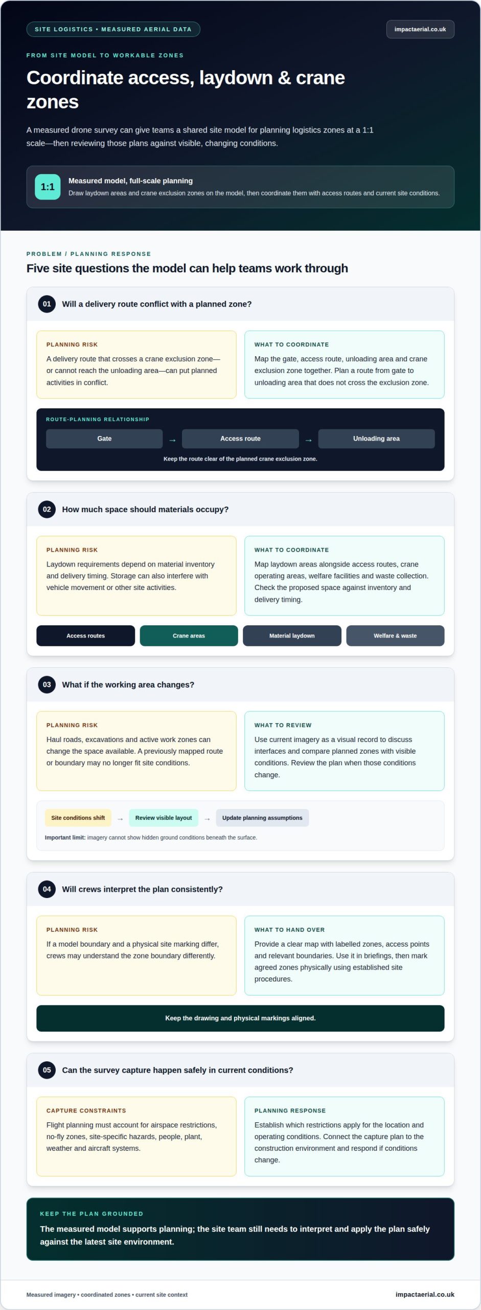
Yes. A professional survey can create a measured site model for drawing laydown areas and crane exclusion zones. Teams can map these zones at a 1:1 scale on the model, then coordinate their position with access routes and current site conditions. The model supports planning, but the site team still needs to interpret and apply the plan safely.
Zone sequencing helps prevent one activity from blocking another. A workable plan considers access, crane operating areas, material laydown, welfare facilities and waste collection. For example, a delivery route should connect the gate to an unloading area without crossing a planned crane exclusion zone. Material inventory and delivery timing also affect how much laydown space is needed.
Haul roads, excavations and active work zones can change the space available. A mapped haul road may need to remain clear as excavation edges or temporary work areas shift. Imagery gives teams a visual record for discussing these interfaces, but it cannot show hidden ground conditions. Plans should reflect the latest site environment and be updated when visible conditions change.
To hand the plan to site teams, provide a clear map with labelled zones, access points and relevant boundaries. Teams can use it in briefings, then mark agreed zones physically on site using their established procedures. The drawing and physical markings need to match; otherwise, crews may interpret a boundary differently from the model.
A UK construction-site flight must account for airspace restrictions, no-fly zones and site-specific hazards. Permissions depend on the location and operating conditions, so flight planning must establish which restrictions apply. Safety planning also considers people, plant, weather and aircraft systems, as well as how to respond if conditions change. This connects the capture plan to the construction environment.
For projects where site conditions are changing, aerial site imagery can provide a visual reference for reviewing logistics zones.
GIS, BIM and digital site management
GIS places site features in their geographic context, while BIM organises information around buildings and project assets. Aerial survey data can add a current spatial view to these systems. For example, a site team can compare a planned vehicle route with mapped boundaries, structures and temporary work areas. This shared context helps planners discuss how physical conditions relate to design information.
Drone scanning technology can produce warehouse maps with centimetre-level detail for workspace layout planning. On a construction site, mapped features can help teams review where access routes meet storage areas or structures. For drone data for site logistics planning, the coordinate reference and level of detail should suit the project’s GIS or BIM workflow. This alignment helps teams interpret locations consistently.
Digital plans also depend on current site information. A boundary surveyed two years earlier may no longer reflect changing conditions, such as a relocated entrance or expanded work zone. Comparing new aerial information with existing GIS layers or BIM models can reveal where updates may be needed. Teams can then distinguish site changes from design information before relying on a route or layout.
A useful handover connects the captured view to specific planning decisions:
- GIS layers can show boundaries, access points and site features in geographic context.
- BIM views can help relate those features to planned structures and project assets.
- Route layers can support reviews of planned vehicle circulation without implying live tracking.
For drone data for site logistics planning, teams should agree which source represents each feature. A GIS boundary may define the site edge, while the BIM model shows the proposed building footprint. If the layers conflict, recording the difference helps prevent teams from treating the visual overlay as a single verified design. The same approach supports updates as work areas move or new structures appear.
Drone imagery is a visual input, not a substitute for project coordination. Mapped information is more useful when it is labelled, dated and tied to a clear purpose, such as reviewing an access change or workspace layout. This makes the aerial record easier to interpret alongside GIS and BIM, giving planners a consistent basis for decisions.
Operations monitoring and workflow analysis
Aerial monitoring can help teams compare site activity with the planned work sequence. For example, repeated views may show whether deliveries, equipment movements and work areas are progressing as expected. This visual record gives operational reviews a shared reference instead of relying only on separate observations from different parts of the site.
Workflow analysis looks at how people, materials and plant move through the site. A survey can reveal recurring pinch points, such as vehicles queueing near an unloading area or materials obstructing a working route. Drone technology can help identify a supply-chain disruption within minutes, while manual searches can take hours. Images help locate visible issues, but site teams still need to interpret their cause.
Monitoring can also support discussions about safety compliance. Aerial views let teams review whether access routes remain clear and work areas match the current plan. For instance, a new storage zone might narrow a route used by delivery vehicles. Comparing imagery with the operational plan can highlight the change for review.
How often should construction sites be surveyed by drone? Survey frequency should follow the pace of operational change, not a fixed interval. A new capture is useful when a phase transition, access change or major shift in site activity could affect decisions. Stable areas may need less frequent review than active work zones.
For useful comparisons, each survey should record its capture date and purpose. Teams can then compare like with like, such as tracking changes to a haul route across successive work phases. A precise visual record supports discussion, but it does not replace site inspections or direct reports from workers.
Pairing aerial records with observations from site teams can clarify whether a visible change reflects a temporary delivery, a revised work sequence or a developing constraint. That distinction helps managers choose an appropriate response instead of treating every difference as a disruption.
Discuss site monitoring for your project when aerial records would support operational reviews.
Impact Aerial: Drone Commercial Property Surveys
Impact Aerial provides Drone Commercial Property Surveys for property and construction teams that need aerial information to support site decisions. For logistics planning, a survey can capture a clear view of site access, visible constraints and changing work areas. Construction Site Monitoring can also provide aerial records to help teams review progress and evolving site conditions.
These services are useful when existing site information needs a visual update or project teams need aerial evidence for planning discussions. Aerial Filming and Photography can provide additional visual material when a project requires it. Each capture should be shaped around the site context and the decisions the imagery is intended to support.
Contact Impact Aerial to discuss aerial survey needs for your site.
Make your next site decision with clearer evidence
Start by deciding which operational decision needs better site data. That focus helps shape a useful survey brief, whether the priority is reviewing a planned change, documenting conditions for project discussions or maintaining a visual record as work progresses. Drone data for site logistics planning is most valuable when the capture has a defined purpose and its outputs fit the way your team makes decisions.
Impact Aerial’s services also include Aerial Filming and Photography, PV Solar Farm Thermal Surveys and Drone Commercial Property Surveys. For a construction project, identify the site question that needs clearer visual evidence, then discuss how aerial capture can support it.
Plan a site drone survey with Impact Aerial and take the next planning decision forward with confidence.
Frequently Asked Questions
How does a professional drone survey support building a site logistics plan?
A professional survey gives planners visual evidence to consider alongside delivery schedules, construction phases and site requirements. For example, if a project plans to bring prefabricated sections through a particular entrance, the survey can help teams review the visible approach and nearby working space. The resulting information supports planning discussions; it does not determine whether a route is suitable without project-specific assessment.
How can drone data support construction site logistics planning?
Drone data can help teams assess how planned logistics interact with visible site conditions. A project manager might use aerial records to discuss a proposed storage change before it affects delivery access. A shared visual reference can also support communication between planners and site staff. The operational decision still depends on project requirements and information beyond the imagery.
What drone data and outputs are useful for site logistics plans?
Useful outputs depend on the planning question. Aerial photographs can help teams review visible site features, while 3D imaging and detailed topological graphics can support a more spatial view. For example, a logistics discussion about a temporary facility may benefit from imagery showing its relationship to nearby structures. Clear labels and an agreed purpose help teams interpret each output appropriately.
How can a provider integrate drone data with BIM, CAD and GIS site plans?
Integration starts by matching the survey information to the project’s intended use and existing plan references. The provider and project team need to establish which layers or model elements matter, such as site boundaries, building footprints or temporary works. They should also agree the required data format and coordinate reference before handover. This reduces ambiguity when teams compare aerial information with CAD, GIS or BIM records.
What is the provider workflow for using drone data to plan deliveries, traffic routes and storage areas?
A structured workflow links the site brief to capture, processing and handover. Impact Aerial’s published sequence is Consultation, Site Survey, Safety Assessment, Flight, Post-Production, Presentation, Handover & Sign-Off. For logistics planning, the brief can identify questions about delivery access, vehicle circulation or storage. The survey and presentation can then focus on information relevant to those decisions, rather than producing imagery without a defined purpose.
How can a drone survey provider monitor site access, progress and temporary facilities?
A provider can capture aerial records that help project teams review visible changes to access, construction progress and temporary facilities. For instance, teams can assess the placement of welfare cabins or temporary fencing against current site arrangements. Construction Site Monitoring is relevant when a project needs ongoing visual records. Site managers can use those records alongside their own operational information when reviewing changes.
 2 Norton Drive, Wythall, Birmingham, B47 6HH Company registration number: 11138586. VAT Number: 366 9068 55


