

What makes a drone survey valuable: the number of images captured, or the decisions those images help you make? A practical approach to managing a property portfolio with drone data starts with the decision. Roofs and façades can be difficult to assess consistently, and a collection of unlabelled images may not help you set maintenance priorities.
Drone evidence can make hard-to-access areas easier to review, but it is most useful when every capture has a clear purpose and is linked to an asset and a next step. This guide explains how aerial imagery, 3D imaging, detailed topological graphics and Thermal Image Surveys can support portfolio reviews, and how to turn the outputs into a repeatable process.
You’ll also find practical criteria for planning a professional drone survey, including safety, compliance and the final handover. Impact Aerial Ltd provides drone property surveys for property professionals in Birmingham and the West Midlands, following a defined workflow from Consultation through to Handover & Sign-Off. The aim is to provide an organised evidence base that supports a property review, not simply a larger image collection.
Key Takeaways
- Learn how managing a property portfolio with drone data means linking aerial evidence to identifiable assets and specific maintenance questions.
- Use consistent asset identifiers and file names so imagery is easier to retrieve, review and act on.
- Compare drone capture with conventional inspection approaches by considering access, visible evidence, disruption and the follow-up each property may need.
- Build a repeatable plan by defining the decision, selecting relevant assets and assigning responsibility for reviewing and recording actions.
- See how drone property surveys can provide roof and façade imagery, 3D imaging and detailed topological graphics for portfolio reviews.
What managing a property portfolio with drone data actually means
Managing a property portfolio with drone data means using aerial imagery and survey outputs to inform reviews of specific buildings and their components. Portfolio drone data is aerial evidence organised by asset and management question, so property teams can review visible conditions and decide what to do next. The goal isn’t to build the largest possible image library. It is to make relevant evidence useful for condition reviews, access planning, maintenance triage and documentation.
A folder of photographs alone is not a useful portfolio record. Each image or output needs context: which property it shows, which building element is visible, when it was captured and what question the review should address. For example, an overview of a roof can help a team identify areas for closer review, while a focused image can document a particular visible feature. The wider Unmanned aerial vehicle applications include commercial uses such as surveying, illustrating how aerial capture can contribute to structured property reviews.
For a visual overview of how drone outputs can support asset management, watch this video:
Which portfolio management questions can aerial evidence support?
Roof and façade imagery can support visual condition reviews by making hard-to-view areas available for examination from recorded perspectives. The evidence becomes more useful when each capture is tied to an asset, building element and management question. That context helps a reviewer distinguish a general roof overview from a closer view intended to document a particular visible feature.
- Which property and building element does the image show?
- What visible area or condition is the review focused on?
- Does the evidence help plan access or prioritise a follow-up review?
What drone data does not establish on its own
Imagery records what is visible from the captured viewpoint. On its own, it does not diagnose every underlying cause of a mark, defect or change, or establish the condition of concealed materials. Aerial evidence can inform a property review, but it is not a complete building survey or a replacement for every inspection method.
Use images to document observations and identify where further assessment may be appropriate, rather than treating them as a final technical diagnosis. If a finding calls for specialist investigation or a formal professional opinion, a qualified professional should interpret the evidence and advise on the next assessment. This distinction helps keep portfolio records informative without overstating what the capture can show.
Drone property surveys can provide high-resolution roof and façade condition imagery, 3D imaging and detailed topological graphics. Linked to clear asset references and a defined review question, these outputs give property teams an organised basis for deciding what to examine next and how to record that decision.
Turn drone captures into useful property records and decisions
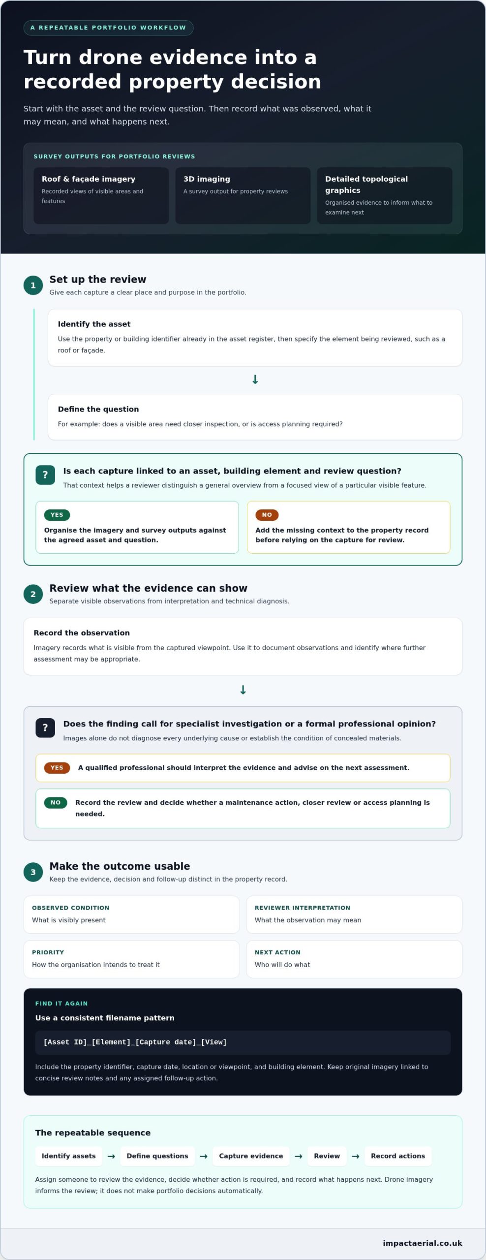
A repeatable recordkeeping process gives each capture a place in the portfolio and a route to follow-up. It also makes responsibilities clear: someone needs to review the evidence, decide whether action is required and record what happens next. A practical workflow is to identify assets, define questions, capture evidence, review it and record actions.
- Identify assets: Use the property or building identifier already in your asset register, then specify the relevant element, such as a roof or façade.
- Define questions: State what the review should help establish, such as whether a visible area needs closer inspection or whether access planning is required.
- Capture evidence: Organise imagery and survey outputs against the agreed asset and question.
- Review: Assign a person or role to examine the evidence and document observations separately from interpretation.
- Record actions: Note the decision, priority, responsible owner and follow-up status in the property record.
This sequence supports managing a property portfolio with drone data without assuming that software or imagery will make decisions automatically. It gives the team a consistent method for turning captured evidence into a recorded management response.
Build an asset-centred record
For each record, include the property identifier, capture date, location or viewpoint, and building element shown. Keep the original imagery linked to concise review notes and any assigned follow-up action. A filename pattern such as [Asset ID]_[Element]_[Capture date]_[View] helps staff find relevant evidence without relying on personal memory or informal folder names.
Apply the same identifiers and naming approach across the portfolio. That makes records for a particular building or element easier to retrieve and compare with earlier captures where available. Preserve what was observed as well as the reviewer’s interpretation, so another user can distinguish the evidence from the conclusion drawn from it.
Translate observations into maintenance follow-up
Keep four fields distinct: observed condition, what is visibly present; reviewer interpretation, what it may mean; priority, how the organisation intends to treat it; and next action, who will do what. For example, a reviewer can record a visible area of concern and recommend further assessment without presenting the image itself as a diagnosis.
Separate decisions requiring prompt operational attention from routine monitoring and recordkeeping. Assign an owner and status to each follow-up, and avoid technical condition ratings unless the organisation is using a stated assessment method. This keeps priorities transparent while leaving specialist judgement to qualified professionals when further investigation is needed.
Impact Aerial’s drone property surveys provide aerial evidence for property reviews, following a workflow from Consultation through to Handover & Sign-Off. To see how the service can support your records, explore Impact Aerial’s drone property survey service.
Compare drone data with conventional property inspection approaches
Drone capture and conventional inspection methods can answer overlapping but different questions. The right approach depends on the building, access conditions, purpose of the inspection and level of detail required. Aerial imagery can show roofs and façades, while physical access or specialist investigation may be needed to assess details that a camera cannot reveal.
Use this comparison to choose an approach for each asset, rather than treating one method as a universal replacement for another:
- Access: Drone capture can provide views of elevated areas that are difficult to inspect from ground level. Conventional methods can provide close physical access when hands-on examination is needed.
- Visible evidence: Aerial imagery records visible roof and façade conditions from selected viewpoints. A closer inspection may be appropriate when the question concerns a detail that imagery cannot show clearly.
- Disruption: In suitable situations, drone work can reduce the need for scaffolding when gathering visual evidence. It does not remove the need for scaffolding or other access arrangements in every case.
- Documentation: Captured imagery and survey outputs can support remote review and property records. Other inspection methods may produce observations or findings for a different assessment purpose.
- Follow-up: Use aerial evidence to identify questions for review or access planning. If the issue requires close examination or diagnosis, plan an appropriate further assessment.
Aerial evidence can improve visibility and documentation where suitable, but it complements conventional inspections rather than replacing every form of assessment.
When aerial capture can add practical value
Elevated views can help document roof areas, façades and other hard-to-view building elements without arranging physical access solely to obtain a visual record. The resulting evidence can be reviewed remotely and retained alongside an asset record. Depending on the survey objective, outputs may also include 3D imaging or detailed topological graphics.
For example, a portfolio manager reviewing several buildings could use captured views to identify which locations warrant closer attention, then plan follow-up access around those findings. The imagery supports that decision; it does not determine the technical cause or condition by itself.
When another assessment may still be needed
Visible imagery cannot establish the state of concealed materials or diagnose every underlying defect. If the management question requires close physical examination, testing or specialist interpretation, another assessment may be needed. The decision should reflect the building, available access and purpose of the review, not a blanket preference for aerial or ground-based methods.
In practice, managing a property portfolio with drone data means using aerial evidence where it adds useful visibility, then selecting follow-up methods according to what the evidence can and cannot establish. This helps teams avoid treating an image as a complete professional assessment.
Create a repeatable drone-data plan for your property portfolio
Begin a portfolio plan with a decision, not a blanket request to capture every building. Define the question first, then select the assets whose evidence could help answer it. For example, a concern about roof condition may make certain buildings relevant, while other assets can wait for a separate management question.
Before capture, agree what the team needs to review: overview imagery, closer views of specific building elements, or survey outputs suited to the assessment purpose. Set out who will review the material, who can interpret findings and who will coordinate follow-up. This makes ownership clear before the evidence arrives.
Consider access arrangements, site conditions and the purpose of the assessment when planning capture. A consistent plan does not mean capturing every property on a fixed cycle. It means making each survey serve a defined management need. For broader preparation, use a complete guide to drone survey data collection alongside a UK drone compliance guide, so the capture brief and operational planning are considered together.
Scope the first capture around decisions
Start with known maintenance questions and access challenges, then select the assets that relate directly to them. For each property, state the evidence required and the decision it should inform. This helps distinguish useful coverage from imagery that adds volume without helping the review.
- Set the scope: Identify the relevant properties and building elements, such as roofs or façades.
- Define the review: Specify what the property team needs to see and how the evidence will support its decision.
- Assign responsibility: Name who will review and interpret the findings, and who will coordinate any further assessment or maintenance follow-up.
Keep the brief practical. If the question concerns one hard-to-view area, focus the capture on that element rather than expanding the scope without a management reason.
Set up consistent review and handover
Before work begins, agree how deliverables will be labelled and organised against portfolio asset identifiers. Confirm who will receive and store the material, who owns the review, and how observations and actions will be recorded. A planned review meeting or defined review process helps the team move from viewing evidence to documenting a decision.
Repeat capture is most useful when it serves a clear purpose, such as reviewing a known area again or maintaining a comparable record for a specific asset. Define what will be compared and how the result will inform action. Without that purpose, repeat imagery may add records without adding useful information.
A clear brief aligns the survey scope, evidence and intended decisions from the outset. To discuss a property survey brief with Impact Aerial, outline the portfolio question and relevant assets.
How Impact Aerial supports property portfolio drone data projects
For property teams, a drone survey is most useful when its evidence supports a defined review. Impact Aerial provides Drone Property Surveys and Drone Service for Data Collection, with work that can include roof and façade imagery, 3D imaging and detailed topological graphics. These outputs help teams examine relevant building areas and support portfolio decisions. They are evidence for review, not a substitute for every professional assessment.
Start with the management question to set a useful project scope. Whether the aim is to document hard-to-view building elements, inform access planning or create a record for property review, the required evidence can be considered as part of the project workflow. This connects the capture to the asset and its intended use.
A defined service workflow from consultation to handover
Each project follows a defined sequence from initial discussion through to final delivery:
- Consultation
- Site Survey
- Safety Assessment
- Flight
- Post-Production
- Presentation
- Handover & Sign-Off
This sequence shows how work progresses from discussing the brief and surveying the site through to capture, preparation and presentation of the outputs. At handover, final assets are provided via a shared Google Private Cloud Drive or WeTransfer Pro. The receiving team can then organise the material with its property records and use it in the relevant review process.
Credentials and outputs for property professionals
Operational competence and appropriate insurance matter when planning commercial aerial work. All operators are CAA-GVC Certified as of early 2026, and Impact Aerial holds full UK CAA Operational Authorisation. The company also carries £5 million commercial liability insurance. These credentials give property teams clear information about the operational and risk-management aspects of a survey project.
Impact Aerial uses the DJI Matrice 210 Enterprise platform, with drones equipped for 4K HDR video. Survey outputs are shaped around the project and may include high-resolution roof and façade condition imagery, 3D imaging or detailed topological graphics. The defined workflow and relevant outputs can support a property team’s evidence-gathering plan, while the team retains responsibility for maintenance decisions and any further professional assessment.
For teams managing a property portfolio with drone data, a clear brief connects the buildings under review to the evidence required and the decisions it needs to inform. Request a free, no-obligation quote to discuss your property survey project.
Make your next portfolio review more evidence-led
Choose one property decision where better aerial evidence could make a practical difference. Start with a focused brief, identify the buildings and elements that matter, then decide how the information will feed into your existing review and maintenance processes. A focused first project can help your team establish which outputs are useful before applying the approach more widely.
That gives managing a property portfolio with drone data a clear direction: each capture should support an identifiable management question, and each review should lead to a considered decision. Refine the brief as your team learns which outputs help it plan access, assess visible conditions or determine where further professional input is needed.
Impact Aerial supports property professionals with drone survey projects shaped around their requirements. If you’re ready to define a brief for your assets, plan your property survey with Impact Aerial.
With a clear purpose and a reliable process for using the evidence, your portfolio team can make its next review more informed and actionable.
Frequently Asked Questions
Can drone data help manage multiple properties?
Yes. Drone data can give property teams consistent visual evidence across multiple assets when each capture is connected to the right building record. A portfolio team could group survey outputs by site and building element, then use them to identify where further review may be useful. Managing a property portfolio with drone data is most practical when the team defines what it needs to compare and who will use the evidence.
What information can a drone property survey provide?
A drone property survey can provide aerial imagery and survey outputs selected for the project. Depending on the brief, these may include roof and façade condition imagery, 3D imaging, detailed topological graphics or Thermal Image Surveys. The useful output depends on the review purpose: a property team documenting an elevated façade may need different evidence from one seeking a broader visual record. Survey imagery records visible information; it does not establish every underlying cause.
Can drone imagery replace a building survey?
No. Drone imagery should not be treated as a complete building survey. It can provide useful visual evidence of areas visible to the camera, especially elevated roofs and façades, but it does not cover every building element or assessment requirement. Before commissioning a capture, define the question it should support. If the decision requires a broader condition assessment, close physical examination or specialist interpretation, include that professional input in the assessment plan.
Can drone data identify defects inside a building?
No. Exterior drone imagery cannot directly inspect internal building spaces or concealed elements. It records what is visible from the captured viewpoints, so it may document an external feature that prompts a further question, but it cannot establish an internal defect or its cause. If a concern relates to the interior, arrange an appropriate internal inspection or specialist investigation. Use aerial evidence as supporting context, not as proof of conditions it cannot show.
How should property teams organise drone survey images?
Store images within the relevant property record and make the asset identifier easy to recognise in folders and filenames. Add context such as the building element, capture date and viewpoint, so a colleague can find the right material without relying on who collected it. Keep original files linked to review notes and decisions, and apply the same naming convention across sites to make retrieval and later comparisons more straightforward.
Is drone data useful for documenting roof and façade condition?
Yes. Aerial imagery can document visible roof and façade areas from elevated viewpoints that may be difficult to examine from ground level. This gives property teams material for remote review or to retain alongside an asset record. Its usefulness depends on the viewpoint captured and the question being assessed. If the review needs close physical examination or must establish a concealed cause, plan suitable follow-up rather than relying on imagery alone.
How does Impact Aerial deliver property survey work?
Impact Aerial takes property survey projects through Consultation, Site Survey, Safety Assessment, Flight, Post-Production, Presentation and Handover & Sign-Off. Final assets are provided through a shared Google Private Cloud Drive or WeTransfer Pro. The project brief determines which survey outputs are prepared for the intended property review, and the handover provides a clear point for adding them to property records and arranging review.
 2 Norton Drive, Wythall, Birmingham, B47 6HH Company registration number: 11138586. VAT Number: 366 9068 55


