

In 2026, the difference between a hobbyist with a camera and a certified technical consultant isn’t just about the hardware; it’s about the legal and financial security of your entire operation. You likely know that aerial data, such as PV solar farm thermal surveys UK, can radically improve your asset management, yet the fear of CAA non-compliance or receiving low-grade data often stalls the decision to hire. It’s difficult to distinguish between a casual flyer and a specialist who understands the nuances of professional standards and risk mitigation.
This guide ensures you can leverage professional drone technology for cinematic 4K HDR media and precise technical data collection while maintaining total regulatory compliance. We’ll show you how to secure accurate, actionable results through a hassle-free, fully insured flight operation. We’ll break down the latest 2026 UK class markings, the necessity of CAA GVC certification, and the specific DJI Enterprise hardware required to deliver the industry-leading quality your business demands.
Key Takeaways
- Understand the mandatory legal requirements for 2026, including why CAA GVC certification is the baseline for any professional commercial drone operation in the UK.
- Learn how to use high-resolution PV solar farm thermal surveys UK to identify anomalies and optimize energy output through accurate, actionable data collection.
- Discover the operational workflow for construction site monitoring and property surveys that prioritizes site safety and comprehensive risk assessments.
- Evaluate the benefits of integrating 4K HDR aerial filming with post-production services to create high-impact visual content for the property and advertising sectors.
- Identify the essential insurance benchmarks, such as £5m commercial liability, required to protect your business from legal risks during complex aerial projects.
The Evolution of Professional Drone Services in the UK
Professional drone services have transitioned from being viewed as high-tech novelties to becoming critical infrastructure tools for UK businesses. Today, an Unmanned aerial vehicle is no longer just a flying camera; it’s a sophisticated data collection platform. These integrated solutions provide a bridge between cinematic media and technical datasets, offering insights that were previously cost-prohibitive or physically impossible to obtain. As we enter 2026, the industry is defined by a “Safer, Faster, Cheaper, Greener” framework. By replacing traditional methods with aerial technology, companies significantly reduce their carbon footprint and operational overheads while improving safety standards across the board.
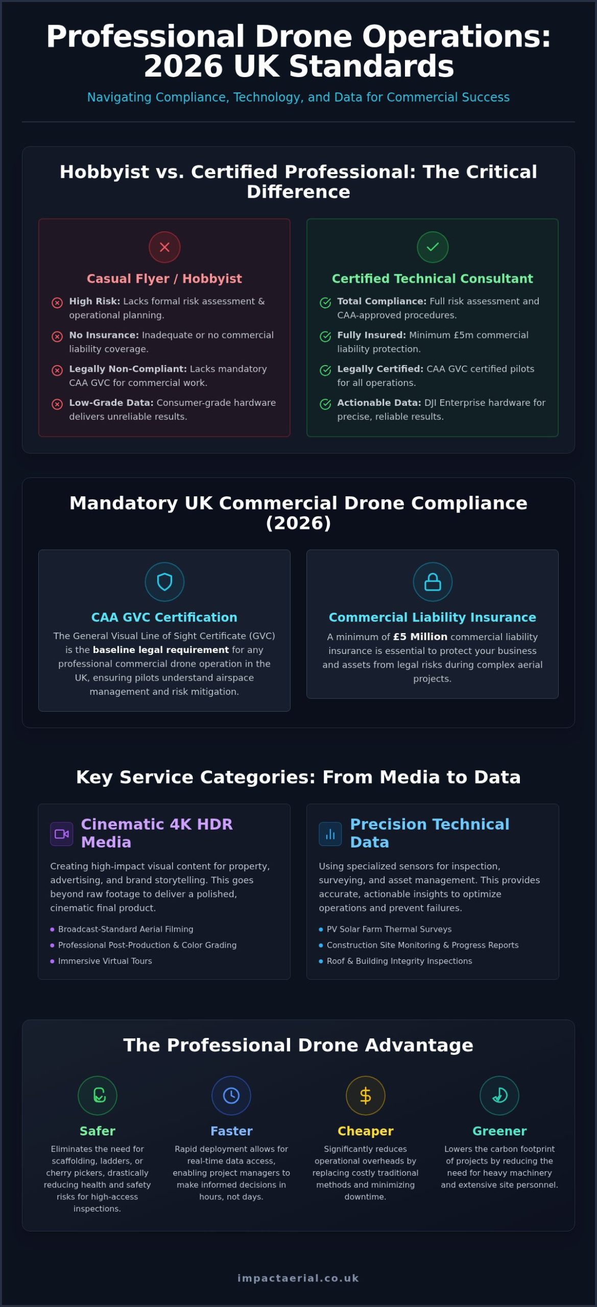
Under the 2026 regulatory landscape, the Civil Aviation Authority (CAA) has tightened the standards for commercial operators. Simply owning a drone is not enough for complex industrial work. Professional services now require GVC (General Visual Line of Sight Certificate) certified pilots who understand the nuances of risk assessment and airspace management. This ensures that every flight is not only productive but fully compliant and insured, providing the reassurance that your business is protected from legal liability.
The Business Case for Aerial Integration
The most immediate benefit of drone adoption is the mitigation of health and safety risks. By utilizing drones for roof inspections or tall structure assessments, you eliminate the need for scaffolding, cherry pickers, or ladders. This doesn’t just save money; it protects your workforce. Rapid deployment allows for real-time data access, meaning project managers can make informed decisions in hours rather than days. We provide unique perspectives that ground-based teams simply cannot replicate, ensuring every angle of a site is documented with 4K HDR precision.
Commercial Applications Across UK Industries
UK industries are increasingly reliant on these specialized services to maintain a competitive edge. In property and real estate, high-impact visuals are standard for marketing, while construction firms use drones for site monitoring and structural integrity checks. The renewable energy sector has seen a significant shift toward data-driven maintenance. Specialized PV solar farm thermal surveys UK are now a requirement for efficient asset management. These surveys use high-resolution thermal sensors to detect cell defects or “hot spots” that are invisible to the naked eye. By identifying these issues early, operators can prevent failures and maximize energy yield across the grid. This technical approach transforms a simple flight into a vital maintenance strategy.
From Cinematic Media to Technical Data: Key Service Categories
Professional drone operations in 2026 are categorized by their output: either high-fidelity creative content or precision technical data. While hobbyists might focus on a single shot, a professional operator integrates hardware like DJI Enterprise drones to deliver multi-layered results. This includes everything from immersive virtual tours for commercial galleries to specialized industrial inspections. The shift toward data-centric services means that aerial platforms are now essential for maintaining large-scale infrastructure and high-value property assets.
Professional Aerial Videography and Post-Production
High-quality marketing requires more than raw footage. Using an aerial filming drone with 4K HDR sensors ensures every frame meets broadcast standards. The true value lies in the post-production phase. Professional editing turns raw clips into a cinematic brand story through expert color grading and pacing. This is essential for property developers and agencies who need to showcase the scale and quality of their projects with total clarity.
Precision Drone Surveying and Data Collection
Data-centric applications have revolutionized building maintenance and infrastructure management. A professional drone survey allows for comprehensive roof and building inspections without the safety risks or costs associated with high-access equipment like scaffolding or cherry pickers. For the renewable energy sector, this technology is indispensable. Implementing PV solar farm thermal surveys UK allows operators to identify defective cells or bypass diode failures that compromise energy output.
According to guidelines on PV system maintenance, early detection of thermal anomalies is critical for maximizing the lifecycle and ROI of solar assets. These specialized PV solar farm thermal surveys UK use radiometric sensors to provide precise temperature data across thousands of panels in a single flight. This technical consultancy approach ensures that maintenance teams can target specific repairs rather than conducting manual, time-consuming inspections across the entire site. If you’re looking to protect your infrastructure investments, it’s wise to consult with a technical drone specialist to discuss your specific data requirements.
Beyond technical data, immersive virtual tours offer an interactive experience by combining aerial perspectives with ground-based content. This holistic approach is particularly effective for large-scale commercial real estate and tourist attractions. It allows potential clients or visitors to explore a site remotely with a level of detail that traditional photography cannot match. By integrating these diverse service categories, businesses can secure both the marketing assets and the technical data they need to thrive in a competitive market.
Understanding Compliance: Why CAA GVC Certification and Insurance Matter
Compliance is the non-negotiable foundation of any professional drone operation. By 2026, the UK Civil Aviation Authority (CAA) drone regulations have evolved to include mandatory Remote ID broadcasting for most commercial-grade aircraft. Any pilot conducting work for “valuable consideration” must hold a valid drone license. This ensures the operator has passed the necessary competency tests and is registered with the CAA. For technical applications like PV solar farm thermal surveys UK, operating without these credentials isn’t just a safety risk; it’s a significant legal liability for the client. Professional operators act as technical consultants, managing the complex paperwork and site-specific risk assessments so you don’t have to.
GVC vs. A2 CofC: What Clients Need to Know
It’s vital to distinguish between the A2 Certificate of Competency (A2 CofC) and the General Visual Line of Sight Certificate (GVC). While the A2 CofC is suitable for lightweight drones in open spaces, the GVC is the gold standard for industrial work. It requires a pilot to maintain a detailed Operations Manual and secure a PDRA01 Operational Authorisation from the CAA, which currently carries an annual fee of £524. This certification allows for much greater flexibility, especially for projects in congested areas or when using heavy DJI Enterprise hardware. Verifying these credentials before the first flight protects your project from being grounded by local authorities or failing a safety audit.
Insurance and Liability in Professional Operations
Risk mitigation extends beyond pilot skill to include robust financial protection. Hobbyist insurance policies are insufficient for commercial risks. Professional operators carry specialist liability cover that meets the requirements of EC 785/2004. While some freelancers carry minimal cover, £5m commercial liability insurance is the standard for reputable UK firms serving the construction and energy sectors. This level of insurance is essential when performing PV solar farm thermal surveys UK, where drones fly in close proximity to high-value assets. It covers third-party injury and property damage, ensuring that your business is fully insulated from financial loss. This meticulous approach to safety and regulation is what separates a professional service from a casual operator.
Planning Your Project: The Workflow of a Professional Drone Operation
A successful drone mission is built on a foundation of methodical planning and technical precision. It isn’t merely about launching an aircraft; it’s a structured workflow designed to deliver specific business outcomes. The process begins with an initial consultation where we define your project goals, required deliverables, and any site-specific constraints. For example, executing PV solar farm thermal surveys UK requires a different flight profile compared to a cinematic marketing shoot. We establish the technical parameters early to ensure the data collected is both accurate and actionable for your maintenance teams.
The Importance of Pre-Flight Risk Assessment
Meticulous pre-flight planning is the hallmark of a professional operator and a core requirement for CAA compliance. Before arriving on-site, we conduct a comprehensive site survey and risk assessment to identify potential hazards like overhead power lines, tall structures, or public access points. We also manage the complex task of checking airspace restrictions via NOTAMs (Notices to Air Missions). If your site is within a Flight Restriction Zone (FRZ) near an airport, we secure the necessary permissions from Air Traffic Control well in advance. Weather monitoring is equally critical; we track wind speeds and precipitation levels to ensure the operation can proceed safely without compromising the quality of the 4K HDR visuals or radiometric data.
On-site execution is handled by GVC certified pilots using specialized DJI Enterprise hardware. This equipment is designed for industrial reliability, allowing us to capture high-resolution imagery and precise thermal data even in challenging environments. This phase is characterized by a “safety-first” approach, where the pilot-in-command maintains constant situational awareness to protect your assets and personnel throughout the flight duration.
Post-Production and Deliverable Formats
The final phase involves transforming raw captures into professional-grade assets that drive value for your business. For marketing-focused drone photography, post-production is where we apply color correction and retouching to ensure the visuals align with your brand identity. Technical projects, such as PV solar farm thermal surveys UK, require specialized software analysis to produce orthomosaic maps or detailed thermal reports that highlight specific panel anomalies. Delivery timelines typically range from 24 to 72 hours depending on the complexity of the data processing required. If you’re ready to start your project with a compliant and expert team, you can book your professional drone consultation today to discuss your specific requirements.
Why Partner with Impact Aerial for Your UK Drone Requirements
Impact Aerial stands at the intersection of creative excellence and technical precision. We provide a comprehensive suite of professional services that bridge the gap between high-end cinematography and industrial data collection. As a technical consultant, we don’t just fly; we manage the entire lifecycle of your project. This includes everything from the initial brief to the final delivery of broadcast-quality media or actionable technical reports. Our commitment to the highest safety standards is evidenced by our CAA GVC certification and £5m commercial liability insurance, providing the reassurance you need when operating near high-value assets.
West Midlands Roots, Nationwide Reach
Based in Birmingham, we leverage our regional knowledge of the West Midlands while maintaining the logistical capability for nationwide deployment. Providing consistent drone services across the UK requires a meticulous approach to travel planning, local airspace permissions, and risk management. We’ve successfully delivered projects for the property, construction, and advertising sectors nationwide. This reach ensures that multi-site organizations receive a uniform standard of data and media quality across their entire portfolio, regardless of the specific location.
Our Technology and Post-Production Edge
We utilize the latest DJI Enterprise hardware to ensure superior flight stability and image resolution. This equipment is specifically designed for the rigors of industrial work, making it the ideal platform for PV solar farm thermal surveys UK. However, the Impact Aerial difference lies in our post-production capabilities. While many operators simply hand over raw files, we provide full post-production editing as part of our service. This turns raw 4K HDR footage into compelling brand stories and transforms complex radiometric data into clear, prioritized maintenance schedules.
Our client-centric approach focuses on reliability and precision. When conducting PV solar farm thermal surveys UK, we understand that your ROI depends on the accuracy of our findings. By combining high-end sensors with expert data analysis, we identify defects that others might miss. This meticulous attention to detail ensures your project is completed on time and to the highest professional standards. We act as your trusted specialist, allowing you to focus on your core business while we handle the complexities of the aerial environment.
Securing Your Competitive Edge with Professional Aerial Solutions
Choosing a drone partner in 2026 is a strategic decision that impacts both operational safety and the quality of your business data. We’ve explored how the transition to professional standards requires more than just high-end hardware; it demands a meticulous approach to CAA GVC certification and comprehensive risk management. Whether you’re looking to enhance your marketing with 4K HDR media or require technical PV solar farm thermal surveys UK to protect your infrastructure, the focus must always remain on precision and legal compliance.
Impact Aerial provides the reassurance of CAA GVC Certified Pilots and £5m commercial liability insurance, ensuring your project is handled by technical consultants rather than just operators. Our expert post-production services turn raw data into actionable insights and cinematic stories that drive results. You can Request a Professional Drone Service Quote from Impact Aerial today to discuss your specific site requirements. We look forward to helping you leverage the full potential of professional drone technology for your next project.
Frequently Asked Questions
Do I need a special license to hire a drone service in the UK?
You don’t need a personal license to hire a service, but the operator you contract must hold a valid UK Civil Aviation Authority (CAA) commercial authorization. For most professional work in 2026, this means hiring a pilot with a General Visual Line of Sight Certificate (GVC). This certification ensures the pilot is trained in complex risk assessments and maintains a formal Operations Manual, protecting your business from legal liability during aerial projects.
What is the difference between a professional drone pilot and a hobbyist?
The primary differences lie in regulatory compliance, insurance, and technical hardware. Professional pilots hold GVC certification and carry commercial-grade liability insurance, whereas hobbyists typically lack these legal protections. Professionals use DJI Enterprise drones capable of capturing specialized data, such as PV solar farm thermal surveys UK. They act as technical consultants who understand airspace management and post-production, rather than individuals simply capturing casual imagery without a structured safety framework.
How much does it cost to hire professional drone services?
Costs for professional drone services vary based on the project’s complexity, location, and the specific hardware required. Factors such as the need for specialized thermal sensors or extensive post-production editing will influence the final quote. While we don’t provide fixed price lists, a professional service includes the cost of CAA compliance, £5m liability insurance, and expert data analysis. It’s best to request a tailored consultation to define your specific deliverables and site constraints.
Can drones fly in rain or high winds?
Most professional drones shouldn’t fly in heavy rain or winds exceeding 20 to 25mph, though some Enterprise models have higher weather resistance ratings. Safety is the priority; high winds can destabilize the gimbal, affecting the quality of 4K HDR visuals or technical data. We monitor weather patterns closely in the days leading up to a shoot. If conditions are unsafe, we reschedule the flight to ensure the integrity of your data and the safety of the aircraft.
Are there restrictions on where drones can fly in UK cities?
Yes, there are significant restrictions on flying drones in UK cities, particularly within Flight Restriction Zones (FRZs) near airports. Professional operators must secure specific permissions from Air Traffic Control and the CAA when flying in congested areas. We handle all airspace authorizations and local council notifications as part of our project management. This meticulous planning ensures that your urban construction monitoring or property filming stays fully compliant with the latest 2026 aviation laws.
How long does a typical drone survey or filming session take?
A typical session ranges from a few hours for a property survey to several days for large-scale industrial sites. The duration depends on the total area and the density of data required. Conducting PV solar farm thermal surveys UK involves methodical flight paths to capture every panel with radiometric precision. We provide a detailed timeline during the initial consultation so you know exactly how long the on-site execution and subsequent data processing will take.
What insurance coverage should a professional drone company have?
A professional drone company must have specialist commercial liability insurance that complies with EC 785/2004 regulations. Standard hobbyist or public liability policies often exclude aviation risks, leaving you vulnerable. We carry £5m in commercial liability insurance as an industry standard for high-value sectors like construction and energy. This coverage protects your business against third-party injury or property damage, providing essential reassurance and financial security throughout the duration of the flight operation.
What deliverables will I receive after a drone survey?
Deliverables are tailored to your project goals and can include raw 4K HDR footage, edited cinematic videos, or high-resolution orthomosaic maps. For technical inspections like PV solar farm thermal surveys UK, you’ll receive detailed reports and annotated imagery highlighting specific anomalies. We also provide full post-production services, ensuring your marketing content is polished and your technical data is actionable. All files are typically delivered via a secure digital link within 24 to 72 hours after the flight.
 2 Norton Drive, Wythall, Birmingham, B47 6HH Company registration number: 11138586. VAT Number: 366 9068 55


