
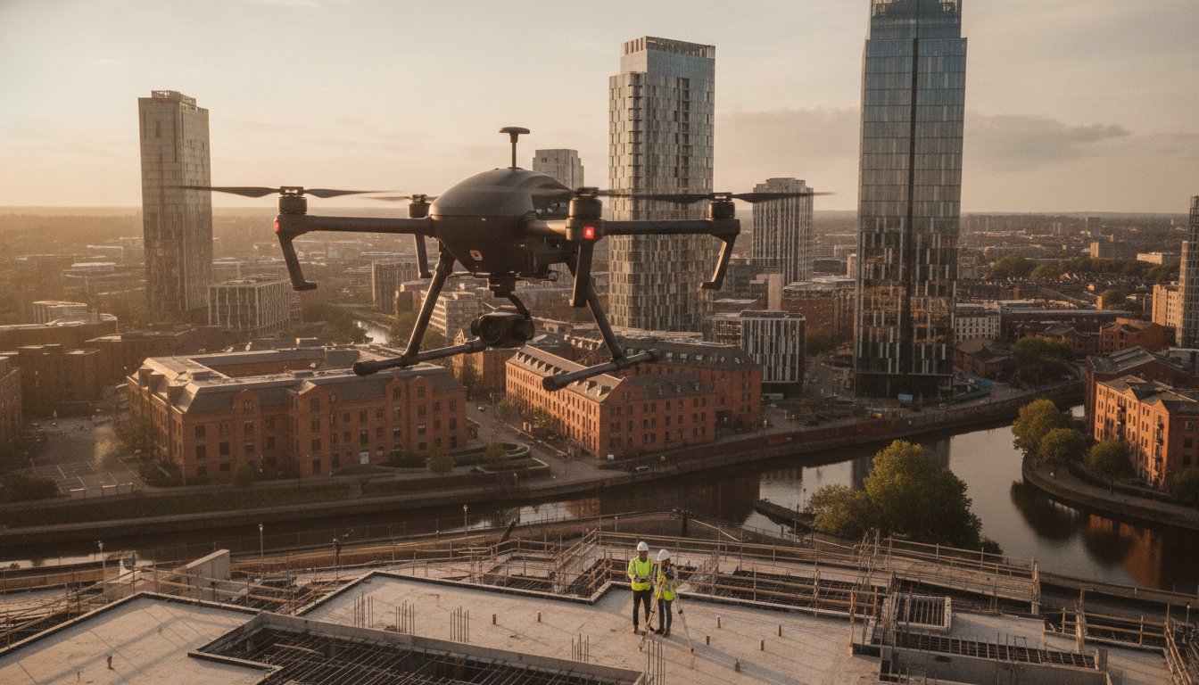
In the complex, high-stakes airspace of the West Midlands, the difference between a breathtaking 4K marketing reel and a significant legal liability often rests on a single certification. As the city’s skyline evolves, the demand for aerial drone services Birmingham has shifted from simple photography to a requirement for meticulous risk mitigation. You’ve likely seen the potential for aerial views to revolutionise your project, yet the fear of uninsured mishaps or inaccurate survey data often stalls progress.
We understand that managing urban flight restrictions and the latest 2026 CAA regulations feels like a minefield. This guide demonstrates how expert drone integration can transform your operations by delivering high-precision surveying and cinematic photography that’s as safe as it is visually stunning. You’ll learn exactly how to leverage CAA GVC-certified expertise and £5m liability insurance to secure high-resolution 4K HDR content. We’ll also break down the technical requirements for site monitoring and solar farm inspections, ensuring your next project is backed by actionable data and total regulatory compliance.
Key Takeaways
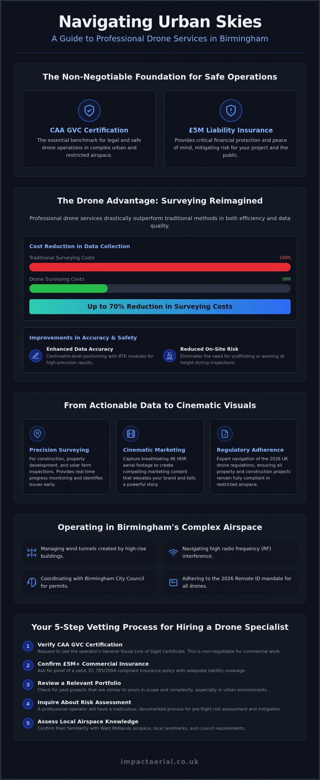
- Identify why CAA GVC certification and £5m commercial liability insurance are the essential benchmarks for safe drone operations in urban Birmingham.
- Discover how professional aerial drone services Birmingham can reduce traditional surveying costs by up to 70% while improving data accuracy.
- Learn how to elevate your brand storytelling by converting raw 4K HDR aerial footage into cinematic marketing content through expert post-production.
- Navigate the updated 2026 UK drone regulations to ensure your property and construction projects remain fully compliant in restricted airspace.
- Follow a proven 5-step vetting process to select a technical specialist who bridges the gap between creative filming and rigorous aeronautical safety.
The Landscape of Aerial Drone Services in Birmingham (2026)
Professional drone operations in 2026 are defined by the ability to operate safely within high-density urban environments. While hobbyist flights focus on basic imagery, professional aerial drone services Birmingham rely on CAA GVC certification and industrial-grade hardware to deliver results. This distinction is vital as the city undergoes massive transformation under the Big City Plan. From the historic streets of the Jewellery Quarter to the sprawling construction sites near the new Curzon Street station, drones provide a level of oversight that traditional methods cannot match.
Local expertise in the West Midlands is essential for project success. Planning a flight over the Bullring or the commercial districts of Solihull requires an intimate knowledge of local micro-climates and terrain. Our teams understand how the wind tunnels created by Birmingham’s newest high-rises affect flight stability. This regional focus ensures every mission is planned with the highest safety margins, protecting both the public and your project’s timeline.
To better understand the scale of the city’s modern architecture from a unique perspective, watch this footage:
The Shift from Visuals to Actionable Data
The industry has moved beyond “nice-to-have” photography. Clients now demand 4K HDR resolution for the clarity it provides in technical drone surveys and inspections. Whether you’re identifying a hairline fracture in a commercial roof or monitoring a multi-million-pound regeneration project, the quality of the output dictates the value of the insights. Today’s professional drone service is a sophisticated hybrid of aviation and IT, where the flight is merely the method of data acquisition. This evolution supports a vast range of commercial drone applications, ensuring every frame captured serves a specific business purpose.
Why Birmingham is a Unique Hub for UAV Operations
Birmingham is a primary engine for the UK’s drone economy. The concentration of engineering talent and large-scale infrastructure projects makes it a testing ground for advanced aerial solutions. Operating in the City Centre, Edgbaston, or Solihull presents specific challenges, from managing radio frequency interference to coordinating with Birmingham City Council for permits. Since January 1, 2026, all UK1, UK2, and UK3 class drones must have their Remote ID functions active, a requirement our fleet strictly follows. Successful flight planning around landmarks like the Library of Birmingham requires a meticulous approach to risk assessment that only a specialist provider can offer. This level of precision is exactly what distinguishes professional drone services from casual operators.
Precision Drone Surveying: Transforming West Midlands Property and Construction
Traditional surveying often involves high costs and significant logistical hurdles. By switching to drone surveys, West Midlands firms can reduce traditional data collection costs by up to 70%. This efficiency doesn’t sacrifice quality. Instead, it enhances it. Using professional aerial drone services Birmingham allows site managers to monitor construction progress in real-time, providing a perspective that identifies bottlenecks before they delay a project.
Safety is a non-negotiable priority in urban construction. Drones eliminate the need for scaffolding or cherry pickers during initial inspections, drastically reducing health and safety risks. We utilise DJI Enterprise drones because they offer technical advantages that consumer models lack:
- Centimetre-level positioning accuracy via RTK (Real-Time Kinematic) modules.
- Advanced obstacle avoidance sensors for navigating tight urban sites.
- Interchangeable payloads, including high-resolution thermal and zoom cameras.
All operations are conducted in strict accordance with UK drone regulations, ensuring that data collection is both legal and safe. This meticulous approach provides the reassurance that your site data is accurate and your liability is managed. When you hire aerial drone services Birmingham for roof inspections, you receive a comprehensive digital record that traditional methods simply can’t match.
Specialised PV Solar Farm Thermal Surveys
Solar assets in the West Midlands require consistent monitoring to maintain peak output. Our thermal surveys use high-sensitivity sensors to detect cell defects and hotspot anomalies that are invisible to the naked eye. Regular aerial inspections provide a significant ROI by preventing small issues from becoming costly system failures. We process this raw thermal data into actionable maintenance reports, allowing your engineers to target specific panels with surgical precision. You can learn more about our data-led approach to see how these tools integrate with your current maintenance workflow.
Commercial Property and Roof Inspections
Managing large estates in Birmingham involves constant structural vigilance. Drones are now the primary tool for identifying RAAC (Reinforced Autoclaved Aerated Concrete) and other building material defects in hard-to-reach areas. We capture high-detail imagery that serves as robust evidence for insurance claims and structural assessments. Beyond simple photos, we create digital twins and 3D models that allow property managers to virtually walk through their assets. This level of detail is essential for long-term asset management and identifying preventative maintenance needs before they escalate into emergency repairs.
Creative Aerial Filming: High-End Visuals for Birmingham Brands
Birmingham’s competitive market requires more than just standard video. High-end brands are using aerial filming drone technology to capture perspectives that were previously only possible with expensive helicopter charters. By integrating professional aerial drone services Birmingham into their marketing strategy, businesses can create cinematic narratives that resonate on both social media and broadcast platforms. This isn’t just about height; it’s about movement and the ability to weave a story through the city’s architectural landscape.
First-Person View (FPV) drones are transforming how we experience Birmingham venues. These agile aircraft can navigate through tight indoor spaces, providing a continuous, high-speed tour that feels visceral and immersive. When these shots are combined with ground-based filming, the result is a cohesive narrative that guides the viewer from the exterior skyline into the heart of the brand’s physical location. Every creative mission follows UK Civil Aviation Authority regulations, ensuring that even the most complex shots are executed with absolute safety and compliance.
Virtual Tours and Immersive Experiences
Interactive 360-degree aerial panoramas have become the benchmark for Birmingham’s luxury real estate and corporate sectors. Our workflow for virtual tour creation involves capturing high-resolution imagery that is stitched into a seamless, interactive environment. This allows prospective buyers or stakeholders to explore a property from every angle before a site visit. In 2026, these immersive experiences are no longer optional for high-value listings; they are the standard for engagement in professional aerial drone services Birmingham packages.
Post-Production: Turning Raw Footage into Content
Capturing the footage is only the first stage of the process. Raw data is transformed into polished content through our dedicated post-production suite. Professional colour grading ensures that every frame matches the brand’s visual identity, while meticulous sound design adds depth to the cinematic experience. We manage the entire lifecycle from the initial storyboard to the final edit, delivering content optimised for 4K HDR displays and mobile platforms. This end-to-end service ensures that the technical precision of the flight translates directly into a high-tier marketing asset.
Urban Flight Safety: Navigating Birmingham Airspace and Regulations
Operating in a major city like Birmingham requires a deep understanding of aviation law and local bylaws. For any commercial project, holding a valid UK drone license is the absolute minimum requirement. However, for complex urban missions, the CAA GVC (General Visual Line of Sight Certificate) is the gold standard. This certification proves that a pilot has the advanced training necessary to manage risks in high-density environments. When commissioning aerial drone services Birmingham, verifying these credentials is your first line of defence against project liability.
Risk management in a city centre isn’t a formality; it’s a meticulous process. A professional Birmingham flight risk assessment involves mapping every potential obstacle, from the BT Tower to the overhead lines of the West Midlands Metro. We establish clear flight corridors and identify emergency landing zones long before the drone leaves the ground. This level of preparation is backed by our £5m commercial liability insurance, providing the financial reassurance that corporate clients require for large-scale urban projects.
Birmingham City Council and Airspace Restrictions
Navigating the specific bylaws of Birmingham City Council is essential for legal compliance. Flying over city parks like Cannon Hill or busy thoroughfares requires specific permissions and a clear understanding of local restrictions. Coordination with Birmingham Airport (BHX) is also a critical step for projects within its Flight Restriction Zone. Within the context of Birmingham City Centre, the “Congested Area” rule strictly prohibits flying drones within 150 metres of any residential, commercial, industrial, or recreational area unless the operator holds specific CAA authorisations. You can contact our compliance team to discuss the specific permits required for your next city-based project.
Data Protection and Privacy (GDPR) in Aerial Photography
Professional aerial drone services Birmingham must balance high-quality visuals with strict adherence to GDPR. Capturing footage in a busy metropolitan area inevitably involves recording members of the public. We use advanced data storage protocols and person-redaction techniques to protect individual privacy. While the operator handles the technical side of data security, clients also share a responsibility to ensure the final content is used ethically. We provide clear guidance on these responsibilities during the planning phase, ensuring your project is compliant from capture to delivery.
Hiring Professional Drone Services: A Checklist for Success
Hiring a specialist for aerial drone services Birmingham is a critical decision that impacts both the visual quality of your project and your legal standing. Vetting a drone services provider requires looking beyond a flashy website. You’re hiring an aviation partner, not just a photographer. While it’s tempting to compare quotes based on price alone, the cheapest drone hire can be the most expensive mistake. If an operator lacks the proper GVC certification or the necessary £5m liability insurance, a single incident on a Birmingham construction site could result in catastrophic financial and legal consequences for your business.
A professional engagement follows a structured 5-step process to ensure consistent results:
- Consultation: Defining the technical requirements and creative goals of the project.
- Planning: Conducting detailed risk assessments and securing Birmingham City Council permits.
- Flight: Executing the mission using industrial-grade hardware and certified pilots.
- Data Processing: Converting raw files into 4K HDR assets or survey-grade maps.
- Delivery: Providing the final assets via secure digital transfer or integrated reporting platforms.
Evaluating the Portfolio and Technical Specs
A professional showreel should demonstrate more than just pretty pictures. Look for stability in the footage, precise camera movements, and variety in high-density urban environments. It’s also vital to understand the hardware being used. There’s a significant gap between consumer-grade drones and the DJI Enterprise hardware we employ. Enterprise models offer redundant battery systems and RTK accuracy, which are essential for high-precision data collection and safety in professional aerial drone services Birmingham. Always ask if the drone used is suited for the specific task; a cinematic FPV drone for an indoor tour is a very different tool from a thermal-equipped drone for a solar farm survey.
Booking and Project Management Workflow
Weather in the West Midlands is notoriously unpredictable. A reliable operator always monitors the forecast and builds “Plan B” dates into the schedule to ensure project timelines aren’t derailed by rain or high winds. You should also account for lead times when booking. While some flights can be authorised quickly, complex missions in restricted Birmingham airspace or those requiring specific council permits can take several weeks to finalise. The final stage of the workflow is post-production. We ensure that our editing suite aligns the final output with your brand’s specific goals, whether that’s a cinematic marketing reel or a technical structural report. This end-to-end management is what separates a professional service from a casual hire.
Future-Proofing Your Birmingham Projects with Aerial Intelligence
The integration of advanced UAV technology is no longer a luxury for West Midlands businesses; it’s a strategic necessity. From the high-precision data required for solar farm thermal inspections to the cinematic storytelling used by leading brands, the scope of aerial drone services Birmingham continues to expand. You’ve seen how professional operators bridge the gap between raw data and actionable business insights while maintaining strict compliance with evolving aviation laws. Safety is the foundation of every successful flight.
Success in the city’s complex airspace depends on meticulous planning and technical expertise. By prioritising CAA GVC certified pilots and robust £5m commercial liability insurance, you protect your assets and ensure the highest standards of operational safety. As Birmingham’s skyline continues its rapid transformation, having a trusted technical partner is essential for capturing the data and visuals that drive growth.
Ready to elevate your next project with industry-leading precision and creative excellence? Request a professional drone service quote from Impact Aerial today and partner with Birmingham and West Midlands specialists who understand the unique demands of urban flight. We’re ready to help you reach new heights.
Frequently Asked Questions
Do I need a permit to fly a drone in Birmingham city centre?
Yes, commercial drone operations in Birmingham city centre require specific authorisations. You must comply with CAA regulations and typically need to liaise with Birmingham City Council for land use permissions. Professional aerial drone services Birmingham handle this by conducting pre-flight risk assessments and securing necessary flight clearances from local authorities and Birmingham Airport (BHX) when operating within its Flight Restriction Zone. This ensures your project remains fully legal and avoids liability issues.
What is the difference between a standard drone pilot and a CAA GVC certified one?
A CAA GVC (General Visual Line of Sight Certificate) is the professional standard for complex urban flight. While a standard flyer might hold a basic Flyer ID or A2 CofC, a GVC-certified pilot has undergone rigorous training specifically for operating in congested areas. This certification is essential for many commercial projects in Birmingham. It allows for greater operational flexibility while maintaining the highest safety protocols required by national aviation authorities for urban environments.
How much does professional drone hire cost in Birmingham for 2026?
Professional drone service costs vary based on the technical complexity and the specific outputs required for your project. Factors such as the need for thermal sensors, high-precision RTK data, or cinematic post-production will influence the final quote. Rather than looking for the lowest price, businesses should evaluate the value of CAA compliance and insurance. We provide bespoke quotes that reflect the specific hardware and expertise needed for high-resolution 4K HDR marketing or technical survey data.
Can drones fly in the rain or high winds common in the West Midlands?
While DJI Enterprise drones feature advanced IP ratings for moisture resistance, we always prioritise flight safety. High winds or heavy rain common in the West Midlands can affect both data accuracy and aircraft stability. We monitor local weather forecasts meticulously and typically schedule “Plan B” dates to ensure your aerial drone services Birmingham are conducted during optimal conditions. This approach guarantees the highest quality visuals and protects the integrity of the collected data.
How long does a typical drone roof survey take to complete?
A typical drone roof survey for a commercial property in Birmingham usually takes between one and four hours on-site. This duration depends on the building’s footprint and the level of detail required for structural assessments or insurance claims. Because drones eliminate the need for scaffolding or cherry pickers, the process is significantly faster than traditional methods. This allows for rapid data collection without disrupting your daily business operations or site activities.
What insurance coverage should a professional drone company have?
A professional drone operator must carry specialist commercial third-party liability insurance. We maintain £5m of commercial liability coverage, which is the standard requirement for most corporate and construction projects in the UK. This insurance provides essential protection against unforeseen incidents, offering you psychological comfort and financial security. It’s vital to never hire an operator who only carries hobbyist insurance, as this won’t cover commercial activities and leaves your business exposed.
Can drones be used for indoor filming in Birmingham venues?
Yes, drones are highly effective for indoor filming in Birmingham venues, particularly when using specialised FPV (First-Person View) aircraft. These smaller, agile drones are designed with prop guards to operate safely within tight interior spaces, creating immersive “fly-through” tours. This technology is perfect for showcasing event spaces, manufacturing facilities, or retail environments. It provides a continuous and engaging perspective that traditional ground-based cameras simply cannot replicate for your brand storytelling.
How quickly can I receive the final edited footage or survey data?
Turnaround times depend on the complexity of the project and the required level of post-production. Raw imagery or basic survey data can often be delivered within 24 to 48 hours. However, cinematic marketing videos or detailed thermal survey reports that require professional colour grading and data analysis typically take five to ten working days. We manage the entire workflow from capture to final edit, ensuring the output meets your specific brand standards and technical requirements.
 2 Norton Drive, Wythall, Birmingham, B47 6HH Company registration number: 11138586. VAT Number: 366 9068 55


