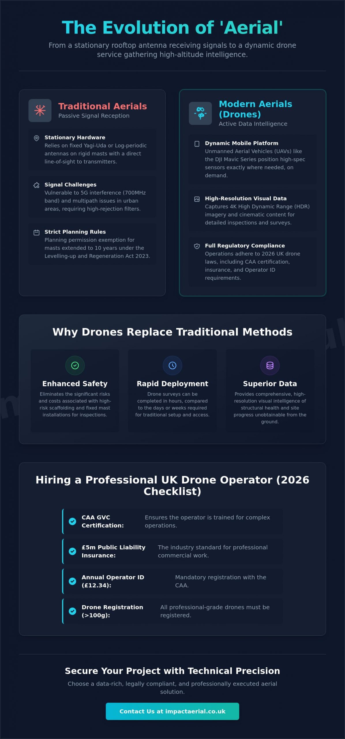
The traditional TV aerial is no longer the primary gateway to modern media or data; instead, a new era of high-altitude intelligence has taken its place. In 2026, the distinction between a rooftop antenna and a professional drone service involves more than just hardware. It’s about managing a complex world of UK regulations, from the 100g weight threshold for registration to the strict 10-year planning rules for masts and antennas.
We understand that this niche but increasingly diverse market can be difficult to understand, especially when safety and professional standards are your top priority. This guide promises to help you distinguish between basic consumer tools and professional drone services, covering everything from the £12.34 annual Operator ID fee to the impact of the Media Act 2024. We provide a structured overview of modern aerial solutions to ensure your project is data-rich, legally compliant, and executed with the technical precision that provides true peace of mind.
Key Takeaways
- Understand how the term ‘aerial’ has transitioned from a stationary rooftop antenna to a dynamic category of mobile data-gathering and professional drone services.
- Learn to mitigate modern signal challenges, such as 5G interference, by choosing the appropriate high-gain hardware for your specific geographic area.
- Evaluate the significant cost and safety benefits of replacing traditional scaffolding or fixed masts with rapid-deployment drone surveys for building inspections.
- Recognise the critical importance of CAA GVC certification and the industry-standard £5m liability insurance when vetting a professional operator in the UK.
- Gain the technical insights required to secure high-resolution imagery and breath-taking cinematic content while ensuring full compliance with 2026 UK drone laws.
Defining ‘Aerial’: From TV Antennas to Drone Technology
The term aerial has undergone a profound transformation in the UK market. For decades, it referred exclusively to passive reception hardware installed on domestic and commercial rooftops. In 2026, the definition has expanded. It now encompasses a sophisticated service category where data is actively harvested from the sky rather than just received. This shift from a stationary noun to a mobile service represents a leap in how we interact with technology and the built environment.
For property owners and commercial developers, understanding this distinction is vital. A passive system focuses on signal strength for broadcasting, whereas an active platform provides high-definition visual intelligence. Choosing the right solution depends on whether your goal is media consumption or high-level data gathering. This choice impacts everything from your compliance with the Levelling-up and Regeneration Act 2023 to the overall safety of your site operations. We provide the technical expertise to help you make an informed decision for your project.
To better understand the technical components involved in traditional signal hardware, watch this helpful video:
Traditional Aerials: Signal Reception
Most UK homes still rely on Yagi-Uda or Log-periodic antennas for digital terrestrial television. These devices operate by focusing radio waves onto a central element to deliver clear broadcast signals. To maintain performance, these systems require rigid masts and brackets to ensure a direct line-of-sight to the nearest transmitter. However, in dense urban environments like Birmingham or London, signal multipath interference and physical obstructions often limit the effectiveness of these static installations. Under the Levelling-up and Regeneration Act 2023, property owners must also be aware that the planning permission exemption period for these masts has increased from four to ten years. Proper installation of F-connectors and high-quality coaxial cabling remains essential to prevent signal loss in these challenging settings.
Modern Aerial Platforms: UAVs and Drones
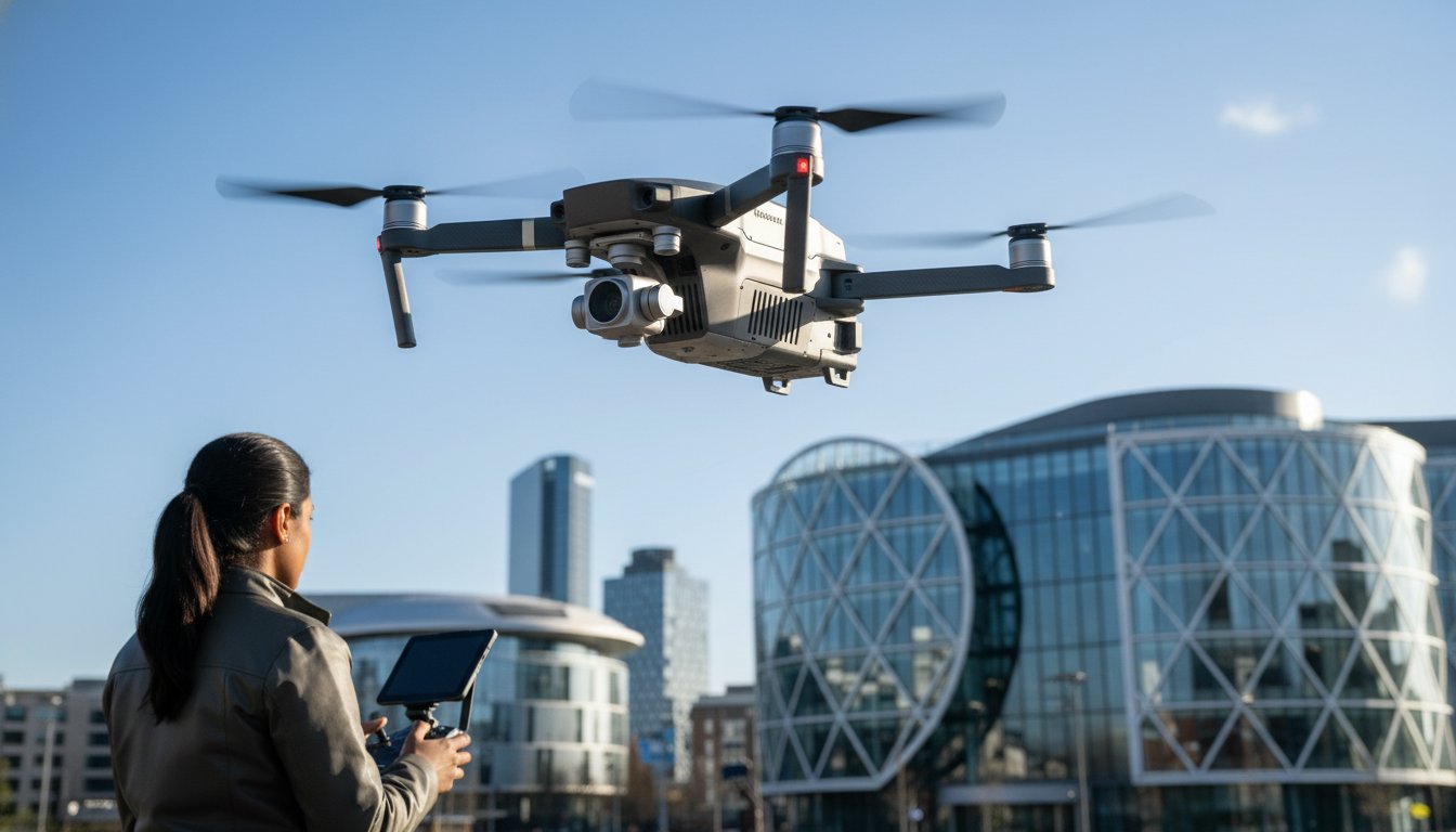
The most significant evolution in this sector is the rise of the Unmanned Aerial Vehicle (UAV). Unlike a fixed antenna, a UAV is a mobile platform capable of positioning high-specification sensors exactly where they are needed. Drones have effectively replaced the need for static masts in many commercial applications, such as topographical surveys and roof inspections. Our fleet utilizes the latest 4K High Dynamic Range (HDR) DJI Enterprise drones, including the Mavic 4 Pro and DJI Air 3S, to capture perspectives that were previously impossible to reach. This technology has revolutionised property management, allowing for detailed inspections without the cost and risk of scaffolding. By moving the data collection point from the roof to the sky, we provide a more comprehensive view of structural health and site progress with total technical precision.
Traditional Aerial Systems: TV, Radio, and Communication Masts
Traditional hardware remains the backbone of UK communications infrastructure, even as we transition toward mobile platforms. In 2026, the primary challenge for any fixed aerial installation is the proliferation of 5G signals. The 700MHz frequency band, now heavily used for mobile data, frequently bleeds into the frequencies used by digital terrestrial television. This requires the integration of high-rejection filters to maintain picture stability. For commercial property developers, a standard installation no longer suffices. High-gain antennas are essential in fringe reception areas to pull in a usable signal, whereas omni-directional models are reserved for high-signal urban zones where multi-path interference is less of a concern.
Commercial Integrated Reception Systems (IRS) have become the gold standard for apartment blocks and office complexes. These systems combine signals from a single high-quality array and distribute them to hundreds of points. This eliminates the “forest of antennas” on rooftops, which is a significant aesthetic and maintenance advantage. Regular maintenance of these roof-mounted masts is non-negotiable. British weather, particularly high winds and salt air in coastal regions, causes mechanical fatigue in brackets and oxidisation in coaxial cabling. If you’re managing a large-scale project, our professional services ensure these systems are installed and maintained to the highest industry standards.
Optimising Signal Strength in the UK
Correct alignment with local transmitters like Sutton Coldfield or Crystal Palace is the first step in a professional installation. We use spectrum analysers to ensure the signal-to-noise ratio remains within the 25dB to 35dB range for optimal digital performance. Amplifiers should be used sparingly. Over-amplifying a poor signal only increases noise, leading to pixelation or total signal loss. Weatherproofing is equally critical. We utilise self-amalgamating tape and UV-stable cabling to prevent water ingress, which is the leading cause of system failure in the UK.
Specialised Communication Aerials
The modern rooftop now hosts more than just TV hardware. Specialised DAB and FM arrays are required for professional-grade radio reception in commercial studios. Additionally, the rise of smart buildings has introduced LoRaWAN and IoT (Internet of Things) aerial solutions. These low-power, wide-area network antennas allow building managers to collect data from thousands of sensors simultaneously. While our current focus remains on terrestrial infrastructure, our broader expertise in data-gathering is informed by international standards, including FAA commercial drone regulations, ensuring a holistic approach to technology. Integrated arrays that combine satellite, terrestrial, and data-gathering hardware are now the preferred choice for forward-thinking developers.
The Evolution of Aerial Platforms: Why Drones are Replacing Masts
While traditional masts serve a vital purpose for signal reception, the modern aerial platform is no longer bolted to a chimney stack. For developers and property managers, the shift toward mobile data capture represents a significant cost-benefit victory. Fixed masts require permanent installation, planning considerations, and long-term maintenance. In contrast, a rapid-deployment drone survey provides a dynamic solution that can be launched in minutes. This transition isn’t just about convenience; it’s a strategic move that reduces the financial burden of site inspections by as much as 60% in many commercial cases.
Safety remains our primary driver for replacing static masts with drone technology. Traditional inspections often involve working at height on ladders or expensive scaffolding, which introduces significant risk to personnel. By using a professional drone service, you keep your team’s feet firmly on the ground while the aircraft handles the high-altitude work. Furthermore, the data density provided by a drone is incomparable. A fixed mast or rooftop camera offers a single, static perspective. A drone-captured aerial view provides ten times the detail, allowing us to zoom into specific structural defects or survey large-scale sites with millimetre precision.
Comparing Fixed and Mobile Aerial Solutions
The time savings associated with mobile platforms are substantial. Installing a commercial-grade mast can take several hours and requires physical access to the roof. A drone flight can be completed in under twenty minutes, overcoming physical obstacles like tall trees or neighbouring buildings that would otherwise block a fixed sensor. Drone-based aerial inspections deliver a superior return on investment by cutting operational costs by up to 70% compared to traditional scaffolding or cherry picker hire.
The Role of DJI Enterprise Technology
Our fleet relies on DJI Enterprise technology to deliver the high-quality results our clients expect. These aircraft are equipped with 4K HDR cameras and thermal sensors, changing the way we approach data-gathering for heat loss surveys and structural analysis. The precision of photogrammetry allows us to create detailed 3D models of construction sites, providing a level of monitoring that fixed masts simply cannot match. While we operate under strict UK CAA guidelines, the global shift toward these platforms is mirrored in the Federal Aviation Administration (FAA) drone regulations, which highlight the increasing reliance on UAS for critical infrastructure. Using professional-grade equipment isn’t just about the image; it’s a requirement for maintaining the commercial liability insurance that provides our clients with total peace of mind.
Commercial Aerial Services: Data Collection, Filming, and Surveys
Commercial aerial services have matured into a cornerstone of industrial efficiency. As of May 2026, the UK drone market is projected to grow at a compound annual rate of 10.18%, reaching a valuation of USD 2.7 billion by 2034. This growth is driven by the demand for high-precision data that informs multi-million pound decisions. For construction site monitoring, we provide a bird’s-eye view that tracks progress against architectural plans. This level of oversight ensures safety protocols are followed and helps developers avoid costly delays through real-time site intelligence.
Thermal surveys represent another high-ROI application. For PV Solar Farm operators, identifying a single failing cell via heat-signature detection can prevent systemic inefficiencies. We use radiometric thermal sensors to pinpoint these issues from the air. This allows for targeted maintenance that keeps energy production at its peak without the need for manual ground-based testing across hundreds of acres. It’s a faster, safer, and more accurate way to protect renewable energy investments.
Aerial Photography and Videography
Cinematic content is essential for modern property marketing. We capture unique perspectives for commercial developers that showcase the scale and context of a project in ways ground-level photography cannot. Delivering professional assets requires more than just a flight; our post-production process ensures every 4K HDR frame is colour-graded and optimised for high-impact advertising. You can learn more about aerial filming drone capabilities to see how we produce these breath-taking end results.
Technical Aerial Surveys and Inspections
Safety and speed are the primary benefits of our technical inspection services. A traditional roof survey often requires days of preparation and significant expense for scaffolding. We complete the same task in a few hours using high-resolution imagery to identify structural issues like water ingress or masonry cracks. This data-gathering is also the foundation for creating digital twins and 3D virtual tours, which are increasingly used in building management. Our what is a survey drone guide provides a deep dive into the technical specifications required for these precision tasks.
If you’re ready to integrate these advanced technologies into your next project, our professional aerial services provide the technical precision and peace of mind your business requires.
Hiring a Professional Aerial Specialist in the UK
Hiring a professional aerial specialist involves strict adherence to UK Civil Aviation Authority (CAA) standards. Since January 1, 2026, the regulatory landscape has tightened significantly. Any drone weighing 100g or more now requires registration, and all new hardware must carry a UK class mark (UK0 to UK6). For commercial projects, a hobbyist flyer is a liability. We hold the CAA GVC Certification, which is the legal prerequisite for complex commercial operations in the UK. This qualification demonstrates that we possess the technical knowledge and flight competence to operate safely in a niche but increasingly diverse market.
For added peace of mind, we carry £5m in commercial liability insurance. This is the industry standard for working on construction sites, infrastructure projects, and commercial properties. When vetting a pilot, you should always verify their credentials via the Drone Safe Register or ARPAS-UK. These affiliations confirm the operator is vetted, insured, and current with 2026 legislation. Choosing a specialist based in Birmingham and the West Midlands offers distinct advantages for local projects. We understand the specific airspace restrictions and geographic challenges of the region, ensuring smoother logistics and faster deployment for your site.
Compliance and Safety Standards
The transition from the old PfCO (Permission for Commercial Operation) to the current GVC (General Visual Line of Sight Certificate) was a major shift in UK law. It ensures that every pilot understands the latest safety protocols, including the mandatory use of green flashing lights for night flying and Remote ID broadcasting for UK-classed drones. Before any aircraft takes off, we conduct exhaustive risk assessments and flight planning to mitigate potential hazards. For more details, see our UK drone license compliance guide.
Requesting an Aerial Quote
Securing an accurate price for aerial services depends on a clear project scope. A cinematic filming session for a property developer requires different equipment and planning than a high-precision technical survey using photogrammetry. When preparing your brief, specify the location, the desired data resolution, and any specific site hazards. This allows us to provide a methodical, structured quote that reflects the technical requirements of your project. We recommend Contacting Impact Aerial for a professional consultation to discuss how our technical precision can benefit your specific project.
Securing the Future of Your High-Altitude Projects
The evolution of technology has redefined the concept of an aerial platform. We’ve moved beyond simple signal reception to a landscape where high-specification data collection is the industry standard. Whether you’re managing a commercial property development or conducting a technical roof inspection, the key to success lies in choosing a partner that prioritises both precision and legal compliance. It’s no longer just about seeing the site; it’s about gathering actionable intelligence that protects your investment and informs your long-term strategy.
Our team provides the expertise needed to navigate the complexities of 2026 UK aviation rules. With a fleet of 4K HDR DJI Enterprise drones and CAA GVC Certified pilots, we ensure your project is executed with the highest technical standards. For added peace of mind, we back every operation with £5m commercial liability insurance. This combination of advanced hardware and rigorous safety protocols allows us to deliver results that are both legally compliant and technically superior. We’re ready to help you capture the data required to move your project forward with total confidence.
Book Your Professional UK Drone Service Today
Frequently Asked Questions
Do I need a license to use an aerial drone for my business in the UK?
Yes, you must have a valid Operator ID and the pilot must hold a CAA GVC (General Visual Line of Sight) Certificate for commercial work. As of January 1, 2026, any drone weighing 100g or more with a camera requires registration with the Civil Aviation Authority. We maintain all necessary certifications to ensure your project remains fully compliant with UK aviation law.
What is the difference between a TV aerial and a drone survey?
A TV aerial is a stationary device designed to receive broadcast signals from a transmitter for media consumption. In contrast, a drone survey is an active data-gathering service that uses mobile sensors to capture high-definition imagery and structural data. While the former is a piece of hardware, the latter is a professional aerial service providing technical intelligence.
How much does a professional aerial filming shoot cost in 2026?
Professional filming rates in the UK typically range from £250 to £600 for a half-day session. For a full day of cinematic production, prices generally fall between £500 and £1,100 based on industry data from May 2026. These rates cover the pilot’s expertise, high-specification DJI Enterprise equipment, and the necessary safety planning for your specific site.
Can a drone aerial survey detect roof leaks or thermal loss?
Yes, drone surveys equipped with radiometric thermal sensors can accurately identify heat signatures and moisture ingress. This technology allows us to detect insulation gaps or flat roof leaks that are invisible to the naked eye. By pinpointing these defects early, property owners can implement targeted repairs and significantly improve the energy efficiency of their buildings.
What are the CAA regulations for flying drones in congested urban areas like Birmingham?
Operating in congested areas like Birmingham requires strict adherence to CAA rules which prohibit flying over crowds of people. Our pilots maintain direct visual line of sight at all times and follow the latest UK class marking requirements (UK1 to UK6) introduced in early 2026. We conduct thorough risk assessments before every flight to ensure the safety of the public and nearby infrastructure.
How high can a commercial aerial drone fly for photography?
The legal height limit for a commercial drone in the UK is 120 metres, which is approximately 400 feet, above the ground. This altitude is sufficient for capturing wide-angle property views and detailed topographical data. Flying above this limit requires specific permission from the CAA to ensure the safety of manned aircraft in the vicinity.
Do I need insurance to hire an aerial photographer?
Yes, you should only hire an operator who holds EC785/2004 compliant commercial liability insurance. We maintain £5m in coverage to provide our clients with total peace of mind during complex site operations. This insurance protects your business against unforeseen risks and is a key indicator of a professional, vetted specialist.
How long does it take to get the results from an aerial survey?
Raw imagery is often available within 24 hours of the flight. More complex data sets, such as processed photogrammetry models or detailed roof inspection reports, typically take between 48 and 72 hours to complete. This timeline ensures our technical team has sufficient time to perform the meticulous post-production required for high-quality professional assets.
