

By 2026, the standard for project oversight has shifted from occasional site walks to a continuous, digital audit trail. Relying on manual reporting isn’t just inefficient; it’s a significant risk to your project’s timeline and personnel safety. Professional construction site drone monitoring UK now provides the verifiable data needed to settle stakeholder disputes before they escalate. It’s frustrating when traditional surveys come back with high costs and low-resolution data that doesn’t integrate with your BIM workflows.
You already know that maintaining a safe, compliant site is your top priority. This guide will show you how to leverage commercial-grade drone technology to create a transparent record of progress while keeping your team out of harm’s way. We’ll examine the latest 2026 CAA GVC regulations, the transition to Remote ID requirements, and how high-quality 4K HDR assets can provide the precision your investors demand. From initial risk assessments to post-production data delivery, you’ll discover how to build a more reliable, data-driven construction environment.
Key Takeaways
- Learn how automated UAV data collection is replacing manual site walks to create a more accurate and systematic digital record of your project.
- Understand the technical advantages of high-resolution orthomosaics and 3D point clouds for seamless integration into your existing BIM workflows.
- Discover how construction site drone monitoring UK enhances site safety by eliminating the need for personnel to navigate hazardous or uneven terrain.
- Navigate the 2026 regulatory landscape, including the critical importance of CAA GVC certification and £5m commercial liability insurance for site compliance.
- Explore how using professional-grade DJI Enterprise hardware ensures high-precision 4K data for reliable project milestone tracking and stakeholder reporting.
What is Construction Site Drone Monitoring?
Construction site drone monitoring UK represents a fundamental shift in how project managers oversee active builds. At its core, this process involves the systematic use of Unmanned Aerial Vehicles (UAVs) to capture dated, georeferenced data across a project’s entire footprint. While traditional site walks rely on manual observation and subjective reporting, drone-based systems automate data collection to ensure every measurement is accurate and repeatable. Understanding the full scope of drone applications in construction is essential for firms looking to modernize their workflows in 2026.
By scheduling weekly or fortnightly flights, contractors can create a chronological digital twin of the build. This record provides an indisputable evidence trail that tracks progress against the master schedule. Construction monitoring is the intersection of surveying and visual documentation.
To better understand this concept, watch this helpful video:
Visual Progress vs. Technical Data
Modern UK projects demand a hybrid approach that satisfies both marketing and engineering requirements. Visual monitoring utilizes high-resolution photography and 4K HDR video to provide stakeholders with clear, easy-to-digest updates. In contrast, technical monitoring focuses on photogrammetry, 3D point clouds, and orthomosaic mapping. These data-rich assets allow for precise site measurements and seamless integration with existing project management software. Combining these methods ensures that while investors see the visual progress, the site team has the raw data needed for technical audits.
The Role of the Professional Drone Operator
Professional operators do more than just fly drones; they manage the scientific consistency of the site’s data. This involves meticulously planning automated flight paths to ensure that data captured on different dates is perfectly aligned for chronological comparison. They handle site-specific risk assessments and coordinate with site managers, ensuring that aerial operations don’t interrupt active ground crews or compromise safety. By adhering to strict CAA GVC protocols, the operator ensures every flight serves as a repeatable, scientific measurement rather than a simple visual capture. This meticulous approach provides the reassurance that your project’s digital record is legally compliant and technically sound.
The Data Deliverables: Beyond Simple Aerial Photos
Professional construction site drone monitoring UK has evolved significantly beyond basic photography. In 2026, the true value lies in the raw data and high-fidelity digital assets that drive project management. These deliverables don’t just show what the site looks like; they provide measurable, actionable insights for engineers and stakeholders alike. By moving away from static images, contractors gain a dynamic understanding of their project’s health.
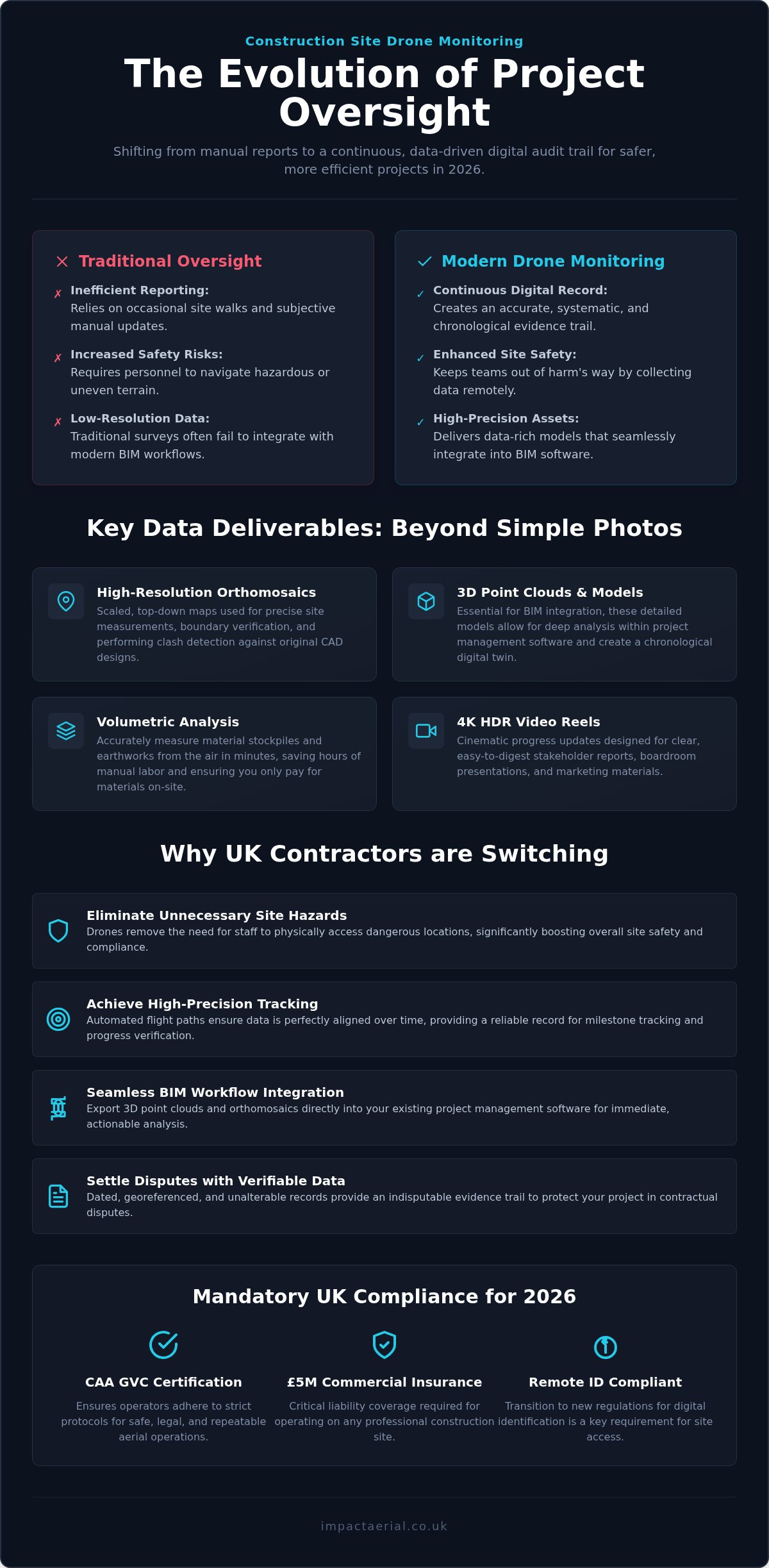
- High-resolution orthomosaics: These are scaled, top-down maps used for precise site measurements and boundary verification.
- 3D point clouds: Essential for BIM integration, these models allow for detailed analysis within project management software.
- Volumetric analysis: Drones accurately measure material stockpiles and earthworks from the air, saving hours of manual labour.
- 4K HDR video reels: Cinematic progress updates specifically designed for high-level boardroom presentations and marketing.
Orthophotos and Site Mapping
Georeferenced orthophotos are essential for modern contractors. By using these scaled maps, teams can perform clash detection, comparing the “as-built” progress against the original CAD designs. This identifies discrepancies early, preventing expensive rework. Because these records are dated and unalterable, they serve as a critical evidence trail in contractual disputes. This provides the psychological comfort that your project is protected by a verifiable digital record. Measuring material quantities used to involve slow, manual ground surveys, but drones now calculate volumes of soil or gravel in minutes, ensuring you only pay for what’s actually on-site.
3D Models and Virtual Tours
Remote stakeholder management is now a standard requirement for large-scale builds. We create immersive virtual tours that allow investors to walk through a site from their office. These 3D models are also used by site managers to plan complex logistics, such as vehicle access routes and crane positioning. Our DJI Enterprise drones use 4K HDR sensors to capture fine details, such as structural structural elements or drainage issues, that traditional site cameras often miss. This level of clarity provides a comprehensive visual record that ground-based photography simply cannot match.
Every flight is conducted in strict accordance with UK Civil Aviation Authority (CAA) drone regulations, ensuring your data is collected within a compliant and safe framework. If you’re ready to transition to a data-driven site, our professional construction site monitoring services provide the technical precision your project requires.
Why UK Contractors are Switching to Drone-Based Progress Tracking
The adoption of construction site drone monitoring UK is driven by a fundamental need for better risk management and operational efficiency. In 2026, the construction industry faces tighter margins and stricter safety standards than ever before. Traditional methods of site oversight are struggling to keep pace with these demands. By integrating aerial data, contractors are replacing subjective reports with objective, high-resolution truth.
- Enhanced Site Safety: Drones remove the need for personnel to navigate hazardous stockpiles, uneven terrain, or active machinery zones.
- Cost-to-Value Ratio: Aerial monitoring provides a significantly higher density of data than ground surveys in a fraction of the time.
- Stakeholder Transparency: Clear visual evidence supports payment certificates and reduces disputes over the timing of completed work.
- Verifiable Data: Precision drone surveys validate earthworks and grading against the original site design.
Solving the ‘Manual Walk’ Problem
Manual site walks are inherently inconsistent. They’re prone to human error, where a project manager might miss a subtle structural issue or overlook a specific area of the site. Documentation often has gaps between visits, leaving contractors vulnerable to claims. A professional drone can capture comprehensive data across a 50-acre site in minutes rather than the hours required for a ground-based inspection. This speed ensures that site managers spend less time walking and more time making data-driven decisions. It’s about creating a systematic, repeatable process that ground teams can rely on week after week.
Investor and Client Reporting
Building trust with project funders requires more than just spreadsheets. High-quality aerial filming provides cinematic updates that resonate in the boardroom. These visual assets allow remote stakeholders to see the exact status of a build without the cost or time of a physical site visit. Using time-lapse drone footage, you can showcase project milestones over several months, providing a powerful narrative of the project’s success. This level of transparency reassures investors that their capital is being managed effectively, while reducing the logistical burden on the site team. It’s a professional standard that modern UK contractors now consider essential for high-tier projects.
Compliance and Safety: Navigating UK Drone Regulations in 2026
As of January 1, 2026, the regulatory framework for construction site drone monitoring UK has become significantly more robust. The introduction of mandatory Remote ID for all UK class-marked drones ensures that every commercial flight is traceable and accountable. For contractors, this means that compliance isn’t just a legal checkbox; it’s a critical component of site risk management. Operating a drone on an active build requires more than technical skill. It demands a deep understanding of the Civil Aviation Authority (CAA) framework to protect the main contractor from liability.
- CAA GVC Certification: This is the professional standard for commercial operations within visual line of sight.
- £5m Commercial Liability Insurance: This is the industry minimum for protecting personnel and assets on UK sites.
- Remote ID Compliance: Ensuring all hardware broadcasts a valid Operator ID as required by 2026 legislation.
- FRZ Management: Coordinating with Air Traffic Control when sites fall within Flight Restriction Zones or urban centres.
Understanding the GVC Certification
The General Visual Line of Sight Certificate (GVC) is the essential UK drone license for any pilot conducting commercial work on a construction site. Hiring an uncertified hobbyist or a pilot without a valid GVC creates immense legal risk. If an incident occurs, using an uncertified operator typically voids the site’s primary insurance policy. We maintain meticulous records of our certifications and CAA permissions, providing the psychological comfort that your project remains fully compliant with current national aviation standards.
Insurance and Risk Mitigation
Safety on a high-pressure site begins long before the drone takes off. Our £5m commercial liability insurance is specifically tailored for the construction sector, providing a level of protection that consumer policies cannot match. Every mission includes a comprehensive pre-flight planning phase. This involves checking NOTAMs (Notices to Air Missions), monitoring localized weather patterns, and conducting site-specific safety briefings with your site manager.
Urban sites present unique challenges, such as signal interference and tight physical constraints. Our DJI Enterprise drones feature redundant safety systems, including multi-directional obstacle avoidance and “return-to-home” protocols that trigger if a connection is lost. These technical safeguards, combined with our rigorous risk assessments, ensure that data collection never compromises ground crew safety. If you need a partner that prioritizes regulatory excellence, contact us to discuss our professional drone monitoring services for your next project.
Implementing Drone Monitoring with Impact Aerial
Integrating construction site drone monitoring UK into your project requires a partner who understands the nuances of the national construction landscape. Based in Birmingham, we provide specialized services across the West Midlands and the wider UK, ensuring that aerial data is not just captured but utilized effectively to drive project success. Our approach centers on meticulous planning to ensure that every flight aligns perfectly with your specific project milestones and reporting cycles.
We utilize commercial-grade DJI Enterprise drones equipped with high-performance 4K HDR camera equipment. This hardware advantage ensures that we capture high-precision data even in challenging lighting or environmental conditions. Whether you’re tracking a new build in a dense urban environment or monitoring a sprawling infrastructure project, our technology provides the qualitative and technical output required for modern industry leadership. Our pilots are CAA GVC certified, providing the reassurance that every operation is conducted with the highest regard for safety and compliance.
The Impact Aerial Workflow
Our workflow is structured and methodical, designed to provide psychological comfort through total reliability. It begins with a comprehensive initial site assessment and a rigorous regulatory check to identify any Flight Restriction Zones or specific safety requirements. Once the parameters are established, we conduct scheduled flight missions that can be weekly, monthly, or based on critical project milestones. All captured data is processed and delivered via secure cloud platforms, allowing your team to access georeferenced maps and progress updates from any location without delay.
From Raw Data to Post-Production
One of our primary strengths is the end-to-end service model. We don’t just provide raw files; our post-production services transform raw data into professional reports and cinematic videos. For your internal engineering teams, we provide CAD-ready files that integrate directly into existing project management software, facilitating accurate measurements and clash detection. Simultaneously, we edit footage into high-end marketing assets for investor presentations, bridging the gap between technical data and visual storytelling. By acting as a single partner from the initial consultation to the final edit, we ensure a seamless integration with your project workflows and maintain a consistent standard of high-tier quality throughout the entire build lifecycle.
Securing the Future of Your Site Oversight
Professional construction site drone monitoring UK has transitioned from an optional visual aid to a critical digital audit trail. By 2026, the integration of high-precision DJI Enterprise hardware and CAA-compliant flight protocols has set a new standard for project transparency. You now have the tools to replace manual site walks with verifiable 4K data, reducing safety risks while providing stakeholders with undeniable proof of progress. This meticulous approach ensures your project remains on schedule and protected from potential contractual disputes.
Based in the West Midlands with full UK coverage, Impact Aerial provides the technical expertise your project requires. Our pilots are CAA GVC certified and backed by £5m commercial liability insurance, ensuring your site operations are both safe and legally compliant. We handle everything from initial risk assessments to the delivery of CAD-ready files and high-end marketing assets. Request a Professional Drone Monitoring Consultation to transform your site into a data-driven environment. We look forward to helping you build with greater precision and confidence.
Frequently Asked Questions
Do I need to notify the CAA for drone monitoring on my site?
Professional pilots handle all regulatory notifications. While you don’t need to contact the CAA yourself, your operator must ensure the flight is compliant with 2026 Remote ID requirements and any local Flight Restriction Zones. We manage all necessary permissions and risk assessments as part of our service. This ensures your project remains within the law without adding administrative burden to your site management team.
How often should drone monitoring be conducted for a large project?
Frequency typically depends on the pace of your build and specific project milestones. Most UK contractors opt for weekly or fortnightly missions to maintain a consistent digital twin. For large-scale infrastructure, monthly flights might suffice for high-level oversight. We align our flight schedule with your reporting requirements, ensuring that every data capture provides meaningful progress tracking for your payment certificates and stakeholder updates.
Can drones operate in typical UK weather conditions?
Modern DJI Enterprise drones are designed to handle moderate wind and light precipitation common in the UK. However, for safety and data quality, we don’t fly in heavy rain or wind speeds exceeding the manufacturer’s safety limits. We monitor localized weather patterns meticulously to reschedule flights if conditions are unsuitable. This ensures the 4K HDR data we capture is clear, accurate, and gathered without risking personnel or equipment.
What is the difference between a drone survey and drone monitoring?
A drone survey is generally a one-off technical exercise focused on high-precision measurements like topographic mapping or volumetric analysis. In contrast, construction site drone monitoring UK is a recurring service designed to track progress over time. While monitoring uses survey-grade data, its primary goal is creating a chronological record of the build. This allows project managers to compare as-built progress against the original design throughout the construction lifecycle.
Is drone monitoring safe on a busy site with cranes and machinery?
Yes, professional monitoring is safe when conducted by CAA GVC certified pilots. We use hardware with multi-directional obstacle avoidance and redundant safety systems to navigate around cranes and machinery. Every mission begins with a site-specific risk assessment to identify potential hazards. By maintaining a safe distance from active plant and following strict visual line of sight protocols, we capture data without ever interrupting your ground crews’ workflow.
How much does construction site drone monitoring cost in the UK?
Pricing for monitoring services depends on the site size, flight frequency, and the specific data deliverables required. While we don’t provide fixed price lists, factors such as the complexity of the airspace and the level of post-production editing also influence the final cost. We focus on providing a high cost-to-value ratio by delivering accurate, digital audit trails that reduce the need for slow, manual site inspections.
What file formats will I receive for my BIM software?
We provide data in various industry-standard formats that integrate seamlessly with your existing BIM and CAD workflows. Common deliverables include .TIFF files for orthomosaic maps, .LAS or .XYZ files for 3D point clouds, and .OBJ files for textured 3D models. These CAD-ready assets allow your engineering team to perform precise measurements and clash detection. We also deliver high-resolution 4K video reels for your non-technical stakeholder presentations.
Does the drone pilot need to be on-site at all times?
No, our pilots are only on-site during the active data capture phase. A typical mission for construction site drone monitoring UK takes between one and four hours depending on the site’s acreage and complexity. Once the flight is complete and the raw data is verified, our team handles all processing and post-production at our Birmingham base. You receive the final reports and digital assets via a secure cloud platform shortly after the flight.
 2 Norton Drive, Wythall, Birmingham, B47 6HH Company registration number: 11138586. VAT Number: 366 9068 55


